ILLINOIS POLLUTION CONTROL BOARD
May 4, 2006
IN THE MATTER OF:
SETBACK ZONE FOR CITY OF
MARQUETTE HEIGHTS COMMUNITY
WATER SUPPLY, NEW 35 ILL. ADM.
CODE 618
)
)
)
)
)
)
R05-9
(Rulemaking - Public Water Supply)
Adopted Rule. Final Order.
OPINION AND ORDER OF THE BOARD (by A.S. Moore):
The Board today adopts final rules that establish an expanded setback zone of up to 1,000
feet to provide additional protection for the community water supply (CWS) wells of the City of
Marquette Heights, in Tazewell County. The proponent of this rulemaking is the Illinois
Environmental Protection Agency (Agency), acting at Marquette Heights’ request. On
December 2, 2005, first notice of the proposed rules was published in the
Illinois Register
. On
April 11, 2006, the Joint Committee on Administrative Rules (JCAR) issued a certification of no
objection concerning the second-notice rules. The Board will now file the adopted rules with the
Secretary of State for publication in the
Illinois Register
as final rules.
This rulemaking is the first of its kind under Section 14.3(d) of the Environmental
Protection Act (Act) (415 ILCS 5/14.3(d) (2004)), which allows for the establishment of
“maximum setback zones” to prevent contamination of particularly vulnerable groundwater
sources used by CWS. These final public water supply rules create a new Part 618 of Title 35 of
the Illinois Administrative Code.
In this opinion, the Board first provides the procedural history of this rulemaking. The
Board then discusses the legal framework for setback zone protection in Illinois, the
developments leading to the Agency’s proposal, and the contents of and justification for the final
rules. The rules themselves appear in the order following this opinion.
PROCEDURAL HISTORY
The Agency filed the rulemaking proposal on November 5, 2004. In an order of
December 2, 2004, the Board accepted the Agency’s proposal for hearing.
1
The Board has held
two hearings in this rulemaking. The first hearing took place in Pekin on March 1, 2005, and the
second hearing took place in Chicago on April 5, 2005.
At the first hearing, three witnesses testified: Richard P. Cobb, Deputy Manager of the
Division of Public Water Supplies of the Agency’s Bureau of Water; David Redfield, Mayor of
Marquette Heights; and Rick Crum, Superintendent of Marquette Heights. Cobb testified at the
1
The Board cites the Statement of Reasons in the Agency’s proposal as “Stat. of Reas. at _.”
2
second hearing.
2
Also participating at hearing were attorneys Kimberly A. Geving and
Stephanie Flowers on behalf of the Agency; Michael J. Tibbs, City Attorney with Miller, Hall,
and Triggs on behalf of Marquette Heights; Steve Little, an Alderman on the Marquette Heights
City Council; and Harold S. Primack, Environmental Business Manager for Atlantic Richfield
Company, a BP affiliated company.
The Board hearing officer admitted twelve exhibits (Exhibits A-L) into the record over
the course of the two hearings.
3
Nine of the twelve exhibits were offered by the Agency. The
other three exhibits were offered by Marquette Heights. The exhibits include an “
Errata
Sheet
Number 1” (Exhibit F) offered by the Agency, which shows proposed changes to the rule
language originally set forth in the Agency’s proposal.
The transcripts of the Pekin and Chicago hearings were received by the Board on
March 11 and April 20, 2005, respectively, and promptly placed in the Clerk’s Office On Line
(COOL) on the Board’s Web at www.ipcb.state.il.us. Many other documents from this
rulemaking record are available through COOL, including Board opinions and orders.
Section 27(b) of the Act requires the Board to request that the Department of Commerce
and Economic Opportunity (DCEO) conduct an economic impact study (EcIS) of proposed
substantive rules. Section 27(b) of the Act also requires the Board to make DCEO’s response
available at least 20 days before holding a public hearing on the proposal’s economic impact.
See
415 ILCS 5/27(b) (2004). However, Section 14.3(d) of the Act (415 ILCS 5/14.3(d) (2004))
provides that Section 27(b) does not apply to rulemaking proceedings initiated by the Agency
under Section 14.3(d), like this one. Accordingly, the Board hearing officer did not solicit any
testimony at hearing regarding the issue of DCEO performing an EcIS.
On November 17, 2005, the Board adopted a first-notice opinion and order. In the first-
notice rules, the Board made several minor, clarifying changes to the Agency’s proposed rule
language. On December 2, 2005, the
Illinois Register
published first notice of the Board’s
proposed rules (29 Ill. Reg. 19503 (Dec. 2, 2005)). This began a 45-day period during which any
interested person could file with the Board a public comment on the proposed rules. The Board
received no public comments on this rulemaking, either before or after first-notice publication.
On December 5, 2005, the Board received from JCAR several minor suggested changes
to the first-notice rule text adopted by the Board. JCAR’s suggestions were reflected in the
second-notice rules adopted by the Board on February 16, 2006. On April 11, 2006, JCAR
issued a certification of no objection concerning the second-notice rules. The Board today
makes only minor changes to the second-notice rules, again at the request of JCAR.
2
The Board cites the transcript of the first hearing as “Tr.1 at _” and the transcript of the second
hearing as “Tr.2 at _.”
3
The Board cites the hearing exhibits as “Exh. _ at _.”
3
DISCUSSION
Legal Framework
Section 14.2 of the Act (415 ILCS 5/14.2 (2004)) establishes a “
minimum
setback zone”
of 200 feet around each CWS well in Illinois.
See
415 ILCS 5/14.2(a) (2004). In specified
instances where the CWS derives water from an especially vulnerable geological formation, the
minimum setback zone is 400 feet.
See
415 ILCS 5/14.2(d) (2004).
A setback zone restricts land use near the CWS well, providing a buffer between the well
and potential sources or routes of contamination. The Act defines a CWS as a “public water
supply which serves or is intended to serve at least 15 service connections used by residents or
regularly serves at least 25 residents.” 415 ILCS 5/3.145 (2004). Generally, absent a setback
exception issued by the Board, various defined new “potential primary sources,” “potential
secondary sources,” or “potential routes” of contamination cannot be placed within the minimum
setback zone of a CWS well.
See
415 ILCS 5/14.2(a), (c) (2004).
Section 14.3 of the Act (415 ILCS 5/14.3 (2004)), which is at the heart of this
rulemaking, allows for
additional
protection beyond the minimum setback zone. Under
specified circumstances, Section 14.3 authorizes either the Board, or the county or municipality
served by a CWS well, to establish a “
maximum
setback zone” of up to 1,000 feet from the CWS
wellhead.
4
Subsection (d) of Section 14.3 provides that the Board may adopt a maximum
setback zone after receiving an Agency rulemaking proposal. Specifically, Section 14.3(d) reads
in part:
[U]pon written notice to the county or municipality, the Agency may propose to
the Board a regulation establishing a maximum setback zone for any well subject
to this Section. Such proposal shall be based upon all reasonably available
hydrogeologic information, include the justification for expanding the zone of
wellhead protection, and specify the boundaries of such zone, no portion of which
boundaries shall be in excess of 1,000 feet from the wellhead. Such justification
may include the need to protect a sole source of public water supply or a highly
vulnerable source of groundwater, or an Agency finding that the presence of
potential primary or potential secondary sources or potential routes represents a
significant hazard to the public health or the environment. 415 ILCS 5/14.3(d)
(2004).
Development of Agency’s Proposal
Marquette Heights is located near the intersection of Interstate Route 474 and Illinois
Route 29, in Tazewell County. Marquette Heights sits primarily on a bluff overlooking the
valley occupied by the Illinois River. Marquette Heights’ two CWS wells are located in the
Village of North Pekin, which lies to the west of Marquette Heights. Exh. C at 1; Exh. G. The
4
In limited instances, a county or municipality may adopt an ordinance establishing a maximum
setback zone of up to 2,500 feet from the wellhead.
See
415 ILCS 5/14.3(f) (2004).
4
Marquette Heights wells, which are in close proximity to one another, have minimum setback
protection of 400 feet. Tr.1 at 15-16; Exh. G.
Section 14.3 of the Act, as indicated, authorizes counties, municipalities, and the Board to
establish maximum setback zones. Marquette Heights lacks the legal authority to establish a
maximum setback zone by ordinance because its CWS wells are in North Pekin. Tr. 1 at 10-12.
On March 22, 2004, Marquette Heights adopted a resolution requesting that the Agency propose
a rule to the Board that would increase the setback zone around the Marquette Heights CWS
wells. Stat. of Reas. at 1.
The Agency states that it met the notice requirements of Section 14.3(d) of the Act.
Section 14.3(d) reads in part:
[U]pon written notice to the county or municipality, the Agency may propose to
the Board a regulation establishing a maximum setback zone for any well subject
to this Section. *** The Agency may proceed with the filing of such a proposal
unless the county or municipality, within 30 days of the receipt of the written
notice, files a written request for a conference with the Agency. 415 ILCS
5/14.3(d) (2004).
According to the Agency, it provided notice of the rulemaking proposal by certified mail
to Marquette Heights, North Pekin, and the Tazewell County Zoning Office in June 2004. Stat.
of Reas. at 7; Tr.1 at 8, 41. The proposal notes that the Agency received no comments within the
statutory 30-day period from any of these governmental entities. Stat. of Reas. at 8; Tr.1 at 8.
The Agency proposal provides that at separate meetings held in July 2004, the following
organizations concluded that they had no objections to the Agency proceeding with the proposal:
(1) the Central Regional Priority Groundwater Protection Planning Committee, established under
Section 17.2 of the Act (415 ILCS 5/17.2 (2004)) as one of four priority groundwater protection
planning regions in the State;
5
and (2) the Interagency Coordinating Committee on Groundwater
and the Groundwater Advisory Council, both established under the Illinois Groundwater
Protection Act (415 ILCS 55 (2004)).
6
Stat. of Reas. at 4, 7; Tr.1 at 8-9, 41.
5
The central region consists of Mason, Peoria, Tazewell, and Woodford Counties. Each of the
four regions has a committee comprised of representatives of counties, municipalities, public
water supplies, and members of the general public, including persons with business,
environmental, and agricultural interests. Stat. of Reas. at 4.
6
The Interagency Coordinating Committee on Groundwater is chaired by the Agency and
comprised of the Illinois Department of Public Health, the Illinois Department of Natural
Resources, the Illinois Department of Agriculture, the Illinois State Fire Marshal, the Department
of Commerce and Economic Opportunity, and the Illinois Emergency Management Agency.
Stat. of Reas. at 7. The Groundwater Advisory Council is comprised of environmental, business,
public water supply, county and municipal government, regional planning, and water well driller
interest group representatives. The Agency’s proposal stated that these two organizations (1)
5
BP Amoco is conducting a groundwater cleanup at a tank farm north of the maximum
setback zone. Although BP Amoco was apparently not notified by the Agency about the
proposal, representatives of the company are aware of the rulemaking and participated at
hearing. Tr.1 at 41-42. Cobb, Deputy Manager of the Agency’s Division of Public Water
Supplies, testified that this rulemaking has “no direct bearing” on the BP Amoco tank farm
cleanup.
Id
. at 41.
In response to the request from Marquette Heights and findings indicating the
vulnerability of the City’s CWS wells, the Agency proposed this rulemaking to establish a
maximum setback zone of up to 1,000 feet, as depicted on a map in Section 618.APPENDIX A
of the rules. In addition to the maximum setback rulemaking, the Agency recommended
activities to Marquette Heights to further minimize the risk to the Marquette Heights CWS. The
Agency suggested that Marquette Heights develop a contingency plan, review its cross-
connection control ordinance, abandon two inactive wells, replace screens on the two current
wells, and implement a wellhead protection program. Exh. A, Attachment V at 4.
Final Rules
In adopting final rules today, the Board has made no substantive changes to the rules
proposed at second notice. This rulemaking expands the setback zone around the drinking water
wells used by Marquette Heights. The rules include the Act’s definition of a “setback zone.” A
“setback zone” means:
a geographic area, designated pursuant to the Act, containing a potable water
supply well or a potential source or potential route, having a continuous
boundary, and within which certain prohibitions or regulations are applicable in
order to protect groundwaters
[415 ILCS 5/3.450].
See
Section 618.105.
As discussed in more detail below, this record demonstrates that the rules are needed to
protect the groundwater supplied to Marquette Heights residents as drinking water. Stat. of
Reas. at 1, 5. Marquette Heights has two CWS wells. As noted, the wells are located not in
Marquette Heights, but rather in North Pekin, also in Tazewell County. The wells have an
estimated average daily pumpage from the groundwater source of 240,000 gallons per day,
supplying approximately 3,200 persons directly.
Id
. at 4-5. Marquette Heights’ water system
has approximately 1,064 service connections within the corporate limits and another 56 service
connections in an area of anticipated future expansion east of the City. Exh. C at 2-3.
Based on various assessments, including groundwater flow and recharge area modeling,
the Agency concluded that the Marquette Heights CWS wells are not adequately protected by the
current minimum setback zones, and that the groundwater source is “highly vulnerable.” Stat. of
Reas. at 5-6. In addition, the Agency issued an “advisory of groundwater contamination hazard”
work jointly, with the Agency as liaison between them; and (2) work with the four regional
priority groundwater planning committees described in the preceding footnote.
Id
.
6
for North Pekin and Marquette Heights in July 1990 because of potential sources of groundwater
contamination that represented a “significant hazard to public health and the environment.”
Id
.
The Agency maintains therefore that expanding the zone of wellhead protection is justified, as
Section 14.3(d) of the Act requires.
Id
. at 7.
As adopted, the new Part 618 of the Board’s public water supply rules has two subparts:
Subpart A and Subpart B. In Subpart A of Part 618, there are general provisions for maximum
setback zones, including definitions. Subpart A’s provisions apply to all maximum setback
zones established in Illinois through Board rulemaking, including this first such maximum
setback, the Marquette Heights maximum setback.
In Subpart B of Part 618, there are rules specific to the Marquette Heights CWS wells.
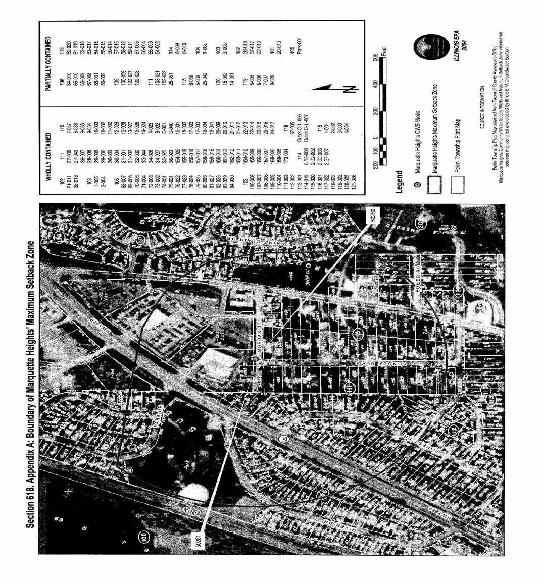
Subpart B includes an appendix (Section 618.APPENDIX A) with a map that delineates the
irregularly-shaped boundaries of the maximum setback zone relative to local land use plats. Tr.1
at 9. The distance from the wells to the setback boundaries varies from approximately 600 to
1,000 feet. Exh. G. The appendix also lists identification numbers of parcels that are located
wholly or partially within the maximum setback.
Additionally, Subpart B of Part 618 states that (1) certain activities within the setback are
banned and (2) other activities within the setback are subject to management and control
standards. First, “new potential primary sources” of groundwater contamination are prohibited
from locating wholly or partially within the Marquette Heights expanded setback.
See
Sections
618.200(b)(1) and 618.205. The Act’s definition of a “potential primary source” is set forth in
the rules. A “potential primary source” means:
any unit at a facility or site not currently subject to a removal or remedial action
which:
is utilized for the treatment, storage, or disposal of any hazardous or
special waste not generated at the site; or
is utilized for the disposal of municipal waste not generated at the site,
other than landscape waste and construction and demolition debris; or
is utilized for the landfilling, land treating, surface impounding or piling
of any hazardous or special waste that is generated on the site or at other
sites owned, controlled or operated by the same person; or
stores or accumulates at any time more than 75,000 pounds above ground,
or more than 7,500 pounds below ground, of any hazardous substances
[415 ILCS 5/3.345].
See
Section 618.105.
In turn, a “new potential primary source,” to which the location prohibition would apply, is
defined in the Act and rules as:
7
a potential primary source which is not in existence or for which construction has
not commenced at its location as of January 1, 1988; or
a potential primary source which expands laterally beyond the currently
permitted boundary or, if the primary source is not permitted, the boundary in
existence as of January 1, 1988; or
a potential primary source which is part of a facility that undergoes major
-
reconstruction. Such reconstruction shall be deemed to have taken place where
the fixed capital cost of the new components constructed within a 2-year period
exceed 50% of the fixed capital cost of a comparable entirely new facility
[415
ILCS 5/3.345].
See
Section 618.105.
Second, Subpart B of Part 618 specifies that the Board’s Part 615 or Part 616 “technical
standards” or “technology control regulations” (35 Ill. Adm. Code 615 and 616) apply to those
new or existing activities regulated by Part 615 or Part 616 that are located wholly or partially
within the expanded Marquette Heights setback.
See
Section 618.200(b)(2); Tr.1 at 30, 42-43.
The rules make clear, however, that agrichemical facilities that affirmatively opt out of Part 615
or Part 616 are regulated instead under rules of the Department of Agriculture (8 Ill. Adm. Code
257) or the Department of Public Health (77 Ill. Adm. Code 830).
See
Section 618.200(b)(2);
see also
415 ILCS 5/14.6 (2004); Tr.1 at 43-45; Tr.2 at 8-11; Exh. F.
Part 615 (“Existing Activities in a Setback Zone or Regulated Recharge Area”) and Part
616 (“New Activities in a Setback Zone or Regulated Recharge Area”) contain groundwater
monitoring, design, inspection, operating, closure, and post-closure requirements. Parts 615 and
616 generally apply to on-site landfills, on-site land treatment units, on-site surface
impoundments, on-site waste piles, underground storage tanks, pesticide storage and handling
units, fertilizer storage and handling units, road oil storage and handling units, and de-icing agent
storage and handling units.
As Cobb explained, Parts 615 and 616, by their own terms, apply within setback zones,
so their application within the Marquette Heights maximum setback zone will be “automatic . . .
upon the effective date of the establishment of this maximum setback zone.” Tr.1 at 43. For
further clarity, Section 618.200(b)(2) cross-references Parts 615 and 616.
Id
. Cobb added,
however, that the Agency’s analysis did not reveal any activities within the expanded setback
that would become subject to the technical standards because of this rulemaking.
Id
. at 48-49.
Conditions Justifying Expansion of the Marquette Heights Setback
Environment
Marquette Heights’ two CWS wells (wells #4 and #5, also identified as wells 50280 and
50281) are located outside of and to the west of the City, in North Pekin, on the Illinois River
floodplain. Both wells are approximately 95 feet deep and are screened in the Sankoty Sand or
Henry Formation. Exh. A at 13-14; Tr.1 at 31-33, 54. Accessible portions of the Sankoty
8
aquifer appear to lie outside of the corporate limits of Marquette Heights. Tr.1 at 54; Exh. C at
4.
Digging a deeper well would not be an effective means of providing water. Cobb
testified that “[i]n this part of the State as you transgress south from Northern Illinois, the deeper
aquifer systems become saline in nature due to their depth.” Tr. 1 at 58. Concerns would arise
due to naturally occurring high levels of total dissolved solids (TDS), sulfate, and radionuclides.
Id
.
The Agency conducted a source water assessment pursuant to the Federal Safe Drinking
Water Act (SDWA) (42 U.S.C. § 300f
et seq
.) for Marquette Heights. Stat. of Reas. at 6; Tr.1 at
23. The assessment, which was completed in April 2003, evaluated existing water quality,
geologic vulnerability, and existing potential sources of groundwater contamination to determine
the overall susceptibility of the Marquette Heights CWS wells. The assessment found that the
wells are susceptible to groundwater contamination. Stat. of Reas. at 5-6.
Twenty-two potential sources of contamination within 1,000 feet of the CWS wells were
identified in the “Source Water Assessment Program Fact Sheet” for Marquette Heights. Exh.
A, Attachment V. The Agency’s main motivation for issuing the 1990 advisory, however, was
an Amoco Mobil (now BP Amoco) tank farm remediation site located north of the Marquette
Heights wells. Tr.1 at 22, 33-34, 37-40, 63; Exh. A at 11, Attachment V; Exh. B, D, G.
There is no evidence that the groundwater contamination plume from the BP Amoco tank
farm is within the maximum setback. Tr.1 at 18. Indeed, Cobb believes that the BP Amoco
contaminant plume is not off-site at this time and is contained on the tank farm site with
hydraulic pumping.
Id
. at 18-21. According to Cobb, BP Amoco is:
doing a very active remediation, pump and treat, hydraulic containment, active
soil venting and bioventing because they have free product there as well as
dissolved contaminants including methyl tertiary butyl ether [MTBE] which is
very mobile. And, of course, they are surrounded by Creve Coeur public water
supply to the north and right now North Pekin and Marquette Heights on the
south. Tr.1 at 13.
Contamination was found in monitoring wells within the setback zone of North Pekin
well #1 (also identified as well 50210). Exh. A, Attachment V at 2; Exh. G. Marquette Heights’
two CWS wells are located just east of North Pekin well #1. Exh. A, Att. V at 2; Exh. G; Tr.1 at
31-32, 54.
A maximum setback zone around North Pekin’s well #1 currently encompasses the two
Marquette Heights wells. North Pekin, however, is in the process of abandoning well #1 and
drilling another well in a different location. Tr. 1 at 11-12, 59-60; Exh. C at 7. Cobb testified
that North Pekin, in negotiation with BP Amoco, would relocate well #1, extinguishing North
Pekin’s current maximum setback zone. According to Cobb, under the Tiered Approach to
Corrective Action Objectives (TACO) (35 Ill. Adm. Code 742), extinguishing the current
maximum setback zone of North Pekin would allow BP Amoco to extend the point of
9
compliance for the remediation. Tr.1 at 11. Specifically, BP Amoco could show compliance
with the groundwater standards at the minimum setback of 400 feet from the Marquette Heights
CWS wells, instead of at a location farther away from the wells, at the current North Pekin
maximum setback boundary.
Id
. at 15-16.
When North Pekin’s well is relocated, Marquette Heights expects to lose the protection it
has been receiving indirectly from North Pekin’s overlapping maximum setback. Tr.1 at 12, 60,
63. Marquette Heights wants to preserve that area of protection through this rulemaking.
Id
. at
12. With a new maximum setback zone that, as delineated, ranges from roughly 600 to 1,000
feet from the Marquette Heights wells, the point of compliance under TACO (
i.e.
, where BP
Amoco would be required to meet the groundwater standards) would move farther away from
wells #4 and #5 than with the 400-foot minimum setback zone.
Id
. at 15-17.
Cobb stated that the rule currently has no direct bearing on the BP Amoco remediation or
on the consent order requiring the cleanup, although the setback might in the future. Tr. at 41;
Exh. K. As to the other potential sources of contamination identified in the “Source Water
Assessment Program Fact Sheet,” the Agency’s analysis showed the rules would have no
immediate impact on any particular type of existing activity or potential source. Tr. 1 at 48-49.
The Agency contracted with RAPPS Engineering and Applied Science (RAPPS) to
model the groundwater flow and delineate the recharge area and wellhead protection area
(WHPA) for the Marquette Heights CWS wells. Stat. of Reas. at 4; Exh. A at 4; Exh. H; Tr.1 at
25-28. A WHPA is “the surface and subsurface area around a water well field, supplying a
public water system, through which contaminants are reasonably likely to move toward and
reach such water well or well field.” Exh. L at 2-3. To delineate a WHPA, the capture zone of a
well must be determined and projected on to the land surface.
Id
. at 3. A capture zone is “the
entire area recharging or contributing water to the well, a three-dimensional volume of aquifer
that may or may not intersect the land surface.”
Id
.
The Marquette Heights maximum setback zone is based on a sophisticated technique for
determining the lateral area of influence (LAI) under 35 Ill. Adm. Code 671.201(g),
7
Illinois’
Wellhead Protection Program approved by the United States Environmental Protection Agency
(USEPA), and guidance for conducting groundwater protection needs assessments (Cobb,
et al
.
1995). Exh. A at 4; Tr.1 at 25-28. Other resources that were considered included
Guidelines for
the Delineation of Wellhead Protection Areas
(USEPA, 1987) and
Model Assessment for
Delineating WHPAs
(USEPA, 1988).
In addition, modeling was performed consistent with
Applied Groundwater Modeling
Simulation of Flow and Advective Transport
(Anderson and Woessner, 1992). Exh. A at 4.
RAPPS created a groundwater flow model and delineated the capture zone using MODFLOW
and MODPATH, the United States Geological Survey (USGS) groundwater flow modeling
7
The Part 671 rules (35 Ill. Adm. Code 671), which were adopted by the Agency, provide
procedures to be used by counties or municipalities interested in establishing maximum setback
zones around CWS wells by ordinance. The rules include procedures for a county or
municipality to request Agency review of the local government’s LAI determination.
10
program and particle tracking program, respectively (McDonald and Harbough, 1988; Pollock,
1989). Exh. L at 3. The model was reviewed and approved by the Agency. Exh. A at 4.
A WHPA was constructed by outlining the area encompassed by the capture zones
produced by the model. Exh. A at 24; Exh. G, H. Delineating WHPAs fulfills part of the
requirements of Section 1428(a) of the federal SDWA (42 U.S.C. § 300h-7(a)). Exh. L at 1. In
general, a WHPA was established by the Illinois Groundwater Protection Act as a 1,000-foot
fixed radial area around each CWS well in Illinois. For unconfined aquifers, WHPAs are further
delineated using models and hydrogeologic mapping to determine “five-year time-related capture
zones,” which might extend beyond the 1,000-foot radius. Exh. L at 2.
The WHPA, as outlined by the model capture zones for the Marquette Heights CWS
wells, led to the determination of an irregular shaped maximum setback zone within the WHPA,
up to 1,000 feet from the two wellheads. Stat. of Reas. at 6; Exh. G, H. The setback zone is
depicted on a map in Appendix A of the rules. Stat. of Reas. at 6. The map details the location
of the Marquette Heights CWS wells and maximum setback zone boundaries, as well as local
roads and property boundaries.
Id
. at 9. The Agency’s modeling also accounted for scenarios of
the North Pekin well and the BP Amoco wells being closed. Tr.1 at 49-50.
The evaluation took into account the regional groundwater gradient, LAI, and pumping
stresses. Stat. of Reas. at 5-6. Other pumping stresses on the same aquifer included the wells of
Creve Couer, Pekin, North Pekin, and Groveland Township, plus 15 wells operated by BP
Amoco as part of the subsurface contamination cleanup system. Tr. 1 at 33; Exh. A at 16.
Results demonstrated that recharge is occurring beyond the minimum setback zones, and that the
Marquette Heights CWS wells are not adequately protected. Stat. of Reas. at 6; Exh. H.
Economics
Marquette Heights Mayor, David Redfield, testified that “wells number 4 and 5 are the
only source of raw water for the city’s system.” Tr.1 at 54; Exh. C at 3. The record indicates
that relocating the Marquette Heights CWS wells is impractical. Based on the City’s research,
there are no suitable alternate sites for the wells. Longer pipelines (as well as associated
pumping facilities, easements, and land acquisition) needed to deliver the water are cost-
prohibitive. Also, as noted, ready access to the Sankoty aquifer is lacking, such as within
Marquette Heights’ corporate limits, and deeper aquifers raise concerns over high levels of TDS,
sulfate, and radionuclides. Tr. at 54, 58-59; Exh. C at 3-6.
Further, using the Illinois River as a source is also not an effective solution. The river is
outside the boundaries of Marquette Heights and higher costs would apply to delivery and
treatment. Tr. 1 at 57. Mayor Redfield emphasized that the “limited availability of alternative
sites underscores the importance of protecting the existing sites from contamination.” Exh. C at
5. Even if suitable locations were available for replacement wells in Marquette Heights, the City
estimated that it would cost at least $825,000 to replicate the City’s existing well and treatment
facilities.
Id
. at 5-6.
11
According to Cobb, the rules are economically reasonable and technically feasible. Tr.1
at 48. Cobb also testified that the maximum setback zone would be economically beneficial:
The benefit of prevention in my opinion outweighs the cost of prohibiting any
new potential primary sources of groundwater contamination within the proposed
maximum setback zone. And the theory here is that good water is good business;
that we need good water to maintain the economic growth and economy in an area
as well as . . . to see future growth.
Id
. at 9.
Groundwater contamination can produce “significant economic hardships for local
businesses and communities.” Exh. A at 27. These hardships include:
devalued real estate; diminished home sales or commercial real estate sales; loss
to the tax base; consulting and legal fees; increased operation and maintenance
costs; increased water rates for alternative water supplies as well as the cost of
new equipment and treatment; and remediation costs.
Id
. at 27-28.
For example, the Agency provided information on the substantial costs faced by the
community of East Alton, in Madison County, because of MTBE contamination of groundwater.
Exh. A at 28-29. USEPA has estimated that the “ratio of contamination costs to basic prevention
costs may be as large as 200:1.”
Id
. at 28. Mayor Redfield stated that the enlarged setback
would “decrease the risk both of contaminating those wells [#4 and #5] and of the significant
financial burden which such contamination would impose on the City.” Exh. C at 6.
In addition, according to Mayor Redfield, the “only territory available for further
expansion” of Marquette Heights lies in the largely undeveloped area to the east of the City’s
corporate limits. Exh. C at 2. The Mayor expects new residential and business development to
occur in this area as a result of the construction of a five-lane roadway that will intersect with
Interstate 474.
Id
. Communities that deliver water exceeding the drinking water standards are
placed on restricted status and therefore are generally unable to get permits for water main
extensions. Exh. A at 28.
CONCLUSION
The Board today adopts as final rules a new Part 618 on maximum setback zones. Part
618 has two subparts. Subpart A contains general provisions for maximum setback zones
established in Illinois by Board rulemaking. This is the first such rulemaking. Subpart B has
rules specific to the maximum setback zone for Marquette Heights, which provides expanded
setback zone protection for the City’s two CWS wells.
The final rules reflect several minor changes from second notice, all suggested by JCAR
and none of which merit discussion. Based on this record, the Board finds that the rules are
technically feasible and economically reasonable.
See
415 ILCS 5/27(a) (2004).
12
ORDER
The Board directs the Clerk of the Board to file the following final rules with the
Secretary of State for publication in the
Illinois Register
.
TITLE 35: ENVIRONMENTAL PROTECTION
SUBTITLE F: PUBLIC WATER SUPPLIES
CHAPTER I: POLLUTION CONTROL BOARD
PART 618
MAXIMUM SETBACK ZONES
SUBPART A: GENERAL
Section
618.100 Purpose and Applicability
618.105 Definitions
SUBPART B: MARQUETTE HEIGHTS’ MAXIMUM SETBACK ZONE
Section
618.200 Purpose and Applicability
618.205 1,000 Foot Maximum Setback Zone Prohibition
618.APPENDIX A Boundaries of Marquette Heights’ Maximum Setback Zone
AUTHORITY: Implementing Section 14.3 and authorized by Section 27 of the Illinois
Environmental Protection Act [415 ILCS 5/14.3 and 27].
SOURCE: Adopted in R05-9 at __ Ill. Reg. _______, effective ________________________.
SUBPART A: GENERAL
Section 618.100 Purpose and Applicability
This Part is established in the interest of securing the public health, safety, and welfare; to
preserve the quality and quantity of groundwater resources in order to assure a safe and adequate
water supply for present and future generations; and to preserve groundwater resources currently
in use and those aquifers having a potential for future use as a public water supply. Pursuant to
the authority of Section 14.3(d) of the Illinois Environmental Protection Act (Act) [415 ILCS
5/14.3(d)], the provisions of this Part apply to all properties located wholly or partially within a
maximum setback zone established under Section 14.3(d) of the Act and this Part.
Section 618.105 Definitions
13
Unless a different meaning of a word or term is clear from the context, the definitions of words
or terms in this Part are the same as those used in the Act, the Illinois Groundwater Protection
Act [415 ILCS 55], or 35 Ill. Adm. Code 671.
“Agency” means the Illinois Environmental Protection Agency.
“Board” means the Illinois Pollution Control Board.
“Facility” means
the buildings and all real property contiguous thereto, and the equipment at a
single location used for the conduct of business
[430 ILCS 45/3].
“New Potential Primary Source” means:
a potential primary source which is not in existence or for which construction has not
commenced at its location as of January 1, 1988; or
a potential primary source which expands laterally beyond the currently permitted
boundary or, if the primary source is not permitted, the boundary in existence as of
January 1, 1988; or
a potential primary source which is part of a facility that undergoes major
reconstruction. Such reconstruction shall be deemed to have taken place where the fixed
capital cost of the new components constructed within a 2-year period exceed 50% of the
fixed capital cost of a comparable entirely new facility
[415 ILCS 5/3.345].
“New Potential Route” means:
a potential route which is not in existence or for which construction has not commenced
at its location as of January 1,1988; or
a potential route which expands laterally beyond the currently permitted boundary or, if
the potential route is not permitted, the boundary in existence as of January 1, 1988
[415
ILCS 5/3.350].
“New Potential Secondary Source”
means
a potential secondary source which:
is not in existence or for which construction has not commenced at its location as
of July 1, 1988; or
expands laterally beyond the currently permitted boundary or, if the secondary
source is not permitted, the boundary in existence as of July 1, 1988, other than
an expansion for handling of livestock waste or for treating domestic
wastewaters; or
14
is part of a facility that undergoes major reconstruction. Such reconstruction
shall be deemed to have taken place where the fixed capital cost of the new
components constructed within a 2-year period exceed 50% of the fixed capital
cost of a comparable entirely new facility
[415 ILCS 5/3.355]; but
excludes an agrichemical facility that
modifies on-site storage capacity such that the
volume of the pesticide storage does not exceed 125% of the available capacity in
existence on April 1, 1990, or the volume of fertilizer storage does not exceed 150% of
the available capacity in existence on April 1, 1990; provided that a written endorsement
for an agrichemical facility permit is in effect under Section 39.4 of the
Act and the
maximum feasible setback is maintained. This on-site storage capacity includes mini-
bulk pesticides, package agrichemical storage areas, liquid or dry fertilizers, and liquid
or dry pesticides
[415 ILCS 5/14.2(g)(4)].
“Potential Primary Source” means
any unit at a facility or site not currently subject to a removal
or remedial action which:
is utilized for the treatment, storage, or disposal of any hazardous or special waste not
generated at the site; or
is utilized for the disposal of municipal waste not generated at the site, other than
landscape waste and construction and demolition debris; or
is utilized for the landfilling, land treating, surface impounding or piling of any
hazardous or special waste that is generated on the site or at other sites owned,
controlled or operated by the same person; or
stores or accumulates at any time more than 75,000 pounds above ground, or more than
7,500 pounds below ground, of any hazardous substances
[415 ILCS 5/3.345].
“Potential route” means
abandoned and improperly plugged wells of all kinds, drainage wells,
all injection wells, including closed loop heat pump wells, and any excavation for the discovery,
development or production of stone, sand or gravel
[415 ILCS 5/3.350].
“Potential secondary source” means
any unit at a facility or a site not currently subject to a
removal or remedial action, other than a potential primary source, which:
is utilized for the landfilling, land treating, or surface impounding of waste that is
generated on the site or at other sites owned, controlled or operated by the same person,
other than livestock and landscape waste, and construction and demolition debris; or
stores or accumulates at any time more than 25,000 but not more than 75,000 pounds
above ground, or more than 2,500 but not more than 7,500 pounds below ground, of any
hazardous substances; or
15
stores or accumulates at any time more than 25,000 gallons above ground, or more than
500 gallons below ground, of petroleum, including crude oil or any fraction thereof
which is not otherwise specifically listed or designated as a hazardous substance; or
stores or accumulates pesticides, fertilizers, or road oils for purposes of commercial
application or for distribution to retail sales outlets; or
stores or accumulates at any time more than 50,000 pounds of any de-icing agent; or
is utilized for handling livestock waste or for treating domestic wastewaters other than
private sewage disposal systems as defined in the Private Sewage Disposal Licensing Act
[415 ILCS 5/3.355].
“Setback zone” means
a geographic area, designated pursuant to the Act, containing a potable
water supply well or a potential source or potential route, having a continuous boundary, and
within which certain prohibitions or regulations are applicable in order to protect groundwaters
[415 ILCS 5/3.450].
“Site” means
any location, place, tract of land, and facilities, including but not limited to
buildings, and improvements used for purposes subject to regulation or control by the
Act or
regulations thereunder
[415 ILCS 5/3.460].
“Unit” means
any device, mechanism, equipment, or area (exclusive of land utilized only for
agricultural production).
This term includes secondary containment structures and their
contents at agrichemical facilities.
[415 ILCS 5/3.515]
“Unit boundary” means a line at the land’s surface circumscribing the area on which, above
which, or below which waste, pesticides, fertilizers, road oils or de-icing agents will be placed
during the active life of the facility. The space taken up by any liner, dike or other barrier
designed to contain waste, pesticides, ferti1izer, road oils, or de-icing agents falls within the unit
boundary.
SUBPART B: MARQUETTE HEIGHTS’ MAXIMUM SETBACK ZONE
Section 618.200 Purpose and Applicability
a) This Subpart prescribes maximum setback zone prohibitions and the applicable
technology control regulations that apply under 35 Ill. Adm. Code 615 and 616 in
the interest of securing the public health, safety, and welfare; to preserve the
quality and quantity of groundwater resources in order to assure a safe and
adequate water supply for present and future generations; and to preserve
groundwater resources currently in use and those aquifers having a potential for
future use as a public water supply.
16
b) The provisions of this Subpart apply to all properties located wholly or partially
within the maximum setback zone boundaries of Marquette Heights, as delineated
in Appendix A of this Part:
1) That are new potential primary sources of groundwater contamination
pursuant to Section 14.3(d) of the Act; or
2) That are existing or new activities regulated under 35 Ill. Adm. Code 615
or 616, excluding agrichemical facilities that affirmatively opt out of 35
Ill. Adm. Code 615 or 616, which are regulated instead under 8 Ill. Adm.
Code 257 or 77 Ill. Adm. Code 830.
Section 618.205 1,000 Foot Maximum Setback Zone Prohibition
New potential primary sources of groundwater contamination are prohibited from locating
wholly or partially within the Marquette Heights’ maximum setback zone boundaries delineated
in Appendix A of this Part.
17
Section 618.APPENDIX A: Boundaries of Marquette Heights’ Maximum Setback Zone
18
IT IS SO ORDERED.
Section 41(a) of the Environmental Protection Act provides that final Board orders may
be appealed directly to the Illinois Appellate Court within 35 days after the Board serves the
order. 415 ILCS 5/41(a) (2004);
see also
35 Ill. Adm. Code 101.300(d)(2), 101.906, 102.706.
Illinois Supreme Court Rule 335 establishes filing requirements that apply when the Illinois
Appellate Court, by statute, directly reviews administrative orders. 172 Ill. 2d R. 335. The
Board’s procedural rules provide that motions for the Board to reconsider or modify its final
orders may be filed with the Board within 35 days after the order is received. 35 Ill. Adm. Code
101.520;
see also
35 Ill. Adm. Code 101.902, 102.700, 102.702.
I, Dorothy M. Gunn, Clerk of the Illinois Pollution Control Board, certify that the Board
adopted the above opinion and order on May 4, 2006, by a vote of 4-0.
Dorothy M. Gunn, Clerk
Illinois Pollution Control Board