IN THE MATTER OF :
PROPOSED AMENDMENTS TO
DISSOLVED OXYGEN STANDARD
35 TILL
. ADM. CODE 302 .206
TO : Dorothy Gunn, Clerk
Illinois Pollution Control Board
James R. Thompson Center
100 W. Randolph Street 11-500
Chicago, Illinois 60601
(OVERNIGHT VIA MAIL)
SEE ATTACHED SERVICE LIST
Regular Mail
PLEASE TAKE NOTICE that we have filed with the Office of the Clerk of the
Pollution Control Board the Illinois Environmental Protection Agency's
Pre-filed
Testimony of Toby Frevert and Roy Smogor
and the Illinois Department of Natural
Resources' Pre-filed Testimony of Joel Cross,
a copy of which is herewith served upon
you.
Dated
: April 3, 2006
BEFORE THE ILLINOIS POLLUTION CONTROL BOARD
ILLINOIS ENVIRONMENTAL PROTECTION ILLINOIS DEPARTMENT OF
AGENC
NATURAL RESOURCES
By: .,
cr -d~
e ie N. Diers
Stanley io auski, Jr .
A ant Counsel
One of Its Attorneys
on of Legal Counsel
Illinois Environmental Protection Agency
1021 North Grand Avenue East
Springfield, Illinois 62794-9276
(217) 782-5544
NOTICE
Richard McGill, Hearing Officer
Illinois Pollution Control Board
James R
. Thompson Center
100 W
. Randolph Street, Suite 11-500
Chicago, Illinois 60601
(OVERNIGHT VIA MAIL)
Illinois Department of Natural
Resources
One Natural Resources Way
Springfield, Illinois 62702-1271
THIS FILING IS SUBMITTED ON RECYCLED PAPER
RECEIVED
CLERK'S OFFICE
APR 0 4 2003
R04-25
STATE OF
ILLINOIS
Pollution Control Board
IN THE MATTER
BEFORE
OFTHE
:
ILLINOIS POLLUTION CONTROL BOARD R ~-
CL-RK',s
-
OF HCE
)
PROPOSED AMENDMENTS TO
)
R04-25
DISSOLVED
OXYGEN STANDARD
Ai R (I
r
~-, ),
)
35
III . Adm . Code 302 .206
STATE OF
ILLSiat
;1r,,
)
Pollution Control Boaro
PRE-FILED TESTIMONY OF TOBY FREVERT
I am Toby Frevert, Manager of the Division of Water Pollution Control for
the Illinois Environmental Protection Agency ("Illinois EPA") . I thank the Board
for hearing my testimony today and allowing Illinois EPA and the Illinois
Department of Natural Resources ("IDNR") additional time to work on a joint
recommendation.
Since the last hearing in August 2005, Illinois EPA and IDNR have
continued work to develop a joint recommendation on modification and updates
to Illinois' current dissolved oxygen standard . Illinois EPA and IDNR staff
reviewed and analyzed General Use water data to determine what waters
warrant a dissolved oxygen standard incrementally higher than a base level
deemed generally protective of most general use waters . This process proved to
be complex and time consuming . Joel Cross and Roy Smogor will present a
brief overview of the process used to develop our recommendation, and other
personnel of the Agency and Department will be available to respond to
questions and provide more specificity as desired .
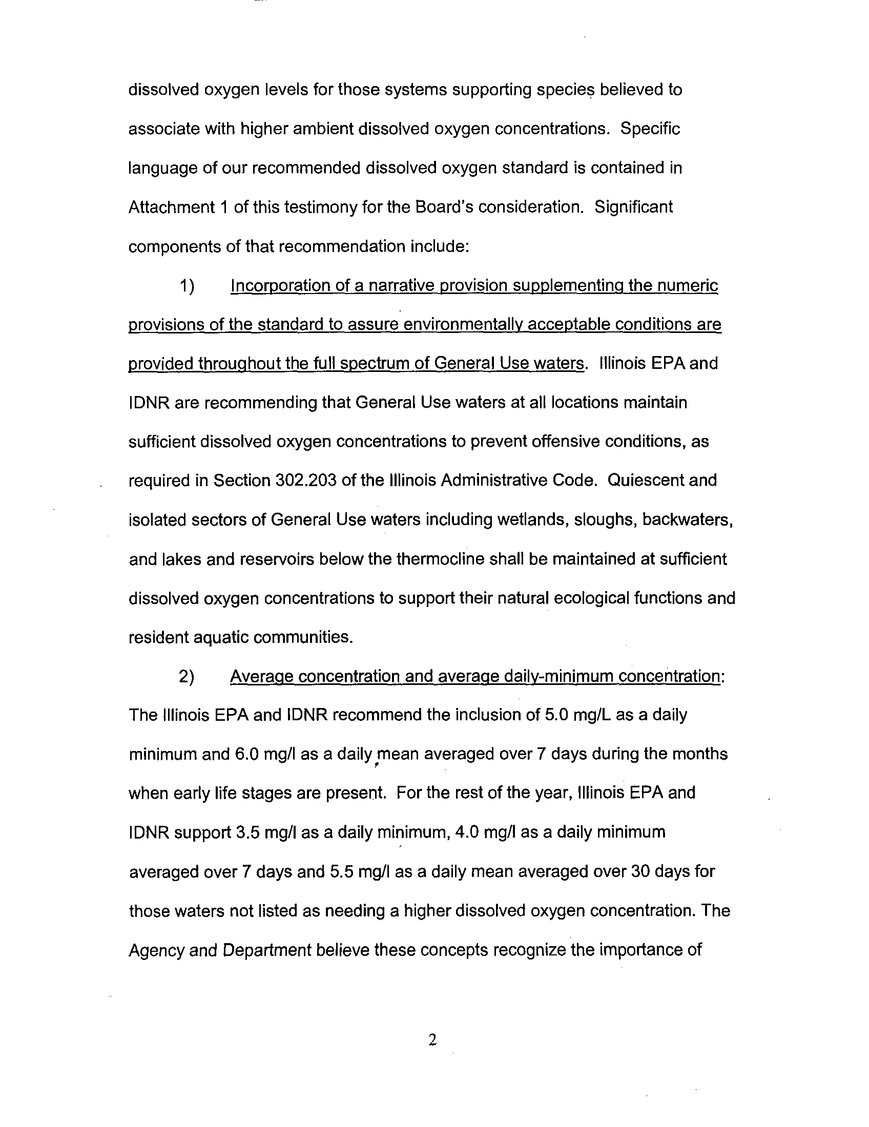
Our recommendation to the Board establishes a two leveled dissolved
oxygen standard . Level One is a base condition patterned after the structure
recommended in USEPA's National Criteria document and generally protective of
a full and diverse aquatic community. Level Two sets incrementally higher
1
dissolved oxygen levels for those systems supporting species believed to
associate with higher ambient dissolved oxygen concentrations . Specific
language of our recommended dissolved oxygen standard is contained in
Attachment 1 of this testimony for the Board's consideration . Significant
components of that recommendation include :
1)
Incorporation of a narrative provision supplementinq the numeric
provisions of the standard to assure environmentally acceptable conditions are
provided throuqhout the full spectrum of General Use waters . Illinois EPA and
IDNR are recommending that General Use waters at all locations maintain
sufficient dissolved oxygen concentrations to prevent offensive conditions, as
required in Section 302 .203 of the Illinois Administrative Code . Quiescent and
isolated sectors of General Use waters including wetlands, sloughs, backwaters,
and lakes and reservoirs below the thermocline shall be maintained at sufficient
dissolved oxygen concentrations to support their natural ecological functions and
resident aquatic communities .
2)
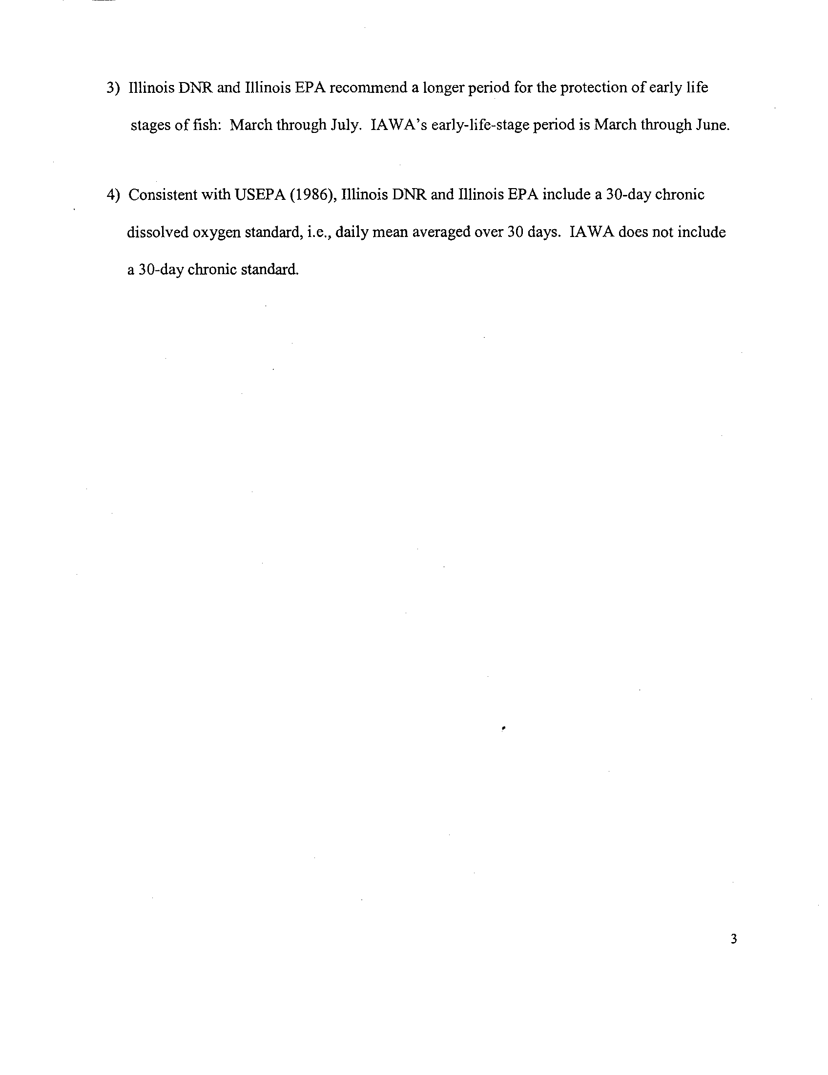
Average concentration and averaqe daily-minimum concentration :
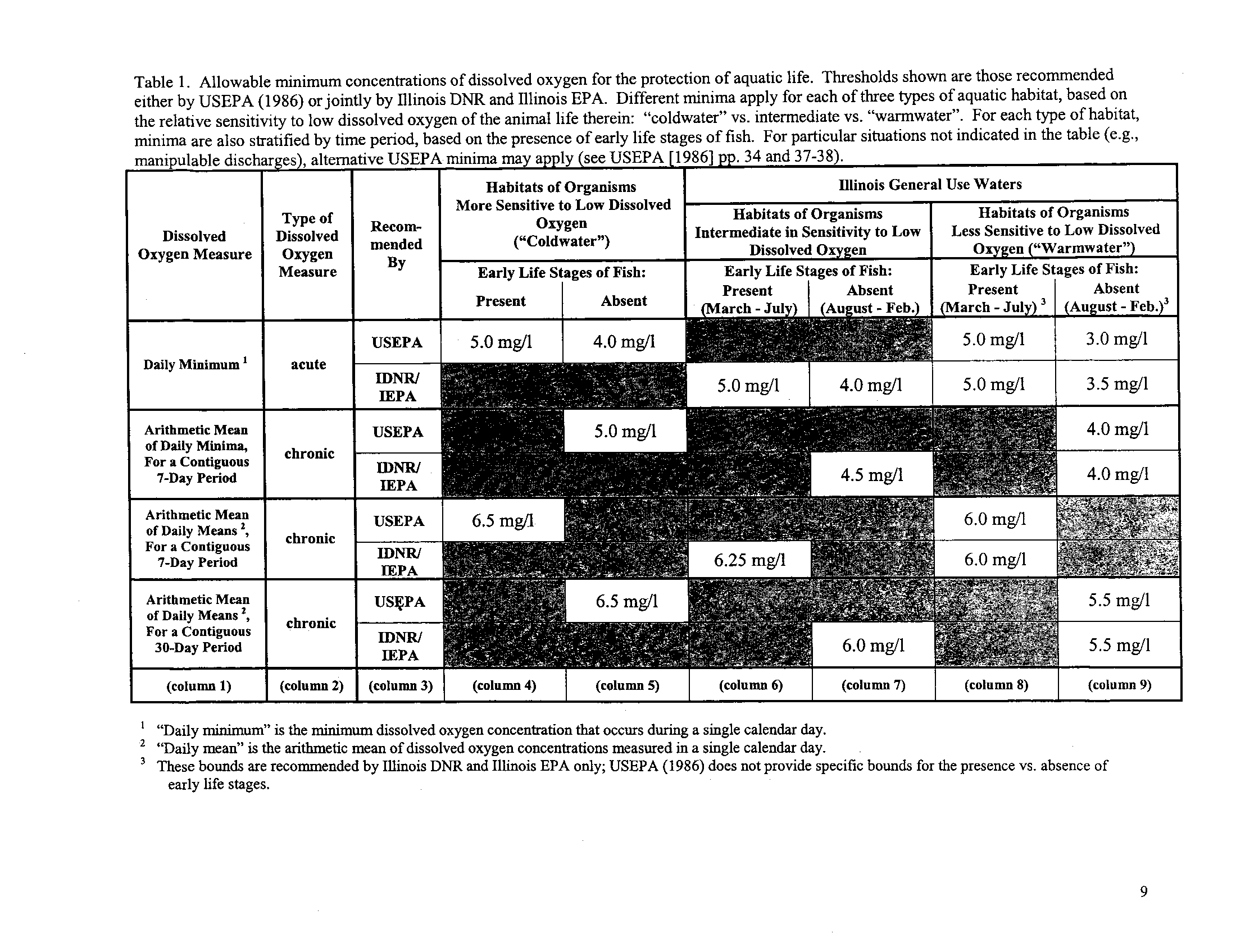
The Illinois EPA and IDNR recommend the inclusion of 5 .0 mg/L as a daily
minimum and 6.0 mg/I as a daily mean averaged over 7 days during the months
when early life stages are present
. For the rest of the year, Illinois EPA and
IDNR support 3.5 mg/I as a daily minimum, 4.0 mg/I as a daily minimum
averaged over 7 days and 5.5 mg/I as a daily mean averaged over 30 days for
those waters not listed as needing a higher dissolved oxygen concentration . The
Agency and Department believe these concepts recognize the importance of
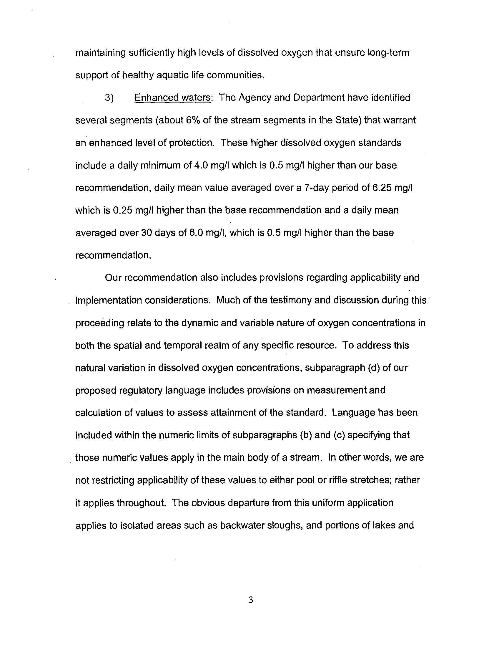
maintaining sufficiently high levels of dissolved oxygen that ensure long-term
support of healthy aquatic life communities .
3)
Enhanced waters: The Agency and Department have identified
several segments (about 6% of the stream segments in the State) that warrant
an enhanced level of protection . These higher dissolved oxygen standards
include a daily minimum of 4.0 mg/I which is 0.5 mg/I higher than our base
recommendation, daily mean value averaged over a 7-day period of 6
.25 mg/I
which is 0 .25 mg/I higher than the base recommendation and a daily mean
averaged over 30 days of 6
.0 mg/I, which is 0.5 mg/I higher than the base
recommendation.
Our recommendation also includes provisions regarding applicability and
implementation considerations . Much of the testimony and discussion during this
proceeding relate to the dynamic and variable nature of oxygen concentrations in
both the spatial and temporal realm of any specific resource . To address this
natural variation in dissolved oxygen concentrations, subparagraph (d) of our
proposed regulatory language includes provisions on measurement and
calculation of values to assess attainment of the standard . Language has been
included within the numeric limits of subparagraphs (b) and (c) specifying that
those numeric values apply in the main body of a stream . In other words, we are
not restricting applicability of these values to either pool or riffle stretches ; rather
it applies throughout . The obvious departure from this uniform application
applies to isolated areas such as backwater sloughs, and portions of lakes and
3
reservoirs below the thermocline, where lower oxygen concentrations can be
expected to occur naturally .
Finally, I would again like to thank the Board for the opportunity to submit
pre-filed testimony and I would be happy to answer any of the Board's questions
at the conclusion of the presentation of testimony from the Agency and the
Department .
4
Toby Frevert~ve
ATTACHMENT
1
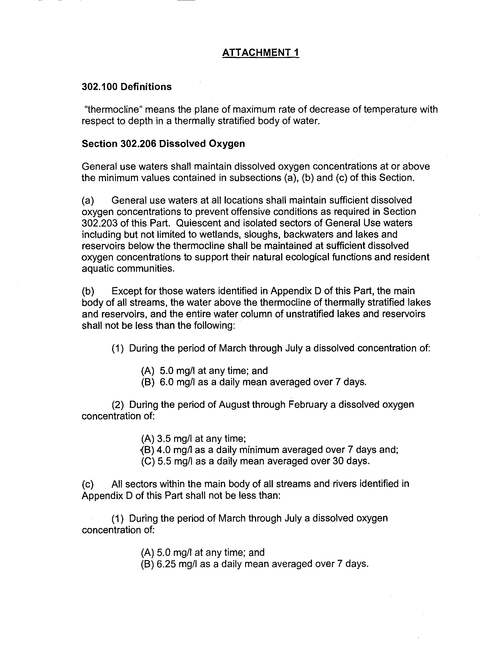
302.100 Definitions
"thermocline" means the plane of maximum rate of decrease of temperature with
respect to depth in a thermally stratified body of water .
Section 302.206 Dissolved Oxygen
General use waters shall maintain dissolved oxygen concentrations at or above
the minimum values contained in subsections (a), (b) and (c) of this Section .
(a)
General use waters at all locations shall maintain sufficient dissolved
oxygen concentrations to prevent offensive conditions as required in Section
302 .203 of this Part . Quiescent and isolated sectors of General Use waters
including but not limited to wetlands, sloughs, backwaters and lakes and
reservoirs below the thermocline shall be maintained at sufficient dissolved
oxygen concentrations to support their natural ecological functions and resident
aquatic communities .
(b)
Except for those waters identified in Appendix D of this Part, the main
body of all streams, the water above the thermocline of thermally stratified lakes
and reservoirs, and the entire water column of unstratified lakes and reservoirs
shall not be less than the following :
(1) During the period of March through July a dissolved concentration of:
(A) 5.0 mg/I at any time ; and
(B) 6.0 mg/I as a daily mean averaged over 7 days.
(2) During the period of August through February a dissolved oxygen
concentration of :
(A) 3.5 mg/I at any time;
<B) 4.0 mg/i as a daily minimum averaged over 7 days and ;
(C) 5.5 mg/I as a daily mean averaged over 30 days
.
(c)
All sectors within the main body of all streams and rivers identified in
Appendix D of this Part shall not be less than :
(1) During the period of March through July a dissolved oxygen
concentration of :
(A) 5.0 mg/I at any time ; and
(B) 6.25 mg/I as a daily mean averaged over 7 days .
ATTACHMENT 1
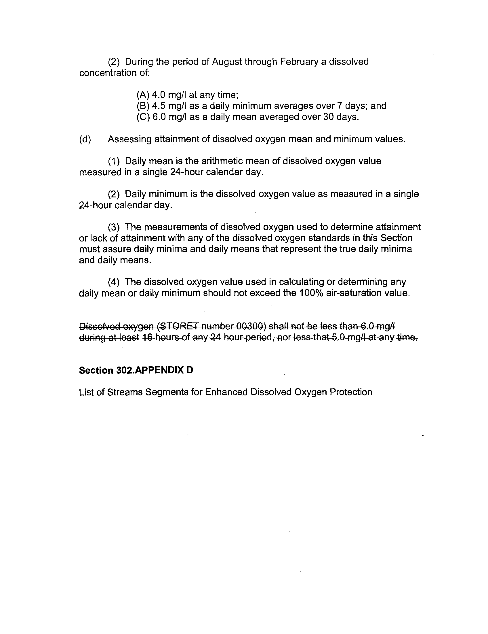
(2) During the period of August through February a dissolved
concentration of:
(A) 4.0 mg/I at any time;
(B) 4.5 mg/I as a daily minimum averages over 7 days ; and
(C) 6.0 mg/I as a daily mean averaged over 30 days .
(d)
Assessing attainment of dissolved oxygen mean and minimum values .
(1) Daily mean is the arithmetic mean of dissolved oxygen value
measured in a single 24-hour calendar day .
(2) Daily minimum is the dissolved oxygen value as measured in a single
24-hour calendar day .
(3) The measurements of dissolved oxygen used to determine attainment
or lack of attainment with any off the dissolved oxygen standards in this Section
must assure daily minima and daily means that represent the true daily minima
and daily means .
(4) The dissolved oxygen value used in calculating or determining any
daily mean or daily minimum should not exceed the 100% air-saturation value .
01sGelved oxygen (ST-OR T number 00300) chaff not be ioee than 6 .0 mg/I
Section 302 .APPENDIX D
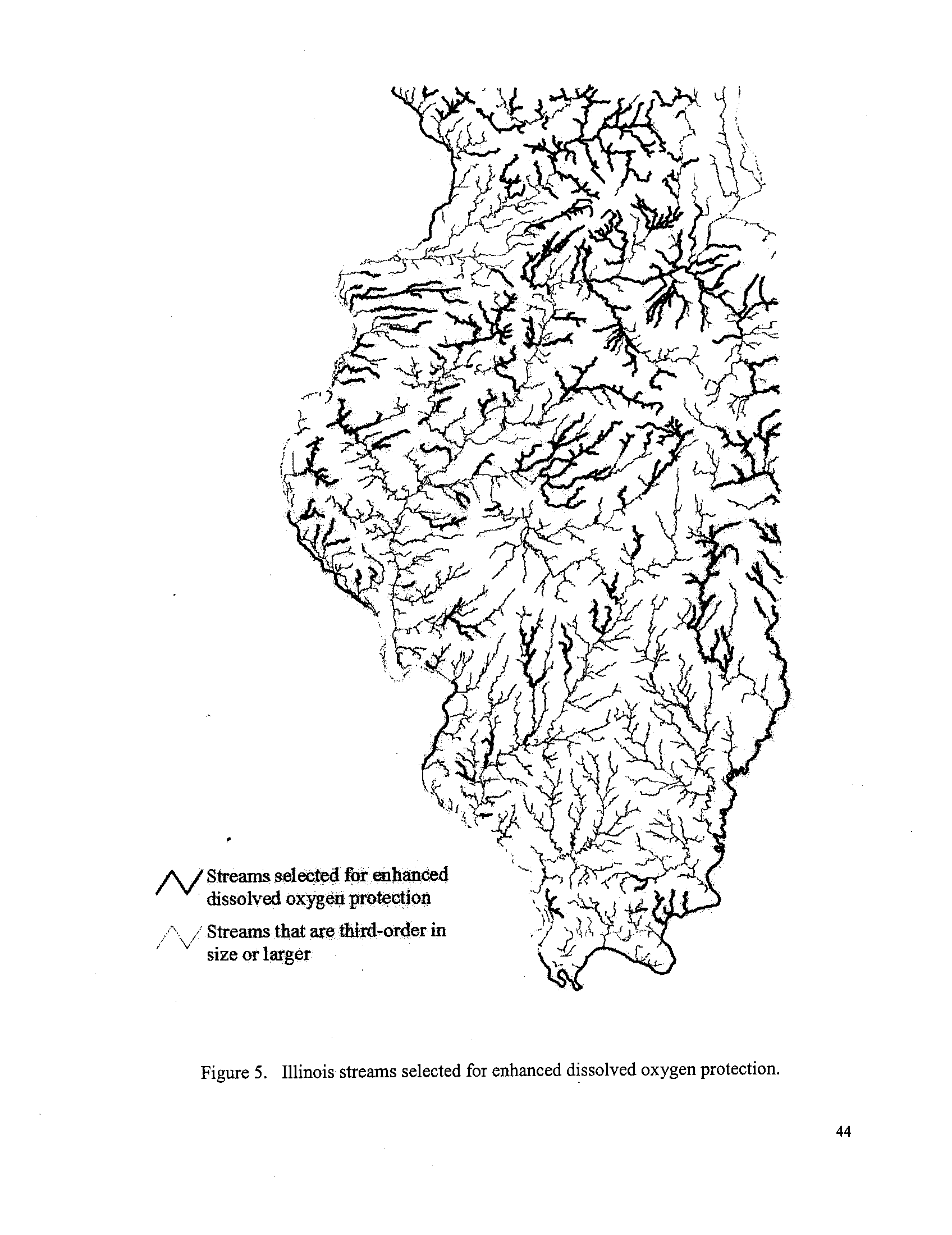
List of Streams Segments for Enhanced Dissolved Oxygen Protection
BEFORE THE ILLINOIS POLLUTION CONTROL BOARD
IN THE MATTER OF :
)
PROPOSED AMENDMENTS TO
)
R04-25
DISSOLVED OXYGEN STANDARD
)
35 III . Adm . Code 302 .206
)
REC
,EI VED
APR 0 4 2005
Pollution
STATE OF
Control
ILLINOIS
Board
PRE-FILED TESTIMONY OF ROY SMOGOR
Good morning . My name is Roy Smogor
; I have been employed by the Illinois
Environmental Protection Agency ("Illinois EPA") for about 6 years
. I am a stream
biologist with a Master of Science degree in Fisheries and Wildlife Sciences from
Virginia Polytechnic Institute and State University
. I also have a Bachelor of Science
degree in Biology from University of Illinois at Champaign-Urbana
. I have several years
of experience, in the states of Virginia and Illinois, in developing ways to use information
about fish and other aquatic life to determine the overall condition, or health, of streams
.
Currently I am a Public Service Administrator in the Surface Water Section of the
Bureau of Water
. The Surface Water Section is responsible for monitoring the resource
quality of Illinois streams and lakes
. Specifically, we collect biological, chemical, and
physical information from waters throughout the state and then interpret and report on
this information
. Our activities help guide the protection, management, and regulation
of Illinois' aquatic natural resources
. My pre-filed testimony in this matter provides an
overview of the Technical Support Document that explains the joint recommendations,
of Illinois EPA and the Illinois Department of Natural Resources ("Illinois DNR"), for the
General Use water quality standard for dissolved oxygen
.
Since the August 2005 Board hearing in this matter, Illinois EPA has participated
in developing a final joint recommendation in response to proposed changes in the
dissolved oxygen water quality standard made by the Illinois Association of Wastewater
Agencies ("IAWA")
. Illinois EPA believes the current dissolved oxygen standard for
Illinois General Use waters is too simplistic
. The current standard inadequately
accounts for the varied dissolved oxygen requirements of aquatic life in these waters
.
Moreover, the current standard does not account for how dissolved oxygen
concentrations vary across a broad range of natural aquatic conditions in Illinois
.
The revisions to the current dissolved oxygen General Use water quality
standard being recommended today by Illinois EPA and Illinois DNR are based primarily
on the U . S
. Environmental Protection Agency's (U .S.
EPA) 1986 national-criteria
document for dissolved oxygen
. Illinois EPA and Illinois DNR used this 1986 document
as a foundation from which to interpret and incorporate more-recent information
specifically applicable to the dissolved oxygen needs of aquatic life in Illinois waters
.
Although revisions to the current dissolved oxygen standard proposed by IAWA in April
2004 are also based on U .S
. EPA's national-criteria document, Illinois EPA's
recommendations differ from those of IAWA in the four following ways
:
1) Illinois EPA recommends two levels of numeric standards, with an enhanced level of
protection for waters inhabited by organisms especially sensitive to low dissolved
oxygen levels
. For a small subset of General Use waters-about 8% of the total
General Use stream miles-Illinois EPA recommends a higher level of dissolved oxygen
protection than proposed by IAWA
. This higher level is intermediate between the
"coldwater" criteria and 'warmwater' criteria recommended in U
.S . USEPA's national-
criteria document
. Some Illinois waters require dissolved oxygen levels higher than
U.S
. EPA's "warmwater" criteria because of the presence of a meaningful amount of fish
or macro invertebrates that are more sensitive to low dissolved oxygen than the
relatively few organisms on which U .S EPA's "warmwater" criteria are primarily based .
2) Illinois EPA recommends a narrative dissolved oxygen standard for waters that
naturally cannot achieve consistently higher levels of dissolved oxygen, such as
wetlands, sloughs, river backwaters, and portions of lakes and reservoirs below the
thermocline.
3) Ilinois EPA recommends an annual period one month longer than that proposed by
IAWA for the protection of sensitive life stages of fish . Namely, March through July
rather than March through June .
4) Consistent with the U .S . EPA national-criteria document, Illinois EPA recommends a
30-day chronic dissolved oxygen standard in the form of a daily mean averaged over 30
days
; this 30-day mean is not included in the IAWA proposal .
These recommendations are reflected in the language filed with the Board as
Attachment 1 to the Pre-Filed testimony of Toby Frevert
.
I participated in several aspects of the development of the Technical Support
Document and joint Illinois EPA and Illinois DNR recommendations in this proceeding .
Also, I am Illinois EPA's primary author for the joint Technical Support Document that
was pre-filed with the Board with this testimony
. In January 2006, I talked (with Edward
T
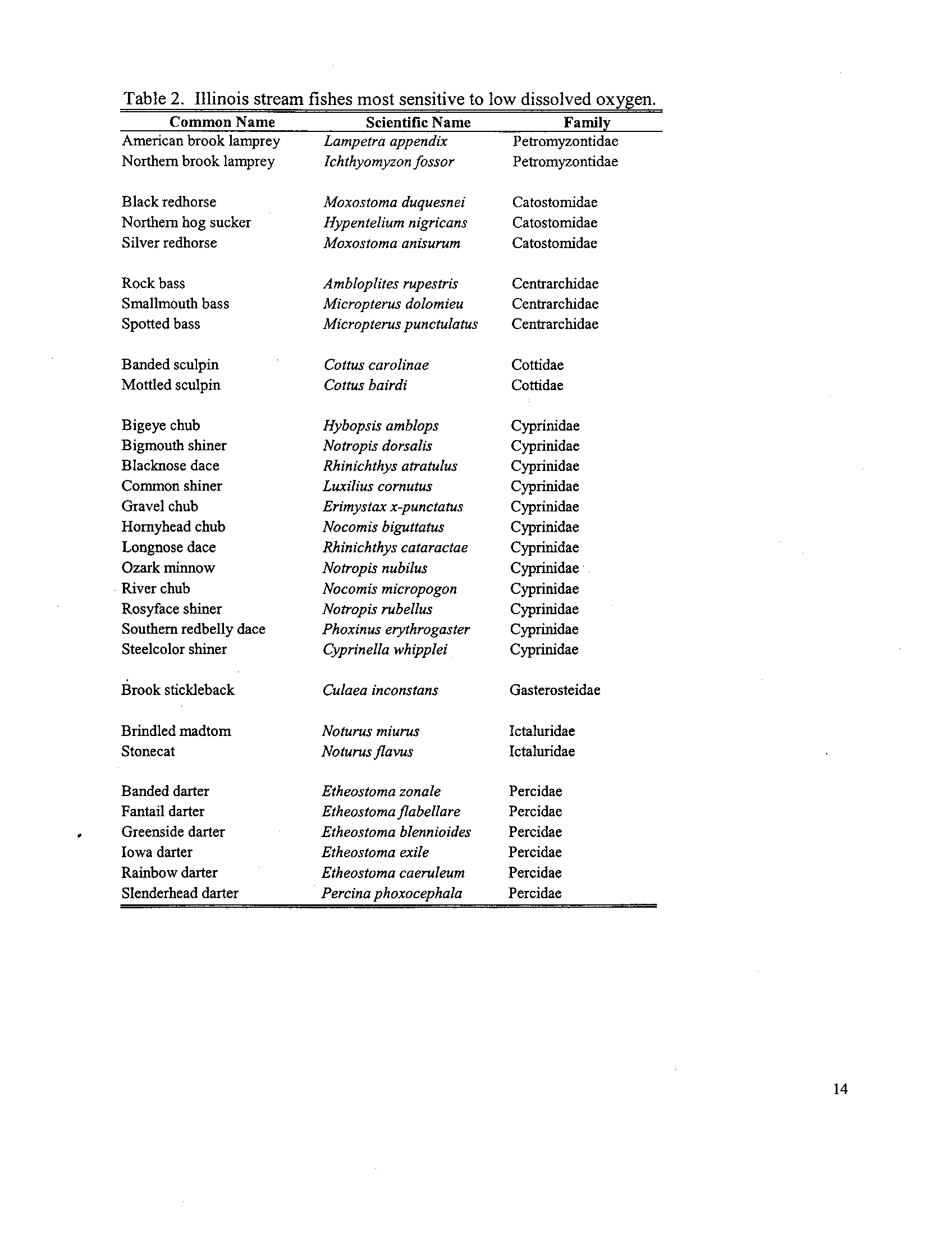
. Rankin about his research on relations between stream fishes and dissolved oxygen
in Ohio
. We discussed how Illinois EPA and Illinois DNR were using his results to help
identify Illinois fish species that are especially sensitive to low dissolved oxygen and
thus potentially deserving of higher dissolved oxygen standards
. I worked with Illinois
EPA and Illinois DNR biologists and natural-resource managers to determine how to
identify which streams in Illinois need higher minimum dissolved oxygen concentrations
than those represented by the U .S . EPA "warmwater" criteria
. After the two agencies
co-developed an approach, Illinois DNR took the lead in identifying the Illinois stream-
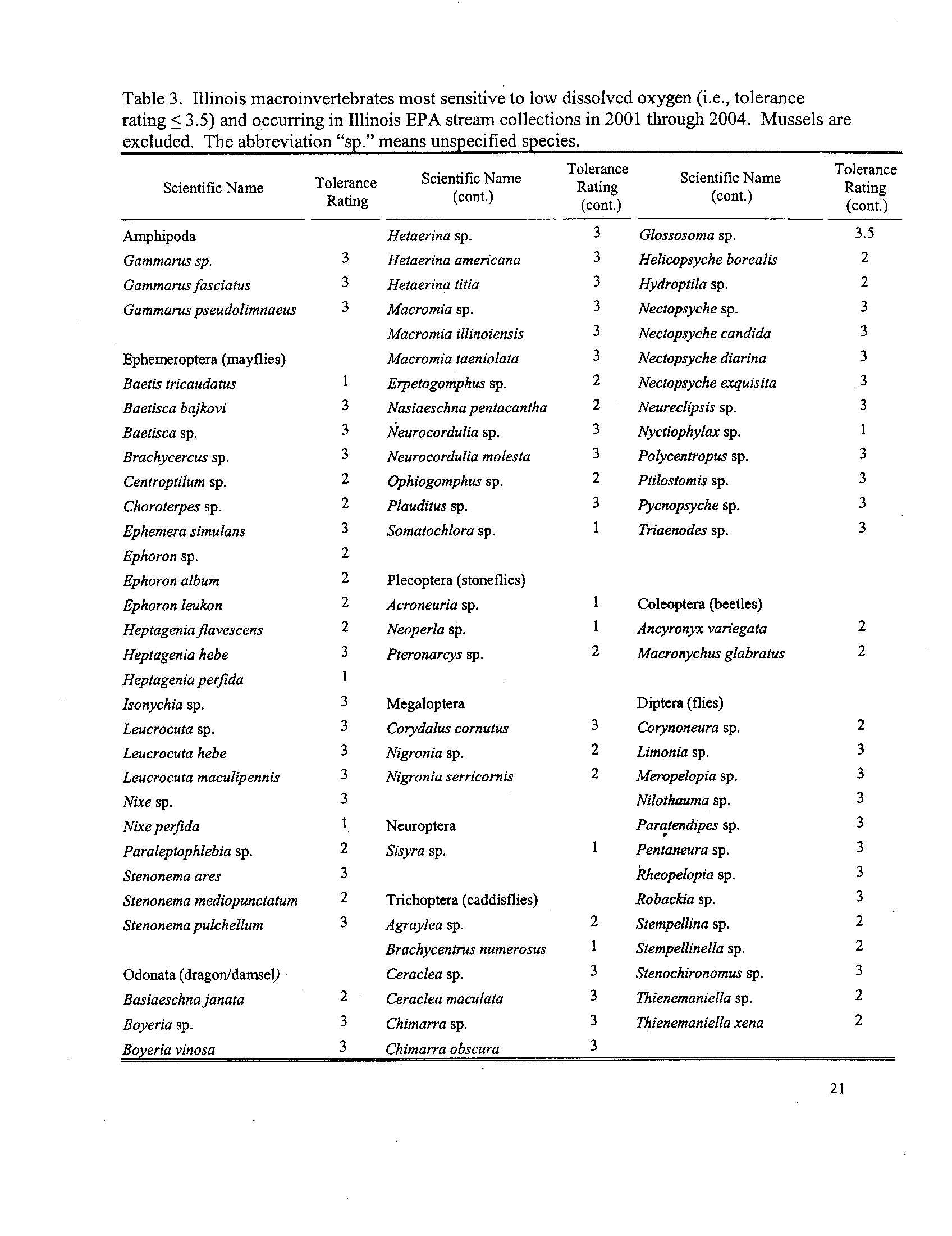
fish and mussel species that are most sensitive to low dissolved oxygen . Illinois EPA
led the effort to determine an analogous list of most-sensitive stream
macroinvertebrates, excluding mussels . After the two agencies analyzed biological
information to determine which stream sites had meaningful amounts of sensitive
organisms, I extrapolated this site-specific information to identify the stream segments
that require the higher recommended level of dissolved oxygen standards . I am
available to answer questions about or to provide examples of this extrapolation
process.
Illinois EPA and Illinois DNR collaborated extensively to develop the technical
scientific basis and to perform the analyses that culminated in the joint recommended
revisions to the dissolved oxygen standard . The experience and expertise of several
Illinois natural-resource managers and biologists were invaluable to this process . In
addition to Illinois DNR colleagues, the following Illinois EPA staff provided valuable
technical input : Matt Short, Mark Joseph, Howard Essig, Gregg Good, Bob Mosher,
and Toby Frevert . Matt Short is also available to answer questions about how the
Illinois EPA macroinvertebrate information was used or about Illinois EPA's stream
monitoring program, in general . In addition to relying on Illinois-based expertise, the
Technical Support Document cites several published scientific books and papers;
copies of the relvant portions of these works can be provided as necessary .
Illinois EPA believes that these recommendations to the Board are scientifically
sound and defensible in light of the currently available information on the dissolved
oxygen needs of aquatic life in Illinois . Inevitably, in the future, additional information
will become available that will allow Illinois EPA to evaluate and possibly improve these
current recommendations to the Board .
Finally, I would like to thank the Board for the opportunity to provide this pre-filed
testimony and the accompanying Technical Support Document . Illinois EPA hopes this
document sheds some light on the varied dissolved oxygen needs of Illinois aquatic life
and helps the Board in its determination in this difficult proceeding . I will be happy to
answer questions from the Board at the conclusion of the presentation of testimony from
the Agency and the Department .
April 3, 2006
Illinois Environmental Protection Agency
1021 North Grand Avenue East
P.O. Box 19276
Springfield, Illinois 62794-9276
By: Roy
Smogor~
RECEpv
ID
BEFORE THE ILLINOIS POLLUTION CONTROL BOARD
APR 0 4 20?,5
STATE OF ILLINOIS
IN THE MATTER OF
:
Pollution Control
j
Board
PROPOSED AMENDMENTS TO
)
R 04-25
DISSOLVED OXYGEN STANDARD
)
(Rulemaking
-
Water)
35 ILL.
ADM. CODE 302
.206
)
PRE-FILED TESTIMONY OF JOEL CROSS
My name is Joel Cross and I have been employed by the Illinois Department of
Natural Resources (Illinois DNR) for 7 and one half years
. I am currently the Acting
Manager of the Watershed Protection Section within the Office of Resource
Conservation
. The Watershed Protection Section has the responsibility of coordinating
the implementation of the Illinois Wildlife Action Plan, statewide watershed-based
scientific investigations, and Geographical Information Systems for the Office of Resource
Conservation
. I was formerly employed by the Illinois Environmental Protection Agency
(Illinois EPA) for 19 years
. During my last 9 years at the Illinois EPA, I was the Manager
of the Surface Water Section and the Planning Section in the Division of Water Pollution
Control
. My duties included daily administration of several water resource programs
including surface water monitoring and assessment, watershed management initiatives,
federal non-point source programs, federal and state clean lakes programs, Total
Maximum Daily Load (TMDL) development, Geographical Information Systems, and state
water quality standards programs
. I hold a Bachelor's degree in Zoology from Southern
Illinois University at Carbondale, Illinois
.
My testimony in this matter will include a general overview of the Illinois DNR's
role, contribution and background history in developing the Illinois DNR and Illinois EPA
joint recommendations for dissolved oxygen water quality standards
. A jointly written
Technical Support Document supplements the testimony provided by both Illinois DNR
and Illinois EPA, and provides detailed information regarding the two agencies
recommendations
. I will refer to the Technical Support Document throughout my
testimony
.
Since the August 25, 2005 hearing, the Illinois DNR and Illinois EPA jointly
developed a coordinated position that defines two levels of numeric standards for
dissolved oxygen . A fundamental aspect of this position is that dissolved oxygen profiles
naturally vary within general use waters throughout Illinois ; therefore a single uniform
standard is not appropriate given the available science today . Illinois DNR and Illinois
EPA propose the establishment of two levels of numeric standards for dissolved oxygen
for Illinois Pollution Control Board consideration : one level is generally protective of a full
and diverse aquatic community (identified as level 2 in the Technical Support Document),
and the other level sets incrementally higher dissolved oxygen concentrations to protect
Illinois' most sensitive types of aquatic life (identified as level 1 in the Technical Support
Document)
. The Illinois DNA became involved in this proceeding because State law
provides that Illinois owns all aquatic life within our state boundaries and the Illinois DNR
is specifically responsible for regulating and managing these natural resources
.
2
Illinois DNR and Illinois EPA established a process for identifying a subset of
waters that warrant an incrementally higher dissolved oxygen standard
. A general
description of this process follows . Our initial effort identified fish, macroinvertebrates,
and mussels that are sensitive to dissolved oxygen . Next, Illinois DNR and Illinois EPA
investigated fish and macroinvertebrate communities to determine four biological
measures: number of sensitive fish species, proportion of individual fish that are sensitive,
number of sensitive macroinvertebrate taxa, and the proportion of individual
macroinvertebrates. that are sensitive . Because the available mussel data did not
comprise community assessments, number of sensitive species and proportion of
sensitive individuals could not be calculated . The use of mussel data will be described
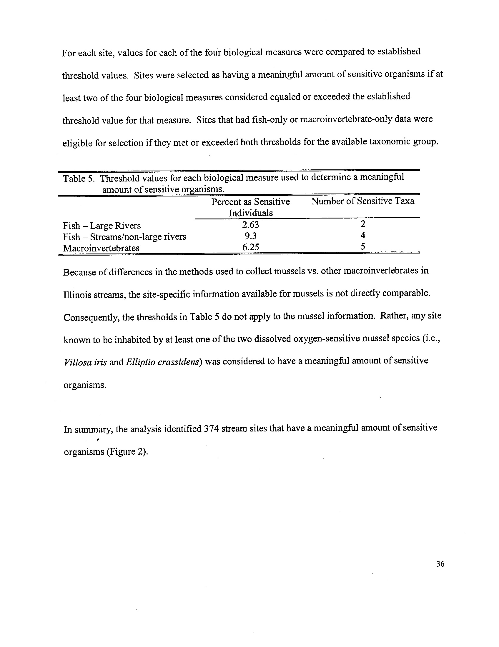
later in my testimony. The third step in our process was to identify a threshold value for
each of the four biological measures listed previously
. Illinois DNR and Illinois EPA
selected a threshold value that represented the typical amount known from healthy
streams. Threshold values for each of the biological measures were determined by
calculating the median value from sampling sites that were identified as attaining the
Clean Water Act goal for aquatic life, referred to as full support . The calculation of the
median was limited to full support waters in an attempt to limit the influence of
environmental stresses, including habitat and chemicals . The fourth step of the joint
process was to identify sites that had a meaningful amount of dissolved oxygen sensitive
organisms . For each site, values for each of the four biological measures were compared
3
to established threshold values . Sites were selected as having a meaningful amount of
sensitive organisms if at least two of the four biological measures considered equaled or
exceeded the established threshold value .
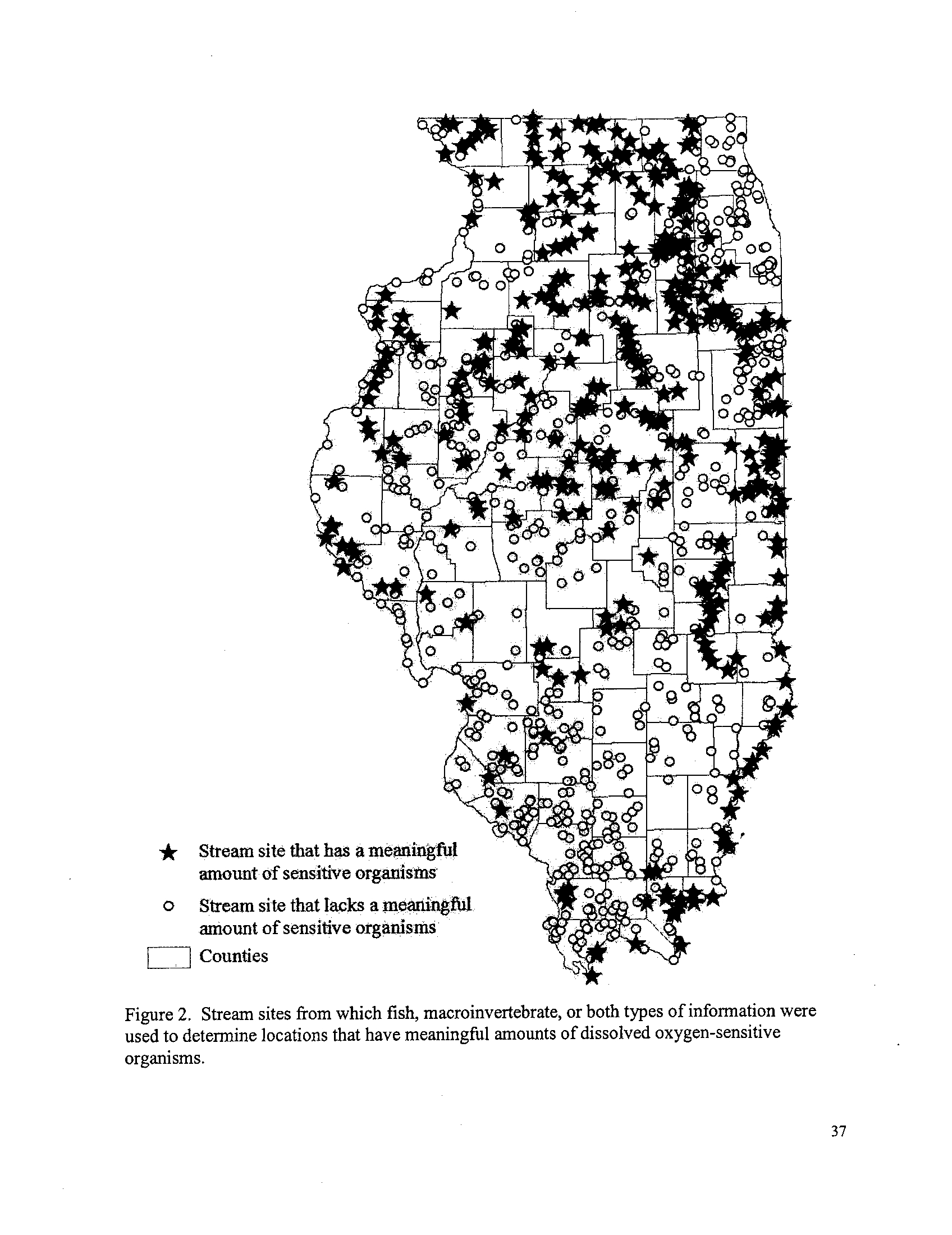
We had sampling results from 1,110 locations available for our analysis and
found that 374 of the total sampling sites were identified as candidates for enhanced
dissolved oxygen protection . Detailed information regarding the methods and
procedures, rationale, and supporting scientific literature used in the four-step process is
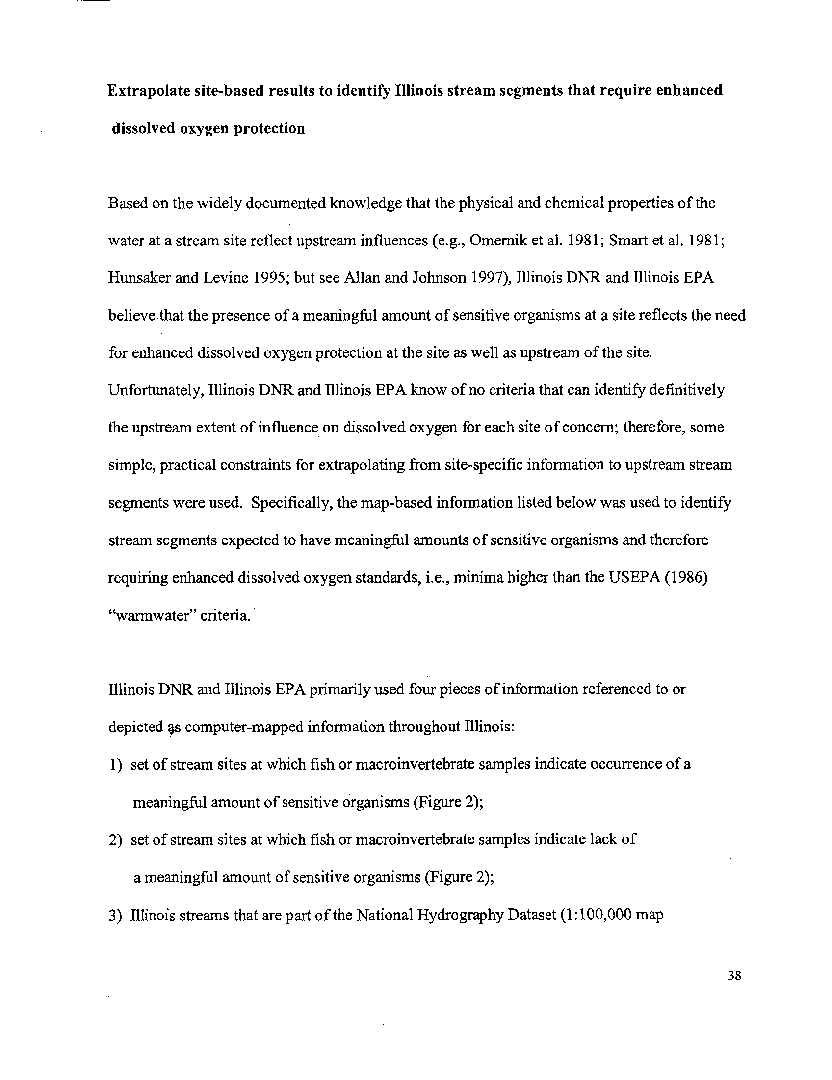
provided in the Technical Support Document on pages 33 through 37 . Having identified
these 374 sampling sites in need of enhanced dissolved oxygen protection, extrapolation
of these sites to stream segments was conducted . Detailed information regarding the
methods, procedures, and rationale for the extrapolation to stream segments is provided
in the Technical Support Document on pages 38 through 44 .
As mentioned previously, the number of sensitive species and proportion of
sensitive individuals could not be calculated for mussels because of limitations in
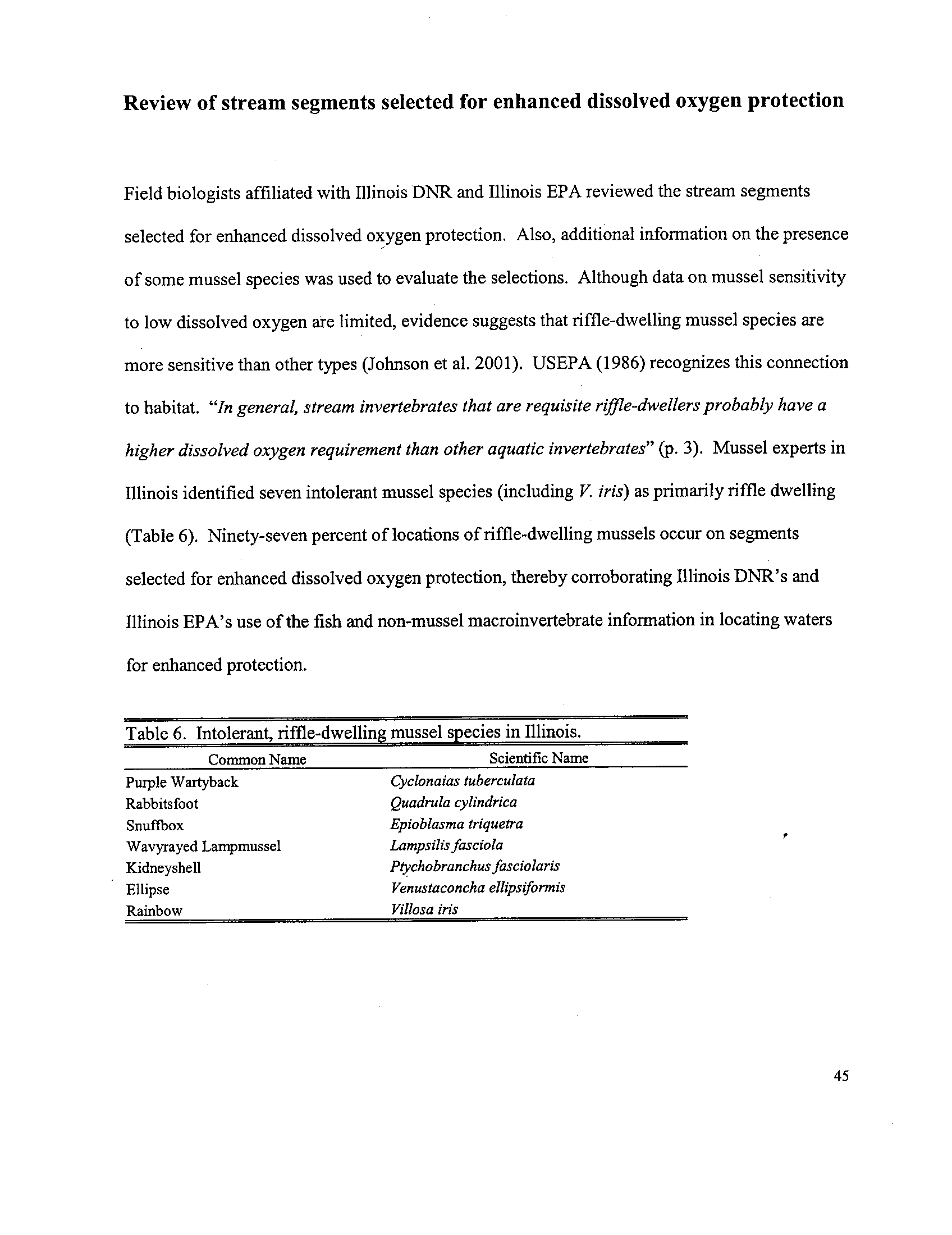
sampling methods . However, the locations of two sensitive mussel species were overlain
on the stream segments that were identified as needing an incrementally higher dissolved
oxygen standard based on fish and macroinvertebrate analysis . In essence, the mussel
data verified the effort to identify stream segments needing protection based on the fish
and macroinvertebrate data . Additional stream segments were selected for enhanced
protection for dissolved oxygen based on the presence of these two dissolved oxygen
4
sensitive mussels
. The list of stream segments, and the applicable dissolved oxygen
standards recommended, is described in the draft regulations provided by Toby Frevert,
Illinois EPA, pre-filed testimony attachment 1 . To facilitate the Illinois Pollution Control
Board and interested members of the public's review of identified stream segments in
need of incrementally higher dissolved oxygen standards, the Illinois DNR provided
geographically referenced data layers and associated software in compact disc format
(CD).
In addition to recommending two levels of numeric standards for dissolved
oxygen, the Illinois DNR and Illinois EPA are also recommending an additional 30-day
period as a statewide date (July 31) for protecting early life stages of fish
. This is in
contrast to the Illinois Association of Wastewater Agencies (IAWA's) recommended date
of June 30 . The Illinois DNR believes that, based on the scientific literature presented in
the Technical Support Document, an additional 30-day period is necessary to protect
early life stages of fish
. While the IAWA's proposed date of June 30 protects the majority
of spring season spawns, it neglects to include the spawning period of the summer
season spawns, and neglects to include a 30-day period for protection of post-hatch
embryonic and yolk-sac fry development
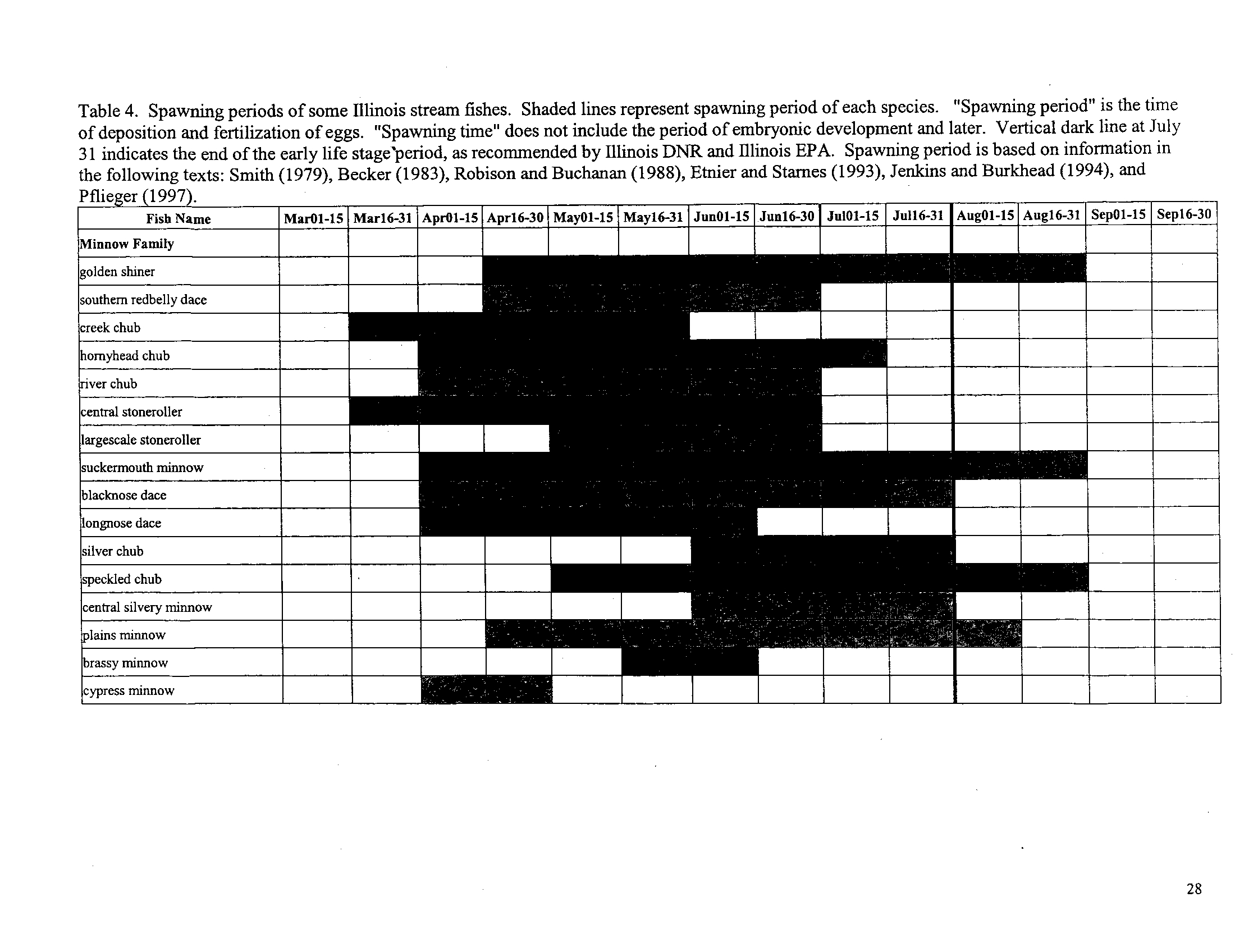
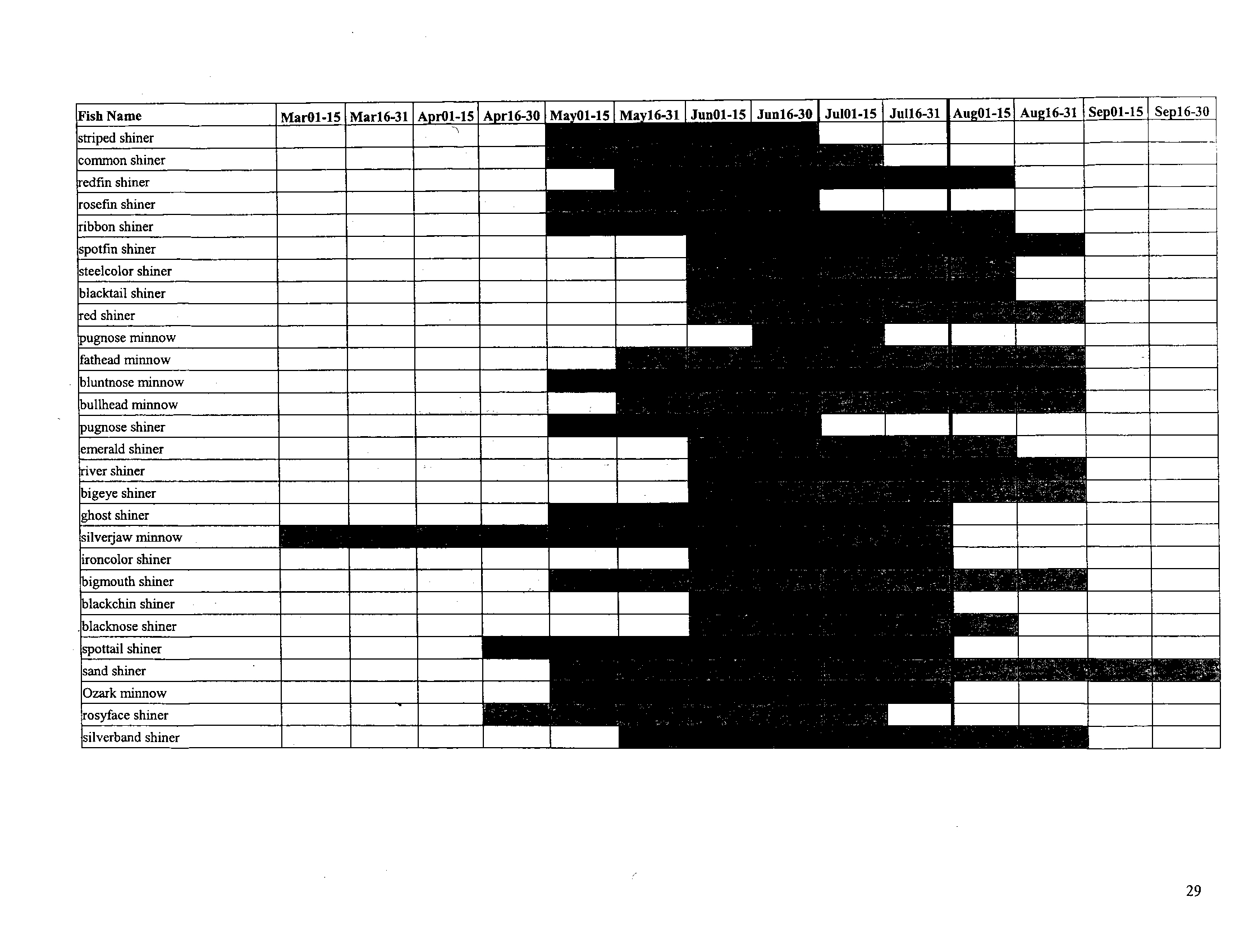
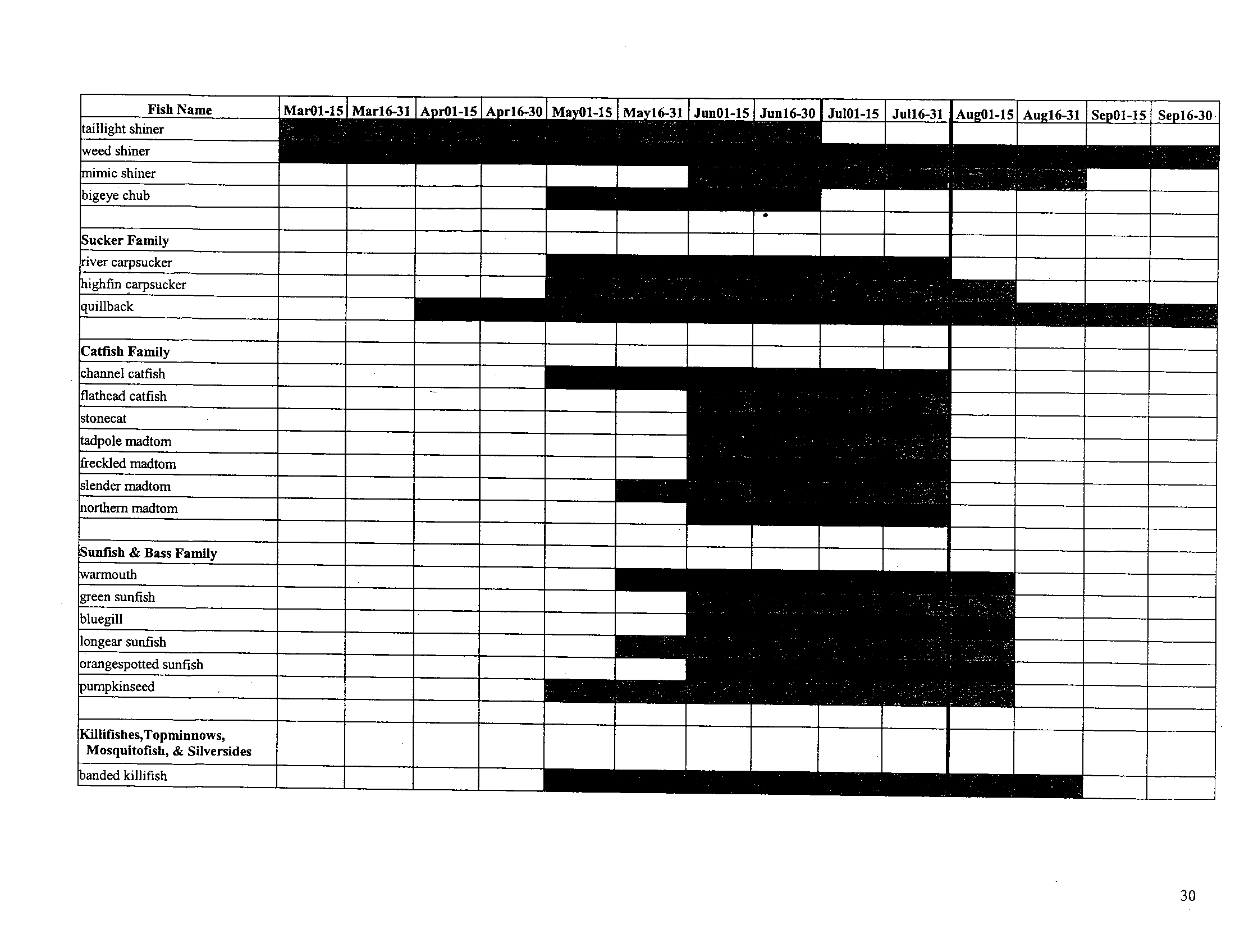
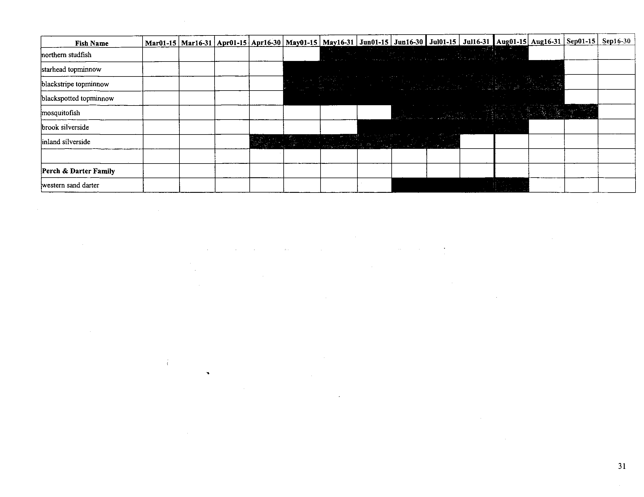
. In general, by July 31, all late spawning fish
species will have a substantial majority of their spawning and fry development into dates
when higher dissolved oxygen standards will be in effect . Even though some larvae will
5
be present into August, Illinois DNR fisheries managers believe the July 31 date should
not be detrimental to the overall recruitment of a year class for fish species . A full
discussion of the data supporting the selection of July 31 for protection of early life stages
is provided in the Technical Support Document on pages 23 through 31 .
The Illinois DNR and Illinois EPA developed these joint recommendations with
input from stakeholder groups . Scheduled stakeholder meetings were held on October
19, 2005 in Chicago, and November 15, 2005 in Springfield . These meetings were
attended by Illinois DNR, Illinois EPA, IAWA, Illinois Environmental Regulatory Group,
Sierra Club, Prairie Rivers Network, USEPA, and Friends of the Chicago River . The
Illinois DNR and Illinois EPA hosted additional meetings with IAWA on February 24, 2006
and with the Sierra Club and Prairie Rivers Network on March 1, 2006 . The stakeholder
process provided valuable input to the Illinois DNR and Illinois EPA in developing these
recommendations for dissolved oxygen standards .
The Illinois DNR believes these joint recommendations provided through
testimony and the Technical Support Document, significantly enhance protection for
aquatic life in comparison to the dissolved oxygen standard currently in place .
Specifically, these joint recommendations improve the current standard by identifying a
season that protects for early life stages of fishes, providing dissolved oxygen standards
more consistent with the-USEPA National Criteria Document for Dissolved Oxygen
6
(1986), and attempting to account for the seasonal and natural variability of dissolved
oxygen .
The Illinois DNR believes the two agencies recommendations build upon and
enhances the proposed amendments to the current dissolved oxygen standards
presented by IAWA by including two levels of numeric standards for protection of
identified dissolved oxygen sensitive organisms in Illinois ; a narrative standard for waters
that naturally cannot achieve consistently higher levels of dissolved oxygen such as
wetlands, sloughs, river backwaters, and lakes and reservoirs below the thermocline ; the
addition of the 30-day chronic standards consistent with the USEPA National Criteria
Document applicable to both levels of numeric standards for dissolved oxygen ; and an
additional 30-day period necessary to protect early life stages of fish
. The Illinois DNR
does not view these joint recommendations as a lowering of dissolved oxygen standards
within some waters during certain times of the year, but rather as focusing needed
protection for most sensitive types and life stages of aquatic life where required . At the
same time, the Illinois DNR and Illinois EPA recommendations are not unnecessarily over
protective elsewhere . Therefore, the Illinois DNR further believes these joint
recommendations will allow targeting of limited State resources to the most critical waters
impacted by low dissolved oxygen concentrations
.
Staff from the Illinois DNR has testified at both the August 12, 2004 and the
August 25, 2005 hearings . Testimony for the August 25, 2005 hearing was pre-filed by
7
Dr
. David L . Thomas, Chief of the Illinois Natural History Survey, on behalf of the Illinois
DNR. During that hearing, Mr
. Stanley Yonkauski, Illinois DNR attorney, moved to
withdraw the Illinois DNR pre-filed testimony in order to allow the development of a joint
position between Illinois DNR and Illinois EPA regarding dissolved oxygen standards (R
18-22)
. In addition, testimony was also provided by Dr
. Thomas during the August 12,
2004 hearing
. This Illinois DNR testimony, currently on the record, was provided in
response to a June 24, 2004 letter from the Lieutenant Governor's Office regarding
questions related to the dissolved oxygen issue (R 117-148, 155-158)
. Dr. Thomas'
testimony was provided in the form of a response letter to the Lieutenant Governor's
Office
. The Illinois DNR testimony of August 12, 2004 identified two issues regarding
dissolved oxygen that need to be referenced in context of the recommendations provided
by the Illinois DNR and Illinois EPA today
. Dr
. Thomas stated that "the one-day minimum
concentration of 3
.5 milligrams per liter and the seven-day mean minimum of 4
.0
milligrams per liter as not being conservative enough, and potentially endangering some
aquatic life in the state ." The 3
.5 and 4.0
milligrams per liter dissolved oxygen standards
proposed by IAWA are also, in part, contained in these joint recommendations provided
by Illinois DNR and Illinois EPA
. The Illinois DNR believes these joint recommendations
address Dr
. Thomas' concern expressed in previous Illinois DNR testimony by the
addition of two levels of numeric standards (described in the Technical Support Document
on pages 1 through 4)
. In these joint recommendations, the one-day minimum
8
concentration of 3 .5 milligram per liter and the seven-day mean minimum of 4 .0
milligrams per liter are applicable only to juvenile and adult life stages within level 2
waters. Applicable dissolved oxygen standards for juvenile and adult life stages in level 1
waters and for early life stages within both level 1 and 2 waters are incrementally higher
.
The second issue stated in previous Illinois DNR testimony identifies the need to maintain
a 5.0 milligrams per liter minimum at all times, which is consistent with the existing
dissolved oxygen standards . Dr. Thomas further stated "that there are species that
probably would not be protected at lower levels
." In developing these joint
recommendations, Illinois DNR and Illinois EPA investigated extensively dissolved
oxygen sensitivity to fish, macroinvertebrates, and mussels during various life stages
(described in the Technical Support Document on pages 10 through 22)
. Based on this
further scientific analysis, a 5 .0 milligram per liter acute dissolved oxygen standard is only
necessary for protection of early life stages within level 1 and 2 waters
. For juvenile and
adult life stages, protective acute dissolved oxygen standards include 4
.0 milligrams per
liter for level 1 waters and 3
.5 milligrams per liter for level 2 waters .
At this point, I would like to thank the Illinois Pollution Control Board for providing
the Illinois DNR and Illinois EPA additional time to develop a joint position in this matter
as well as all those people who fully participated in the stakeholder process
. Illinois DNR
staff making significant contributions to this process includes Scott Stuewe, Ann Holtrop,
Dr. David L . Thomas, Dr . Kevin Cummings, Jim Mick, Mike Conlin and Illinois DNR
9
Deputy Director Leslie Sgro . Staff from Illinois EPA spent countless hours working
directly with the Illinois DNR, including Toby Frevert, Roy Smogor, Matt Short, Mark
Joseph, Gregg Good, Bob Mosher, Stefanie Diers, Deborah Williams, and Marcia Willhite .
From the Sierra Club and Prairie Rivers Network, I'd like to thank Albert Ettinger, Cindy
Skrukrud, and Glynnis Collins . Finally, I'd like to thank IAWA, including Dennis Streicher,
Roy Harsh and Dr. James Garvey from Southern Illinois University .
In addition to myself, other Illinois DNR staff are here today and can be called
upon to address specific questions related to the Technical Support Document as
needed . Scott Stuewe, Acting Chief for the Division of Fisheries, can address questions
related to biological data and information . Ann Holtrop, Watershed Protection Section,
can address questions related to the overall process used to determine waters that
warrant a higher dissolved oxygen standard .
By Joel Cross, Acting Manager
Watershed Protection Section
Office of Resource Conservation
March 31, 2006
Joel Cross
-
Illinois Department of Natural Resources
One Natural Resources Way
Springfield, IL . 62702
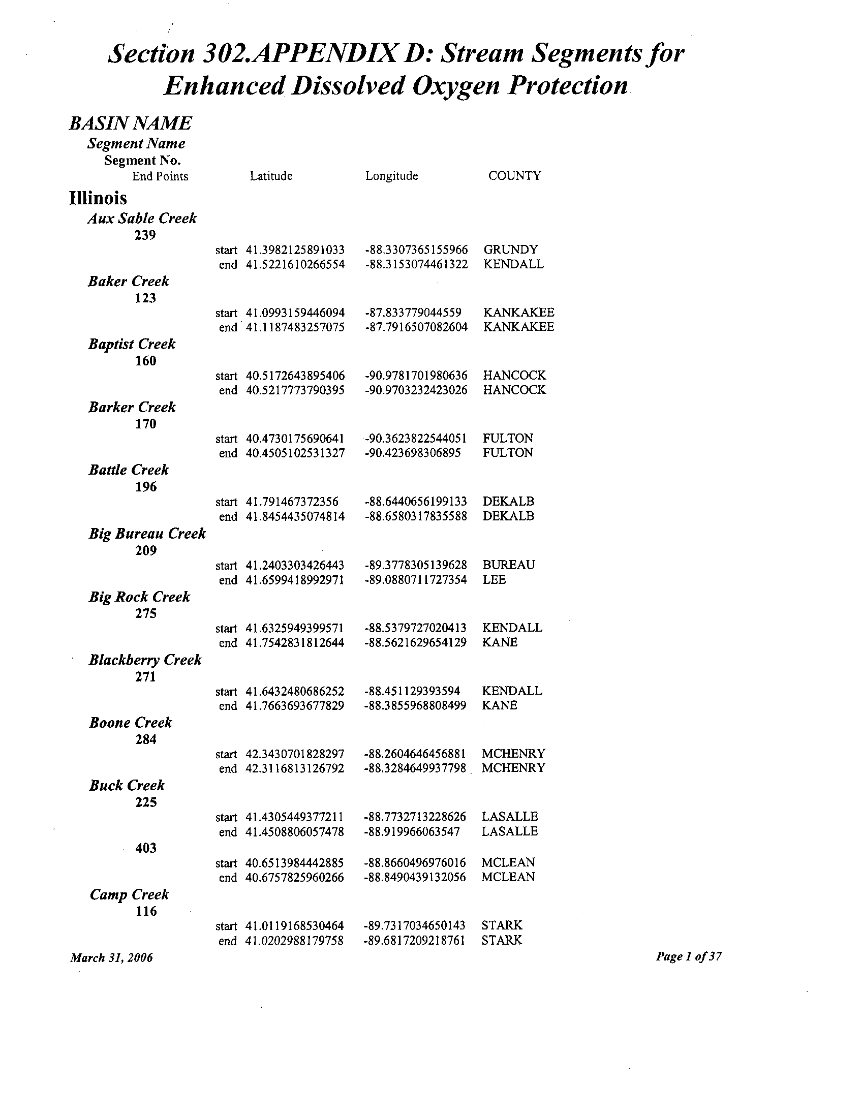
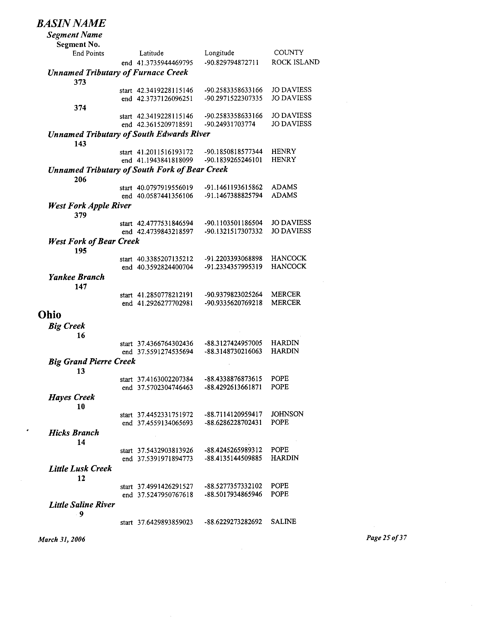
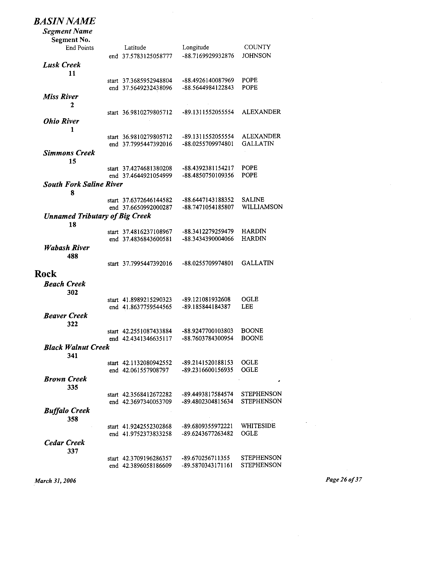
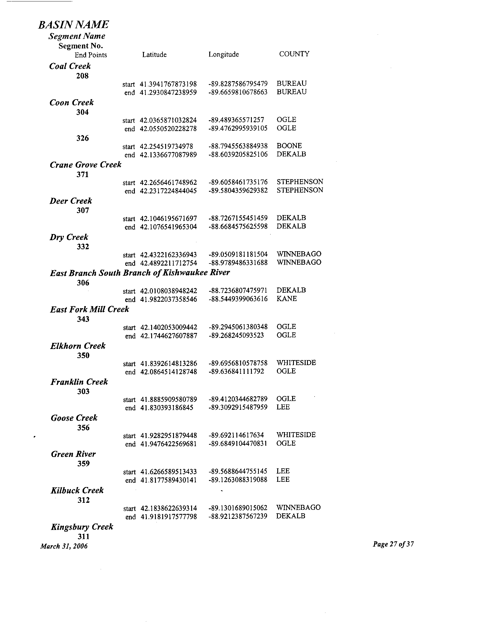
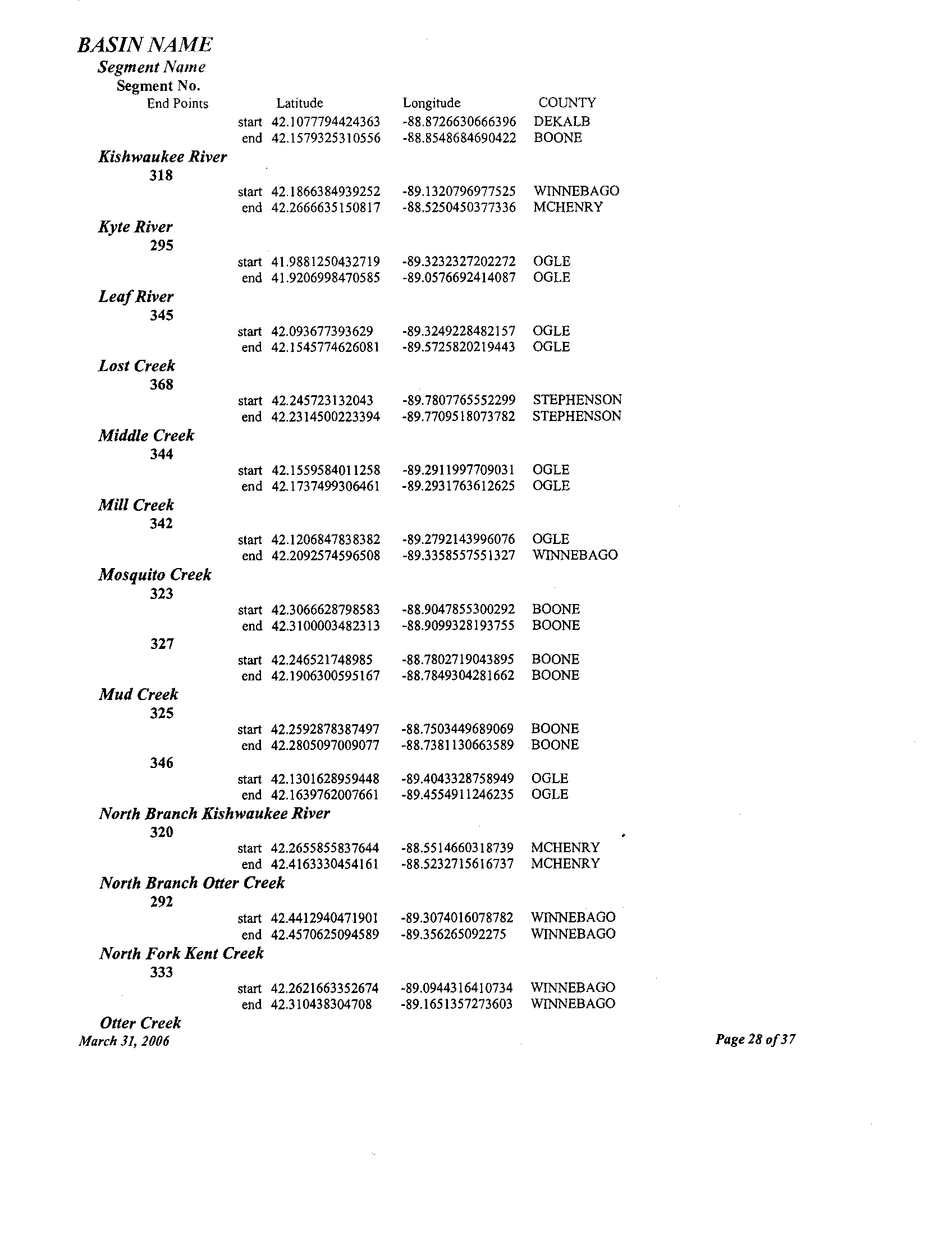
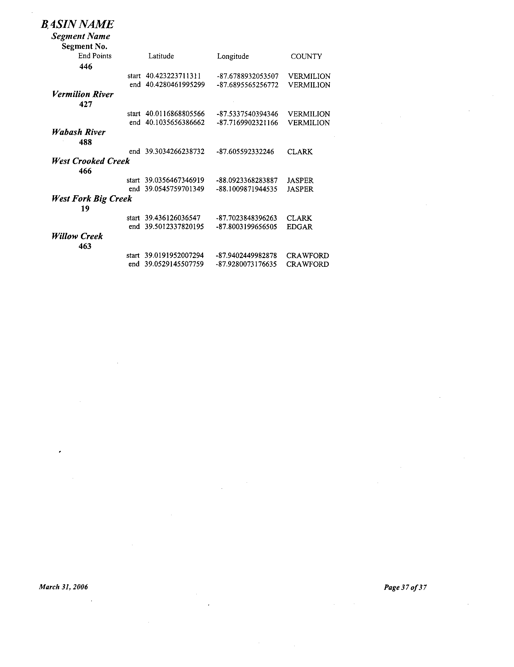
Section 302.APPENDIX D : Stream Segments or
Enhanced Dissolved Oxygen Protection
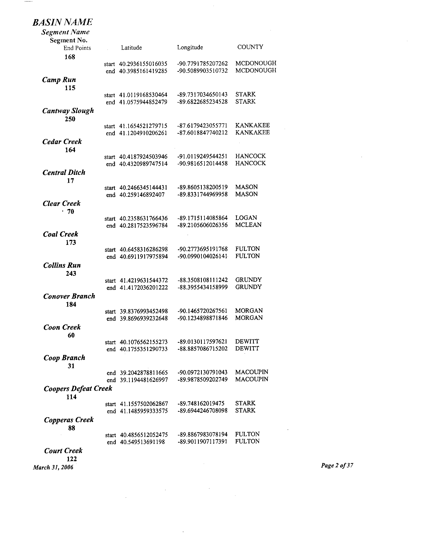
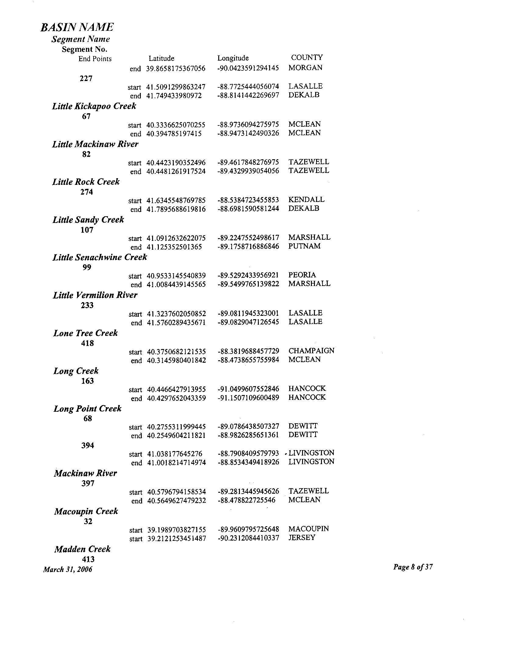
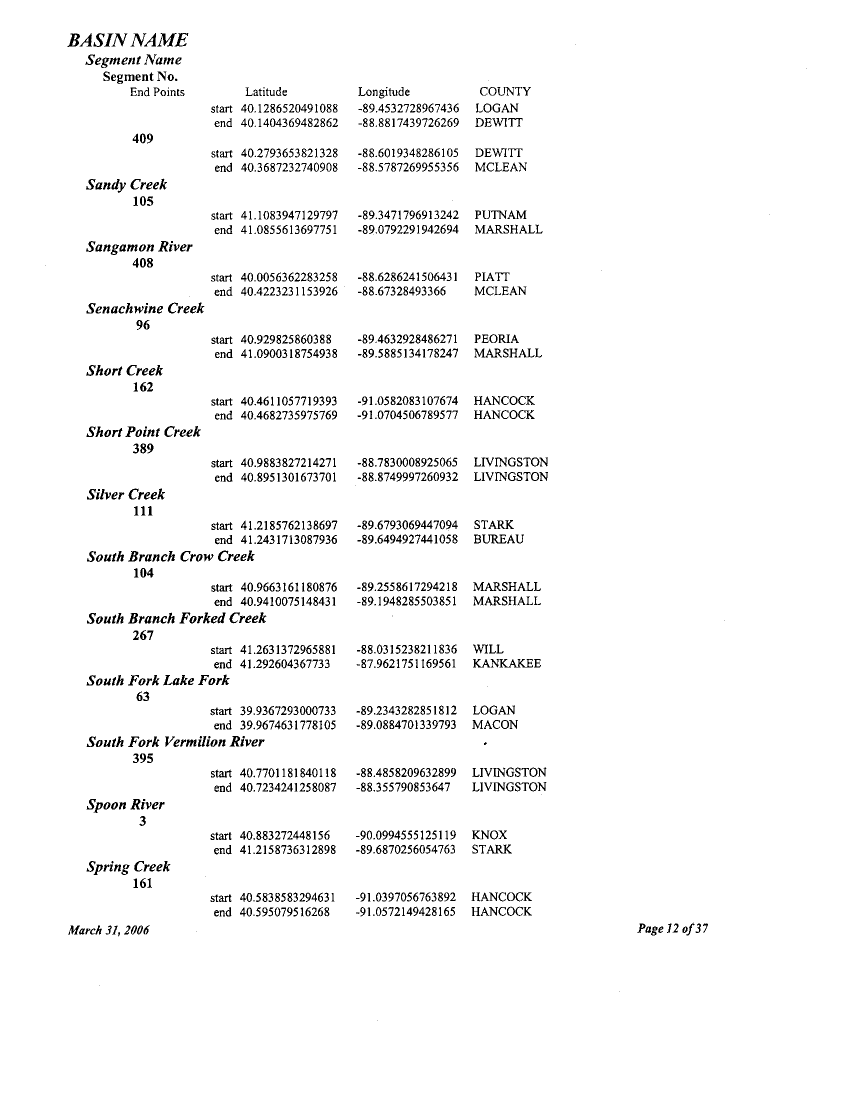
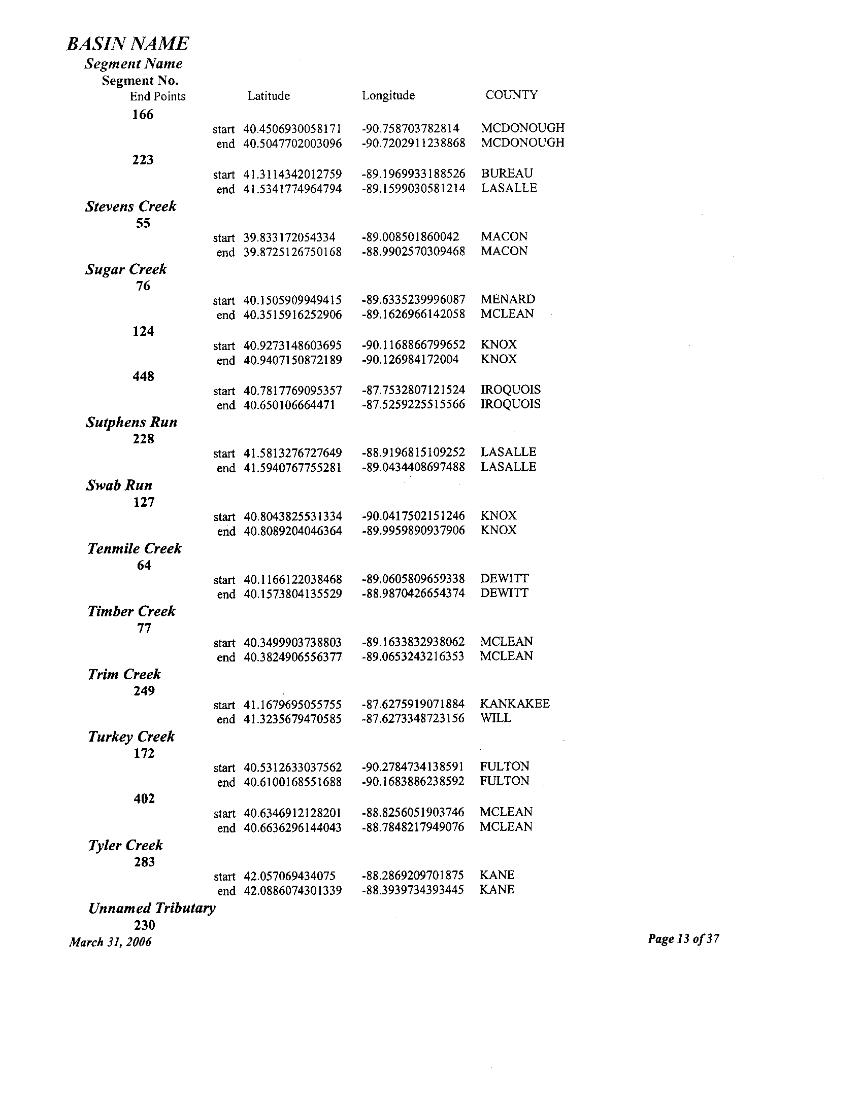
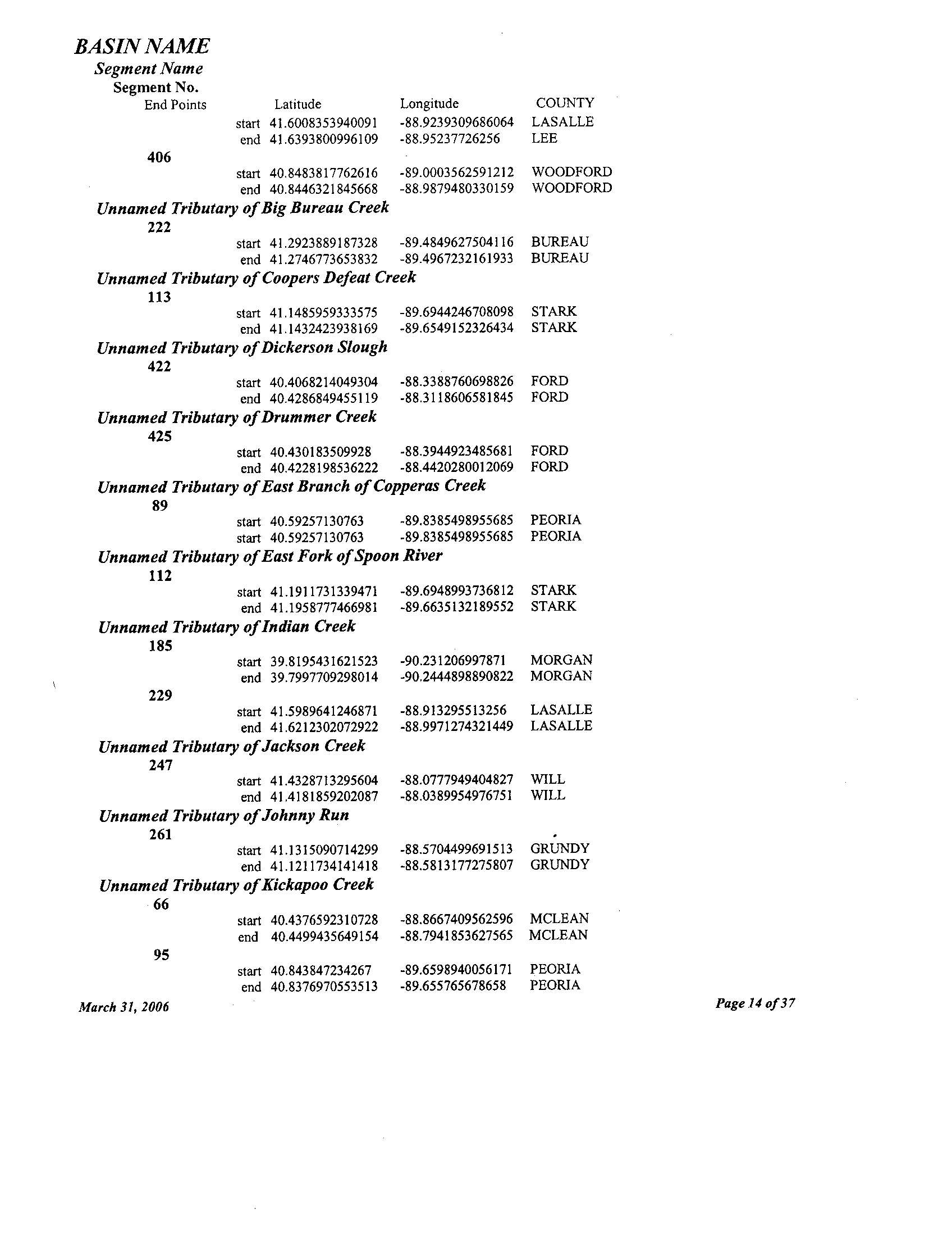
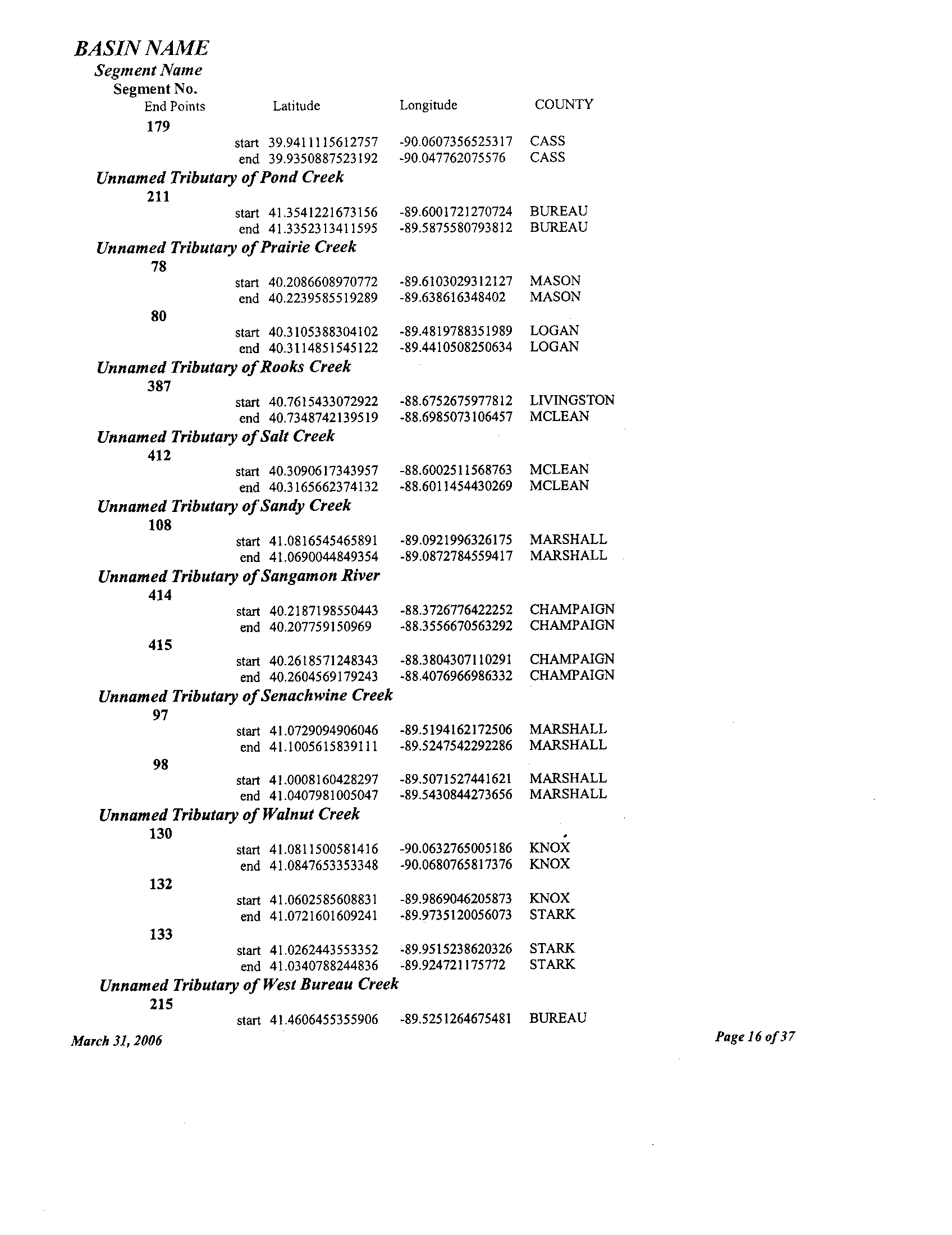
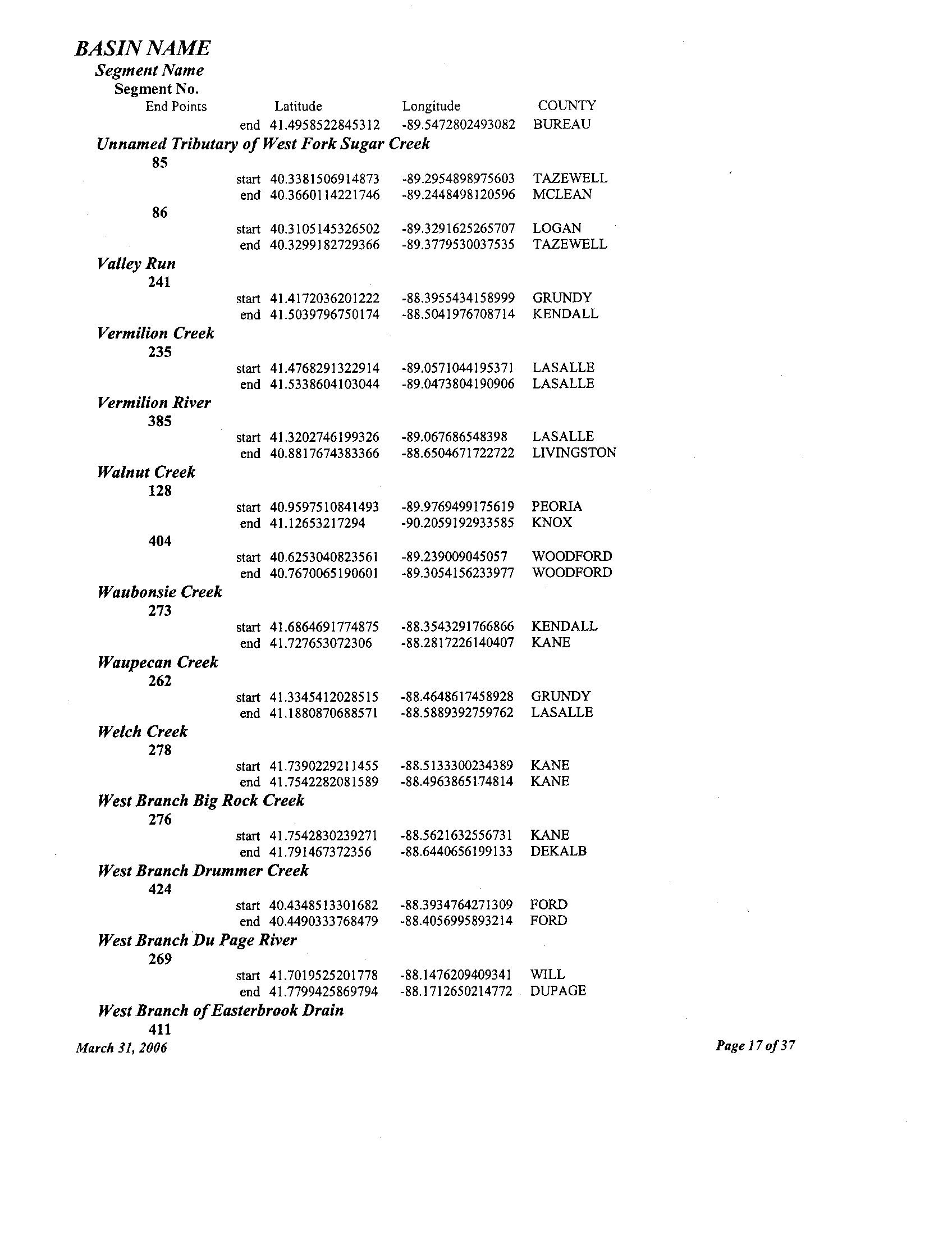
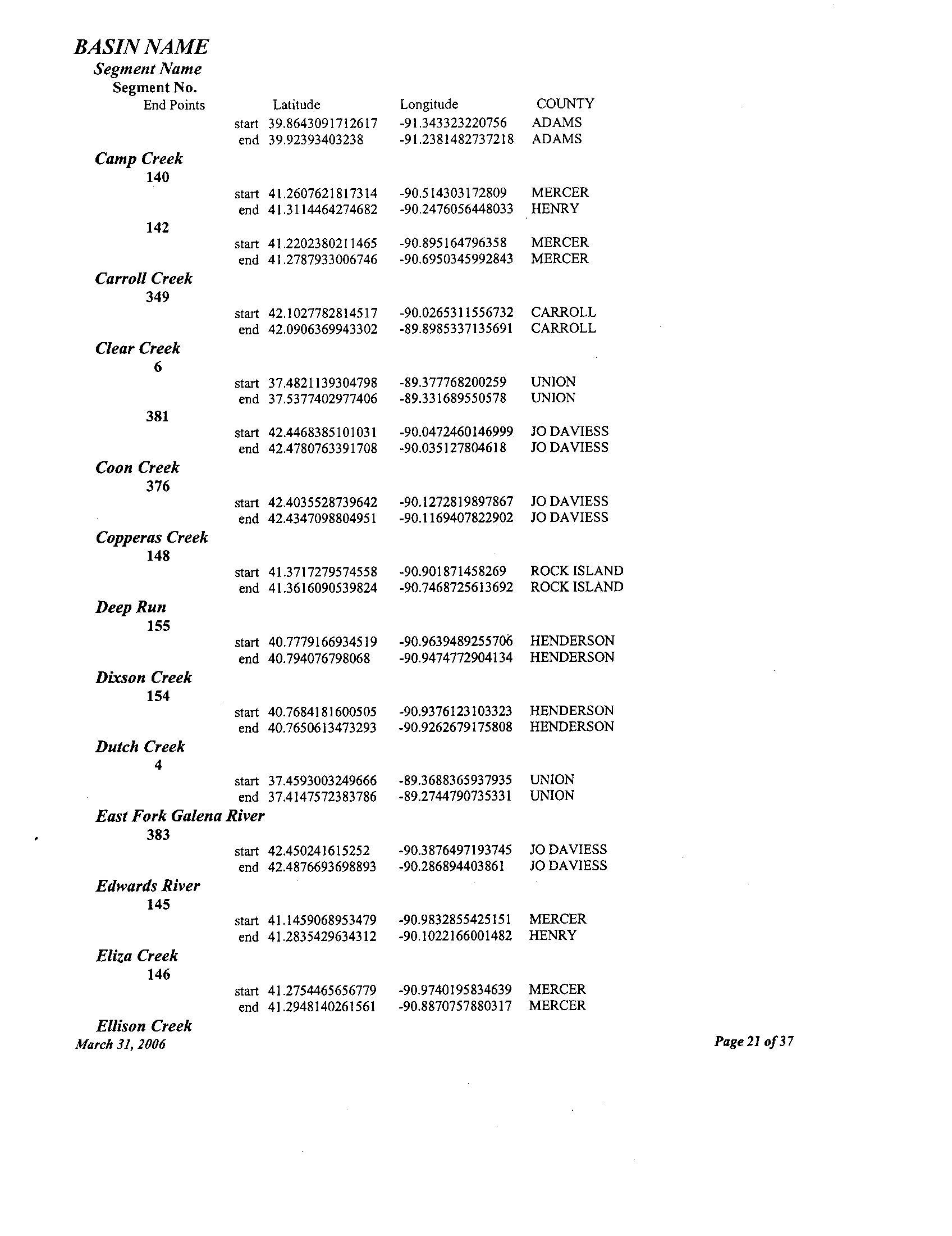
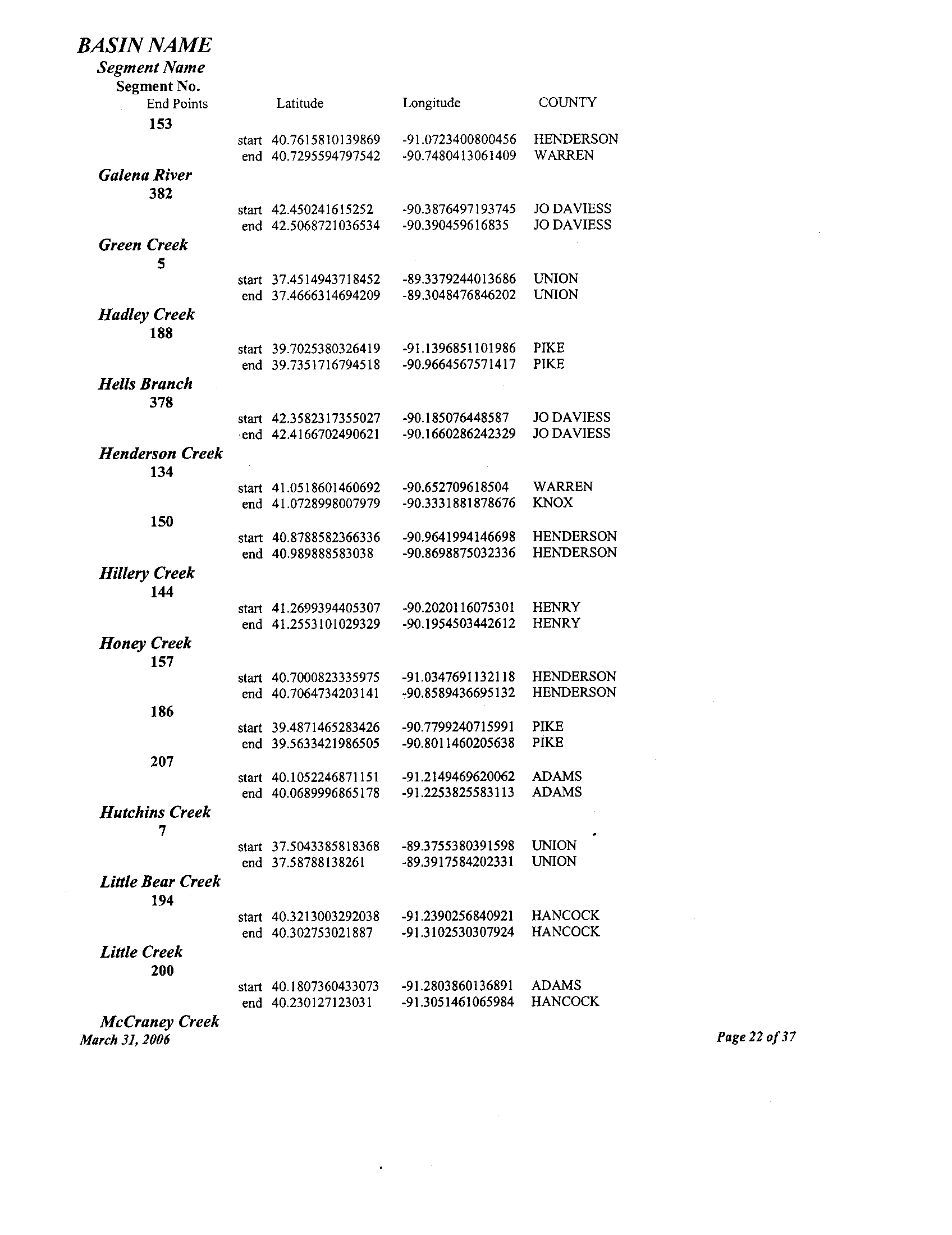
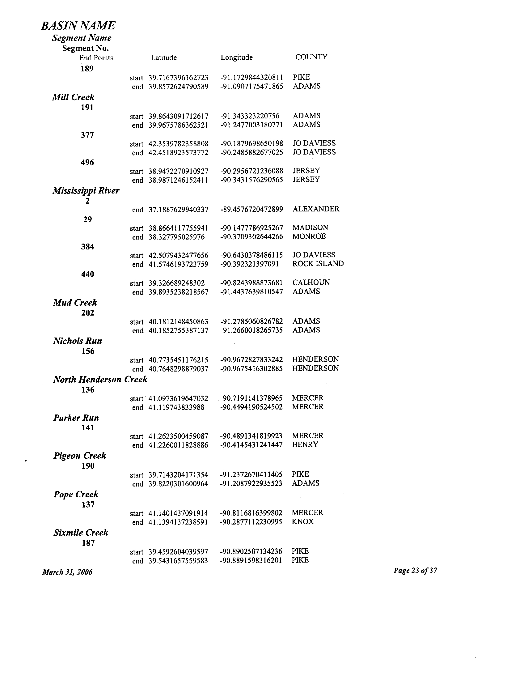
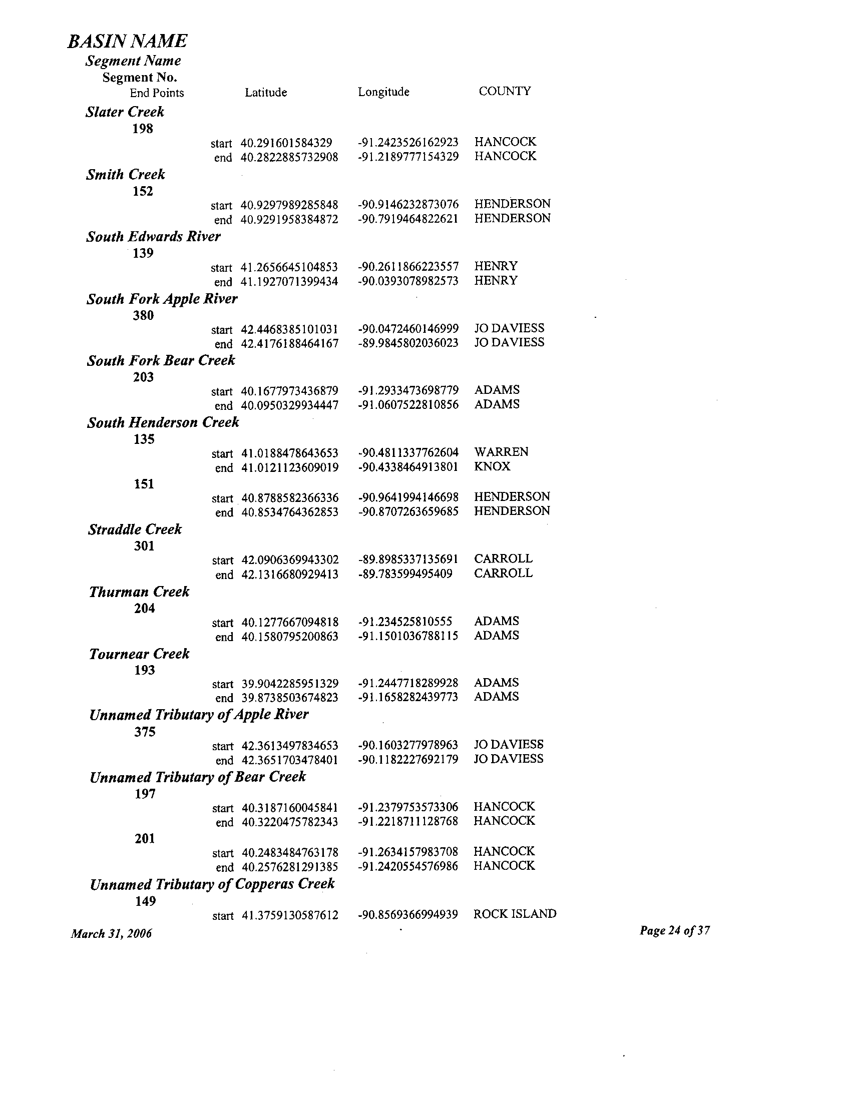
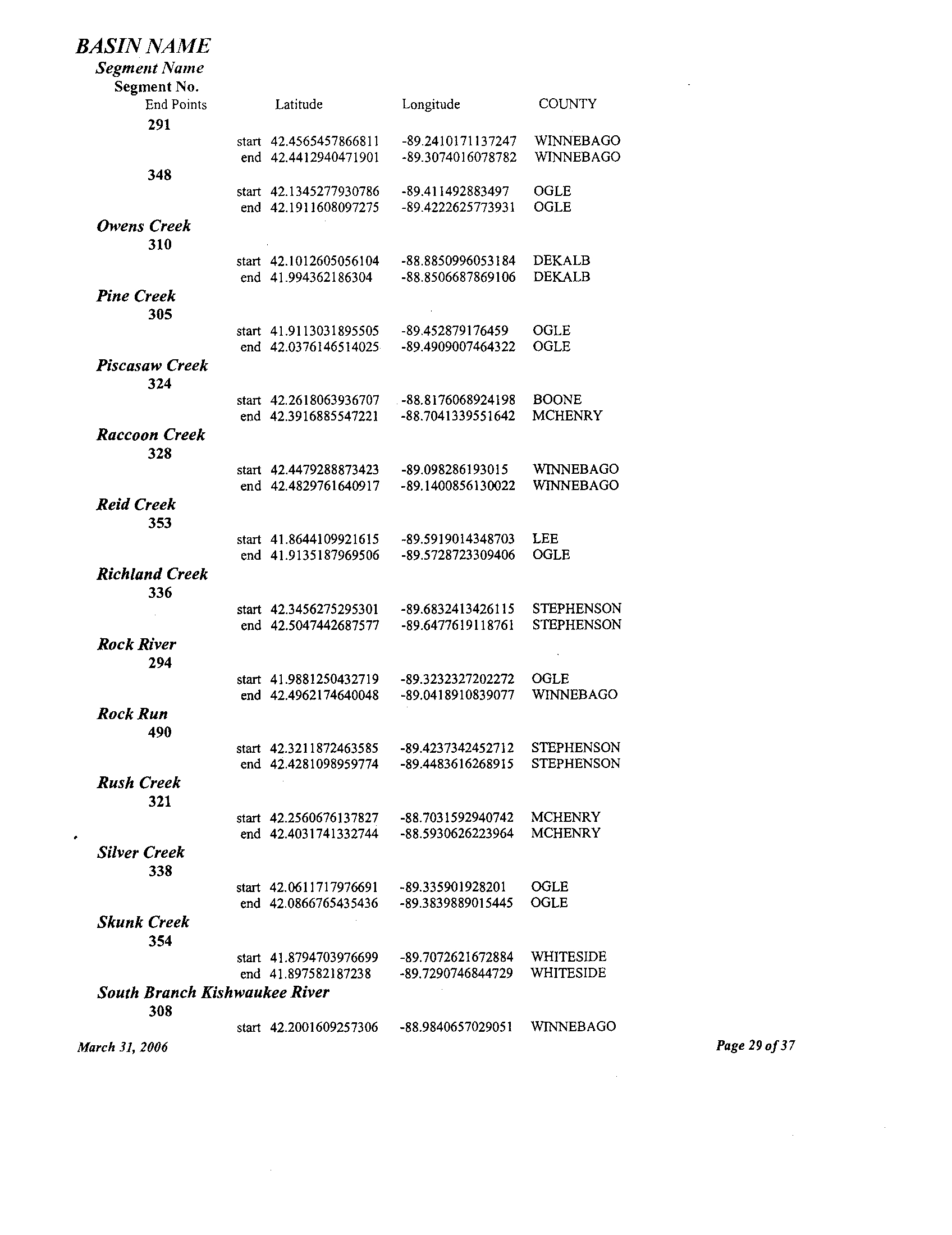
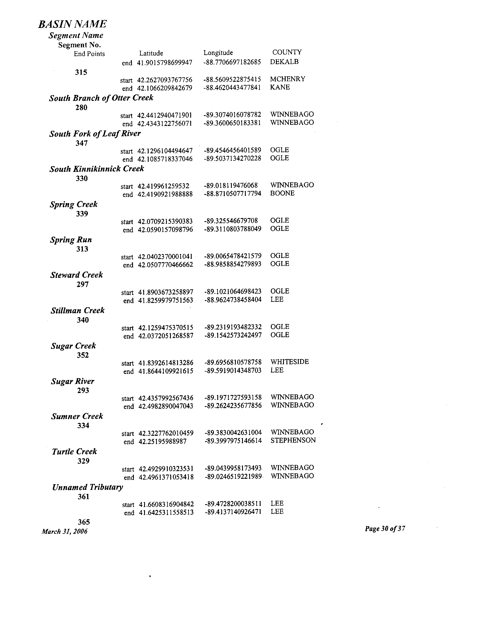
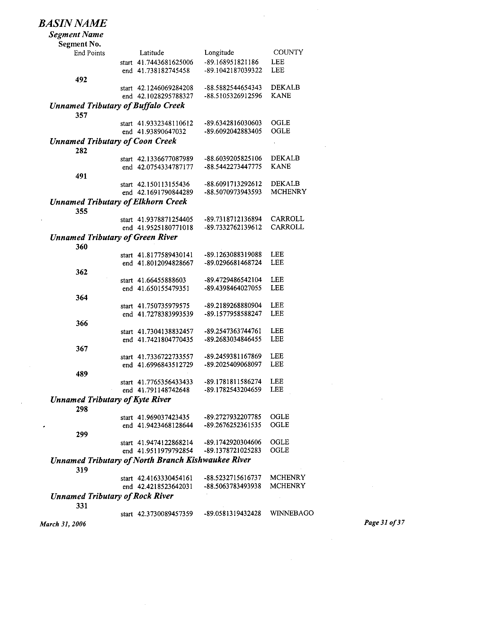
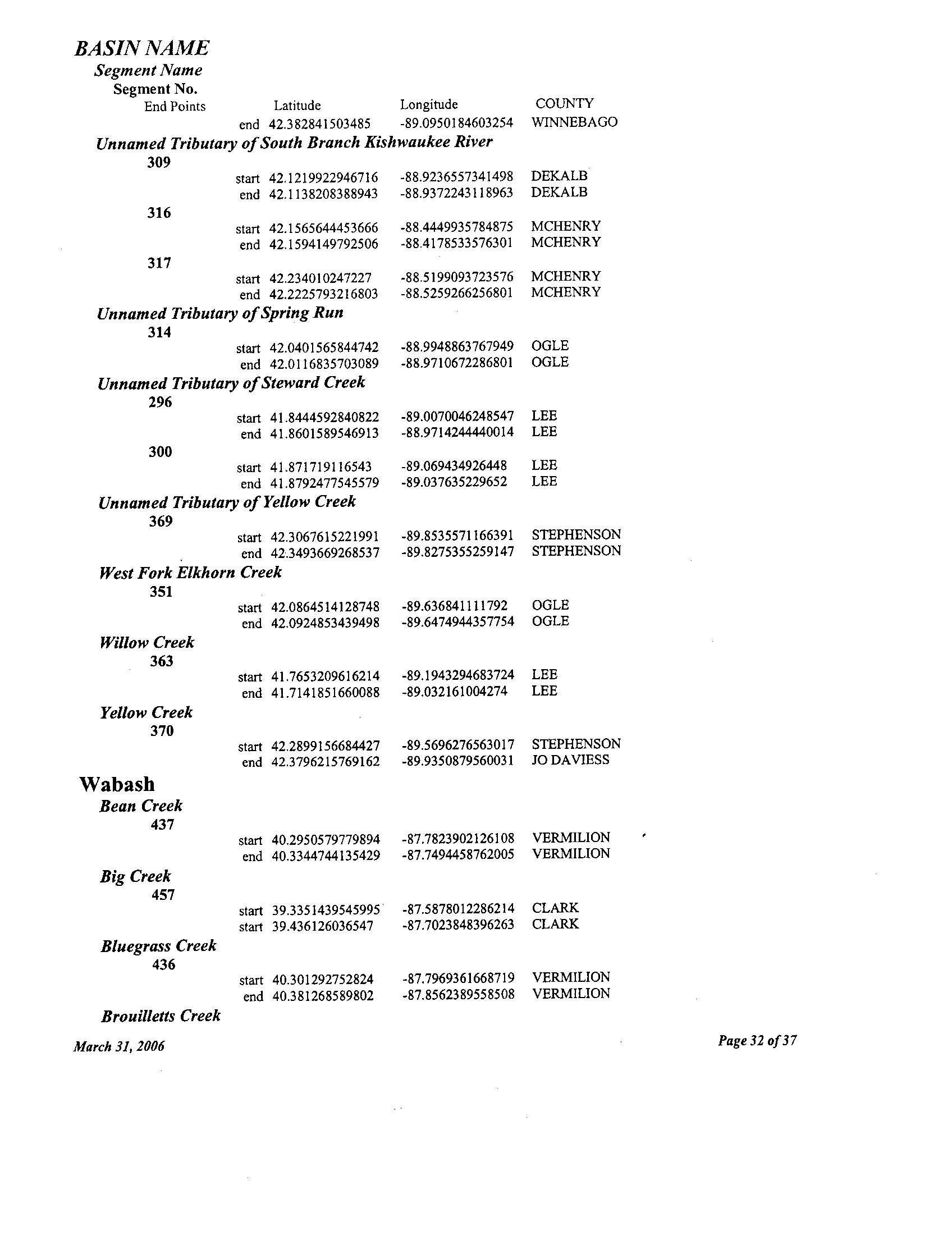
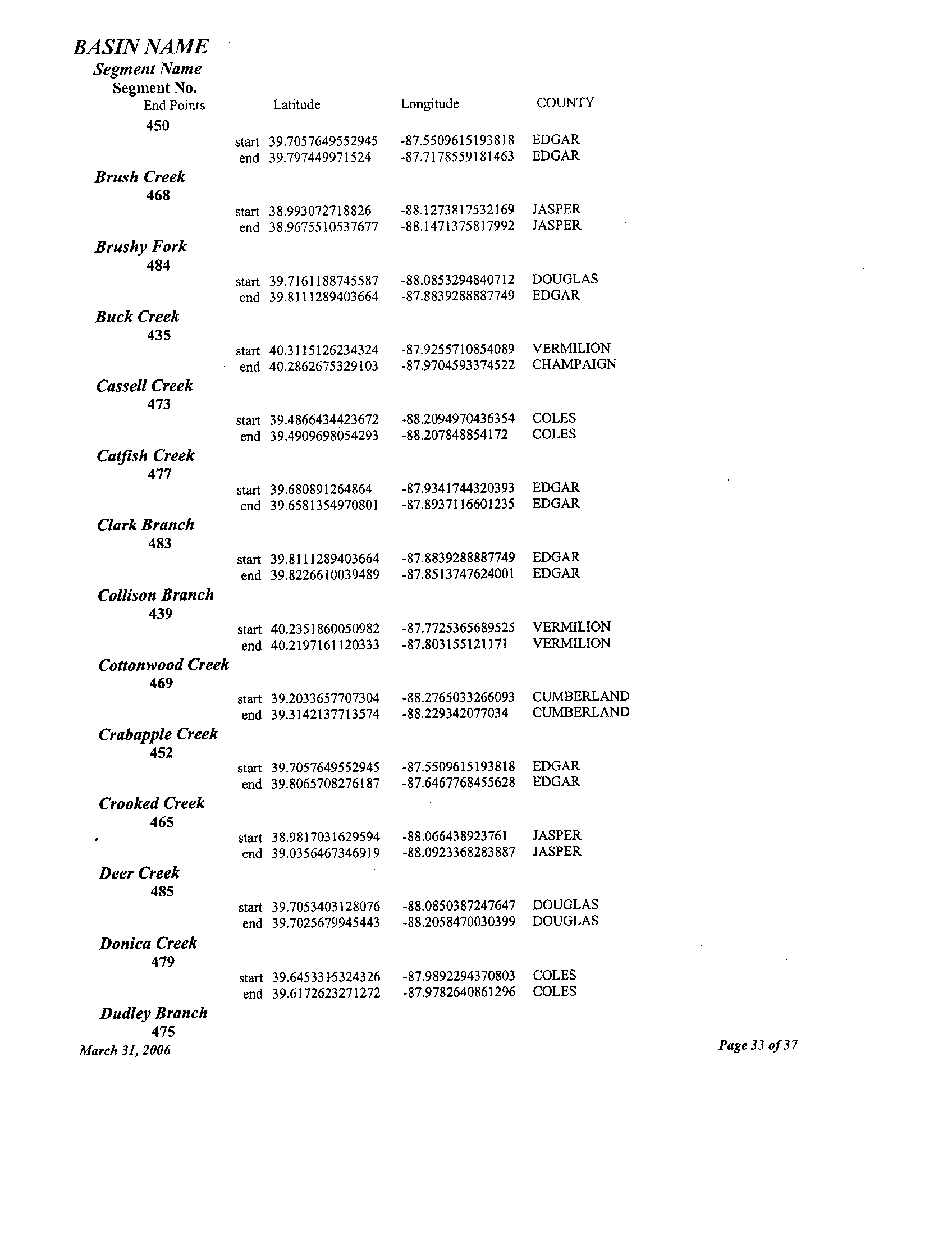
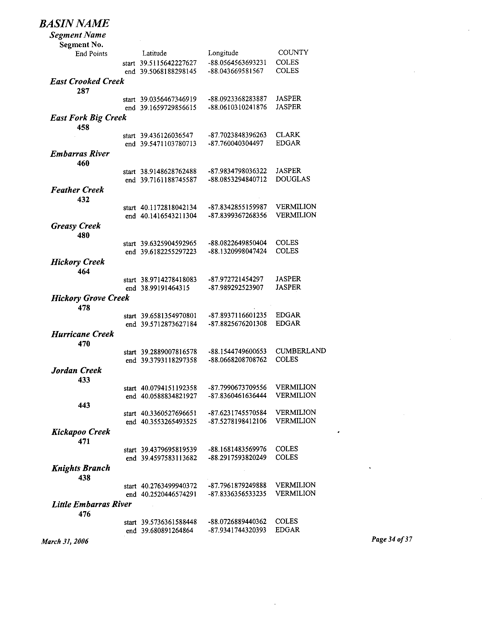
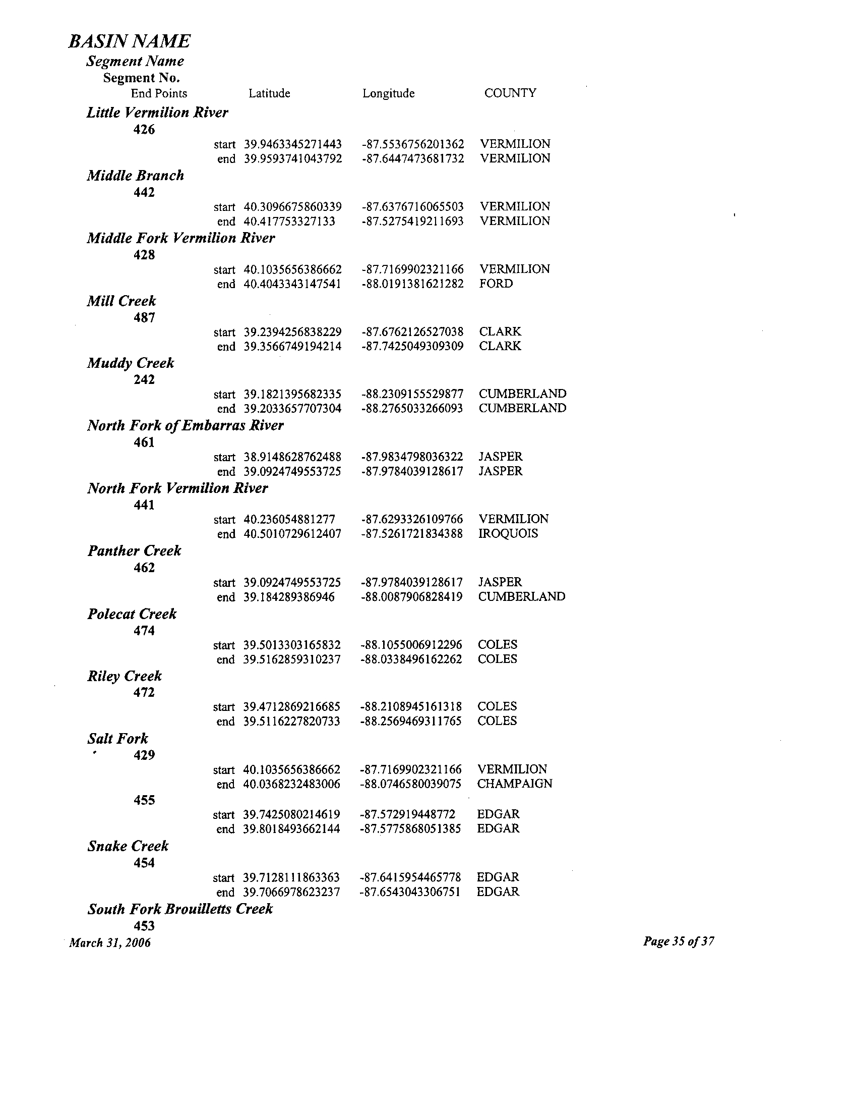
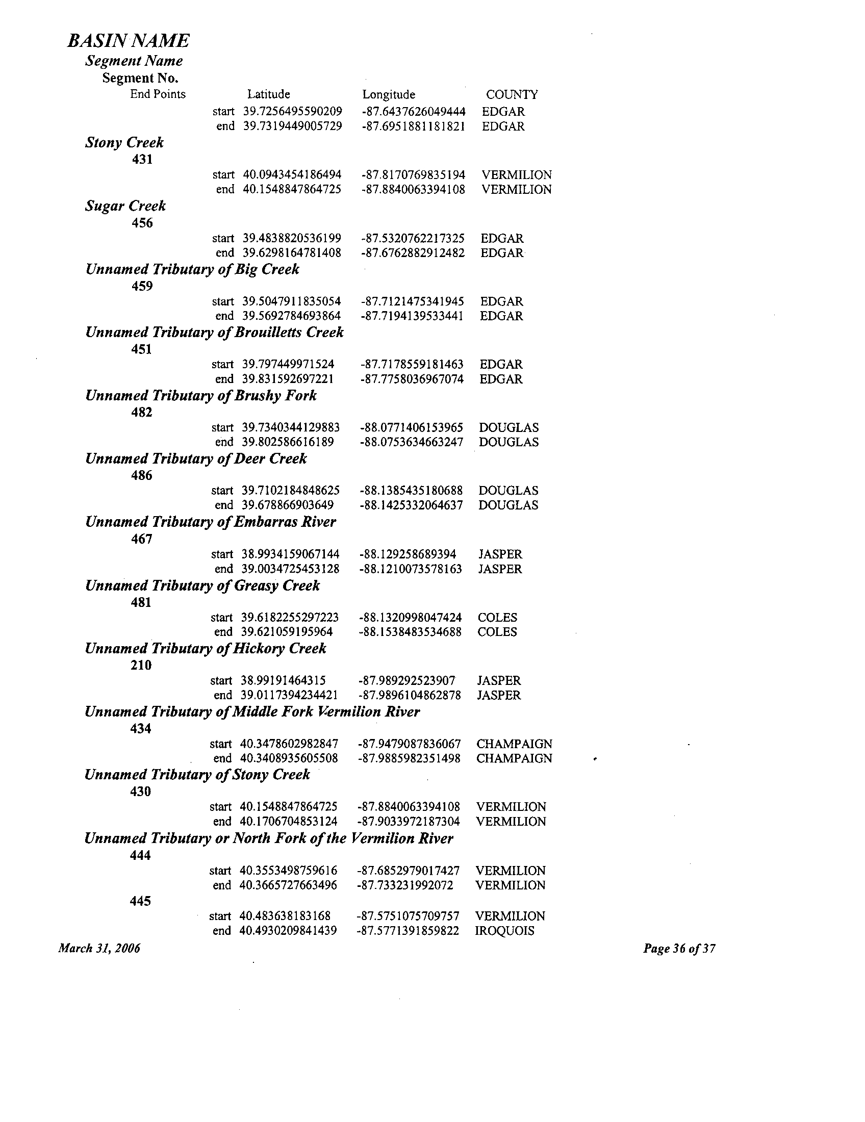
BASIN NAME
Segment Name
Segment No .
End Points
Latitude
Longitude
COUNTY
Illinois
Aux Sable Creek
239
start 41 .3982125891033 -88.3307365155966 GRUNDY
end 41 .5221610266554
-88 .3153074461322 KENDALL
Baker Creek
123
start 41 .0993159446094 -87.833779044559
KANKAKEE
end 41 .1187483257075 -87.7916507082604 KANKAKEE
Baptist Creek
160
start 40.5172643895406 -90.9781701980636 HANCOCK
end 40.5217773790395 -90.9703232423026 HANCOCK
Barker Creek
170
start 40.4730175690641 90 .3623822544051 FULTON
end 40.4505102531327 -90.423698306895 FULTON
Battle Creek
196
start 41 .791467372356 -88.6440656199133
DEKALB
end 41 .8454435074814 -88.6580317835588 DEKALB
Big Bureau Creek
209
start 41 .2403303426443 -89.3778305139628
BUREAU
end 41 .6599418992971 -89.0880711727354 LEE
Big Rock Creek
275
start 41 .6325949399571 -88.5379727020413 KENDALL
end 41
.7542831812644 -88 .5621629654129 KANE
Blackberry Creek
271
start 41 .6432480686252 -88 .451129393594 KENDALL
end 41 .7663693677829 -88 .3855968808499 KANE
Boone Creek
284
start 42 .3430701828297 -88 .2604646456881 MCHENRY
end 42 .3116813126792
-88 .3284649937798 MCHENRY
Buck Creek
225
start 41 .4305449377211 -88 .7732713228626
LASALLE
end 41 .4508806057478
-88 .919966063547 LASALLE
403
start 40 .6513984442885 -88
.8660496976016 MCLEAN
end 40 .6757825960266 -88 .8490439132056
MCLEAN
Camp Creek
116
start 41 .0119168530464 -89.7317034650143 STARK
end 41 .0202988179758 -89.6817209218761
STARK
March 31, 2006
Page 1 of 37
BASIN NAME
Court Creek
122
March 31, 2006
Page 2 of 37
Segment Name
Segment No .
End Points
168
Latitude
Longitude
COUNTY
start 40
.2936155016035 -90 .7791785207262
MCDONOUGH
end 40 .3985161419285 -90
.5089903510732 MCDONOUGH
Camp Run
115
start 41
.0119168530464 -89 .7317034650143
STARK
end 41 .0575944852479
-89 .6822685234528 STARK
Cantway Slough
250
start 41
.1654521279715 -87 .6179423055771
KANKAKEE
end 41
.1204910206261 -87 .6018847740212 KANKAKEE
Cedar Creek
164
start 40
.4187924503946 -91 .0119249544251 HANCOCK
end 40 .4320989747514
-90 .9816512014458 HANCOCK
Central Ditch
17
start 40
.2466345144431 -89 .8605138200519
MASON
end 40
.259146892407 -89 .8331744969958 MASON
Clear Creek
. 70
start 40 .2358631766436
-89 .1715114085864 LOGAN
end 40.2817523596784 -89
.2105606026356 MCLEAN
Coal Creek
173
start 40 .6458316286298
-90 .2773695191768 FULTON
end 40 .6911917975894 -90
.0990104026141- FULTON
Collins Run
243
start 41
.4219631544372 -88 .3508108111242 GRUNDY
end 41 .4172036201222
-88 .3955434158999 GRUNDY
Conover Branch
184
start 39 .8376993452498 -90 .1465720267561
MORGAN
end 39
.8696939232648 -90 .1234898871846
MORGAN
Coon Creek
60
start 40 .1076562155273
-89 .0130117597621 DEWITT
end 40 .1755351290733
-88 .8857086715202 DEWITT
Coop Branch
31
end 39 .2042878811665 -90
.0972130791043 MACOUPIN
end 39 .1194481626997 -89 .9878509202749
MACOUPIN
Coopers Defeat Creek
114
start 41 .1557502062867 -89
.748162019475 STARK
end 41 .1485959333575 -89 .6944246708098
STARK
Copperas Creek
88
start 40 .4856512052475
-89 .8867983078194 FULTON
end 40 .549513691198 -89
.9011907117391 FULTON
BASIN NAME
March 31, 2006
Page 3 of 37
Segment Name
Segment No .
End Points
Latitude
start 40 .9184191403691
Longitude
-90 .1108008628507
COUNTY
KNOX
end 40 .9349919352638
-90 .2673514797552 KNOX
Cox Creek
177
start 40 .0231674243157 -90 .1158780774246
CASS
end 39
.9657957063914 -90 .0180644049351 CASS
Crane Creek
174
start 40 .1328714038267 -89 .9709414534257
MENARD
end 40 .2466345144431 -89 .8605138200519
MASON
Crow Creek
102
start 40.9323207251964
-89 .4264477600798 MARSHALL
end 40.9663161180876 -89
.2558617294218 MARSHALL
Deer Creek
59
start 40 .117679723776 -89
.3801215076251 LOGAN
end 40 .1915602627115
-89 .1582023776838 LOGAN
Des Plaines River
245
start 41
.3923135096469 -88 .2590124225285 GRUNDY
end 41 .4325013563553 -88
.1725611633353 WILL
Dickerson Slough
421
start 40 .3597968706068 -88 .3225685158141 CHAMPAIGN
end 40 .4568389800294 -88
.3442742579475 FORD
Drummer Creek
423
start 40 .37389931547
-88 .3480753423386
CHAMPAIGN
end 40 .479101489993
-88 .388698487066 FORD
Dry Fork
35
start 39 .1989703827155 -89
.9609795725648 MACOUPIN
end 39
.1445756951412 -89 .8876581181152
MACOUPIN
Du Page River
268
start 41 .4988385272507
-88 .2166248594859 WILL
end 41
.7019525201778 -88 .1476209409341 WILL
Eagle Creek
392
start 41 .1360015419764
-88 .8528525904771 LASALLE
end 41 .1291172842462 -88
.8664977236647 LASALLE
East Aux Sable Creek
240
start 41 .5221610266554
-88 .3153074461322 KENDALL
end 41 .6231669397764 -88
.2938779285952 KENDALL
East Branch Big Rock Creek
277
start 41
.7542830239271 -88 .5621632556731
KANE
end 41
.8161922949561 -88 .6002917634599 KANE
East Branch Copperas Creek
47
start 40 .549514632509 -89 .901189903351
FULTON
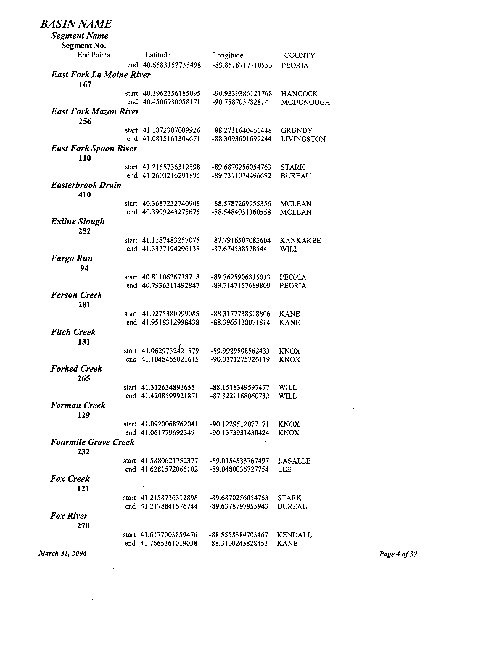
BASIN NAME
Segment Name
Segment No
.
End Points
Latitude
end 40 .6583152735498
Longitude
-89
.8516717710553
COUNTY
PEORIA
East Fork La Moine River
167
start 40
.3962156185095 -90 .9339386121768 HANCOCK
end 40 .4506930058171 -90 .758703782814
MCDONOUGH
East Fork Mazon River
256
start 41 .1872307009926 -88 .2731640461448
GRUNDY
end 41 .0815161304671
-88 .3093601699244 LIVINGSTON
East Fork Spoon River
110
start 41 .2158736312898 -89 .6870256054763 STARK
end 41 .2603216291895 -89 .7311074496692
BUREAU
Easterbrook Drain
410
start 40.3687232740908 -88
.5787269955356 MCLEAN
end 40
.3909243275675 -88 .5484031360558 MCLEAN
Exline Slough
252
start 41 .1187483257075 -87 .7916507082604 KANKAKEE
end 41 .3377194296138 -87 .674538578544
WILL
Fargo Run
94
start 40 .8110626738718 -89 .7625906815013 PEORIA
end 40 .7936211492847 -89 .7147157689809 PEORIA
Ferson Creek
281
start 41 .9275380999085 -88
.3177738518806 KANE
end 41 .9518312998438 -88 .3965138071814 KANE
Fitch Creek
131
start 41
.0629732121579 -89.9929808862433 KNOX
end 41 .1048465021615 -90.0171275726119 KNOX
Forked Creek
265
start 41 .312634893655 -88 .1518349597477 WILL
end 41 .4208599921871 -87 .8221168060732 WILL
Forman Creek
129
start 41 .0920068762041
-90
.1229512077171 KNOX
end 41 .061779692349 -90 .1373931430424 KNOX
Fourmile Grove Creek
232
start 41 .5880621752377 -89 .0154533767497 LASALLE
end 41 .6281572065102 -89 .0480036727754 LEE
Fox Creek
121
start 41 .2158736312898 -89 .6870256054763 STARK
end 41 .2178841576744 -89 .6378797955943 BUREAU
Fox River
270
start 41 .6177003859476 -88 .5558384703467 KENDALL
end 41 .7665361019038 -88 .3100243828453 KANE
March 31, 2006
Page 4 of37
BASIN NAME
Hickory Run
93
March 31, 2006
Page 5
of
37
Segment Name
Segment No .
End Points
Latitude
Longitude
COUNTY
Friends Creek
56
start 39 .9296881580789 -88 .7753341828841 MACON
end 40 .0511150621524
-88 .756810733868 MACON
Furrer Ditch
175
start 40 .259146892407 -89
.8331744807195 MASON
end 40 .256856262248
-89.8235353908665 MASON
Gooseberry Creek
138
start 41 .0815161304671
-88 .3093601699244 LIVINGSTON
end 41 .0229178273291 -88
.3433997610298 LIVINGSTON
181
start 41 .2273512263311
-88 .3737634512576 GRUNDY
end 41 .1567969821084 -88
.3954921510714 GRUNDY
Grindstone Creek
169
start 40 .2936155016035 -90.7791785207262 MCDONOUGH
end 40 .3128991202966
-90.6514786739624 MCDONOUGH
Hall Ditch
176
start 40 .214043063866 -89
.8947856138658 MASON
end 40 .1996396083582 -89 .8430392085184
MASON
Hallock Creek
101
start 40 .9330251540704
-89.523027406387 PEORIA
end 40 .9162496002415 -89
.5368879858621 PEORIA
Haw Creek
125
start 40
.8575772861862 -90.2335091570553 KNOX
end 40 .9174343445877 -90.3387634753254
KNOX
Henline Creek
401
start 40 .5867014223785 -88 .6971328093932
MCLEAN
end 40 .6247936449316 -88 .6315733675586
MCLEAN
Henry Creek
100
start 40 .932455717876
-89 .5256512687818 PEORIA
end 40 .9472322228041
-89 .5711427004422 PEORIA
Hermon Creek
126
start 40 .7818347201379 -90 .2738699961108
KNOX
end 40 .7628476930817 -90 .3372052339614
KNOX
Hickory Creek
244
start 41 .5038289458964 -88
.0990240076033 WILL
end 41 .4935392717868 -87 .8108342251738
WILL
Hickory Grove Ditch
87
start 40 .4870721779667 -89
.7285827911466 TAZEWELL
end 40 .4136575635669 -89 .7349507058786
MASON
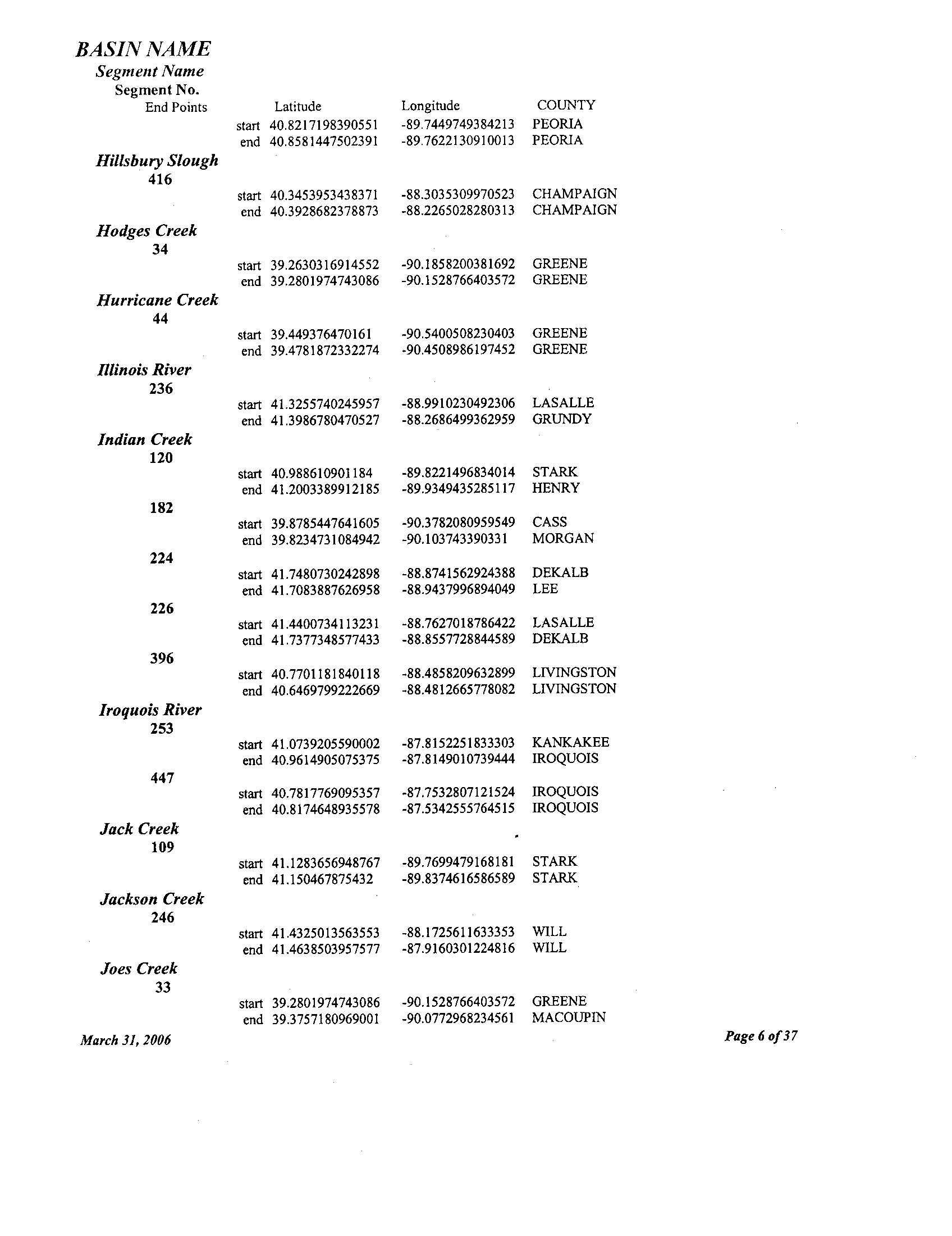
BASIN NAME
Segment Name
Segment No .
End Points
Latitude
start 40
.8217198390551
Longitude
-89 .7449749384213
COUNTY
PEORIA
end 40 .8581447502391
-89 .7622130910013 PEORIA
Hillsbury Slough
416
start 40.3453953438371
-88 .3035309970523
CHAMPAIGN
end 40.3928682378873
-88 .2265028280313 CHAMPAIGN
Hodges Creek
34
start 39 .2630316914552 -90
.1858200381692 GREENE
end 39 .2801974743086 -90 .1528766403572
GREENE
Hurricane Creek
44
start 39
.449376470161 -90 .5400508230403
GREENE
end 39 .4781872332274
-90 .4508986197452 GREENE
Illinois River
236
start 41
.3255740245957 -88
.9910230492306 LASALLE
end 41 .3986780470527
-88 .2686499362959 GRUNDY
Indian Creek
120
start 40
.988610901184 -89 .8221496834014
STARK
end 41 .2003389912185 -89
.9349435285117 HENRY
182
start 39
.8785447641605 -90.3782080959549 CASS
end 39 .8234731084942 -90.103743390331
MORGAN
224
start 41 .7480730242898 -88 .8741562924388
DEKALB
end 41
.7083887626958 -88 .9437996894049
LEE
226
start 41 .4400734113231 -88 .7627018786422
LASALLE
end 41 .7377348577433 -88 .8557728844589
DEKALB
396
start 40 .7701181840118 -88 .4858209632899
LIVINGSTON
end 40 .6469799222669
-88 .4812665778082
LIVINGSTON
Iroquois River
253
start 41 .0739205590002 -87
.8152251833303 KANKAKEE
end 40.9614905075375 -87
.8149010739444 IROQUOIS
447
start 40.7817769095357
-87 .7532807121524
IROQUOIS
end 40.8174648935578
-87 .5342555764515 IROQUOIS
Jack Creek
109
start 41
.1283656948767 -89 .7699479168181
STARK
end 41 .150467875432
-89 .8374616586589 STARK
Jackson Creek
246
start 41 .4325013563553 -88 .1725611633353
WILL
end 41
.4638503957577 -87 .9160301224816
WILL
Joes Creek
33
start 39 .2801974743086
-90 .1528766403572 GREENE
end 39 .3757180969001 -90.0772968234561
MACOUPIN
March 31, 2006
Page 6 of37
BASIN NAME
Segment Name
Segment No .
End Points
Johnny Run
258
Latitude
Longitude
COUNTY
start 41 .2826709079541 -88 .3633805819326
GRUNDY
end 41
.0807507198308 -88 .5801638050665 LIVINGSTON
Jordan Creek
266
start 41 .3044458242397
-88 .1279087273328 WILL
end 41 .3077177643453 -88 .1188984685001
WILL
Judd Creek
106
start 41
.089645284216 -89 .1847595119809
MARSHALL
end 41 .0429807674449 -89.1339049242164
MARSHALL
Kankakee River
248
start 41 .3923135096469 -88 .2590124225285
GRUNDY
end 41 .1660752568715
-87 .526360971907
KANKAKEE
Kickapoo Creek
57
start 39.9932216924528
-88 .8083252484687 MACON
end 39.9987405799186
-88 .8205170598483 MACON
65
start 40.1286520491088
-89 .4532728967436 LOGAN
end 40 .4376592310728 -88
.8667409562596 MCLEAN
92
start 40 .6548826785105
-89 .6134608723157 TAZEWELL
end 40 .9170471944911 -89 .6577393908301
PEORIA
Kings Mill Creek
83
start 40
.4558745105979 -89 .1642930044364
MCLEAN
end 40 .509184986927 -89
.0937965002854 MCLEAN
La Harpe Creek
159
start 40
.4678428297867 -91 .0424167497572
HANCOCK
end 40 .5172643895406 -90.9781701980636
HANCOCK
La Moine River
158
start 40 .3320849972693
-90.8997234923388 MCDONOUGH
end 40 .5923258750258
-91 .0177293656635 HANCOCK
Lake Fork
61
start 40 .0837107988142 -89.3969397975165
LOGAN
end 39
.9367293000733 -89 .2343282851812
LOGAN
Langan Creek
254
start 40 .9614905075375 -87.8149010739444
IROQUOIS
end 40 .9432018898477 -88 .0465558527168
IROQUOIS
Lime Creek
214
start 41 .4515003790233
-89 .5271752648714 BUREAU
end 41 .4951141474998 -89
.456554884734 BUREAU
Little Indian Creek
183
start 39 .8355964564522
-90 .1231971747256 MORGAN
March 31, 2006
Page 7 of 37
BASIN NAME
Madden Creek
413
March 31, 2006
Page 8 of 37
Segment Name
Segment No .
End Points
Latitude
Longitude
COUNTY
end 39 .8658175367056 -90 .0423591294145
MORGAN
227
start 41 .5091299863247 -88 .7725444056074
LASALLE
end 41 .749433980972 -88 .8141442269697
DEKALB
Little Kickapoo Creek
67
start 40 .3336625070255 -88 .9736094275975
MCLEAN
end 40 .394785197415 -88 .9473142490326
MCLEAN
Little Mackinaw River
82
start 40 .4423190352496
-89 .4617848276975
TAZEWELL
end 40 .4481261917524
-89 .4329939054056 TAZEWELL
Little Rock Creek
274
start 41 .6345548769785 -88
.5384723455853 KENDALL
end 41
.7895688619816 -88 .6981590581244
DEKALB
Little Sandy Creek
107
start 41 .0912632622075
-89 .2247552498617 MARSHALL
end 41 .125352501365 -89 .1758716886846
PUTNAM
Little Senachwine Creek
99
start 40.9533145540839 -89
.5292433956921 PEORIA
end 41
.0084439145565 -89 .5499765139822
MARSHALL
Little Vermilion River
233
start 41 .3237602050852 -89
.0811945323001 LASALLE
end 41 .5760289435671
-89 .0829047126545
LASALLE
Lone Tree Creek
418
start 40 .3750682121535 -88
.3819688457729 CHAMPAIGN
end 40
.3145980401842 -88 .4738655755984
MCLEAN
Long Creek
163
start 40
.4466427913955 -91 .0499607552846
HANCOCK
end 40 .4297652043359
-91 .1507109600489 HANCOCK
Long Point Creek
68
start 40 .2755311999445
-89 .0786438507327 DEWITT
end 40 .2549604211821 -88
.9826285651361 DEWITT
394
start 41 .038177645276 -88
.7908409579793 •LIVINGSTON
end 41 .0018214714974 -88
.8534349418926 LIVINGSTON
Mackinaw River
397
start 40.5796794158534
-89 .2813445945626
TAZEWELL
end 40 .5649627479232
-88 .478822725546 MCLEAN
Macoupin Creek
32
start 39
.1989703827155 -89 .9609795725648
MACOUPIN
start 39 .2121253451487
-90 .2312084410337 JERSEY
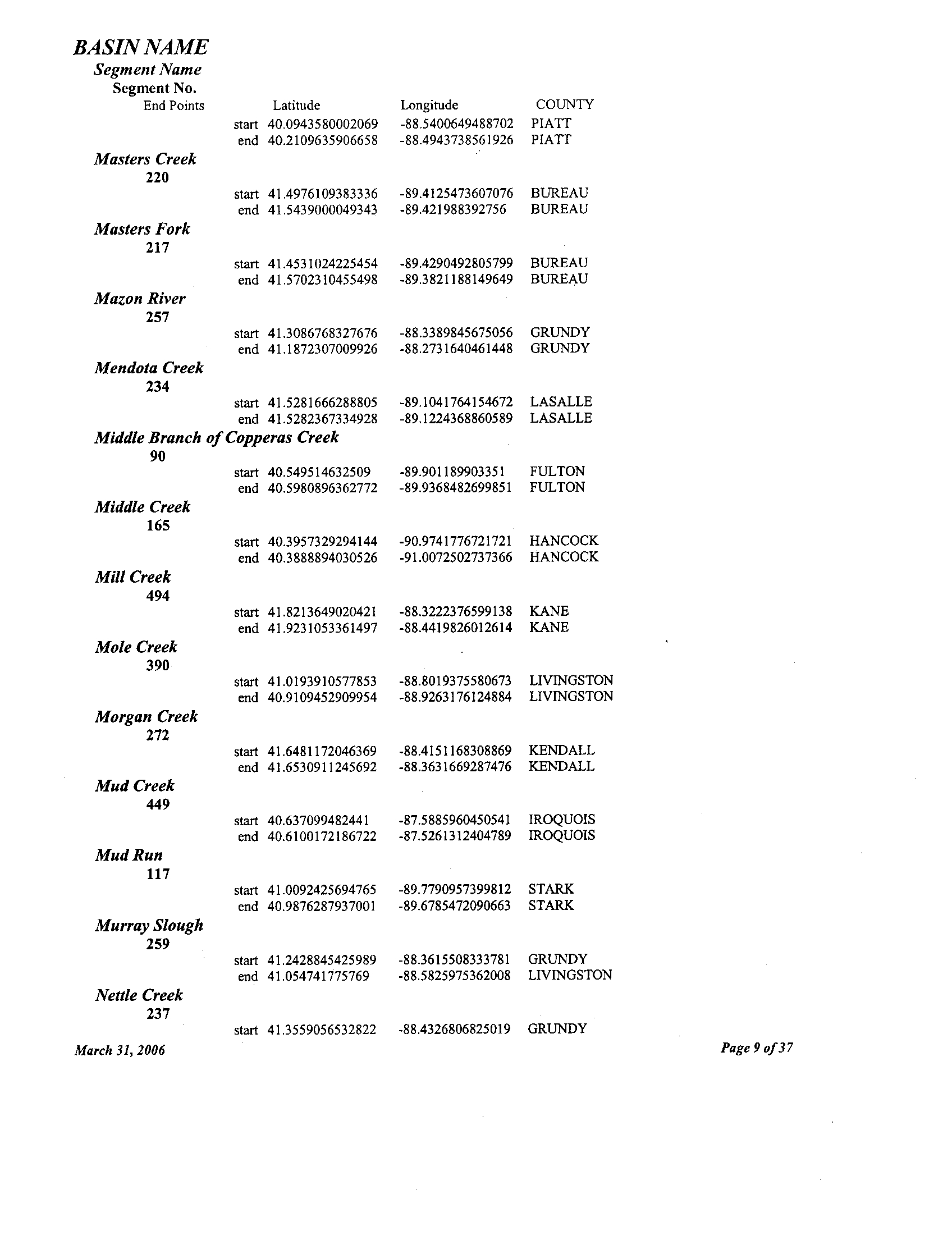
BASIN NAME
Segment Name
Segment No .
End Points
Latitude
start 40 .0943580002069
Longitude
-88 .5400649488702
COUNTY
PLATT
end 40.2109635906658 -88.4943738561926 MATT
Masters Creek
220
start 41 .4976109383336
-89.4125473607076 BUREAU
end 41 .5439000049343 -89.421988392756
BUREAU
Masters Fork
217
start 41 .4531024225454 -89.4290492805799 BUREAU
end 41 .5702310455498 -89.3821188149649
BUREAU
Mazon River
257
start 41 .3086768327676
-88 .3389845675056 GRUNDY
end 41 .1872307009926 -88 .2731640461448 GRUNDY
Mendota Creek
234
start 41 .5281666288805 -89.1041764154672 LASALLE
end 41 .5282367334928 -89.1224368860589
LASALLE
Middle Branch of Copperas Creek
90
start 40.549514632509 -89.901189903351
FULTON
end 40.5980896362772 -89 .9368482699851
FULTON
Middle Creek
165
start 40.3957329294144
-90.9741776721721 HANCOCK
end 40.3888894030526 -91
.0072502737366 HANCOCK
Mill Creek
494
start 41 .8213649020421
-88 .3222376599138 KANE
end 41 .9231053361497 -88 .4419826012614
KANE
Mole Creek
390
start 41 .0193910577853 -88 .8019375580673
LIVINGSTON
end 40 .9109452909954 -88 .9263176124884 LIVINGSTON
Morgan Creek
272
start 41 .6481172046369 -88 .4151168308869
KENDALL
end 41 .6530911245692 -88.3631669287476
KENDALL
Mud Creek
449
start 40 .637099482441 -87.5885960450541 IROQUOIS
end 40
.6100172186722 -87.5261312404789 IROQUOIS
Mud Run
117
start 41 .0092425694765 -89.7790957399812
STARK
end 40 .9876287937001 -89.6785472090663 STARK
Murray Slough
259
start 41 .2428845425989 -88.3615508333781
GRUNDY
end 41 .054741775769 -88.5825975362008
LIVINGSTON
Nettle Creek
237
start 41 .3559056532822
-88 .4326806825019 GRUNDY
March 31, 2006
Page 9 of37
BASIN NAME
Segment Name
Segment No .
End Points
Latitude
end 41 .3989525138118
Longitude
-88 .5519708865374
COUNTY
GRUNDY
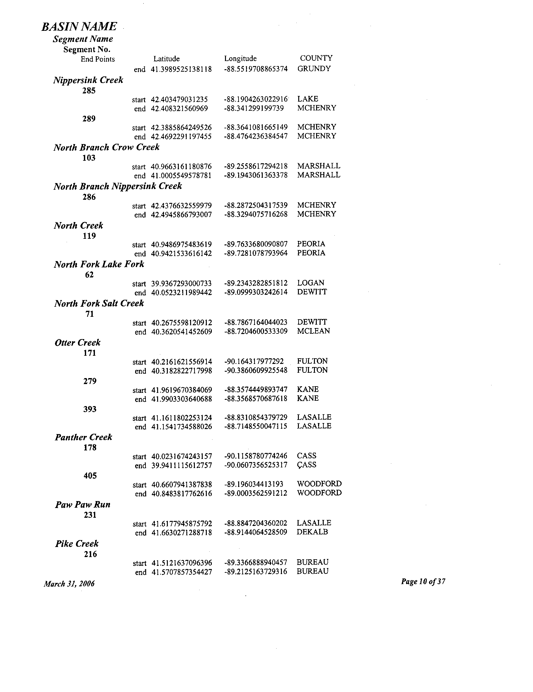
Nippersink Creek
285
start 42 .403479031235 -88 .1904263022916
LAKE
end 42
.408321560969 -88 .341299199739
MCHENRY
289
start 42 .3885864249526 -88 .3641081665149
MCHENRY
end 42
.4692291197455 -88 .4764236384547 MCHENRY
North Branch Crow Creek
103
start 40 .9663161180876
-89 .2558617294218 MARSHALL
end 41 .0005549578781 -89 .1943061363378
MARSHALL
North Branch Nippersink Creek
286
start 42
.4376632559979 -88 .2872504317539 MCHENRY
end 42 .4945866793007
-88 .3294075716268 MCHENRY
North Creek
119
start 40.9486975483619 -89 .7633680090807
PEORIA
end 40.9421533616142 -89 .7281078793964
PEORIA
North Fork Lake Fork
62
start 39.9367293000733
-89 .2343282851812 LOGAN
end 40 .0523211989442 -89
.0999303242614 DEWITT
North Fork Salt Creek
71
start 40 .2675598120912
-88 .7867164044023 DEWITT
end 40 .3620541452609
-88 .7204600533309 MCLEAN
Otter Creek
171
start 40 .2161621556914 -90 .164317977292
FULTON
end 40
.3182822717998 -90 .3860609925548 FULTON
279
start 41
.9619670384069 -88 .3574449893747 KANE
end 41 .9903303640688
-88 .3568570687618 KANE
393
start 41
.1611802253124 -88 .8310854379729 LASALLE
end 41
.1541734588026 -88 .7148550047115
LASALLE
Panther Creek
178
start 40
.0231674243157 -90 .1158780774246 CASS
end 39 .9411115612757
-90 .0607356525317 ASS
405
start 40 .6607941387838
-89 .196034413193 WOODFORD
end 40 .8483817762616 -89
.0003562591212 WOODFORD
Paw Paw Run
231
start 41
.6177945875792 -88 .8847204360202 LASALLE
end 41 .6630271288718
-88 .9144064528509 DEKALB
Pike Creek
216
start 41
.5121637096396 -89 .3366888940457 BUREAU
end 41 .5707857354427
-89 .2125163729316 BUREAU
March
31, 2006
Page 10 of 37
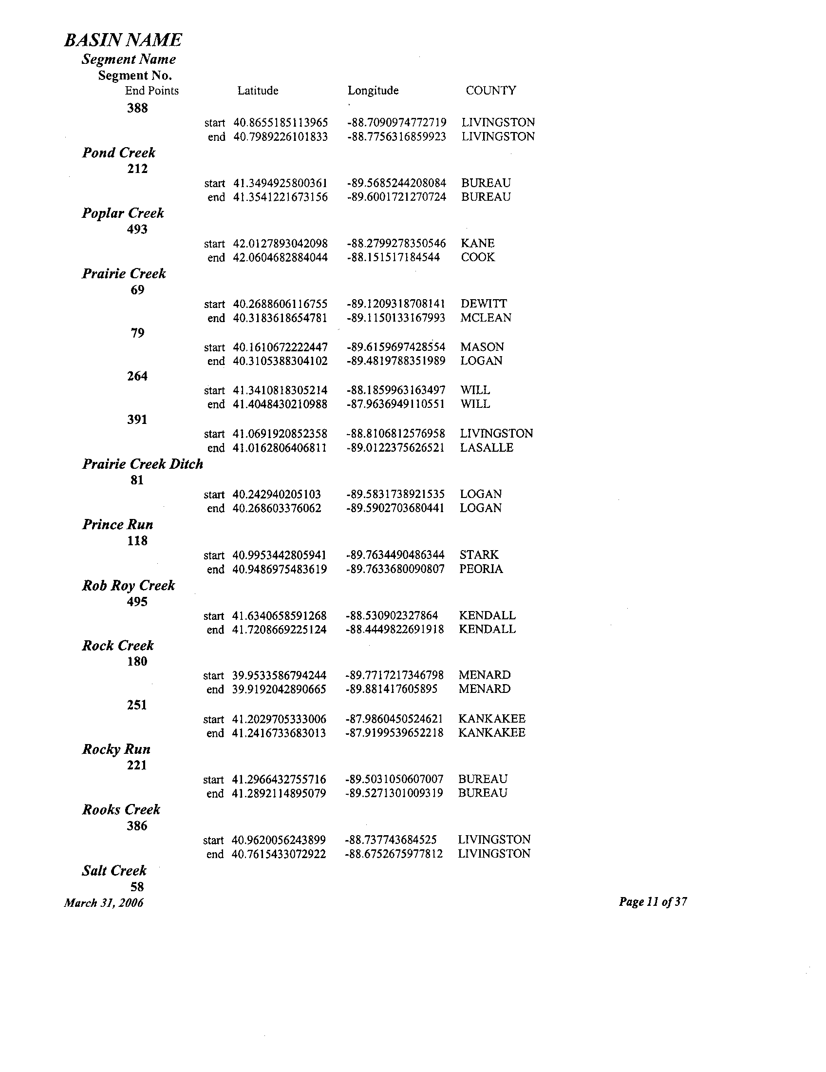
BASIN NAME
Segment Name
Segment No.
End Points
Latitude
Longitude
COUNTY
388
start 40 .8655185113965 -88 .7090974772719 LIVINGSTON
end 40 .7989226101833 -88 .7756316859923 LIVINGSTON
Pond Creek
212
start 41 .3494925800361 -89 .5685244208084 BUREAU
end 41 .3541221673156 -89
.6001721270724 BUREAU
Poplar Creek
493
start 42 .0127893042098 -88.2799278350546 KANE
end 42 .0604682884044 -88 .151517184544 COOK
Prairie Creek
69
start 40 .2688606116755 -89.1209318708141 DEWITT
end 40 .3183618654781 -89.1150133167993 MCLEAN
79
start 40 .1610672222447 -89.6159697428554
MASON
end 40.3105388304102 -89.4819788351989 LOGAN
264
start 41 .3410818305214 -88.1859963163497 WILL
end 41.4048430210988 -87.9636949110551
WILL
391
start 41.0691920852358
-88 .8106812576958 LIVINGSTON
end 41.0162806406811 -89.0122375626521 LASALLE
Prairie Creek Ditch
81
start 40.242940205103 -89 .5831738921535 LOGAN
end
40.268603376062
-89 .5902703680441 LOGAN
Prince Run
118
start 40.9953442805941 -89 .7634490486344 STARK
end 40.9486975483619 -89
.7633680090807 PEORIA
Rob Roy Creek
495
start 41 .6340658591268 -88.530902327864 KENDALL
end 41 .7208669225124 -88.4449822691918 KENDALL
Rock Creek
180
start 39.9533586794244 -89.7717217346798 MENARD
end 39.9192042890665 -89.881417605895 MENARD
251
start 41 .2029705333006
-87.9860450524621 KANKAKEE
end 41 .2416733683013 -87.9199539652218
KANKAKEE
Rocky Run
221
start 41 .2966432755716 -89.5031050607007 BUREAU
end 41 .2892114895079 -89 .5271301009319 BUREAU
Rooks Creek
386
start 40 .9620056243899 -88 .737743684525 LIVINGSTON
end 40 .7615433072922 -88 .6752675977812 LIVINGSTON
Salt Creek
58
March 3I, 2006
Page 11 of 37
BASIN NAME
Segment Name
Segment No .
End Points
Latitude
start 40 .1286520491088
Longitude
-89 .4532728967436
COUNTY
LOGAN
end 40 .1404369482862 -88 .8817439726269 DEWITT
409
start 40
.2793653821328 -88 .6019348286105 DEWITT
end 40 .3687232740908 -88 .5787269955356 MCLEAN
Sandy Creek
105
start 41 .1083947129797 -89 .3471796913242 PUTNAM
end 41 .0855613697751 -89 .0792291942694
MARSHALL
Sangamon River
408
start 40 .0056362283258 -88
.6286241506431 PIATT
end 40 .4223231153926 -88 .67328493366 MCLEAN
Senachwine Creek
96
start 40 .929825860388
-89 .4632928486271 PEORIA
end 41 .0900318754938 -89 .5885134178247
MARSHALL
Short Creek
162
start 40 .4611057719393 -91 .0582083107674 HANCOCK
end 40 .4682735975769 -91 .0704506789577 HANCOCK
Short Point Creek
389
start 40
.9883827214271 -88 .7830008925065 LIVINGSTON
end 40 .8951301673701 -88 .8749997260932
LIVINGSTON
Silver Creek
111
start 41 .2185762138697
-89 .6793069447094 STARK
end 41 .2431713087936 -89
.6494927441058 BUREAU
South Branch Crow Creek
104
start 40.9663161180876 -89 .2558617294218 MARSHALL
end 40.9410075148431 -89 .1948285503851 MARSHALL
South Branch Forked Creek
267
start 41 .2631372965881 -88 .0315238211836 WILL
end 41 .292604367733 -87 .9621751169561 KANKAKEE
South Fork Lake Fork
63
start 39 .9367293000733 -89 .2343282851812 LOGAN
end 39 .9674631778105 -89 .0884701339793 MACON
South Fork Vermilion River
395
start 40 .7701181840118 -88 .4858209632899 LIVINGSTON
end 40 .7234241258087 -88 .355790853647 LIVINGSTON
Spoon River
3
start 40 .883272448156 -90 .0994555125119 KNOX
end 41 .2158736312898 -89 .6870256054763 STARK
Spring Creek
161
start 40 .5838583294631
-91 .0397056763892 HANCOCK
end 40 .595079516268 -91 .0572149428165 HANCOCK
March 31, 2006
Page 12 of 37
BASIN NAME
Unnamed Tributary
230
March 31, 2006
Page 13 of 37
Segment Name
Segment No
.
End Points
Latitude
Longitude
COUNTY
166
start 40
.4506930058171 -90 .758703782814 MCDONOUGH
end 40 .5047702003096 -90 .7202911238868
MCDONOUGH
223
start 41 .3114342012759 -89
.1969933188526 BUREAU
end 41
.5341774964794 -89 .1599030581214 LASALLE
Stevens Creek
55
start 39
.833172054334 -89 .008501860042 MACON
end 39 .8725126750168 -88 .9902570309468
MACON
Sugar Creek
76
start 40 .1505909949415 -89 .6335239996087
MENARD
end 40 .3515916252906
-89 .1626966142058 MCLEAN
124
start 40
.9273148603695 -90 .1168866799652
KNOX
end 40 .9407150872189 -90
.126984172004 KNOX
448
start 40 .7817769095357
-87 .7532807121524
IROQUOIS
end 40 .650106664471
-87 .5259225515566 IROQUOIS
Sutphens Run
228
start 41 .5813276727649
-88 .9196815109252 LASALLE
end 41 .5940767755281 -89 .0434408697488
LASALLE
Swab Run
127
start 40.8043825531334
-90 .0417502151246 KNOX
end 40 .8089204046364 -89 .9959890937906
KNOX
Tenmile Creek
64
start 40 .1166122038468 -89 .0605809659338 DEWITT
end 40 .1573804135529 -88
.9870426654374 DEWITT
Timber Creek
77
start 40 .3499903738803 -89 .1633832938062
MCLEAN
end 40 .3824906556377
-89 .0653243216353 MCLEAN
Trim Creek
249
start 41 .1679695055755 -87 .6275919071884
KANKAKEE
end 41 .3235679470585 -87 .6273348723156 WILL
Turkey Creek
172
start 40 .5312633037562 -90
.2784734138591 FULTON
end 40 .6100168551688 -90 .1683886238592
FULTON
402
start 40 .6346912128201 -88 .8256051903746
MCLEAN
end 40
.6636296144043 -88 .7848217949076 MCLEAN
Tyler Creek
283
start 42 .057069434075 -88
.2869209701875 KANE
end 42 .0886074301339 -88 .3939734393445
KANE
BASIN NAME
Segment Name
Segment No .
End Points
Latitude
start 41 .6008353940091
Longitude
-88
.9239309686064
COUNTY
LASALLE
end 41
.6393800996109 -88 .95237726256 LEE
406
start 40 .8483817762616 -89 .0003562591212
WOODFORD
end 40
.8446321845668 -88 .9879480330159 WOODFORD
Unnamed Tributary of Big Bureau Creek
222
start 41 .2923889187328
-89 .4849627504116 BUREAU
end 41
.2746773653832 -89 .4967232161933 BUREAU
Unnamed Tributary of Coopers Defeat Creek
113
start 41
.1485959333575 -89 .6944246708098 STARK
end 41 .1432423938169 -89
.6549152326434 STARK
Unnamed Tributary of Dickerson Slough
422
start 40 .4068214049304 -88
.3388760698826 FORD
end 40.4286849455119
-88 .3118606581845
FORD
Unnamed Tributary of Drummer Creek
425
start 40.430183509928
-88 .3944923485681 FORD
end 40.4228198536222 -88
.4420280012069 FORD
Unnamed Tributary of East Branch of Copperas Creek
89
start 40.59257130763
-89 .8385498955685
PEORIA
start 40.59257130763
-89
.8385498955685 PEORIA
Unnamed Tributary of East Fork of Spoon River
112
start 41 .1911731339471 -89 .6948993736812
STARK
end 41
.1958777466981 -89 .6635132189552 STARK
Unnamed Tributary ofIndian Creek
185
start 39 .8195431621523 -90
.231206997871 MORGAN
end 39
.7997709298014 -90 .2444898890822
MORGAN
229
start 41 .5989641246871 -88
.913295513256 LASALLE
end 41
.6212302072922 -88
.9971274321449 LASALLE
Unnamed Tributary of Jackson Creek
247
start 41 .4328713295604 -88 .0777949404827
WILL
end 41 .4181859202087
-88 .0389954976751 WILL
Unnamed Tributary of Johnny Run
261
start 41 .1315090714299 -88
.5704499691513 GRUNDY
end 41 .1211734141418 -88 .5813177275807
GRUNDY
Unnamed Tributary ofKickapoo Creek
66
start 40 .4376592310728 -88
.8667409562596 MCLEAN
end 40 .4499435649154 -88 .7941853627565
MCLEAN
95
start 40 .843847234267 -89
.6598940056171 PEORIA
end 40 .8376970553513 -89 .655765678658
PEORIA
March 31, 2006
Page 14 of 37
BASIN NAME
March 31, 2006
Page 1 5 of37
Segment Name
Segment No .
End Points
Latitude
Longitude
COUNTY
Unnamed Tributary ofLone Tree Creek
417
start 40 .3145980401842 -88 .4738655755984
MCLEAN
end 40 .3084681821929 -88 .4721825603404 MCLEAN
419
start 40 .3200878690807 -88 .4758169784284
MCLEAN
end 40 .3246054213609 -88 .502979969789 MCLEAN
420
start 40 .3555955038811 -88 .4486860730234
CHAMPAIGN
end 40 .3553786361326
-88.4890287857383 MCLEAN
Unnamed Tributary ofMackinaw River
398
start 40 .5649627479232 -88
.478822725546 MCLEAN
end 40 .4956570103387 -88 .5106552787079
MCLEAN
399
start 40 .558742486097 -88
.5447290418444 MCLEAN
end 40 .532461937187 -88 .5550436512012
MCLEAN
400
start 40 .5536214693649
-88 .6155771894066 MCLEAN
end 40 .5386135050112 -88 .6150100834316
MCLEAN
Unnamed Tributary ofMasters Creek
219
start 41 .5407471962821 -89 .4154110620948 BUREAU
end 41 .5452528261938 -89 .4136798690744
BUREAU
Unnamed Tributary
ofMasters Fork
218
start 41 .510430587881
-89 .3900507138719
BUREAU
end
41
.6181398940954
-89 .2965280984998 LEE
Unnamed Tributary ofNettle Creek
238
start 41 .4088814108094 -88 .5216683950888
GRUNDY
end 41 .4186133676397
-88 .5339604493093 GRUNDY
Unnamed Tributary ofNippersink Creek
255
start 42 .4692291197455 -88
.4764236384547 MCHENRY
end 42 .4695432978934 -88 .5110499918451
MCHENRY
288
start 42.4176539163554 -88 .3444740410368 MCHENRY
end
42 .4179067763647 -88 .3502762821058 MCHENRY
290
start 42.3969278131381 -88 .4109784072142 MCHENRY
end 42.3875994074602 -88 .4491666706176
MCHENRY
Unnamed Tributary of North Fork of Salt Creek
72
start 40.3598944577027 -88 .7302360564635
MCLEAN
end 40.3811246400667
-88 .7481607936989
MCLEAN
73
start 40.3620541452609 -88 .7204600533309
MCLEAN
end 40.3690272117515
-88 .6961244618476 MCLEAN
75
start 40.2987649882463
-88 .7603546124853 MCLEAN
end 40.3051172967471 -88 .7525145171727
MCLEAN
Unnamed Tributary of Panther Creek
BASIN NAME
March 31, 2006
Page 1 6 of37
Segment Name
Segment No .
End Points
Latitude
Longitude
COUNTY
179
start 39
.9411115612757 -90 .0607356525317 CASS
end 39 .9350887523192
-90 .047762075576 CASS
Unnamed Tributary of Pond Creek
211
start
41 .3541221673156 -89 .6001721270724
BUREAU
end 41 .3352313411595
-89 .5875580793812 BUREAU
Unnamed Tributary of Prairie Creek
78
start 40 .2086608970772 -89 .6103029312127
MASON
end
40 .2239585519289 -89 .638616348402
MASON
80
start 40 .3105388304102 -89
.4819788351989 LOGAN
end 40
.3114851545122 -89.4410508250634
LOGAN
Unnamed Tributary of Rooks Creek
387
start 40 .7615433072922
-88 .6752675977812 LIVINGSTON
end 40 .7348742139519 -88.6985073106457
MCLEAN
Unnamed Tributary of Salt Creek
412
start 40 .3090617343957 -88 .6002511568763
MCLEAN
end
40 .3165662374132 -88 .6011454430269
MCLEAN
Unnamed Tributary of Sandy Creek
108
start 41 .0816545465891 -89 .0921996326175
MARSHALL
end 41 .0690044849354 -89 .0872784559417
MARSHALL
Unnamed Tributary of Sangamon River
414
start 40 .2187198550443
-88 .3726776422252 CHAMPAIGN
end 40 .207759150969 -88 .3556670563292
CHAMPAIGN
415
start 40 .2618571248343 -88
.3804307110291 CHAMPAIGN
end 40 .2604569179243 -88 .4076966986332
CHAMPAIGN
Unnamed Tributary of Senachwine Creek
97
start 41 .0729094906046
-89.5194162172506 MARSHALL
end 41 .1005615839111 -89.5247542292286
MARSHALL
98
start 41 .0008160428297 -89.5071527441621
MARSHALL
end 41 .0407981005047 -89 .5430844273656
MARSHALL
Unnamed Tributary of Walnut Creek
130
start 41 .0811500581416
-90.0632765005186 KNOX
end 41 .0847653353348 -90.0680765817376
KNOX
132
start 41 .0602585608831 -89.9869046205873
KNOX
end 41
.0721601609241 -89 .9735120056073
STARK
133
start 41 .0262443553352 -89.9515238620326
STARK
end 41 .0340788244836
-89 .924721175772
STARK
Unnamed Tributary of West Bureau Creek
215
start 41 .4606455355906 -89.5251264675481
BUREAU
BASIN NAME
411
March 31, 2006
Page 17 of 37
Segment Name
Segment No .
End Points
Latitude
end 41 .4958522845312
Longitude
-89 .5472802493082
COUNTY
BUREAU
Unnamed Tributary of West Fork Sugar Creek
85
start 40 .3381506914873 -89 .2954898975603
TAZEWELL
end 40 .3660114221746 -89 .2448498120596 MCLEAN
86
start 40.3105145326502 -89 .3291625265707
LOGAN
end 40.3299182729366 -89 .3779530037535 TAZEWELL
Valley Run
241
start 41
.4172036201222 -88 .3955434158999 GRUNDY
end 41 .5039796750174 -88 .5041976708714
KENDALL
Vermilion Creek
235
start 41 .4768291322914 -89 .0571044195371 LASALLE
end 41 .5338604103044
-89 .0473804190906 LASALLE
Vermilion River
385
start 41
.3202746199326 -89 .067686548398 LASALLE
end 40.8817674383366 -88 .6504671722722
LIVINGSTON
Walnut Creek
128
start 40.9597510841493 -89 .9769499175619 PEORIA
end 41 .12653217294
-90 .2059192933585 KNOX
404
start 40.6253040823561 -89 .239009045057 WOODFORD
end 40.7670065190601 -89 .3054156233977
WOODFORD
Waubonsie Creek
273
start 41 .6864691774875 -88 .3543291766866 KENDALL
end 41 .727653072306 -88
.2817226140407 KANE
Waupecan Creek
262
start 41 .3345412028515 -88 .4648617458928 GRUNDY
end 41 .1880870688571
-88 .5889392759762 LASALLE
Welch Creek
278
start 41 .7390229211455 -88 .5133300234389 KANE
end 41 .7542282081589 -88 .4963865174814 KANE
West Branch Big Rock Creek
276
start 41 .7542830239271 -88 .5621632556731 KANE
end 41 .791467372356 -88 .6440656199133 DEKALB
West Branch Drummer Creek
424
start 40 .4348513301682 -88
.3934764271309 FORD
end 40 .4490333768479 -88 .4056995893214
FORD
West Branch Du Page River
269
start 41 .7019525201778 -88
.1476209409341 WILL
end 41 .7799425869794 -88 .1712650214772 DUPAGE
West Branch of Easterbrook Drain
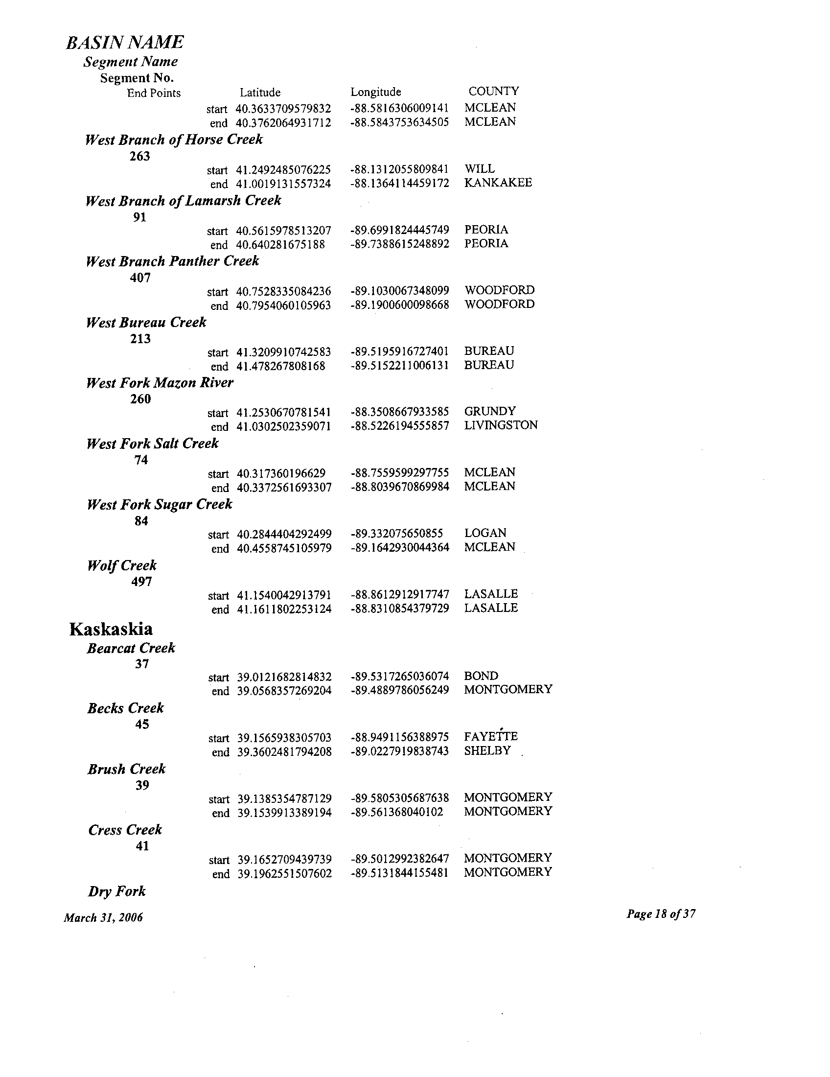
BASIN NAME
Segment Name
Segment No .
End Points
Latitude
start 40.3633709579832
Longitude
-88 .5816306009141
COUNTY
MCLEAN
end 40
.3762064931712 -88 .5843753634505 MCLEAN
West Branch of Horse Creek
263
start 41 .2492485076225 -88 .1312055809841
WILL
end 41 .0019131557324 -88 .1364114459172
KANKAKEE
West Branch ofLamarsh Creek
91
start 40 .5615978513207 -89
.6991824445749 PEORIA
end 40 .640281675188 -89 .7388615248892
PEORIA
West Branch Panther Creek
407
start 40 .7528335084236
-89 .1030067348099
WOODFORD
end 40 .7954060105963
-89 .1900600098668 WOODFORD
West Bureau Creek
213
start 41 .3209910742583 -89
.5195916727401 BUREAU
end 41
.478267808168 -89 .5152211006131 BUREAU
West Fork Mazon River
260
start 41
.2530670781541 -88 .3508667933585 GRUNDY
end 41 .0302502359071 -88
.5226194555857 LIVINGSTON
West Fork Salt Creek
74
start 40.317360196629 -88.7559599297755
MCLEAN
end 40.3372561693307
-88 .8039670869984 MCLEAN
West Fork Sugar Creek
84
start 40.2844404292499 -89
.332075650855 LOGAN
end 40.4558745105979
-89 .1642930044364
MCLEAN
Wolf Creek
497
start 41 .1540042913791
-88 .8612912917747 LASALLE
end 41
.1611802253124 -88
.8310854379729 LASALLE
Kaskaskia
Bearcat Creek
37
start 39.0121682814832 -89.5317265036074
BOND
end 39 .0568357269204 -89.4889786056249
MONTGOMERY
Becks Creek
45
start 39 .1565938305703
-88 .9491156388975 FAYE'ITE
end 39 .3602481794208 -89 .0227919838743
SHELBY
Brush Creek
39
start 39
.1385354787129 -89 .5805305687638
MONTGOMERY
end 39 .1539913389194 -89
.561368040102 MONTGOMERY
Cress Creek
41
start 39
.1652709439739 -89 .5012992382647
MONTGOMERY
end 39 .1962551507602
-89 .5131844155481
MONTGOMERY
Dry Fork
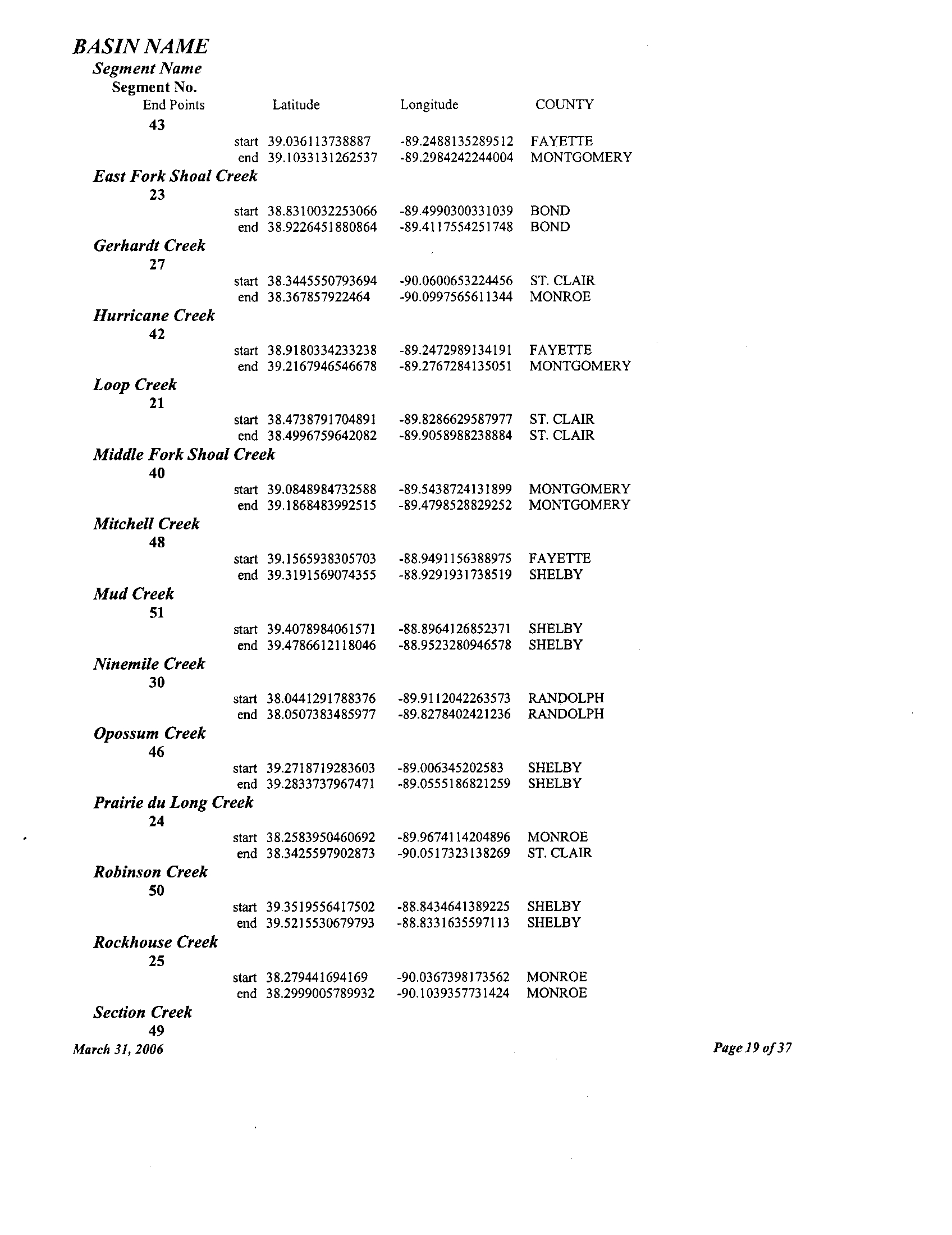
March 31, 2006
Page 18 of 37
BASIN NAME
Section Creek
49
March 31, 2006
Page 19 of 37
Segment Name
Segment No .
End Points
Latitude
Longitude
COUNTY
43
start 39 .036113738887 -89 .2488135289512 FAYETTE
end 39 .1033131262537 -89 .2984242244004 MONTGOMERY
East Fork Shoal Creek
23
start 38 .8310032253066 -89 .4990300331039 BOND
end 38 .9226451880864 -89.4117554251748
BOND
Gerhardt Creek
27
start 38 .3445550793694 -90.0600653224456 ST . CLAIR
end 38
.367857922464 -90.0997565611344 MONROE
Hurricane Creek
42
start 38 .9180334233238 -89 .2472989134191 FAYETTE
end 39 .2167946546678 -89 .2767284135051 MONTGOMERY
Loop Creek
21
start 38 .4738791704891 -89 .8286629587977 ST . CLAIR
end 38 .4996759642082
-89 .9058988238884 ST . CLAIR
Middle Fork Shoal Creek
40
start 39 .0848984732588 -89 .5438724131899 MONTGOMERY
end 39 .1868483992515 -89 .4798528829252 MONTGOMERY
Mitchell Creek
48
start 39 .1565938305703 -88
.9491156388975 FAYETTE
end 39 .3191569074355 -88 .9291931738519 SHELBY
Mud Creek
51
start 39 .4078984061571 -88 .8964126852371
SHELBY
end 39 .4786612118046 -88 .9523280946578 SHELBY
Ninemile Creek
30
start 38.0441291788376 -89 .9112042263573 RANDOLPH
end 38.0507383485977 -89.8278402421236 RANDOLPH
Opossum Creek
46
start 39.2718719283603 -89
.006345202583 SHELBY
end 39.2833737967471 -89.0555186821259 SHELBY
Prairie du Long Creek
24
start 38 .2583950460692 -89 .9674114204896 MONROE
end 38 .3425597902873
-90 .0517323138269 ST .CLAIR
Robinson Creek
50
start 39 .3519556417502 -88
.8434641389225 SHELBY
end 39 .5215530679793 -88 .8331635597113 SHELBY
Rockhouse Creek
25
start 38 .279441694169 -90 .0367398173562 MONROE
end 38 .2999005789932 -90 .1039357731424 MONROE
Burton Creek
192
March 31, 2006
Page20of37
BASIN NAME
Segment Name
Segment No .
End Points
Latitude
Longitude
COUNTY
start 39 .1835497280833 -88 .9455894742885 FAYETTE
end 39
.1959160048126 -88 .961892707007 FAYETTE
Shoal Creek
22
start 38 .4831106563982 -89 .5775456200079
WASHINGTON
end 38
.5557239981111 -89 .4968640710432 CLINTON
36
start 38 .8310032008922 -89 .4990300493802 BOND
end 39 .0848755752581
-89 .5439018081354 MONTGOMERY
Silver Creek
20
start 38 .3369025707936 -89
.8753691916515 ST . CLAIR
end 38 .5568068204478 -89 .8305698867169 ST
. CLAIR
Stringtown Branch
53
start 39.7138824796477
-88 .6677549810426 MOULTRIE
end 39.7363136714592 -88
.6944718913546 MOULTRIE
Unnamed Tributary of Gerhardt Creek
26
start 38 .367857922464 -90 .0997565611344
MONROE
end 38
.3742880966457 -90 .1107074126403 MONROE
Unnamed Tributary of Okaw River
54
start 39 .734248747064
-88 .6620801587617 MOULTRIE
end 39 .80990395294
-88 .6969360645412
PLATT
Walters Creek
28
start 38
.3425597902873 -90 .0517323138269 ST. CLAIR
end 38 .3445550793694 -90 .0600653224456
ST. CLAIR
West Fork Shoal Creek
38
start 39
.1385354787129 -89 .5805305687638
MONTGOMERY
end 39 .1877434015581
-89 .6041666305308 MONTGOMERY
West Okaw River
52
start 39
.6158126349278 -88 .7105522558061
MOULTRIE
end 39
.7564321977535 -88 .630211952428
MOULTRIE
Mississippi River
Apple River
372
start 42 .3210892387922 -90 .2520915343109
30 DAVIESS
end 42
.5078007598632 -90 .1320538371008
JO DAVIESS
Bear Creek
199
start 40 .1421908412793 -91 .322057103417
ADAMS
end 40
.3507607406412 -91 .1831593883194
HANCOCK
Bigneck Creek
205
start 40 .1189668648562 -91
.2247381726013 ADAMS
end 40 .118891177483 -91 .1409739765636
ADAMS
BASIN NAME
Ellison Creek
March 31, 2006
Page 21 of 37
Segment Name
Segment No .
End Points
Latitude
start 39 .8643091712617
Longitude
-91 .343323220756
COUNTY
ADAMS
end 39 .92393403238
-91
.2381482737218 ADAMS
Camp Creek
140
start 41 .2607621817314 -90 .514303172809
MERCER
end 41
.3114464274682 -90 .2476056448033 HENRY
142
start 41 .2202380211465 -90.895164796358
MERCER
end 41 .2787933006746
-90.6950345992843 MERCER
Carroll Creek
349
start 42 .1027782814517 -90.0265311556732
CARROLL
end 42 .0906369943302 -89.8985337135691 CARROLL
Clear Creek
6
start 37
.4821139304798 -89.377768200259 UNION
end 37 .5377402977406 -89.331689550578
UNION
381
start 42 .4468385101031 -90.0472460146999.
JO DAVIESS
end 42 .4780763391708
-90.035127804618 JO DAVIESS
Coon Creek
376
start 42.4035528739642 -90.1272819897867
JO DAVIESS
end 42.4347098804951
-90.1169407822902 JO DAVIESS
Copperas Creek
148
start 41 .3717279574558
-90.901871458269 ROCK ISLAND
end 41 .3616090539824 -90.7468725613692
ROCK ISLAND
Deep Run
155
start 40
.7779166934519 -90 .9639489255706 HENDERSON
end 40.794076798068 -90 .9474772904134
HENDERSON
DLvson Creek
154
start 40.7684181600505 -90 .9376123103323
HENDERSON
end 40.7650613473293
-90 .9262679175808 HENDERSON
Dutch Creek
4
start 37 .4593003249666 -89 .3688365937935 UNION
end 37.4147572383786
-89 .2744790735331 UNION
East Fork Galena River
383
start 42 .450241615252 -90 .3876497193745
JO DAVIESS
end 42.4876693698893
-90 .286894403861 JODAVIESS
Edwards River
145
start 41 .1459068953479 -90
.9832855425151 MERCER
end 41 .2835429634312 -90 .1022166001482
HENRY
Eliza Creek
146
start 41 .2754465656779 -90
.9740195834639 MERCER
end 41 .2948140261561 -90 .8870757880317
MERCER
BASIN NAME
McCraney Creek
March 31, 2006
Page 22 of 37
Segment Name
Segment No
.
End Points
Latitude
Longitude
COUNTY
153
start 40 .7615810139869 -91 .0723400800456
HENDERSON
end 40 .7295594797542 -90.7480413061409 WARREN
Galena River
382
start 42
.450241615252 -90.3876497193745 JO DAVIESS
end 42 .5068721036534 -90.390459616835
JO DAVIESS
Green Creek
5
start 37
.4514943718452 -89.3379244013686 UNION
end 37 .4666314694209
-89.3048476846202 UNION
Hadley Creek
188
start 39 .7025380326419 -91 .1396851101986
PIKE
end 39 .7351716794518 -90.9664567571417 PIKE
Hells Branch
378
start 42 .3582317355027
-90.185076448587 JO DAVIESS
end 42 .4166702490621 -90.1660286242329
JO DAVIESS
Henderson Creek
134
start 41 .0518601460692 -90.652709618504
WARREN
end 41 .0728998007979 -90.3331881878676 KNOX
150
start 40 .8788582366336 -90.9641994146698
HENDERSON
end 40 .989888583038 -90.8698875032336 HENDERSON
Hillery Creek
144
start 41 .2699394405307 -90.2020116075301
HENRY
end 41
.2553101029329 -90 .1954503442612 HENRY
Honey Creek
157
start 40 .7000823335975
-91 .0347691132118 HENDERSON
end 40 .7064734203141 -90 .8589436695132
HENDERSON
186
start 39 .4871465283426 -90
.7799240715991 PIKE
end 39 .5633421986505 -90 .8011460205638
PIKE
207
start 40 .1052246871151
-91 .2149469620062 ADAMS
end 40 .0689996865178 -91
.2253825583113 ADAMS
Hutchins Creek
7
start 37 .5043385818368 -89
.3755380391598 UNION
end 37 .58788138261
-89 .3917584202331 UNION
Little Bear Creek
194
start 40 .3213003292038 -91
.2390256840921 HANCOCK
end 40
.302753021887 -91 .3102530307924 HANCOCK
Little Creek
200
start 40 .1807360433073
-91 .2803860136891 ADAMS
end 40 .230127123031 -91 .3051461065984
HANCOCK
BASIN NAME
Segment Name
Segment No .
End Points
Latitude
Longitude
COUNTY
189
start 39 .7167396162723
-91 .1729844320811 PIKE
end 39 .8572624790589 -91 .0907175471865
ADAMS
Mill Creek
191
start 39
.8643091712617 -91 .343323220756 ADAMS
end 39 .9675786362521 -91
.2477003180771 ADAMS
377
start 42 .3539782358808
-90 .1879698650198 JO DAVIESS
end 42 .4518923573772 -90
.2485882677025 JO DAVIESS
496
start 38
.9472270910927 -90 .2956721236088 JERSEY
end 38 .9871246152411 -90
.3431576290565 JERSEY
Mississippi River
2
end 37.1887629940337 -89 .4576720472899
ALEXANDER
29
start 38 .8664117755941 -90 .1477786925267
MADISON
end 38 .327795025976 -90 .3709302644266
MONROE
384
start 42 .5079432477656 -90
.6430378486115 JO DAVIESS
end 41 .5746193723759 -90 .392321397091
ROCK ISLAND
440
start 39.326689248302 -90
.8243988873681 CALHOUN
end 39.8935238218567
-91 .4437639810547
ADAMS
Mud Creek
202
start 40.1812148450863 -91 .2785060826782
ADAMS
end 40.1852755387137 -91 .2660018265735
ADAMS
Nichols Run
156
start 40.7735451176215 -90 .9672827833242 HENDERSON
end 40.7648298879037 -90
.9675416302885 HENDERSON
North Henderson Creek
136
start 41 .0973619647032 -90 .7191141378965 MERCER
end
41 .119743833988 -90 .4494190524502 MERCER
Parker Run
141
start 41 .2623500459087 -90 .4891341819923 MERCER
end 41
.2260011828886 -90 .4145431241447 HENRY
Pigeon Creek
190
start 39 .7143204171354 -91 .2372670411405 PIKE
end 39
.8220301600964 -91 .2087922935523 ADAMS
Pope Creek
137
start- 41 .1401437091914 -90.8116816399802
MERCER
end 41 .1394137238591 -90.2877112230995 KNOX
Sixmile Creek
187
start 39 .4592604039597 -90.8902507134236
PIKE
end 39 .5431657559583 -90.8891598316201 PIKE
March
31, 2006
Page 23 of 37
BASIN NAME
Longitude
COUNTY
-91
.2423526162923 HANCOCK
-91 .2189777154329 HANCOCK
-90 .9146232873076 HENDERSON
end 40 .9291958384872 -90 .7919464822621
HENDERSON
South Edwards River
139
start 41
.2656645104853
-90 .2611866223557
HENRY
end 41 .1927071399434 -90
.0393078982573 HENRY
South Fork Apple River
-90 .0472460146999
JO DAVIESS
-89 .9845802036023
JO DAVIESS
203
start 40
.1677973436879 -91 .2933473698779
ADAMS
end 40 .0950329934447 -91
.0607522810856 ADAMS
South Henderson Creek
-90 .4811337762604 WARREN
-90 .4338464913801 KNOX
-90 .9641994146698
HENDERSON
-90 .8707263659685 HENDERSON
-89 .8985337135691 CARROLL
-89 .783599495409 CARROLL
-91 .234525810555
ADAMS
-91 .1501036788115
ADAMS
-91
.2447718289928 ADAMS
-91
.1658282439773 ADAMS
Unnamed Tributary ofApple
River
375
start 42
.3613497834653 -90 .1603277978963 JO DAVIESS
end 42 .3651703478401
-90
.1182227692179 JO DAVIESS
Unnamed Tributary of Bear Creek
197
start 40 .3187160045841
-91 .2379753573306 HANCOCK
end 40
.3220475782343
-91 .2218711128768 HANCOCK
201
start 40
.2483484763178 -91 .2634157983708 HANCOCK
end 40 .2576281291385 -91
.2420554576986 HANCOCK
Unnamed Tributary of Copperas Creek
149
start 41
.3759130587612 -90 .8569366994939 ROCK ISLAND
March 31, 2006
Page 24 of 37
135
start 41 .0188478643653
end 41 .0121123609019
151
start 40
.8788582366336
end 40 .8534764362853
Straddle Creek
301
start 42 .0906369943302
end 42 .1316680929413
Thurman Creek
204
start 40 .1277667094818
end 40 .1580795200863
Tournear Creek
193
start 39 .9042285951329
end 39 .8738503674823
Segment Name
Segment No .
End Points
Latitude
Slater Creek
198
start 40.291601584329
end 40.2822885732908
Smith Creek
152
start 40.9297989285848
380
start 42 .4468385101031
end
South Fork Bear Creek
42 .4176188464167
BASIN NAME
Segment Name
Segment No .
End Points
Latitude
end 41
.3735944469795
Longitude
-90 .829794872711
COUNTY
ROCK ISLAND
Unnamed Tributary of Furnace Creek
373
start 42 .3419228115146 -90 .2583358633166
JO DAVIESS
end 42 .3737126096251 -90 .2971522307335
JO DAVIESS
374
start 42 .3419228115146 -90 .2583358633166
JO DAVIESS
end 42 .3615209718591
-90 .24931703774 JO DAVIESS
Unnamed Tributary of South Edwards River
143
start 41 .2011516193172 -90 .1850818577344
HENRY
end 41 .1943841818099 -90 .1839265246101
HENRY
Unnamed Tributary of South Fork of Bear Creek
206
start 40 .0797919556019
-91 .1461193615862 ADAMS
end 40 .0587441356106
-91 .1467388825794 ADAMS
West Fork Apple River
379
start 42 .4777531846594 -90 .1103501186504
JO DAVIESS
end 42
.4739843218597 -90 .1321517307332 JO DAVIESS
West Fork of Bear Creek
195
start 40 .3385207135212
-91 .2203393068898 HANCOCK
end 40 .3592824400704 -91
.2334357995319 HANCOCK
Yankee Branch
147
start 41 .2850778212191
-90 .9379823025264 MERCER
end 41 .2926277702981 -90 .9335620769218
MERCER
Ohio
Big Creek
16
start 37 .4366764302436 -88 .3127424957005
HARDIN
end 37 .5591274535694
-88 .3148730216063 HARDIN
Big Grand Pierre Creek
13
start 37 .4163002207384 -88
.4338876873615 POPE
end 37 .5702304746463 -88 .4292613661871
POPE
Hayes Creek
10
start 37 .4452331751972 -88 .7114120959417
JOHNSON
end 37 .4559134065693 -88 .6286228702431 POPE
Hicks Branch
14
start 37 .5432903813926 -88
.4245265989312 POPE
end 37 .5391971894773 -88 .4135144509885
HARDIN
Little Lusk Creek
12
start 37 .4991426291527 -88
.5277357332102 POPE
end 37 .5247950767618 -88 .5017934865946
POPE
Little Saline River
9
start 37 .6429893859023
-88 .6229273282692 SALINE
March 31, 2006
Page 25 of 37
BASIN NAME
Segment Name
Segment No .
End Points
Latitude
end 37 .5783125058777
Longitude
-88 .7169929932876
COUNTY
JOHNSON
Lusk Creek
11
start 37.3685952948804
-88 .4926140087969 POPE
end 37 .5649232438096
-88 .5644984122843 POPE
Miss River
2
start 36 .9810279805712 -89 .1311552055554 ALEXANDER
Ohio River
1
start 36 .9810279805712
-89 .1311552055554 ALEXANDER
end 37 .7995447392016 -88
.0255709974801 GALLATIN
Simmons Creek
15
start 37 .4274681380208 -88 .4392381154217
POPE
end 37 .4644921054999 -88 .4850750109356 POPE
South Fork Saline River
8
start 37 .6372646144582
-88 .6447143188352 SALINE
end 37 .6650992000287 -88 .7471054185807
WILLIAMSON
Unnamed Tributary of Big Creek
18
start 37 .4816237108967 -88.3412279259479
HARDIN
end 37 .4836843600581
-88 .3434390004066 HARDIN
Wabash River
488
start 37 .7995447392016 -88.0255709974801
GALLATIN
Rock
Beach Creek
302
start 41 .8989215290323 -89 .121081932608
OGLE
end 41 .8637759544565 -89 .185844184387
LEE
Beaver Creek
322
start 42.2551087433884 -88 .9247700103803
BOONE
end 42.4341346635117
-88 .7603784300954 BOONE
Black Walnut Creek
341
start 42.1132080942552
-89 .2141520188153 OGLE
end 42.061557908797 -89 .2316600156935 OGLE
Brown Creek
335
start 42.3568412672282 -89 .4493817584574
STEPHENSON
end 42.3697340053709
-89 .4802304815634
STEPHENSON
Buffalo Creek
358
start 41 .9242552302868 -89 .6809355972221
WHITESIDE
end 41 .9752373833258
-89 .6243677263482 OGLE
Cedar Creek
337
start 42 .3709196286357 -89
.670256711355 STEPHENSON
end 42.3896058186609 -89 .5870343171161
STEPHENSON
March 31, 2006
Page26of37
BASIN NAME
Kingsbury Creek
311
March 31, 2006
Page27oJ37
Segment Name
Segment No .
End Points
Coal Creek
Latitude
Longitude
COUNTY
208
start 41 .3941767873198 -89 .8287586795479
BUREAU
end 41 .2930847238959 -89 .6659810678663
BUREAU
Coon Creek
304
start 42
.0365871032824 -89 .489365571257 OGLE
end 42 .0550520228278 -89
.4762995939105 OGLE
326
start 42 .254519734978
-88 .7945563884938 BOONE
end 42 .1336677087989 -88
.6039205825106 DEKALB
Crane Grove Creek
371
start 42
.2656461748962 -89 .6058461735176
STEPHENSON
end 42
.2317224844045 -89 .5804359629382 STEPHENSON
Deer Creek
307
start 42 .1046195671697 -88
.7267155451459 DEKALB
end 42 .1076541965304 -88 .6684575625598
DEKALB
Dry Creek
332
start 42 .4322162336943
-89 .0509181181504 WINNEBAGO
end 42 .4892211712754
-88 .9789486331688 WINNEBAGO
East Branch South Branch of Kishwaukee River
306
start 42 .0108038948242 -88 .7236807475971
DEKALB
end 41
.9822037358546 -88 .5449399063616 KANE
East Fork Mill Creek
343
start 42.1402053009442 -89 .2945061380348
OGLE
end 42.1744627607887
-89 .268245093523 OGLE
Elkhorn Creek
350
start 41 .8392614813286
-89 .6956810578758
WHITESIDE
end 42.0864514128748 -89
.636841111792 OGLE
Franklin Creek
303
start 41 .8885909580789
-89 .4120344682789 OGLE
end 41 .830393186845 -89 .3092915487959
LEE
Goose Creek
356
start 41
.9282951879448 -89 .692114617634
WHITESIDE
end 41 .9476422569681 -89
.6849104470831 OGLE
Green River
359
start 41 .6266589513433 -89 .5688644755145
LEE
end 41 .8177589430141
-89 .1263088319088
LEE
Kilbuck Creek
312
start 42 .1838622639314 -89 .1301689015062
WINNEBAGO
end 41 .9181917577798
-88 .9212387567239 DEKALB
BASIN NAME
Otter Creek
March 31, 2006
Page 28 of 37
Segment Name
Segment No .
End Points
Latitude
start 42 .1077794424363
Longitude
-88 .8726630666396
COUNTY
DEKALB
end 42.1579325310556 -88 .8548684690422 BOONE
Kishwaukee River
318
start 42 .1866384939252 -89.1320796977525 WINNEBAGO
end 42 .2666635150817 -88
.5250450377336
MCHENRY
Kyle River
295
start 41 .9881250432719 -89 .3232327202272 OGLE
end 41
.9206998470585 -89 .0576692414087 OGLE
Leaf River
345
start 42 .093677393629 -89
.3249228482157 OGLE
end 42 .1545774626081 -89
.5725820219443 OGLE
Lost Creek
368
start 42.245723132043 -89.7807765552299 STEPHENSON
end 42 .2314500223394 -89 .7709518073782 STEPHENSON
Middle Creek
344
start 42.1559584011258 -89
.2911997709031 OGLE
end 42.1737499306461 -89.2931763612625 OGLE
Mill Creek
342
start 42 .1206847838382 -89 .2792143996076 OGLE
end 42.2092574596508 -89.3358557551327 WINNEBAGO
Mosquito Creek
323
start 42.3066628798583 -88 .9047855300292 BOONE
end 42.3100003482313
-88 .9099328193755 BOONE
327
start 42 .246521748985 -88 .7802719043895 BOONE
end 42
.1906300595167 -88 .7849304281662 BOONE
Mud Creek
325
start 42 .2592878387497 -88 .7503449689069
BOONE
end 42 .2805097009077 -88 .7381130663589 BOONE
346
start 42 .1301628959448 -89 .4043328758949
OGLE
end 42 .1639762007661 -89 .4554911246235
OGLE
North Branch Kishwaukee River
320
start 42 .2655855837644 -88 .5514660318739 MCHENRY
end 42 .4163330454161 -88 .5232715616737 MCHENRY
North Branch Otter Creek
292
start 42 .4412940471901 -89 .3074016078782 WINNEBAGO
end 42
.4570625094589
-89
.356265092275 WINNEBAGO
North Fork Kent Creek
333
start 42 .2621663352674 -89 .0944316410734 WINNEBAGO
end 42 .310438304708 -89 .1651357273603 WINNEBAGO
BASIN NAME
Segment Name
Segment No .
End Points
Latitude
Longitude
COUNTY
291
start 42 .4565457866811 -89 .2410171137247
WINNEBAGO
end 42 .4412940471901 -89 .3074016078782 WINNEBAGO
348
start 42 .1345277930786 -89.411492883497 OGLE
end 42 .1911608097275 -89.4222625773931 OGLE
Owens Creek
310
start
42
.1012605056104 -88 .8850996053184 DEKALB
end 41 .994362186304 -88.8506687869106 DEKALB
Pine Creek
305
start 41 .9113031895505 -89.452879176459 OGLE
end
42
.0376146514025 -89.4909007464322 OGLE
Piscasaw Creek
324
start 42 .2618063936707 -88.8176068924198
BOONE
end 42 .3916885547221 -88 .7041339551642 MCHENRY
Raccoon Creek
328
start
42
.4479288873423
-89.098286193015
WINNEBAGO
end 42 .4829761640917 -89.1400856130022
WINNEBAGO
Reid Creek
353
start 41 .8644109921615 -89.5919014348703 LEE
end 41 .9135187969506 -89.5728723309406 OGLE
Richland Creek
336
start 42 .3456275295301 -89.6832413426115 STEPHENSON
end 42 .5047442687577 -89 .6477619118761 STEPHENSON
Rock River
294
start 41 .9881250432719 -89 .3232327202272 OGLE
end 42 .4962174640048 -89 .0418910839077 WINNEBAGO
Rock Run
490
start 42.3211872463585 -89 .4237342452712
STEPHENSON
end 42 .4281098959774 -89 .4483616268915 STEPHENSON
Rush Creek
321
start 42.2560676137827
-88 .7031592940742 MCHENRY
end 42.4031741332744 -88 .5930626223964
MCHENRY
Silver Creek
338
start 42.0611717976691 -89.335901928201 OGLE
end 42.0866765435436 -89.3839889015445
OGLE
Skunk Creek
354
start 41.8794703976699 -89.7072621672884 WHITESIDE
end 41.897582187238 -89.7290746844729
WHITESIDE
South Branch Kishwaukee River
308
start 42.2001609257306 -88.9840657029051
WINNEBAGO
March 31, 2006
Page 29 of 37
BASIN NAME
Segment Name
Segment No .
End Points
Latitude
end 41
.9015798699947
Longitude
-88 .7706697182685
COUNTY
DEKALB
315
start 42
.2627093767756 -88
.5609522875415 MCHENRY
end 42 .1066209842679
-88 .4620443477841
KANE
South Branch of Otter Creek
280
start 42 .4412940471901
-89 .3074016078782
WINNEBAGO
end 42
.4343122756071 -89
.3600650183381 WINNEBAGO
South Fork of Leaf River
347
start 42 .1296104494647
-89 .4546456401589
OGLE
end 42 .1085718337046
-89 .5037134270228 OGLE
South Kinnikinnick Creek
330
start 42
.419961259532 -89
.018119476068 WINNEBAGO
end 42
.4190921988888 -88 .8710507717794
BOONE
Spring Creek
339
start 42 .0709215390383
-89.325546679708 OGLE
end 42.0590157098796 -89.3110803788049
OGLE
Spring Run
313
start 42.0402370001041
-89 .0065478421579
OGLE
end 42
.0507770466662 -88 .9858854279893
OGLE
Steward Creek
297
start 41
.8903673258897 -89
.1021064698423 OGLE
end 41 .8259979751563
-88 .9624738458404
LEE
Stillman Creek
340
start 42
.1259475370515 -89
.2319193482332 OGLE
end 42
.0372051268587 -89 .1542573242497
OGLE
Sugar Creek
352
start 41 .8392614813286
-89 .6956810578758
WHITESIDE
end 41 .8644109921615
-89 .5919014348703 LEE
Sugar River
293
start 42 .4357992567436 -89
.1971727593158
WINNEBAGO
end 42
.4982890047043 -89 .2624235677856
WINNEBAGO
Sumner Creek
334
start 42
.3227762010459 -89
.3830042631004 WINNEBAGO
end 42 .25195988987
=89 .3997975146614
STEPHENSON
Turtle Creek
329
start 42 .4929910323531
-89
.0439958173493 WINNEBAGO
end 42 .4961371053418
-89 .0246519221989 WINNEBAGO
Unnamed Tributary
361
start 41
.6608316904842 -89
.4728200038511 LEE
end 41 .6425311558513
-89 .4137140926471
LEE
365
March 31, 2006
Page 30 of 37
BASIN NAME
Segment Name
Segment No .
End Points
Latitude
start 41 .7443681625006
Longitude
-89 .168951821186
COUNTY
LEE
end 41 .738182745458 -89 .1042187039322 LEE
492
start 42 .1246069284208 -88 .5882544654343
DEKALB
end 42 .1028295788327 -88 .5105326912596 KANE
Unnamed Tributary of Buffalo Creek
357
start 41 .9332348110612
-89 .6342816030603 OGLE
end 41 .93890647032
-89 .6092042883405 OGLE
Unnamed Tributary of Coon Creek
282
start 42
.1336677087989 -88 .6039205825106 DEKALB
end 42 .0754334787177 -88
.5442273447775 KANE
491
start 42 .150113155436
-88 .6091713292612 DEKALB
end 42 .1691790844289 -88
.5070973943593 MCHENRY
Unnamed Tributary ofElkhorn Creek
355
start 41 .9378871254405 -89
.7318712136894 CARROLL
end 41 .9525180771018 -89 .7332762139612 CARROLL
Unnamed Tributary of Green River
360
start 41 .8177589430141
-89 .1263088319088 LEE
end 41 .8012094828667 -89 .0296681468724
LEE
362
start 41
.66455888603
-89 .4729486542104 LEE
end 41 .650155479351 -89 .4398464027055
LEE
364
start 41 .750735979575 -89 .2189268880904
LEE
end 41 .7278383993539 -89 .1577958588247 LEE
366
start 41 .7304138832457 -89 .2547363744761
LEE
end 41
.7421804770435 -89 .2683034846455 LEE
367
start 41 .7336722733557 -89 .2459381167869
LEE
end 41 .6996843512729 -89 .2025409068097
LEE
489
start 41 .7765356433433 -89
.1781811586274 LEE
end 41 .791148742648 -89
.1782543204659 LEE
Unnamed Tributary ofKyte River
298
start 41
.969037423435 -89 .2727932207785 OGLE
end 41
.9423468128644 -89 .2676252361535 OGLE
299
start 41
.9474122868214 -89 .1742920304606 OGLE
end 41 .9511979792854
-89 .1378721025283 OGLE
Unnamed Tributary of North Branch Kishwaukee River
319
start 42 .4163330454161 -88 .5232715616737
MCHENRY
end 42 .4218523642031
-88 .5063783493938 MCHENRY
Unnamed Tributary of Rock River
331
start 42 .3730089457359 -89 .0581319432428
WINNEBAGO
March 31, 2006
Page 31 of 37
BASIN NAME
Brouilletts Creek
March 31, 2006
Page 32 of 37
Segment Name
Segment No .
End Points
Latitude
end 42 .382841503485
Longitude
-89 .0950184603254
COUNTY
WINNEBAGO
Unnamed Tributary of South Branch Kishwaukee River
309
start 42 .1219922946716 -88
.9236557341498 DEKALB
end 42 .1138208388943
-88 .9372243118963
DEKALB
316
start 42
.1565644453666 -88 .4449935784875
MCHENRY
end 42 .1594149792506
-88 .4178533576301
MCHENRY
317
start 42 .234010247227
-88 .5199093723576
MCHENRY
end 42 .2225793216803
-88 .5259266256801 MCHENRY
Unnamed Tributary of Spring Run
314
start 42
.0401565844742 -88
.9948863767949 OGLE
end 42.0116835703089
-88 .9710672286801
OGLE
Unnamed Tributary of Steward Creek
296
start 41 .8444592840822
-89 .0070046248547 LEE
end 41
.8601589546913 -88
.9714244440014 LEE
300
start 41 .871719116543
-89 .069434926448
LEE
end 41 .8792477545579 -89
.037635229652 LEE
Unnamed Tributary of Yellow Creek
369
start 42
.3067615221991 -89 .8535571166391
STEPHENSON
end 42.3493669268537
-89 .8275355259147
STEPHENSON
West Fork Elkhorn Creek
351
start 42
.0864514128748 -89 .636841111792
OGLE
end 42 .0924853439498
-89 .6474944357754
OGLE
Willow Creek
363
start 41 .7653209616214
-89 .1943294683724 LEE
end 41 .7141851660088
-89 .032161004274
LEE
Yellow Creek
370
start 42
.2899156684427 -89 .5696276563017
STEPHENSON
end 42 .3796215769162
-89 .9350879560031
JO DAVIESS
Wabash
Bean Creek
437
start 40.2950579779894
-87 .7823902126108
VERMILION
end 40.3344744135429 -87
.7494458762005 VERMILION
Big Creek
457
start 39 .3351439545995 -87.5878012286214
CLARK
start 39 .436126036547 -87.7023848396263
CLARK
Bluegrass Creek
436
start 40
.301292752824 -87.7969361668719
VERMILION
end 40 .381268589802
.87.8562389558508
VERMILION
BASIN NAME
Dudley Branch
475
March 31, 2006
Page 33 of 37
Segment Name
Segment No .
End Points
450
Latitude
Longitude
COUNTY
start 39 .7057649552945
-87 .5509615193818 EDGAR
end 39 .797449971524 -87 .7178559181463
EDGAR
Brush Creek
468
start 38
.993072718826 -88 .1273817532169
JASPER
end 38 .9675510537677
-88 .1471375817992 JASPER
Brushy Fork
484
start 39
.7161188745587 -88 .0853294840712
DOUGLAS
end 39
.8111289403664 -87 .8839288887749
EDGAR
Buck Creek
435
start 40 .3115126234324
-87 .9255710854089 VERMILION
end 40 .2862675329103 -87
.9704593374522 CHAMPAIGN
Cassell Creek
473
start 39
.4866434423672 -88 .2094970436354
COLES
end 39 .4909698054293
-88 .207848854172 COLES
Catfish Creek
477
start 39 .680891264864 -87
.9341744320393 EDGAR
end 39 .6581354970801 -87 .8937116601235
EDGAR
Clark Branch
483
start 39 .8111289403664
-87 .8839288887749
EDGAR
end 39 .8226610039489 -87
.8513747624001 EDGAR
Collison Branch
439
start 40 .2351860050982
-87.7725365689525
VERMILION
end 40 .2197161120333 -87
.803155121171 VERMILION
Cottonwood Creek
469
start 39 .2033657707304 -88
.2765033266093 CUMBERLAND
end 39
.3142137713574 -88 .229342077034
CUMBERLAND
Crabapple Creek
452
start 39 .7057649552945 -87.5509615193818
EDGAR
end 39 .8065708276187
-87.6467768455628
EDGAR
Crooked Creek
465
start 38 .9817031629594 -88
.066438923761 JASPER
end 39
.0356467346919 -88.0923368283887
JASPER
Deer Creek
485
start 39 .7053403128076
-88.0850387247647
DOUGLAS
end 39.7025679945443 -88
.2058470030399 DOUGLAS
Donica Creek
479
start 39 .6453315324326
-87 .9892294370803
COLES
end 39
.6172623271272 -87
.9782640861296 COLES
BASIN NAME
Segment Name
Segment No .
End Points
Latitude
Longitude
-88 .0564563693231
COUNTY
start 39.5115642227627
COLES
end 39 .5068188298145
-88 .043669581567
COLES
East Crooked Creek
287
start 39 .0356467346919 -88
.0923368283887 JASPER
end 39
.1659729856615 -88 .0610310241876
JASPER
East Fork Big Creek
458
start 39 .436126036547
-87 .7023848396263 CLARK
end 39 .5471103780713
-87 .760040304497 EDGAR
Embarras River
460
start 38 .9148628762488 -87 .9834798036322
JASPER
end 39 .7161188745587
-88 .0853294840712 DOUGLAS
Feather Creek
432
start 40 .1172818042134 -87.8342855159987
VERMILION
end 40 .1416543211304 -87.8399367268356
VERMILION
Greasy Creek
480
start 39
.6325904592965 -88 .0822649850404
COLES
end 39 .6182255297223
-88 .1320998047424 COLES
Hickory Creek
464
start 38 .9714278418083 -87.972721454297
JASPER
end 38
.99191464315
-87 .989292523907 JASPER
Hickory Grove Creek
478
start 39 .6581354970801 -87
.8937116601235 EDGAR
end 39 .5712873627184 -87.8825676201308
EDGAR
Hurricane Creek
470
start 39 .2889007816578
-88 .1544749600653
CUMBERLAND
end 39 .3793118297358 -88
.0668208708762 COLES
Jordan Creek
433
start 40
.0794151192358 -87 .7990673709556
VERMILION
end 40 .0588834821927 -87 .8360461636444
VERMILION
443
start 40.3360527696651
-87 .6231745570584
VERMILION
end 40 .3553265493525 -87 .5278198412106
VERMILION
Kickapoo Creek
471
start 39 .4379695819539
-88 .1681483569976 COLES
end 39 .4597583113682 -88 .2917593820249
COLES
Knights Branch
438
start 40 .2763499940372
-87 .7961879249888
VERMILION
end 40 .2520446574291
-87 .8336356533235 VERMILION
Little Embarras River
476
start 39
.5736361588448 -88 .0726889440362
COLES
end 39 .680891264864
-87 .9341744320393 EDGAR
March 31, 2006
Page 34 of 37
BASIN NAME
South Fork Brouilletts Creek
453
March 31, 2006
Page 35 of 37
Segment Name
Segment No .
End Points
Latitude
Longitude
COUNTY
Little Vermilion River
426
start 39 .9463345271443 -87 .5536756201362 VERMILION
end 39 .9593741043792 -87 .6447473681732 VERMILION
Middle Branch
442
start 40.3096675860339 -87 .6376716065503
VERMILION
end 40.417753327133 -87 .5275419211693 VERMILION
Middle Fork Vermilion River
428
start 40.1035656386662
-87 .7169902321166 VERMILION
end 40.4043343147541 -88 .0191381621282
FORD
Mill Creek
487
start 39 .2394256838229 -87 .6762126527038 CLARK
end 39 .3566749194214 -87 .7425049309309 CLARK
Muddy Creek
242
start
39 .1821395682335 -88 .2309155529877 CUMBERLAND
end 39 .2033657707304 -88 .2765033266093
CUMBERLAND
North Fork ofEmbarras River
461
start 38 .9148628762488 -87.9834798036322 JASPER
end 39 .0924749553725 -87.9784039128617
JASPER
North Fork Vermilion River
441
start 40.236054881277 -87.6293326109766
VERMILION
end 40 .5010729612407 -87.5261721834388 IROQUOIS
Panther Creek
462
start 39 .0924749553725 -87 .9784039128617
JASPER
end 39 .184289386946 -88 .0087906828419 CUMBERLAND
Polecat Creek
474
start 39 .5013303165832 -88 .1055006912296 COLES
end 39 .5162859310237
-88 .0338496162262 COLES
Riley Creek
472
start
39
.4712869216685 -88 .2108945161318 COLES
end 39 .5116227820733 -88 .2569469311765
COLES
Salt Fork
429
start 40 .1035656386662 -87 .7169902321166 VERMILION
end 40
.0368232483006 -88 .0746580039075 CHAMPAIGN
455
start 39 .7425080214619 -87 .572919448772 EDGAR
end 39
.8018493662144 -87 .5775868051385 EDGAR
Snake Creek
454
start 39 .7128111863363 -87 .6415954465778 EDGAR
end 39 .7066978623237
-87 .6543043306751 EDGAR
BASIN NAME
March 31, 2006
Page 36 of 37
Segment Name
Segment No.
End Points
Latitude
start 39 .7256495590209
Longitude
-87 .6437626049444
COUNTY
EDGAR
end 39 .7319449005729 -87 .6951881181821 EDGAR
Stony Creek
431
start 40 .0943454186494 -87 .8170769835194 VERMILION
end 40 .1548847864725 -87.8840063394108 VERMILION
Sugar Creek
456
start 39 .4838820536199 -87 .5320762217325 EDGAR
end 39 .6298164781408 -87 .6762882912482 EDGAR
Unnamed Tributary of Big Creek
459
start 39 .5047911835054 -87 .7121475341945 EDGAR
end 39 .5692784693864 -87 .7194139533441 EDGAR
Unnamed Tributary ofBrouilletts Creek
451
start 39 .797449971524 -87 .7178559181463 EDGAR
end 39 .831592697221 -87
.7758036967074 EDGAR
Unnamed Tributary of Brushy Fork
482
start 39 .7340344129883 -88 .0771406153965 DOUGLAS
end 39 .802586616189 -88 .0753634663247 DOUGLAS
Unnamed Tributary of Deer Creek
486
start 39 .7102184848625 -88 .1385435180688 DOUGLAS
end 39 .678866903649 -88 .1425332064637 DOUGLAS
Unnamed Tributary of Embarras River
467
start 38 .9934159067144 -88 .129258689394 JASPER
end 39 .0034725453128 -88 .1210073578163 JASPER
Unnamed Tributary of Greasy Creek
481
start 39 .6182255297223 -88 .1320998047424 COLES
end 39 .621059195964 -88 .1538483534688 COLES
Unnamed Tributary of Hickory Creek
210
start 38 .99191464315
-87 .989292523907 JASPER
end 39 .0117394234421 -87 .9896104862878 JASPER
Unnamed Tributary of Middle Fork Vermilion River
434
start 40 .3478602982847 -87 .9479087836067 CHAMPAIGN
end 40 .3408935605508 -87 .9885982351498
CHAMPAIGN
Unnamed Tributary of Stony Creek
430
start 40.1548847864725 -87.8840063394108
VERMILION
end 40.1706704853124 -87 .9033972187304 VERMILION
Unnamed Tributary or North Fork of the Vermilion River
444
start 40.3553498759616 -87 .6852979017427 VERMILION
end 40 .3665727663496 -87 .733231992072 VERMILION
445
start 40 .483638183168 -87 .5751075709757 VERMILION
end 40 .4930209841439 -87 .5771391859822 IROQUOIS
B, 4SIN NAME
March 31, 2006
Page 37 of 37
Segment Name
Segment No .
End Points
Latitude
Longitude
COUNTY
446
start 40.423223711311 -87
.6788932053507 VERMILION
end 40.4280461995299
-87.6895565256772 VERMILION
Vermilion River
427
start 40 .0116868805566 -87.5337540394346 VERMILION
end 40 .1035656386662
-87.7169902321166 VERMILION
Wabash River
488
end 39 .3034266238732 -87 .605592332246 CLARK
West Crooked Creek
466
start 39.0356467346919 -88 .0923368283887
JASPER
end 39 .0545759701349
-88 .1009871944535 JASPER
West Fork Big Creek
19
start 39.436126036547 -87 .7023848396263 CLARK
end 39.5012337820195 -87 .8003199656505
EDGAR
Willow Creek
463
start 39 .0191952007294 -87.9402449982878
CRAWFORD
end 39 .0529145507759 -87.9280073176635 CRAWPORD
I
Recommended Revisions to the
Illinois General Use Water-Quality Standard for Dissolved Oxygen
March 31, 2006
by
Illinois Department of Natural Resources
and
Illinois Environmental Protection Agency
Overview of recommended revisions to the Illinois water-quality standard for
dissolved oxygen
In April 2004, the Illinois Association of Wastewater Agencies proposed revisions to the General
Use water-quality standard for dissolved oxygen
(In the matter of
: Proposed Amendments to
Dissolved Oxygen Standard,
35 Ill . Adm
. Code 302.206, R-04-25)
. In response to this proposal,
the Illinois Department of Natural Resources (Illinois DNR) and the Illinois Environmental
Protection Agency (Illinois EPA) recommend alternative revisions of the dissolved oxygen
standard
. Illinois DNR and Illinois EPA believe that the current standard for Illinois General
Use waters is too simplistic
; it inadequately accounts for the varied dissolved oxygen
requirements of aquatic life in these waters
. The current standard also inadequately accounts for
how dissolved oxygen concentrations vary across a broad range of natural aquatic conditions
throughout Illinois.
To replace the current General Use dissolved oxygen standard, Illinois DNR and Illinois EPA
recommend two levels of standards, each level applying to one of two sets of waters in Illinois
.
One level applies to the large majority of General Use waters and is designed to ensure sufficient
oxygen concentrations for the aquatic life therein
. Another higher level of standards applies to a
small, selected subset of General Use waters
; these thresholds are designed to protect Illinois'
most sensitive types and life stages of aquatic life that require relatively higher dissolved oxygen
concentrations
. Illinois DNR and Illinois EPA identify about 8% of the length of Illinois' 71,394
stream miles as requiring these higher dissolved oxygen levels (based on stream miles in the U
.S.
Geological Survey National Hydrography Dataset
; see internet website : //nhd.usgs.gov/)
. The
1
recommended numeric standards for each of these two sets of General Use waters are based
primarily on the U .S
. Environmental Protection Agency (USEPA) national-criteria document,
"Ambient Aquatic Life Water Quality Criteria for Dissolved Oxygen (Freshwater)" (USEPA
1986)
. Illinois DNR and Illinois EPA use this document as a foundation from which to interpret
and incorporate more-recent information specifically applicable to the dissolved oxygen needs'of
aquatic life in Illinois waters .
The revisions to the current dissolved oxygen standard proposed by the Illinois Association of
Wastewater Agencies (IAWA) are also based on the USEPA (1986) national-criteria document
;
however, Illinois DNR's and Illinois EPA's recommended revisions differ from those of IAWA
in the following primary ways (Figure 1):
1) Illinois DNR and Illinois EPA define two levels of numeric standards, with a higher level that
provides enhanced protection in waters that have organisms especially sensitive to low
dissolved oxygen levels
. IAWA's proposed revisions make no such distinction
.
2) Illinois DNR and Illinois EPA provide a narrative standard for waters that naturally cannot
achieve consistently higher levels of dissolved oxygen, e.g.,
wetlands, sloughs, river
backwaters, and lakes and reservoirs below the thermocline
. IAWA's proposed dissolved
oxygen standards apply universally to all General Use waters
(In the matter of: Proposed
Amendments to Dissolved Oxygen Standard,
35 Ill . Adm
. Code 302
.206, R-04-25, Exhibit 1,
April 19, 2004) .
2
3) Illinois DNR and Illinois EPA recommend a longer period for the protection of early life
stages of fish : March through July. IAWA's early-life-stage period is March through June .
4) Consistent with USEPA (1986), Illinois DNR and Illinois EPA include a 30-day chronic
dissolved oxygen standard, i.e., daily mean averaged over 30 days . IAWA does not include
a 30-day chronic standard.
3
General Use
Waters
Dissolved Oxygen Standards Recommended by Illinois DNR/EPA
Wetlands, sloughs, river backwaters, lakes below thermocline, etc
. are protected by a narrative standard.
Dissolved Oxygen Standards Proposed by IAWA
Early Life Stages of Fish
:
Figure 1 . Comparison between dissolved oxygen standards recommended by Illinois DNR/Illinois EPA and those proposed by
IAWA.
Level 1
(enhanced protection)
Level 2
Early Life Stages of Fish
:
Early Life Stages of Fish :
Present
(March - July)
Absent
(August - Feb.)
Present
(March
- July)
Absent
(August - Feb.)
Daily Minimum
5
.0
4 .0
5 .0
3 .5
7-day Mean of
Daily Minima
4 .5
4
.0
7-day Mean of
Daily Means
6 .25
6 .0
30-day Mean of
Daily Means
6.0
5 .5
Present
(March - June)
Absent
(July - Feb.)
Daily Minimum
5 .0
3 .5
7-day Mean of
Daily Minima
4
.0
7-day Mean of
Daily Means
6.0
30-day Mean of
Daily Means
USEPA's water-quality criteria for dissolved oxygen provide a sound,
scientific foundation
Illinois DNR and Illinois EPA primarily base the recommended revisions to dissolved oxygen
standards on information in USEPA (1986), which provides a sound, scientifically based
foundation
. The USEPA (1986) criteria for dissolved oxygen address three critical elements not
addressed by the current Illinois standard
. First, the USEPA criteria account for differences in
sensitivity to low dissolved oxygen among types of fishes or macroinvertebrates . Second, the
USEPA criteria account for differences in sensitivity among life stages of fish . Third, the
USEPA criteria provide practical considerations that account for occasional natural occurrences
of low dissolved oxygen
. Incorporation of these elements greatly improves the utility of the
Illinois standards .
Illinois DNR and Illinois EPA recognize some limitations in using the information in USEPA
(1986) to revise Illinois dissolved oxygen standards
; therefore, these recommended standards
revisions are supported further by more-recent information that pertains specifically to aquatic
life in Illinois waters
. In general, to determine how the USEPA (1986) criteria apply in Illinois,
Illinois DNR and Illinois EPA address two primary questions
:'
1) Are the USEPA (1986) dissolved oxygen criteria sufficient for protecting the
most sensitive (to low dissolved oxygen) of the numerous types and life stages of fish and
macroinvertebrates that live in Illinois waters?
5
2) If not, then what alternative dissolved oxygen criteria would ensure sufficient
protection and in which Illinois waters should these higher criteria apply?
How the basic structure of USEPA criteria for dissolved oxygen applies to
Illinois dissolved oxygen standards
USEPA (1986) accounts for differences in dissolved oxygen sensitivity among types of fish or
macroinvertebrates by providing two different levels of dissolved oxygen criteria, labeled as
:
"coldwater" vs . "warmwater"
. USEPA (1986) states,
"Criteria for coldwater fish are intended to
apply to waters containing a population of one or more species in the family Salmonidae (Bailey
et al
. 1970) or to waters containing other coldwater or coolwater fish deemed by the user too be
closer to salmonids in sensitivity than to most warmwater species
. . . The warmwater criteria
are
necessary to protect
early life stages of warmwater fish as sensitive as channel catfish
and to
protect
other life stages of fish as sensitive as largemouth bass"
(p. 33; emphasis added)
. These
limits on
the applicability of USEPA's "warmwater" criteria provide the primary basis for much
of the discussion that follows in this document
. Additional to differences among species,
USEPA (1986) accounts for differences in dissolved oxygen sensitivity based on a fish's life
stage : early life stages vs
. other
. Overall, USEPA's (1986) approach results in four sets of
dissolved oxygen criteria (Table 1, columns 4, 5, 8, and 9)
.
Based on the information available at the time, USEPA's four categories of dissolved oxygen
criteria represented a practicable way of accounting for how different types and life stages of
6
aquatic life were known to differ in their sensitivity to low dissolved oxygen
. Illinois' current
water-quality standard for dissolved oxygen was developed and adopted before 1986 (Illinois
Pollution Control Board 1972)
; it does not account for these differences
. Therefore, revising
Illinois' current dissolved oxygen standard begins with evaluating how the USEPA (1986)
criteria apply to Illinois waters
. By carefully considering the strengths and limitations of
USEPA's (1986) dissolved oxygen criteria, Illinois DNR and Illinois EPA believe that these
nationally recommended criteria can be used as the basic framework for determining the most-
appropriate standards for protecting aquatic life in Illinois
. Illinois DNR and Illinois EPA build
on this framework by incorporating information that has become available since 1986 and that
pertains more directly to the many types of fish and macroinvertebrates that inhabit Illinois
waters.
Recommended dissolved oxygen standards to protect aquatic life in Illinois
For the large majority of Illinois General Use waters (Level 2 in Figure 1), the dissolved oxygen
standards recommended by Illinois DNR and Illinois EPA reflect the USEPA (1986) criteria
(Table 1)
. For a small subset of General Use waters (Level 1 in Figure 1), Illinois DNR and
Illinois EPA recommend the following
. Based on the sensitivities of Illinois fishes and
macroinvertebrates to low dissolved oxygen, Illinois DNR and Illinois EPA recommend a "daily
minimum" (acute) dissolved oxygen standard of 4
.0 mg/l to protect Illinois aquatic life that are
most sensitive to low dissolved oxygen when early life stages of fish are absent (Table 1, column
7)
. This threshold concentration is based primarily on protecting the most-sensitive
macroinvertebrates and is consistent with USEPA's (1986) recommendation
. "In summarizing
7
the state of knowledge regarding the relative se sitivity offish and invertebrates to low dissolved
oxygen, it seems that some species of insects and other crustaceans are killed at concentrations
survived by all species offish tested
. Thus, while most fish will survive exposure to 3 mg/1, many
species of invertebrates are killed by concentrations as high as 4 mg/1" (USEPA 1986, p. 23) .
For the same small subset of General Use waters (Level 1 in Figure 1), Table 1 (columns 6 and
7) shows Illinois DNR's and Illinois EPA's recommendations for chronic dissolved oxygen
standards. Using fish-species' relative chronic sensitivities (Rankin 2004) and some limited
information for macroinvertebrates-but lacking specific information about chronic thresholds
for the large majority of Illinois organisms-Illinois DNR and Illinois EPA recommend chronic
standards that represent a practical balance
. This balance primarily reflects that several Illinois
fish species are intermediate in chronic sensitivity between sensitive salmonids (i .e., trout,
salmon) and the two less sensitive species used as benchmarks for the USEPA (1986)
"warmwater" criteria (i.e., largemouth bass, channel catfish) . Consequently, Illinois DNR and
Illinois EPA simply select dissolved oxygen concentrations halfway between the USEPA (1986)
"coldwater" and "warmwater" chronic levels
. For example, for the period when early life stages
are absent, the USEPA "coldwater" threshold for the 7-day mean of daily minima is 5
.0 mg/I,
and the analogous "warmwater" threshold is 4 .0 mg/l . Illinois DNR and Illinois EPA select the
midpoint, 4 .5 mg/I (Table 1, column 7), as
the threshold for "intermediate" waters-which were
selected based on the approach explained later in this document
.
8
Table 1
. Allowable minimum concentrations of dissolved oxygen for the protection of aquatic life
. Thresholds shown are those recommended
either by USEPA (1986) or jointly by Illinois DNR and Illinois EPA
. Different minima apply for each of three types of aquatic habitat, based on
the relative sensitivity to low dissolved oxygen of the animal life therein
: "coldwater" vs . intermediate vs
. "warmwater"
. For each type of habitat,
minima are also stratified by time period, based on the presence of early life stages of fish
. For particular situations not indicated in the table
(e.g .,
manipulable discharges), alternative USEPA minima may apply (see USEPA [1986] pp
. 34 and 37-38) .
Habitats of Organisms
Intermediate in Sensitivity to Low
Dissolved 0 en
Illinois General Use Waters
(column 6)
(column 7)
(column 8)
(column 9)
"Daily
minimum" is the minimum dissolved oxygen concentration that occurs during a single calendar day .
23
"Daily
These bounds
mean" is
are
the
recommended
arithmetic
by
mean
Illinois
of dissolved
DNR and
oxygen
Illinois
concentrations
EPA only
;
measured
USEPA (1986)
in a
does
single
not
calendar
provide
dayspecific
.
bounds for the presence vs . absence of
early life stages .
9
Dissolved
Oxygen Measure
Type of
Dissolved
Oxygen
Measure
Recom-
mended
By
Habitats of Organisms
More Sensitive to Low Dissolved
Oxygen
("Coldwater")
Daily Minimum'
acute
USEPA
H)NR/
IEPA
Arithmetic Mean
of Daily Minima,
For a Contiguous
7-Day Period
Arithmetic Mean
of Daily Means',
For a Contiguous
7-Day Period
Arithmetic Mean
of Daily Means
2 ,
For a Contiguous
30-Day Period
(column 1)
chronic
chronic
chronic
(column 2)
USEPA
IDNR/
IEPA
USEPA
IDNR/
IEPA
USFePA
IDNRJ
IEPA
(column 3)
(column 4)
(column 5)
Different types of Illinois fish and macroinvertebrates require different
dissolved oxygen standards
Differences in dissolved oxygen requirements among types of Illinois stream fish
Illinois DNR and Illinois EPA believe that although USEPA's "warmwater" dissolved oxygen
criteria (Table 1, columns 8 and 9) are appropriate for the large majority of Illinois waters, they
provide insufficient protection for several species of Illinois stream fish that inhabit a small but
significant proportion of Illinois streams . Because USEPA (1986) ` warmwater" criteria are
based on information for only a few tested "warmwater" fish species, they are limited to being
protective only of fishes as sensitive as channel catfish (early life stages) or largemouth bass
(other life stages) . For Illinois waters, this limitation must be addressed and accounted for
.
Over 160 fish species are known to inhabit Illinois streams (Smith 1979 ; Illinois Natural History
Survey internet website : www.inks.uiuc.edu/cbd/ilspecies/fishsplist.html) ; for a large majority of
these species, absolute sensitivity to low dissolved oxygen remains unknown . As explained
below, some Illinois stream-fish species have sensitivity between "coldwater" species (e.g., trout,
salmon) and the two species that represent the threshold of protection provided by USEPA's
(1986) "warmwater" criteria . For example, smalimouth bass inhabit Illinois streams and have
been noted by
USEPA (1986) as one of the most sensitive of the non-salmonid species tested .
Because some Illinois fishes have sensitivity between that of salmonids and that of largemouth
bass or channel catfish, it is reasonable to expect that some Illinois waters inhabited by these
"intermediate" species would require dissolved oxygen standards higher than the USEPA (1986)
10
"warmwater" criteria but not as high as the "coldwater" criteria
. USEPA (1986) clearly
recognizes this potential need
. "Some coolwater species may require more protection than that
afforded by the other life stage criteria for warmwater fish and it may be desirable to protect
sensitive coolwater species with the coldwater criteria . Many states have more stringent
dissolved oxygen standards for cooler waters, waters that contain either salmonids, nonsalmonid
coolwater fsh, or the sensitive centrarchid, the smallmouth bass" (p . 33) .
Illinois DNR and Illinois EPA identify 31
Illinois stream-fish species that require dissolved
oxygen minima higher than the USEPA "warmwater" criteria (Table 2) . This selection of
sensitive fish species is based primarily on field-based rankings of species' sensitivities to low
dissolved oxygen (Rankin 2004)
. Rankin (2004) used field data of about 90 fish species
collected from hundreds of stream locations in Ohio to determine a relative ranking of sensitivity
for each species
. The rankings are based on relations between observed dissolved oxygen
concentrations and the relative abundance of each fish species . These rankings provide useful
"real-world" evidence of how the occurrence and abundance of fish at a site are related to
dissolved oxygen concentrations
. Because these relations are correlative, they do not provide
absolute evidence that low dissolved oxygen caused low observed abundance
. Nevertheless,
considering the limited information available on specific sensitivities of each of Illinois' many
stream-fish species, Illinois DNR and Illinois EPA believe that Rankin's (2004) results pertain
especially well to Illinois because over 80 of the Ohio fish species also inhabit Illinois streams
.
Rankin (2004) used weighted (by abundance) means of minimum dissolved oxygen
concentrations to rank each fish species according to its relative sensitivity to low dissolved
11
oxygen. For each species, the weighted mean represents the typical daylight minimum dissolved
oxygen concentration where the species tends to be most abundant
. Rankin cautions against
using these numeric values directly
; rather, he advises that the relative rankings of the fish
species are much more useful (personal communication on January 31, 2006 between Edward T
.
Rankin, Senior Research Associate, Center for Applied Bioassessment and Biocriteria,
Columbus, Ohio
; and Roy Smogor, Illinois Environmental Protection Agency, Springfield,
Illinois)
. Using the relative dissolved oxygen sensitivities in Rankin (2004), Illinois DNR and
Illinois EPA selected rock bass as a benchmark species
. Namely, all species ranked as equally or
more sensitive than rock bass were considered as candidates for a list of Illinois fish species that
are more sensitive to low dissolved oxygen than channel catfish and largemouth bass and thus
require dissolved oxygen minima higher than the USEPA (1986) "warmwater" criteria
. Rankin
(2004) indicates that rock bass are more sensitive to low dissolved oxygen than both channel
catfish and largemouth bass
. Illinois DNR fisheries biologists selected rock bass as the
benchmark species because of its affinity to transitional warm/cool waters
.
Of 35 Illinois candidate species indicated in Rankin (2004) as equally or more sensitive than
rock bass, eleven were not selected for the list of Illinois sensitive species
. Based on their
experience with these fishes in Illinois streams, Illinois DNR fisheries biologists believe that
these excluded species are not especially sensitive to low dissolved oxygen, relative to the other
species considered
.
One species (i.e.,
brook stickleback) indicated in Rankin (2004) as less sensitive than rock bass,
is included in the list of sensitive Illinois fishes
. Additionally, five species not addressed in
12
Rankin (2004) (i.e.,
northern brook lamprey, banded sculpin, longnose dace, Ozark minnow, and
Iowa darter) were added to the list of sensitive fish species in Illinois
. These six species are
included based on their affinities to cool, well-oxygenated waters
. USEPA (1986) acknowledges
that
"there is apparently enough anecdotal information to suggest that many coolwater species
are more sensitive to dissolved oxygen depletion than are warmwater species" (p
. 2) and
therefore need incrementally higher protection for dissolved oxygen
.
13
Table 2 . Illinois stream fishes most sensitive to low dissolved oxygen .
14
Common Name
Scientific Name
Family
American brook lamprey
Lampetra appendix
Petromyzontidae
Northern brook lamprey
Ichthyomyzonfossor
Petromyzontidae
Black redhorse
Moxostoma duquesnei
Catostomidae
Northern hog sucker
Hypentelium nigricans
Catostomidae
Silver redhorse
Moxostoma anisurum
Catostomidae
Rock bass
Ambloplites rupestris
Centrarchidae
Smallmouth bass
Micropterus dolomieu
Centrarchidae
Spotted bass
Micropterus punctulatus
Centrarchidae
Banded sculpin
Coitus carolinae
Cottidae
Mottled sculpin
Cottus bairdi
Cottidae
Bigeye chub
Hybopsis amblops
Cyprinidae
Bigmouth shiner
Notropis dorsalis
Cyprinidae
Blacknose dace
Rhinichthys atratulus
Cyprinidae
Common shiner
Luxilius cornutus
Cyprinidae
Gravelchub
Erimystax x punctatus
Cyprinidae
Hornyhead chub
Nocomis biguttatus
Cyprinidae
Longnose dace
Rhinichthys cataractae
Cyprinidae
Ozark minnow
Notropis nubilus
Cyprinidae
River chub
Nocomis micropogon
Cyprinidae
Rosyface shiner
Notropis rubellus
Cyprinidae
Southern redbelly dace
Phoxinus erythrogaster
Cyprinidae
Steelcolor shiner
Cyprinella whipplei
Cyprinidae
Brook stickleback
Culaea inconstans
Gasterosteidae
Brindled madtom
Noturus miurus
Ictaluridae
Stonecat
Noturus flavus
Ictaluridae
Banded darter
Etheostoma zonale
Percidae
Fantail darter
Etheostoma flabellare
Percidae
Greenside darter
Etheostoma blennioides
Percidae
Iowa darter
Etheostoma exile
Percidae
Rainbow darter
Etheostoma caeruleum
Percidae
Slenderhead darter
Percina phoxocephala
Percidae
Differences in dissolved oxygen requirements among types of Illinois stream
macroinvertebrates (e.g.,
insects, crayfish, worms, snails, mussels)
Similar to the situation for Illinois fishes, although USEPA's (1986) "warmwater" dissolved
oxygen criteria are appropriate for the large majority of Illinois waters, they provide insufficient
protection for several types of aquatic macroinvertebrates that inhabit a small but significant
proportion of Illinois streams
. In developing their criteria, USEPA (1986) relied primarily on
only two studies of relatively few types of insects from streams in Montana, Utah, and
Minnesota
. A recent summary of the scientific literature on the sensitivity of stream
macroinvertbrates to low dissolved oxygen indicates that specific information remains very
limited (Connolly et al . 2004)
. This relative lack of information is surprising given the
longstanding, widespread recognition of macroinvertebrates as useful indicators of deleterious
human impacts on dissolved oxygen levels in surface waters (Connolly et al
. 2004)
.
Recognizing these limitations, USEPA (1986) qualified their recommendations accordingly
.
"Few appropriate data are available on the effects of reduced dissolved oxygen on freshwater
invertebrates
. However, historical consensus states that, if all life stages offish are protected,
the invertebrate communities, although not necessarily unchanged, should be adequately
protected
. This is a generalization to which there maybe exceptions of environmental
significance
. Acutely lethal concentrations of dissolved oxygen appear to be higher for many
aquatic insects than for fish"
(USEPA 1986, p . 29).
Despite the predominance of fish-based thresholds in the USEPA (1986) dissolved oxygen
criteria, one part of these criteria clearly recognizes greater sensitivity of some
15
macroinvertebrates compared to fish
. Namely, the "coldwater" daily minimum is designed
specifically to protect sensitive macroinvertebrates (4 .0 mg/l
; Table 1, column 5) . "Although the
acute lethal limit for salmonids is at or below 3 mg/1, the coldwater minimum has been
established at 4 mg/1 because a significant proportion of the insect species common to salmonid
habitats are less tolerant of acute exposures to low dissolved oxygen than are salmonids"
(USEPA 1986, p . 33)
. As explained below, some Illinois macroinvertebrates are as sensitive to
low dissolved oxygen as those on which this USEPA
(1986) "coldwater" threshold was based ;
therefore, a daily minimum of 4
.0 mg/1 is appropriate for Illinois waters inhabited by these types .
Illinois DNR and Illinois EPA considered various information on the dissolved oxygen
sensitivities of Illinois stream macroinvertebrates
. A "macroinvertebrate" is defined
as any
invertebrate of a body size that would prevent it from passing through a sieve with mesh size of
595 µm (i
.e., U.S . Standard No .30)
. Typical Illinois stream macroinvertebrates include insects,
crayfish, scuds, sowbugs, worms, leeches, flatworms, snails, and mussels
.
Mussels are addressed
separately later in this document
.
Illinois DNR and Illinois EPA used the Illinois EPA Macroinvertebrate Tolerance List to
determine relative sensitivity, to low dissolved oxygen, of Illinois stream macroinvertebrates
(excluding mussels)
. This tolerance list reflects a long history of working with
macroinvertebrates in Illinois to evaluate the effects and extent of organic pollution
. The Illinois
Department of Public Health began classifying macroinvertebrates found in Illinois streams
relative to their tolerance to organic wastes in the
1950s .
Macroinvertebrates were placed in one
of three categories
: tolerant, various, or intolerant, based on the stream conditions where they
16
occurred
. The composition of the macroinvertebrate community was then used to determine
whether or not a water was polluted
. Macroinvertebrates classified as intolerant were considered
to require "
. . .ideal conditions in respect to dissolved oxygen, biochemical oxygen demand
. . . " (p.
I in "A Method of Cataloging Stream Bottom Organisms in Respect to Their Pollutional
Tolerance" by Robert H . Shiffman, Illinois Department of Public Health,
1954) . Weber
(1973)
went on to define intolerant macroinvertebrates as,
"Organisms that are not found in association
with even moderate levels of organic contaminants and are generally intolerant of even
moderate reductions in dissolved oxygen" (p
. 18) . In Wisconsin, Hilsenhoff (1977) began
assigning numeric values of tolerance to organic pollution to macroinvertebrates
. A "biotic
index" was then calculated reflecting the weighted average of tolerance values at a stream site
.
Hilsenhoff (1977)
found that of nine physicochemical variables tested, dissolved oxygen had the
most significant correlation with the macroinvertebrate biotic index that was based on tolerance
values.
The Illinois EPA Macroinvertebrate Tolerance List currently reflects the system utilized by
Hilsenhoff. Pollution tolerance ratings of macroinvertebrates on the list range from 0 to 11
; with
a rating of zero assigned to taxa found only in unaltered streams of high water quality, and a
rating of 11 assigned to taxa known to occur in severely polluted or digturbed streams
.
Intermediate ratings are assigned based on an organism's relative degree of tolerance or
intolerance to pollution
. Although information on the relative tolerance of an organism to other
pollutants such as metals toxicity or pH are considered, organic pollution remains the foundation
of the rating . The Illinois EPA Macroinvertebrate Tolerance List does not indicate acute or
17
chronic toxicity, but does provide a relative ranking of macroinvertebrate sensitivity to primarily
dissolved oxygen .
Some types of Illinois macroinvertebrates require dissolved oxygen minima higher than the
"warmwater" criteria proposed by USEPA. USEPA (1986
; Table 6, p. 22) includes three
macroinvertebrate taxa found in Illinois that require 3
.5 mg/1 dissolved oxygen or higher to
survive : Baetisca laurentina, Hydropsyche
sp., and Neophylax sp. Additionally, Connolly et . al
.
(2004) found sub-lethal effects on mayflies (order Ephemeroptera) when dissolved oxygen was
in the 25-35% saturation range, which translates to a dissolved oxygen concentration of about 3
.0
mg/1 at the temperatures studied
. The sub-lethal effects were related to the failure of some
mayflies to emerge into the adult stage
; thus, dissolved oxygen concentrations that drop to 3 .0
mg/l could potentially hamper the sustainability of mayfly populations
. Based on this
information, Illinois DNR and Illinois EPA believe that some Illinois macroinvertebrate taxa
require higher dissolved oxygen minima than the USEPA "warmwater" criteria
.
However, given the large number and variety of macroinvertebrates in Illinois and the limited
references in the literature to specific dissolved oxygen requirements to specific taxa, identifying
individual taxa that might require higher dissolved oxygen than the "warmwater" criteria is
problematic
. Consensus of Illinois EPA biologists was that macroinvertebrates with tolerance
ratings less than or equal to 3
.5 would require dissolved oxygen concentrations higher than the
"warmwater" criteria (note the tolerance rating does not correspond to a dissolved oxygen
concentration)
.
18
Illinois DNR and Illinois EPA identify 83 macroinvertebrate taxa that have tolerance ratings of
3
.5 or less (Table 3)
. An initial list of dissolved oxygen sensitive taxa was generated by
querying the Illinois EPA BIOS database for taxa with a tolerance equal to or less than 3 .5 . The
initial screening list of sensitive macroinvertebrate taxa (n = 165) was distributed and reviewed
by Illinois EPA biologists and Illinois DNR staff . Mussels (family Unionidae) were excluded
from the initial list since they are collected sporadically and were being evaluated separately by
Illinois DNR staff. Taxa identified at the family level were then eliminated as being too general,
as were a few Dipteran taxa that had limited distributions and occurred primarily at degraded
sites. The final list of taxa was based on those found in Illinois EPA macroinvertebrate samples
collected from wadable streams between 2001 and 2004 (n = 399 samples) . Table 3 shows the
sensitive macroinvertebrate taxa that actually occurred in the samples used . This list does not
represent all Illinois taxa with tolerance ratings of 3 .5 or less ; rather, it only includes the ones
most likely to be collected during Illinois EPA's annual sampling period, June 1 through October
15
. Some Illinois sensitive taxa are not well represented in the list, e.g., several stonefly taxa
(order Plecoptera), because their life cycles do not correspond with the presence of life stages
amenable to capture during late spring to early autumn .
Like other aquatic macroinvertebrates, mussel species vary in their sensitivity to dissolved
oxygen
. Based on the limited available scientific information, Illinois DNR identifies two
species, the Rainbow (Villosa iris) and the Elephantear (Elliptio crassidens)
as especially
sensitive to low dissolved oxygen and thus requiring minima higher than the USEPA (1986)
"warmwater" criteria . Two studies directly address dissolved oxygen sensitivity of these two
species (Chen et al. 2001 ; Johnson et al . 2001). Chen et al
. (2001) found that "Villosairis [and
19
one other species] .. .,
which generally live in well oxygenated stream and river riffles
. . . exhibited
the poorest ability to regulate OC [oxygen consumption]
under conditions of low oxygen
availability" (p . 212)
. The authors also state, ". . .for .V iris, DO [dissolved oxygen]
should
probably be higher than 6 mg 1 -1 [mg/1]
to ensure that aerobic metabolism remains relatively
unchanged" (p . 214) .
Dissolved oxygen requirements of Elliptio crassidens
were investigated by
Johnson et al . (2001),
who report that this mussel species had one of the highest mortality rates
(82%)
of the species studied when exposed to dissolved oxygen concentrations below 5 mg/l
.
20
Table 3 . Illinois macroinvertebrates most sensitive to low dissolved oxygen
(i.e.,
tolerance
rating < 3 .5) and occurring in Illinois EPA stream collections in 2001 through 2004
. Mussels are
excluded . The abbreviation "sp."
means unspecified species .
21
Scientific Name
Tolerance
Rating
Scientific Name
(cont .)
Tolerance
Rating
(cont .)
Scientific Name
(cont .)
Tolerance
Rating
(cont .)
Amphipoda
Hetaerina
sp.
3
Glossosoma sp.
3 .5
Gammarus sp .
3
Hetaerina americana
3
Helicopsyche borealis
2
Gammarus fasciatus
3
Hetaerina
titia
3
Hydroptila sp.
2
Gammarus pseudolimnaeus
3
Macromia
sp .
3
Nectopsyche sp .
3
Macromia
illinoiensis
3
Nectopsyche candida
3
Ephemeroptera (mayflies)
Macromia taeniolata
3
Nectopsyche diarina
3
Baetis tricaudatus
Erpetogomphus sp.
2
Nectopsyche exquisita
3
Baetisca bajkovi
Nasiaeschnapentacantha
2
Neureclipsis sp .
3
Baetisca sp.
Neurocordulia sp .
3
Nyctiophylax sp .
1
Brachycercus sp .
Neurocordulia molesta
3
Polycentropus sp
.
3
Centroptilum sp.
Ophiogomphus sp
.
2
Ptilostomis sp .
3
Choroterpes sp.
Plauditus
sp.
3
Pycnopsychesp .
3
Ephemera simulans
Somatochlora sp.
1
Triaenodes sp.
3
Ephoron sp.
Ephoron album
Ephoron leukon
Plecoptera (stoneflies)
Acroneuria sp.
1
Coleoptera (beetles)
Heptagenia favescens
Neoperla sp .
1
Ancyronyx variegata
2
Heptagenia hebe
Pteronarcys sp
.
2
Macronychus glabratus
2
Heptagenia perfida
Isonychia sp .
Leucrocuta sp.
Megaloptera
Corydalus cornutus
3
Diptera (flies)
Corynoneura sp.
2
Leucrocuta hebe
Nigronia sp.
2
Limonia sp.
3
Leucrocuta maculipennis
Nigronia serricornis
2
Meropelopia
sp.
3
Nixe sp .
Nilothauma sp.
3
Nixe perf da
Neuroptera
Paratendipes sp.
3
Paraleptophlebia sp.
Sisyra
sp.
1
Pentaneura sp .
3
Stenonema ares
Reopelopia sp.
3
Stenonema mediopunctatum
Trichoptera (caddisflies)
Robackia sp
.
3
Stenonema pulchellum
Agraylea sp.
2
Stempellina sp.
2
Brachycentrus numerosus
1
Stempellinella sp .
2
Odonata (dragon/damsel)
Ceraclea sp .
3
Stenochironomus sp.
3
Basiaeschnajanata
2
Ceraclea maculata
3
Thienemaniella sp .
2
Boyeria sp .
3
Chimarra sp
.
3
Thienemaniella xena
2
Boyeria vinosa
3
Chimarra obscura
3
Difficulties in interpreting critical thresholds of dissolved oxygen for aquatic
life
Difficulties exist in determining meaningful thresholds to serve as ambient water-quality
standards for dissolved oxygen . To account for these difficulties, Illinois DNR and Illinois EPA
focus on relative rankings-rather than reported numeric thresholds-of dissolved oxygen
sensitivity as the most valid and useful approach to determine which types of Illinois fish or
macroinvertebrates require dissolved oxygen minima higher than the USEPA (1986)
"warmwater" criteria . For fish, Illinois DNR and Illinois EPA rely primarily on field-based
relations between dissolved oxygen and fish abundance (Rankin 2004) because traditional
experimental information on dissolved oxygen sensitivity is lacking for many Illinois fish
species . Moreover, particularly for non-toxic substances like dissolved oxygen, sole reliance on
laboratory-based acute thresholds is not recommended . For example, in a laboratory-based study
of stream-fish species' acute sensitivities to low dissolved oxygen, Smale and Rabeni (1995)
caution,
"Considerable differences have been found between laboratory tolerance values and
lethal conditions in natural situations (Moore 1942 ; Davis 1975). It may not be appropriate to
use laboratory measurements to predict specific, numerical values of either hypoxia or
'hyperthermia that would be lethal to fish in the wild" (p .
699)
. Other scientists have long
recognized this difficulty in applying laboratory-based thresholds of low dissolved oxygen as
water-quality standards intended to protect fish in their natural habitats (Aquatic Life Advisory
Committee of the Ohio River Valley Water Sanitation Commission 1956 ; Davis et al . 1979;
USEPA 1986). Smale and Rabeni (1995) further state, "The complexity
ofenvironmental
challenges faced by fish in natural situations does not inspire confidence in the applicability of
22
apparently simplistic and reductionist laboratory tolerance data
. .
. However, even laboratory
measurements that are too simplistic to precisely predict absolute values
oftemperature or
dissolved oxygen levels that are limiting to fish in natural environments may still be used in a
relative manner to distinguish tolerant from sensitive species" (p
. 711) . These caveats also
pertain to analogous macroinvertebrate studies (e.g.,
Davis 1975 ; USEPA 1986 ;
Connolly et al .
2004). USEPA's
(1986)
national-criteria document for dissolved oxygen carefully considers
some of these potential shortcomings
. Illinois DNR's and Illinois EPA's approach accounts for
these concerns in light of similar cautions and suggestions in later studies
.
Different life stages of Illinois fishes require different dissolved oxygen
standards
The USEPA (1986)
national criteria for dissolved oxygen recommendations are clear in the need
to protect for early life stages of fish
. The existing Illinois water quality standards for dissolved
oxygen were adopted years prior to the USEPA
1986
national criteria, and therefore, do not
specifically address these early life stages through a defined sensitive season
. USEPA
(1986)
defines early life stages as,
"Includes all embryonic and larval stages and juvenile forms to 30-
days following hatching" (p . 34) .
Available science behind fish spawning and fry development is essential data that must be
studied to properly decide the most appropriate date in Illinois
. It must be further recognized
that other varying factors in any given year (weather conditions, stream flow and temperature,
23
etc.),
will have significant local influence on spawning periods of Illinois stream fishes
.
Illinois DNR and Illinois EPA recommend July 31 as the date separating the "early life stage
present" from the "early life stage absent" periods
. This is in contrast to the IAWA's
recommended date of June 30.
In supporting IA WA's petition, Dr
. Garvey provided summaries of some of the scientific data
behind fish spawning and fry development in Illinois
. Dr
. Garvey further discusses spawning
strategies in Illinois fish (see Exhibit #8,
Protracted Spawning in Stream Fishes
-Implications for
Proposed Dissolved Oxygen Standards)
. Dr
. Garvey concludes that whatever spawning occurs
toward the end of the spawning period (in many cases these are the months of July and August)
is largely unimportant to the well being of the species
. He lists a number of factors that
contribute to the low survival of late-spawned individuals including predation and lack of fitness
for winter survival
.
Fisheries scientists and natural-resource managers in Illinois DNR and Illinois EPA partially
agree with Dr
. Garvey's explanation of the relative insignificance of late spawning to the overall
well being of fish species, as long as that date ensures the critical spawning periods have passed
and the frequency of spawning failures early in the spawning period do not change from typical
natural conditions
. In years when early season spawning is not successful for any number of
environmental reasons, the "late" season spawning activity may provide the only individuals
recruited to the population in that year
. Thus, the relative importance of the late season spawned
fish in some years is much greater than in typical years when the majority of recruitment comes
24
from the early season spawned individuals .
Many of the fish species evaluated by Dr . Garvey are spring spawners
. Illinois DNR and Illinois
EPA fisheries scientists and resource managers believe that additional science and data for late
spring and summer spawners are of critical interest when setting the cut-off date
. Therefore,
available literature for Illinois fishes that spawn in either late spring or primarily in summer has
been further investigated
.
Species considered to be late spring spawners
(i.e., those that may spawn into late June) include
channel catfish and smallmouth bass
; these two species are important for recreational fishing in
Illinois
. Simon and Wallus (2003) stated that for channel catfish
"yolk-sac larvae and early
juveniles were collected mid-May through August with peaks in June and July in the Tennessee
and lower Ohio Rivers" (p . 100).
First-hand knowledge and field observations by Illinois DNR
resource managers support Simon and Wallus (2003) conclusions
. Additionally for smallmouth
bass, spawning periods have been documented by Michigan DNR (2004) between late April and
early July in Michigan
. Simonson (2001) reports similar spawning periods from mid-May
through June for smallmouth bass in Wisconsin
. In Illinois, smallmouth bass spawn from mid-
April through late June with the main spawning period in June (Smith 1979
; Sallee et al . 1991).
First-hand knowledge and field observations by Illinois DNR resource managers in northern
Illinois streams support the spawning period findings of both Michigan DNR (2004) and
Simonson (2001) .
Illinois DNR and Illinois EPA relied on published text of the natural history of fishes from
25
Illinois (Smith 1979), Missouri (Pflieger 1997), Virginia (Jenkins and Burkhead 1994),
Tennessee (Etnier and Starves 1993), Wisconsin (Becker 1983) and Arkansas (Robison and
Buchanan 1988) to identify fish with summer spawning periods
. These data sources were used
for species that are common to Illinois
. A summary of the range of spawning periods compiled
from these works is provided in Table 4
. It is significant to note that two of the fish species with
summer spawning periods, bigmouth shiner
(Notropis dorsalis)
and stonecat (Noturus flavus),
have been identified by Illinois DNR and Illinois EPA fisheries scientists and resource managers
as more-sensitive to low dissolved oxygen than most other Illinois stream-fish species
.
Spawning periods identified in Table 4 represent only the time of deposition and fertilization of
eggs, and do not include the period of other early life stages of embryonic and fry development .
The July 31 date recommended by Illinois DNR and Illinois EPA is highlighted in Table 4
. In
general, by July 31, all late spawning fish species will have a substantial majority of their
spawning and fry development into dates when higher dissolved oxygen standards will be in
effect
. Even though some larvae will be present into August, Illinois fisheries managers believe
the July 31 date should not be detrimental to the overall recruitment of a year class for fish
species.
Based on the literature presented for late spring spawnings, summer spawners, and those fish
species such as madtoms that can spawn over a wide period, Illinois DNR and Illinois EPA
fisheries scientists and resource managers have concluded that an additional 30-day period is
necessary to include the "summer spawners" and to protect early life stages of Illinois fish
.
While the IAWA proposed date of June 30 protects the majority of "spring" spawns, it neglects
to include the spawning period of the "summer" spawners, and neglects to include a 30-day
26
period for protection of post-hatch embryonic and yolk-sac fry development
. Illinois DNR and
Illinois EPA fisheries scientists and resource managers judge that the proposed date of July 31
adequately protects fish eggs and fry and therefore demarcates the two most appropriate periods
for dissolved oxygen water quality standards .
27
Table 4. Spawning periods of some Illinois stream fishes
. Shaded lines represent spawning period of each species
. "Spawning period" is the time
of deposition and fertilization of eggs
. "Spawning time" does not include the period of embryonic development and later
. Vertical dark line at July
31 indicates the end of the early life stage'period,
as
recommended by Illinois DNR and Illinois EPA
. Spawning period is based on information in
the following texts
: Smith (1979), Becker (1983), Robison and Buchanan (1988), Etnier and Statues (1993), Jenkins and Burkhead (1994), and
Pflieger (1997) .
Fish
Name
MarOl-15 Marl6-31 AprOl-15 Apr16-30 MayOl-15 May16-31
JunOl-15 Junl6-30 Ju101-15
Ju116-31
AugOl-15
Augl6-3 Sep01-15
Minnow Family
golden shiner
largescale stoneroller
speckled chub
central silvery minnow
lams minnow
assy minnow
cypress minnow
Sepl6-30
28
ibbon shiner
spotfin shiner
. ed shiner
pugnose minnow
.ugnose shiner
emerald shiner
ironcolor shiner
,igmouth shiner
Fish
Name MarOl-15
Mar16-31 Apr01-15 Apr16-30
striped shiner
common shiner
M 01-15 Ma 16-31Jun01-15
Jun16-30 Ju101-15 JuI16-31 AugOl-15 Aug16-31
Se 01-15 S 16 30
29
taillight shiner
eed shiner
bigeye chub
Sucker Family
ber carpsucker
ghfin carpsucker
quillback
Catfish Family
channel catfish
flathead catfish
stonecat
tadpole madtom
eckled madtom
slender madtom
orthern madtom
Fish Name
Mar01- 5 Ma-16-31
A .r01-15 A .r16-30 Ma 01-15
Ma 16-3 J n01-15 Jun16-30 Ju101-15 Ju116-31
Au-01-15 Au-16-31 Se .01-15 Se-16-30-
Sunfish & Bass Family
armouth
green sunfish
bluegill
ongear sunfish
orangespotted sunfish
.umpkinseed
Killifishes,Topminnows,
Mosquitofish, & Silversides
anded killifish
30
Fish Name
AprOl-15
MayOl-15
Ma 16-31 JunOl-15 Jun16-30
Ju101-15 Ju116-31 Au 01-15
northern studfish
starhead topminnow
blackstripe topminnow
blackspotted topminnow
mosquitofish
brook silverside
inland silverside
Perch & Darter Family
western sand darter
MarOl-15 Mar16-31
Apr16-30
Sepal-15
Sept 6-30
I
31
Natural variability of dissolved oxygen through time and across locations in
Illinois requires practical application of standards
Like USEPA (1986) criteria, the dissolved oxygen standards recommended by Illinois DNR and
Illinois EPA (Table 1, columns 6 - 9) include absolute, instantaneous thresholds called "daily
minima". This type of acute water-quality standard reflects an unrealistic, idealized expectation .
In reality, under some natural conditions, dissolved oxygen concentrations are likely to drop to
levels normally expected to be acutely harmful to aquatic life
. In surface waters, dissolved
oxygen concentrations are influenced directly or indirectly by numerous interacting
environmental factors, including temperature, atmospheric pressure, light intensity, ice cover,
water clarity, and photosynthesis and respiration of plants and animals
. Particular combinations
of these factors can result in low dissolved oxygen levels unrelated to human impacts . For
example, during summer and autumn, stratification in lakes or low flow in streams can result in
dissolved oxygen depression (Hynes 1970)
. As reflected in the thresholds in Table 1, acute or
chronic differences as small as 0 .5 to 1 .0 mg/I in dissolved oxygen concentration represent
meaningful differences in potential effects on aquatic life . Such small critical differences
coupled with relatively high natural variability confound the ability to select dissolved oxygen
thresholds (i.e., water quality standards) that can consistently distinguish deleterious human
impacts from natural influences on aquatic life . Developers of water-quality standards for
dissolved oxygen widely recognize this difficulty (Aquatic Life Advisory Committee of the Ohio
River Valley Water Sanitation Commission 1955 ; Davis 1975 ; Davis et al
. 1979
; USEPA 1986;
Truelson 1997) . USEPA (1986) states,
"Naturally-occurring dissolved oxygen concentrations
may occasionally fall below target criteria levels due to a combi ation of low flow, high
32
temperature, and natural oxygen demand
.
.
. Under these circumstances the numerical criteria
should be considered unattainable, but naturally-occurring conditions which fail to meet criteria
should not be interpreted as violations of criteria
. Although further reductions in dissolved
oxygen may be inadvisable, effects of any reductions should be compared to natural ambient
conditions and
not to ideal conditions" (p. 28 ;
emphasis added).
To be useful, Illinois dissolved oxygen standards must accommodate the reality of how dissolved
oxygen naturally varies through time and across locations in Illinois
. Illinois DNR and Illinois
EPA recommend an additional narrative part of the dissolved oxygen standards that addresses
these issues
. Specifically, Illinois DNR and Illinois EPA recommend that
:
General Use waters at all locations shall maintain sufficient dissolved oxygen concentrations to
prevent offensive conditions . . ..
escent and isolated sectors of General Use waters including
but not limited to wetlands, sloughs, backwaters and lakes and reservoirs below the thermocline
shall be maintained at sufficient dissolved oxygen concentrations to support their natural
ecological functions and resident aquatic communities
(See Toby Frevert Pre-filed Testimony,
Attachment 1) .
7
Which Illinois streams have a meaningful amount of sensitive organisms and
thus require enhanced protection for dissolved oxygen?
Identify specific stream sites in Illinois that have a meaningful amount of sensitive
organisms
33
Fish Dataset: Fish-community samples collected with various sampling gears in 1994 through
2005 by Illinois DNR were used . Fish data from the large rivers (i .e., Mississippi, Illinois,
Wabash, and Ohio) were analyzed separately
. Data from 1028 stations, including 98 large-river
locations, were included in the analysis . Because a site may have been sampled multiple times
for fish during the evaluation time frame, proportion of individuals and number of species from
each sample were averaged to provide a single value for each biological measure for each site .
Macroinvertebrate Dataset (except mussels)
: Macroinvertebrate-community samples collected in
2001 through 2004 and available in the Illinois EPA BIOS database were used . Data from 380
stations were included in the analysis. Samples used were limited to those collected from
wadable streams via Illinois EPA's recently incorporated "20 jab method" . Before 2001, Illinois
EPA collected stream-macroinvertebrate samples via a different method that precludes valid
among-sample comparisons of proportional abundances, for example, the proportion of
individuals identified as most sensitive to low dissolved oxygen . Differences between past and
present collection methods also preclude combining data when determining the number of
sensitive taxa per site because each method selectively collects different macroinvertebrate taxa
.
Mussel Dataset
: Mussel data compiled by the Illinois Natural History Survey from 1980 through
2005 were used . Species examined included Elliptio crassidens
and those identified by Illinois
DNR mussel experts as intolerant and riffle-dwelling
. Data were collected through field
collections including hand picking, brailing, and diving, as well as museum records . Locations
were limited to include only presence of live mussels .
34
Of the 1110 sites evaluated, 329 had both fish and macroinvertebrate data
; 699 sites had fish data
only and 82 sites had macroinvertebrate data only
.
Illinois DNR and Illinois EPA selected four biological measures by which to characterize each
stream site
: the number of sensitive fish species (see Table 2), the proportion of individual fish
that are sensitive, the number of sensitive macroinvertebrate taxa (see Table 3), and the
proportion of individual macroinvertebrates that are sensitive
. Because available mussel data did
not comprise community assessments, number of sensitive species and proportion of sensitive
individuals could not be calculated .
Illinois DNR and Illinois EPA selected threshold values that represent the number of sensitive
species/taxa and the proportional abundance of sensitive individuals typical of healthy streams
.
Threshold values for each of the four biological measures (Table 5) were determined by
calculating the median value from sampling sites that were identified as attaining the Clean
Water Act goal for aquatic life, referred to
as full support
. The calculation of the median was
limited to full support waters in an attempt to limit the influence of environmental stresses,
including habitat and chemicals
. In large rivers, full support sites were chosen only from sites
that fell on the main channel
(i.e.,
not backwaters or side channels)
. The number of full support
sites used to calculate threshold values varied from 45 sites in large rivers
(i.e.,
Mississippi,
Illinois, Wabash, and Ohio) to 368 sites for fish in streams and non-large rivers, with 246 full-
support sites for macroinvertebrates .
35
For each site, values for each of the four biological measures were compared to established
threshold values
. Sites were selected as having a meaningful amount of sensitive organisms if at
least two of the four biological measures considered equaled or exceeded the established
threshold value for that measure
. Sites that had fish-only or macroinvertebrate-only data were
eligible for selection if they met or exceeded both thresholds for the available taxonomic group
.
Table 5
. Threshold values for each biological measure used to determine a meaningful
amount of sensitive organisms
.
Percent as Sensitive
Number of Sensitive Taxa
Because of differences in the methods used to collect mussels vs
. other macroinvertebrates in
Illinois streams, the site-specific information available for mussels is not directly comparable
.
Consequently, the thresholds in Table 5 do not apply to the mussel information
. Rather, any site
known to be inhabited by at least one of the two dissolved oxygen-sensitive mussel species
(i.e.,
Villosa
iris and Elliptio crassidens)
was considered to have a meaningful amount of sensitive
organisms .
In summary, the analysis identified 374 stream sites that have a meaningful amount of sensitive
organisms (Figure 2) .
36
Individuals
Fish
- Large Rivers
2.63
2
Fish - Streams/non-large rivers
9.3
4
Macroinvertebrates
6.25
5
Stream site that has a meaningful
amount of sensitive organisms
o
Stream site that lacks a meaningful
amount of sensitive organisms
L-1
Counties
Figure 2
. Stream sites from which fish, macroinvertebrate, or both types of information were
used to determine locations that have meaningful amounts of dissolved oxygen-sensitive
organisms.
37
Extrapolate site-based results to identify Illinois stream segments that require enhanced
dissolved oxygen protection
Based on the widely documented knowledge that the physical and chemical properties of the
water at a stream site reflect upstream influences (e.g., Omemik et al . 1981 ; Smart et al . 1981 ;
Hunsaker and Levine 1995
; but see Allan and Johnson 1997), Illinois DNR and Illinois EPA
believee that the presence of a meaningful amount of sensitive organisms at a site reflects the need
for enhanced dissolved oxygen protection at the site as well as upstream of the site
.
Unfortunately, Illinois DNR and Illinois EPA know of no criteria that can identify definitively
the upstream extent of influence on dissolved oxygen for each site of concern ; therefore, some
simple, practical constraints for extrapolating from site-specific information to upstream stream
segments were used
. Specifically, the map-based information listed below was used to identify
stream segments expected to have meaningful amounts of sensitive organisms and therefore
requiring enhanced dissolved oxygen standards, i .e., minima higher than the USEPA (1986)
"warmwater" criteria.
Illinois DNR and Illinois EPA primarily used four pieces of information referenced to or
depicted 4s computer-mapped information throughout Illinois :
1) set of stream sites at which fish or macroinvertebrate samples indicate occurrence of a
meaningful amount of sensitive organisms (Figure 2) ;
2) set of stream sites at which fish or macroinvertebrate samples indicate lack of
a meaningful amount of sensitive organisms (Figure 2) ;
3) Illinois streams that are part of the National Hydrography Dataset (1 :100,000 map
38
scale). This dataset is a
"comprehensive set of digital spatial data that contains
information about surface water features such as lakes, ponds, streams, rivers,
springs and wells" (internet website : //nhd.usgs .gov/).
This dataset is
sponsored by the U. S . Geological Survey and the U. S
. Environmental Protection
Agency;
4) U.S. Geological Survey 7.5-minute
topographic maps (map scale 1 :24,000) for Illinois.
Figure 3 highlights the process for selecting stream segments for enhanced dissolved oxygen
protection
. These highlights do not apply to segments in the largest Illinois streams : Illinois
River, Mississippi River, Ohio River, and Wabash River, which are addressed later in this
section
. First, proceeding upstream, any stream segment collocated with a site that has a
meaningful amount of sensitive organisms was selected for enhanced protection
. Second, for
stream segments not collocated with, but upstream of, a site that has a meaningful amount of
sensitive organisms, the segment was selected for enhanced protection only if all of these criteria
applied:
1) The nearest downstream site that has sufficient biological information has a meaningful
amount of sensitive organisms .
2) The nearest downstream site that has sufficient biological information is not a large-river site
(see above). Illinois DNR and Illinois EPA judge that selecting all stream segments that
occur upstream of a large-river site that has a meaningful amount of sensitive organisms is
39
an unreasonable approach . Such widespread extrapolation takes the concept of upstream
influence to an impractical extreme .
3) The stream segment is not smaller than third order in size
. Stream order is a relative measure
of stream size ; larger orders represent larger streams . Using third order as a size limit is
consistent with the extent of the site-based fish and macroinvertebrate information used,
which predominantly is from third-order streams and larger . Importantly, not all stream
segments smaller than third order were denied enhanced protection outright . As per the first
criterion, regardless of stream size, if sufficient biological information is available from the
segment and the information indicates presence of a meaningful amount of sensitive
organisms, the segment was selected for enhanced protection
. Consequently, statewide,
about 6% of the stream length selected for enhanced dissolved oxygen protection comprises
streams smaller than third order.
4) The "stream segment" is free-flowing, i.e.,
not obviously part of a lake, reservoir, or large-
river backwater. As previously mentioned, lakes, reservoirs, backwaters, and other lentic
habitats require separate consideration from free-flowing streams when developing water
quality, standards for dissolved oxygen .
With the above exceptions, the selection of stream segments for enhanced protection proceeded
upstream from any site that has a meaningful amount of sensitive organisms (Figure 4, "A"
arrows)
. If a site was encountered that has sufficient biological information that indicates lack of
a meaningful amount of sensitive organisms, then selection ceased about halfway to that point or
40
at a practical endpoint such as an obvious confluence ("B"
arrows). In a few cases, stream
segments in the vicinity of a site that lacks a meaningful amount of sensitive organisms
nonetheless were selected for enhanced dissolved oxygen protection because other nearby sites
both upstream and downstream have meaningful amounts of sensitive organisms ("C" arrow). In
general, in selecting stream segments for enhanced protection or not, evidence of a meaningful
amount of sensitive organisms in the vicinity preceded lack of such evidence in the vicinity .
For large rivers, segments that include a site that has a meaningful amount of sensitive organisms
were selected for enhanced dissolved oxygen protection . For the part of Mississippi River
comprising navigational pools, all segments in the same river pool as a site that has a meaningful
amount of sensitive organisms were selected
. For the other large rivers, segments in the vicinity
of a site that lacks a meaningful amount of sensitive organisms nonetheless were selected for
enhanced dissolved oxygen protection for situations in which other nearby sites both upstream
and downstream have meaningful amounts of sensitive organisms .
Figure 5 shows the stream segments that were selected by Illinois DNR and Illinois EPA for
enhanced dissolved oxygen protection . A table containing stream names and location
information of each stream segment can be found in the Attachment 1 of Toby Frevert's Pre-
filed testimony
. To generate this list, each selected stream segment was spatially located using a
geographic information system (GIS)
. Latitude and longitude values were identified for each
starting and ending point and a unique segment number was assigned to each pair of starting and
ending points . The stream name of each segment was based on United States Geological Survey
7.5-minute digital topographic maps .
41
Proceeding upstream,
for each stream segment
...
Is stream segment represented by a
site that has a meaningful amount of
sensitive organisms?
Stream segment requires enhanced
dissolved oxygen protection .
V
V
A
Is the stream segment smaller than
3rd order or is it not free-flowing?
yes
yes
no
no
1
no
Does stream segment drain to a site
that has a meaningful amount of
sensitive organisms?
V
Does the nearest downstream site
that has sufficient biological
information have a meaningful
amount of sensitive organisms?
yes
Does the nearest downstream site that
has sufficient biological information
occur in Illinois River, Wabash River,
Ohio River, or Mississippi River?
Stream segment is not a candidate for enhanced dissolved oxygen protection
.
Figure 3
. Guidelines for using site-specific fish or macroinvertebrate information to identify stream
segments that require enhanced dissolved oxygen protection
. These guidelines apply for segments
not part of Illinois River, Mississippi River, Ohio River, or Wabash River
.
no
no
-o
42
®
Stream that is third-order or larger
Stream that is third-order or larger and selected for
enhanced dissolved oxygen protection
O
Stream site that has sufficient biological information,
but lacks a meaningful amount of sensitive organisms
Stream site that has sufficient biological information
and a meaningful amount of sensitive organisms
V V V j'd
Lake or reservoir
Figure 4 . Example of using site-specific fish or macroinvertebrate information to identify stream segments that require
enhanced dissolved oxygen protection Labeled arrows indicate examples addressed in the text .
43
Streams selected for enhanced
dissolved oxygen protection
Vj
Streams that
are third-order in
size or larger
Figure 5
. Illinois streams selected for enhanced dissolved oxygen protection
.
44
Review of stream segments selected for enhanced dissolved oxygen protection
Field biologists affiliated with Illinois DNR and Illinois EPA reviewed the stream segments
selected for enhanced dissolved oxygen protection
. Also, additional information on the presence
of some mussel species was used to evaluate the selections
. Although data on mussel sensitivity
to low dissolved oxygen are limited, evidence suggests that riffle-dwelling mussel species are
more sensitive than other types (Johnson et al
. 2001)
. USEPA (1986) recognizes this connection
to habitat .
"In general, stream invertebrates that are requisite riffle-dwellers probably have a
higher dissolved oxygen requirement than other aquatic invertebrates" (p
. 3). Mussel experts in
Illinois identified seven intolerant mussel species (including
V. iris)
as primarily riffle dwelling
(Table 6)
. Ninety-seven percent of locations of riffle-dwelling mussels occur on segments
selected for enhanced dissolved oxygen protection, thereby corroborating Illinois DNR's and
Illinois EPA's use of the fish and non-mussel macroinvertebrate information in locating waters
for enhanced protection.
Table 6
Intolerant, riffle-dwellin
Common Name
Purple Wartyback
Rabbitsfoot
Snuffbox
Wavyrayed Lampmussel
Kidneyshell
Ellipse
Rainbow
mussel s
ecies in Illinois .
Scientific Name
Cyclonaias tuberculata
Quadrula cylindrica
Epioblasma triquetra
Lampsilis fasciola
Ptychobranchusfasciolaris
Venustaconcha ellipsiformis
Villosa iris
I
45
Literature Cited
Allan, J. D . and L. B. Johnson. 1997. Catchment-scale analysis of aquatic ecosystems .
Freshwater Biology 37 :107-111 .
Aquatic Life Advisory Committee of the Ohio River Valley Water Sanitation Commission.
1955 . Aquatic life water quality criteria . First Progress Report . Sewage and Industrial
Wastes 27:321-331
.
Aquatic Life Advisory Committee of the Ohio River Valley Water Sanitation Commission .
1956. Aquatic life water quality criteria
. Second Progress Report . Sewage and Industrial
Wastes 28 :678-690 .
Bailey, R. M
. and six others . 1970. A list of common and scientific names of fishes from the
United States and Canada . Third edition
. American Fisheries Society Special Publication
Number 6, Washington, D .C.
Becker, G
. C
. 1983 . Fishes of Wisconsin
. The University of Wisconsin Press, Madison,
Wisconsin.
Chen, Li-Yen, A. G. Heath, and R . J. Neves. 2001
. Comparison of oxygen consumption in
freshwater mussels (Unionidae) from different habitats during declining dissolved oxygen
concentration. Hydrobiologia 450 :209-214
.
46
Connolly, N . M., M
. R. Crossland, and R. G . Pearson . 2004. Effect of low dissolved oxygen on
survival, emergence, and drift of tropical stream macroinvertebrates
. Journal of the North
American Benthological Society 23
:251-270 .
Davis, J . C. 1975
. Minimal dissolved oxygen requirements of aquatic life with emphasis on
Canadian species : a review
. Journal of the Fisheries Research Board of Canada 32 :2295-
2332.
Davis, J
. C
. and eight others . 1979. Dissolved oxygen . Pages 169-174 in R
.V. Thurston, R
. C.
Russo, C . M . Fetterolf, Jr.,
T. A. Edsall, and Y . M . Barber, Jr. (editors) . A review of the
EPA Red Book : quality criteria for water
. Water Quality Section, American Fisheries
Society, Bethesda, Maryland .
Etnier, D . A. and W. C. Starves . 1993 . The fishes of Tennessee
. The University of Tennessee
Press, Knoxville, Tennessee .
Hilsenhoff, W . L. 1977
. Use of arthropods to evaluate water quality of streams . Technical
Bulletin Number 100 . Wisconsin Department of Natural Resources, Madison, Wisconsin
.
Hunsaker, C . T. and D. A
. Levine . 1995 . Hierarchical approaches to the study of water quality
in rivers
. BioScience 45 :193-203 .
47
Hynes, H. B. N. 1970. The ecology of running waters
. University of Toronto Press, Toronto,
Ontario.
Illinois Pollution Control Board . 1972
. In the Matter of : Water Quality Standards Revisions,
#R 71-14, Opinion of the Board, March 7, 1972 .
Jenkins, R. E
. and N. M. Burkhead. 1994
. Freshwater fishes of Virginia . American Fisheries
Society, Bethesda, Maryland .
Johnson, P. M., A. E. Liner, S. W
. Golladay, and W. K. Michener. 2001 . Effects of drought on
freshwater mussels and instream habitat in Coastal Plain tributaries of the Flint River,
southwest Georgia (July
- October, 2000) . Final Report, presented to The Nature
Conservancy, Apalachicola River and Bay Project,
http://Wwwjonesctr.org/research/aquatics-research/final
report2.pdf
Michigan Department of Natural Resources (Michigan DNR)
. 2004. Black bass fishing seasons
in Michigan
: background, research review, and recommendations
. Michigan Department of
Natural Respurces, Fisheries Division.
Moore, W. G. 1942
. Field studies on the oxygen requirements of certain fresh-water fishes
.
Ecology 23 :319-329 .
48
Omernik, J . M., Abernathy, A . R., and L. M
. Male. 1981 . Stream nutrient levels and proximity
of agricultural and forest land to streams : some relationships
. Journal of Soil and Water
Conservation 36:227-231 .
Pflieger, W . L. 1997. The fishes of Missouri
. Conservation Commission of the State of
Missouri, Jefferson City, Missouri .
Rankin, E . T. 2004 (draft)
. Notes on associations between dissolved oxygen and fish and
macroinvertebrate assemblages in wadeable Ohio streams
. November 12, Center for
Applied Bioassessment and Biocriteria, Columbus, Ohio .
Robison, H. W. and T. M. Buchanan
. 1988 . Fishes of Arkansas
. The University of Arkansas
Press, Fayetteville, Arkansas.
Sallee, R . D ., J
. Langein, H. Brown, and J. Ferencak. 1991
. Effects of discharge fluctuations on
survival of smallmouth bass in the Kankakee River, Illinois
. First International Smallmouth
Bass Symposium 90-95 .
Simon, T . P. and R. Wallus . 2003
. Ictaluridae - catfish and madtoms . Vol. 3, in Wallus,
Yeager, and Simon
. Reproductive biology and early life history of fishes in the Ohio River
drainage
. Tennessee Valley Authority, Chattanooga, Tennessee
.
49
Simonson, T . 2001 . Wisconsin's black bass management plan-Administrative Report No . 54.
Wisconsin Department of Natural Resources, Bureau of Fisheries Management and Habitat
Protection, Madison, Wisconsin .
Smale, M . A. and C . F . Rabeni . 1995 . Hypoxia and hypothermia tolerances of headwater stream
fishes
. Transactions of the American Fisheries Society 124 :698-710 .
Smart, M. M., T. W. Barney, and J . R. Jones. 1981 . Watershed impact on stream water quality :
a technique for regional assessment
. Journal of Soil and Water Conservation 36
:297-300.
Smith, P.W. 1979
. The fishes of Illinois . University of Illinois Press, Urbana, Illinois .
Truelson, R . L. 1997 . Ambient water quality criteria for dissolved oxygen
. Prepared pursuant
to section 2(e) of the Environmental Management Act, 1981 . Water Management Branch,
Ministry of Environment, Lands, and Parks, Vancouver, British Columbia
.
U.S
. Environmental Protection Agency (USEPA) . 1986 . Ambient aquatic life water quality
criteria for dissolved oxygen (freshwater)
. EPA 440/5-86-003, April 1986, Office of
Research and Development, Environmental Research Laboratories, Duluth, Minnesota .
Weber, C. I. 1973
. Biological field and laboratory methods for measuring the quality of surface
waters and effluents . EPA-670/4-73-001, USEPA, Cincinnati, Ohio
.
50
Michael Rosenberg, Esq.
Richard Lanyon
Metropolitan Water Reclamation District
100 East Erie Street
Chicago, Illinois 60611
Matthew Dunn
Office of the Attorney General
188 West Randolph, 20a'
Floor
Chicago, Illinois 60601
Roy Harsch
Sheila Deeley
Gardner Carton & Douglas
191 N Wacker Drive, Suite 3700
Chicago, Illinois 60606
John Donahue
City of Geneva
22 South First Street
Geneva, Illinois 60134
N. LaDonna Driver
Illinois Environmental Regulatory Group
3150 Roland Avenue
Springfield, Illinois 62703
Benard Sawyer
Metropolitan Water Reclamation District
6001 W Pershing Rd
Cicero, Illinois 60650
Lisa Frede
Chemical Industry Council of Illinois
2250 E Devon Avenue, Suite 239
Des Plaines, Illinois 60018
James DaugHerty
Thom Creek Basin Sanitary District
700 West End Avenue
Chicago Heights, Illinois 60411
SERVICE LIST R 04-25
Claire Manning
Brown, Hay & Stephens LLP
205 South 5th Street
PO Box 2459
Springfield, Illinois 62705
Tracy Elzemeyer
Illinois-American Water Company
535 North New Ballas Road
St. Louis, MO 63141
Katherine Hodge
Hodge Dwyer Zeman
3150 Roland Avenue
PO Box 5776
Springfield, Illinois 62705
Margaret Howard
Hedinger Law Office
2601 South 5 U' Street
Springfield, Illinois 62703
Frederick Keady
Vennillion Coal Company
1979 Johns Drive
Glenview, Illinois 60025
Fred Hubbard
19 West Madison
PO Box 12
Danville, Illinois 61834
W.C. Blanton
Blackwell Sanders Peper Martin LLP
4801 Main Street, Suite 1000
Kansas City, MO 64112
Dennis Duffield
Dept of Public Works & Utilities
921 E. Washington Street
Joliet, Illinois 60431
Mike Callahan
Bloomington Normal Water Reclamation District
PO Box 3307
Bloomington, Illinois 61702-3307
Larry Cox
Downers Grove Sanitary District
-
2710 Curtiss Street
Downers Grove, Illinois 60515
Tom Muth
Fox Metro Water Reclamation District
682 State Route 31
Oswego, Illinois 60543
Stanley Yonkawski
Illinois Department of Natural Resources
One Natural Resources Way
Springfield, Illinois 62702-1271
Erika Powers
Barnes & Thornburg
1 N Wacker, Suite 4400
Chicago, Illinois 60606
Albert Ettinger
Environmental Law & Policy Center
35 E Wacker, Suite 1300
Chicago, Illinois 60601
CON'T SERVICE LIST R 04-25
Todd Main
Friends of the Chicago River
407 S Dearborn, Suite 1580
Chicago, Illinois 60605
Vicky McKinley
Evanston Environment Board
223 Grey Avenue
Evanston, Illinois 60202
Irwin Polls
Ecological Monitoring & Assessment
3206 Maple Leaf Drive
Glenview, Illinois 60025
William Richardson
Illinois Department of Natural Resources
One Natural Resources Way
Springfield, Illinois 62702-1271
Marc Miller
Michael Fischer
Office of Lt
. Governor Pat Quinn
State House, Room 214
Springfield, Illinois 62706
Thomas Murphy
2325 N Clifton Street
Chicago, Illinois 60614
STATE OF ILLINOIS
COUNTY OF SANGAMON
SS.
PROOF OF SERVICE
I, the undersigned, on oath state that I have served the attached
Pre-filed
Testimony of Toby Frevert, Roy Smogor and Joel Cross upon the person to whom it is
directed, by placing it in an envelope addressed to
:
TO: Dorothy Gunn, Clerk
Illinois Pollution Control Board
James R
. Thompson Center
100 W. Randolph Street 11-500
Chicago, Illinois 60601
(OVERNIGHT VIA MAIL)
SEE ATTACHED SERVICE LIST
Regular Mail
NOTICE
and mailing it First Class Mail from Springfield, Illinois on April 3, 2006, with sufficient
postage affixed .
SUBSCRIBED AND SWORN TO BEFORE ME
This 3`d
day of April, 2006
Richard McGill, Hearing Officer
Illinois Pollution Control Board
James R. Thompson Center
100 W. Randolph Street, Suite 11-500
Chicago, Illinois 60601
(OVERNIGHT VIA MAIL)
I •"
1
9 •
•
.
OFFICIAL SEAL oaae
CYNTHIA L
. WOLFE
NOTARY PUBLIC, STATE
OF
ILLINOIS
.
THIS FILING IS SUBMITTED ON RECYCELD PAPER