STATE OF ILLINOIS
)
COUNTY OF SANGAMON
)
BEFORE THE ILLINOIS
POLLUTION CONTROL BOARD
CITY OF SPRINGFIELD, ILLINOIS
A municipal corporation
Petitioner,
ILLINOIS ENVIRONMENTAL )
PROTECTION AGENCY,
)
Respondent. )
SS
NOTICE OF FILING
RECEOVECCLERK'S
OFFICE
FED 0
2006
Pollution
STATE OF
Control
ILLINOISBoard
To:
Joey Logan-Wilkey,
Assistant Counsel
Division of Legal Counsel
Illinois Environmental Protection Agency
1021 North Ninth Street
P.O. Box 19276
Springfield, Illinois 62794-9276
PLEASE TAKE NOTICE that I have today filed with the Office of The Clerk of the
Pollution Control Board the Petition for Variance of the City of Springfield,
Illinois, a
copy of which is herewith served upon you
.
William A
. Murray
~
Special Assistant Corporatiorf/Counsel
February 8, 2006
William A . Murray
Office of Public Utilities
800 East Monroe
4a' Floor, Municipal Building East
Springfield, Illinois 62757
Telephone
: 217-789-2116, Ext . 501
brnurray(ac y icom
CERTIFICATE OF SERVICE
I, the undersigned, certify that I have served the Notice of Filing and Petition for
Variance by depositing a copy of both in the U .S. Mail in Springfield, Illinois, in a sealed
envelop, addressed as specified in said Notice of Filing, postage fully paid, on the `'
day of February, 2006 .
STATE OF ILLINOIS
)
SS
COUNTY OF SANGAMON
)
BEFORE THE ILLINOIS
POLLUTION CONTROL BOARD
CITY OF SPRINGFIELD, ILLINOIS )
a municipal corporation
)
Petitioner,
)
ILLINOIS ENVIRONMENTAL
)
PROTECTION AGENCY,
)
Respondent . )
PETITION FOR VARIANCE
CITY OF SPRINGFIELD, ILLINOIS, by its attorneys, hereby petitions the
Illinois Pollution Control Board (Board) to grant Petitioner a variance from 35 Ill . Adm.
Code 302
.206 of the Board's regulations, and in support thereof states as follows :
Petitioner owns and operates water and electric utilities serving the residents of
the City and certain environs .
The City's utilities are administered by the Office of
Public Utilities, which employs 703 individuals, Petitioner's water utility serves, either
on a retail or wholesale basis, the City of Springfield, the Villages of Chatham,
Grandview, Jerome, Leland Grove, Loami, Rochester, and Southern View, the Sugar
Creels Public Water District and the Williamsville-Sherman Public Water Commission
and certain unincorporated areas adjacent to the City . The service area encompasses
approximately one hundred forty (140) square miles and includes a population of about
153,900 .
The long-term average daily potable water pumpage to the service area is
PCB No. , ` t3~
RECEIVED
CLERK'S OFFICE
FEB 0 9 2006
PollutionSTATE
OF
Control
ILLINOISBoard
approximately twenty-one (21) million gallons per day (MGD)
. During 2004 and 2005,
the maximum hourly pumpage rate reached 36 .0 MGD and 40
.9 MGD, respectively,
while the maximum daily production was 30 .5 MGD and 35
.87 MGD, respectively.
Total water sold and accounted for during the City's prior fiscal year ending February 28,
2005, was 6 .6 billion gallons . Petitioner's electric utility serves, either on a retail or
wholesale basis, the City of Springfield and the Villages of Chatham, Jerome, Leland
Grove, Riverton and Southern View . During 2005, Petitioner generated 1,818
.80
gigawatt hours to serve these customers
. Petitioner's peak summer electric demand for
its control area was 467 Megawatts
(MW). Petitioner's coal-fired generation capacity is
448 MW. All the coal-fired generation relies on Lake Springfield for water used in the
generation of electricity. The Petitioner also has 166 MW of combustion turbine
generating capacity which uses oil or natural gas as fuel sources
.
2 .
Petitioner has over past years engaged in a series of water supply studies
regarding the adequacy of the source of its water supply to meet the water needs of both
its water and electric utilities during periodic drought events .
a.
Lake Springfield was constructed in 1935 as the chief water supply source
for the Petitioner . The Lake is located on the southeast and south sides of the City with a
drainage area of 265 square miles primarily southwest of the City comprising the Sugar
and Lick Creek drainages
. Rainfall in the City does not contribute to these drainages,
only rainfall between Springfield and Virden or Springfield and Waverly
. The adequacy
of Lake Springfield as a source of supply was not questioned until the occurrence of the
1953-1955 drought . During that event the lake level declined from a full pool elevation
of 560 feet above mean sea level (MSL) to 547 .4 feet MSL
. Water utility operational
2
problems as a result of reduced water quality occur at a lake elevation of 546 .0 .
Although the 1953-1955 drought was the most severe period of record event since Lake
Springfield was constructed, more severe drought events can and do occur. For example,
a more severe period of low rainfall occurred for the Springfield area between 1913 and
1915, prior to construction of Lake Springfield . A similar drought may be occurring at
this time. Under such conditions the reliable operation of the City's water filtration plant
and power plants would be jeopardized
.
b .
During the 1953-1955 drought event, the petitioner incorporated facility
improvements to augment the Lake Springfield water supply
. A moveable low water
dam was constructed across the South Fork of the Sangamon River below its confluence
with Horse Creek, adjacent to Lake Springfield . This facility diverts water from the
South Fork and Horse Creek to a pump station at Lake Springfield . The facility has been
maintained in working condition and is operated periodically to supplement the Lake
Springfield water supply during dry weather
. In addition, the petitioner improved its ash
ponds in 1978 . A pump station was erected at the ash pond clarification lagoon to enable
pumpage of clarified sluice water and filter plant process waters to Lake Springfield
during periods of low precipitation
. The discharge from the clarification pond back to
Lake Springfield was available for use until the 1990's
. In 1991, Petitioner filed an
application for renewal of its NPDES Permit for its generating stations and water
treatment facility
. The clarification pond had two outfalls which were subject to the
permit, one to Sugar Creek and the return discharge to Lake Springfield . When the final
permit was issued on November 14, 1991, it included a new special condition for these
outfalls regarding the boron concentration for the discharge which became effective
3
December 14, 1994. Petitioner came into compliance with the discharge to Sugar Creek
by obtaining an adjusted standard for boron from the Board (AS94-9) (December 1,
1994). Petitioner did not seek an adjusted standard for the discharge to Lake Springfield
because Petitioner had no data regarding the boron concentration of Lake Springfield
water at the Water Purification Plant intake at times when discharges were made to Lake
Springfield from the clarification pond . This outfall was abandoned as an operational
discharge point in December of 1994 and the pumps were removed .
In the spring of
2000, Illinois EPA asked the Petitioner to explore the possibility of reinstituting the
capability to utilize the ash pond discharge to augment Lake Springfield
. This capability
currently exists on a limited basis and is further discussed in Paragraphs 40-45 below
.
c
Technical evaluations of the Petitioner's long-term water supply needs
were completed in 1957, 1965, 1972, 1980, 1981, and 1986
. The most feasible long-term
options included development of a second lake (Hunter Lake) or construction of facilities
to withdraw water from the Sangamon River, Brush and Horse Creeks, and the South
Fork to Lake Springfield . Seven other options reviewed reflected an absence of a readily
available supply source . The principal purpose of these remaining two options would be
to maintain acceptable pool levels in Lake Springfield during periods of low
precipitation. The estimated cost of these projects is $103,000,000 (2005 dollars) and
$13,000,000 (1981 dollars), respectively . It was estimated that a second lake would
require eight years of construction while the Sangamon River diversion project would
require four years to complete .
d .
The 1986 evaluation of the petitioner's water supply concluded that Lake
Springfield and the emergency water supply plan utilizing the Sangamon River were
4
expected to meet the water supply needs of the projected service area under a period of
drought conditions for the next fifteen years
. However, a drought event of great severity
would create a water shortage for the community
. Such an event would have a
probability of occurrence of approximately one percent
. Given such an improbable short-
term event, the petitioner was reluctant to implement a long-term water supply strategy in
order to avoid excessive economic and environmental costs .
3 .
The Petitioner concluded that until water demand dictates the need for a long-term
supplemental water supply project an emergency plan should be sufficient until that time .
a.
In 1986, the projected water demand for the year 1995 was 38 .9 MGD.
The estimated water supply yield for an eighteen-month, 100-year drought event for that
year was projected to be 25
.2 MOD, assuming that the lake level would drop fourteen
(14) feet at which point severe operational difficulties would be experienced . Therefore,
an additional 13
.7 MOD was projected to be required to augment the petitioner's water
supply. A supplemental emergency water supply would be required for the community in
the event of a severe drought
. The emergency water supply plan was developed which
included consideration for water supply and demand and is comprised of two principal
components :
a drought management schedule and the proposed diversion of the
Sangamon River
. The objective of the drought management schedule is to provide
procedures for reducing water demand, such as
water conservation programs,
implementation of water rate surcharges, and reduction of system operating pressures .
Each procedure is graduated in effect, becoming more stringent with lower pool levels of
Lake Springfield
. The objective of the proposed diversion of the Sangamon River was to
5
supplement the City's water supply
. The drought management schedule currently in
effect is attached as Exhibit l
.
h.
The installation of the dams on the Sangamon River pursuant to the
emergency water supply plan would he triggered by a low lake level (557 .0 or less) on
June 30 with additional specific conservation measures being taken prior to this trigger
level . Development of the Sangamon River facility would include installation of
temporary dams at the project site. The proposed river diversion locations are at the
confluence of the Sangamon River, the South Fork of the Sangamon River, and Sugar
Creek. The topography of the Sangamon River and South Fork valleys would allow a
temporary dam to be constructed at Sangamon River mile 85 .24, before the confluence of
Sugar Creek, to impound water in the river channels such that the existing pumping
facilities at Lake Springfield could be utilized . A secondary structure blocking the low
flow arm of the South Fork River would also be installed . The top elevation of the
structures would be 525 feet MSL . The effect of the structures would be to create a pool
extending approximately 5 .2 miles upstream of the dam on the Sangamon River and
approximately 6 miles up the South Fork to the existing pump facilities near Lake
Springfield . The depth of the pool at the Sangamon River structure would be twelve (12)
feet. At some point along the pool created, the river bank is broken at a level less than
525 MSL, and the Petitioner will require flowage easements to be obtained from
approximately 32 parcel owners . These locations are typically inundated when the rivers
are bank full . One property owner has consented. Pumping would begin upon
completion of the temporary dams, subject to available river discharge quantities (Record
6
88-113, Tr
. 158-161) . The temporary dams would be removed upon resumption of
normal lake levels (see Exhibit 2 for average monthly lake levels)
.
4.
Certain permits are required for the river diversion portion of the emergency
water supply plan
. A permit to construct the dam on the Sangamon River is required
from the United States Army Corps of Engineers
. As part of the process, the Illinois
Environmental Protection Agency must certify under Section 401 of the Federal Water
Pollution Control Act (FWPCA) that the project will result in discharges that comply
with applicable water quality standards under Title III of the Act
. Permit applications
were originally filed on February 27, 1985
. The permits were never granted because
issues arose that could not be immediately resolved over release rates of water
downstream of the proposed dam and the content of dissolved oxygen in the released
water (35 Ill . Adm. Code 302 .206 provides a standard for dissolved oxygen of not less
than 6.0
mg/1 during at least 16 hours of any 24 hour period and not less than 5 .0 mg/I at
any time) . On October 4, 1986, the Corps of Engineers deemed the permit application to
be withdrawn so that resolution of these issues could be achieved
. The Illinois
Department of Transportation Division of Water Resources conducted an instream flow
analysis (Exhibit I to the 1988 Petition) and on August 19, 1987, advised the Corps of
Engineers that according to its analysis the proposed release rate contained in the City's
permit application of 41 cubic feet per second (CFS) would provide sufficient flow
habitat if acceptable dissolved oxygen levels were maintained (Exhibit 2 to the 1988
Petition)
. However, based upon the current standard for dissolved oxygen, the Illinois
Environmental Protection Agency is without authority to certify that the project could
release discharges that would meet the standard potentially due to naturally created
7
R
conditions that would he below the standard anyway .
The Agency, recognizing the
prudency of emergency planning, also suggested that certification of a temporary
emergency plan would be possible if the City were to obtain a variance from the Illinois
Pollution Control Board from the problematic water quality standard for the river
diversion project . (Exhibit 7 to the 1988 Petition)
. On or about July 22, 1988, the City
filed a petition for a variance with the Board seeking relief from 35 Ill
. Adm. Code
302.206 . Ironically, the United States was experiencing drought conditions at the same
time. On November 29, 1988, the Board granted Petitioner a variance as requested from
35 Ill . Adm. Code 302
.206 as it related the dissolved oxygen in the Sangamon River
.
(PCB 88-113) .
5.
On or about July 22, 1993, the Petitioner filed a new petition with the Board
seeking an extension of the variance granted by the Board in PCB 88-113
. On December
16, 1993, in PCB 93-135, the Board granted Petitioner a new variance from Ill
. Adm
.
Code 302.206
as it relates to dissolved oxygen in the Sangamon River
. Petitioner again
filed a petition for the same variance with the Board on April 28, 2000
.
The Board
subsequently again granted the Petitioner a variance from III . Adm
. Code 302.206 in PCB
00-179 on June 8, 2000
. Subsequent to the granting of the variance in each of these
proceedings, Petitioner was able to secure the required permit from the United States
Army Corps of Engineers . The permit, however, was never utilized
.
Subsequent to
November 29, 1988, the lake level has never reached a point where the City's drought
management plan would trigger the implementation of the emergency water supply plan
on the Sangamon River
. In all variance proceedings IEPA only favored the Sangamon
River option on the condition that the City pursue a different long-term supplemental
water supply option
. Both Board orders included this condition to the variance
.
6.
Petitioner has complied with all aspects of the Board's Order in PCB 88-113, in
PCB 93-135, and in PCB 00-179
. Condition a . of the 1988 Order was met when
Petitioner submitted a Joint Application to the United States Army Corps of Engineers,
the Illinois Environmental Protection Agency,
and the Illinois Department of
Transportation, dated July 27, 1989, for a permit under Section 404 of the Clean Water
Act for placement of a dam in Horse Creek, Sangamon County, Illinois, for creation of an
impoundment known as Hunter Lake
. A schedule for that project was included in the
application packet
. Since Petitioner never had to proceed with the emergency project for
which the variance was granted, conditions b
., c., e., f., and g. of the Orders in 1988 and
1993 did not require any compliance actions to be undertaken on the part of the
Petitioner
. With regard to condition d
. of the 1988 Order, mandatory water conservation
measures were in place at the time of the Order and remained so until Spring of 1989
when Lake Springfield returned to a satisfactory level for Springfield's water supply
needs as a result of runoff from rainfall in the Lake's watershed and supplemental
pumping from the South Fork of the Sangamon River
. With regard to the Board's Order
in the 2000 proceeding, there were only two conditions imposed
. The first condition
specified when the variance would expire
. The second condition specified when any
temporary dam would be removed
. The City did not invoke the emergency water supply
plan during the term of the variance which expired on June 8, 2005
. The City has
therefore complied with the Board's Order of 2000
. The Corps of Engineers has yet to
grant a permit for Hunter Lake, and the City estimates that this project will require an
n
additional five years to complete once a permit s issued
. The status of 1-lunter Lake as a
long-term supplemental water supply for petitioner will be discussed in detail later in this
petition.
7.
The variance granted in PCB 00-179 expired on
June 8, 2005. The permit
granted by the Corps of Engineers expired on December 31, 2005 . The City is applying
for a new permit from the United States Army Corps of Engineers
. The current lake level
of Lake Springfield is 556
.5 MSL, or approximately 3
.5 feet below full pool (560 MSL)
.
Attached as Exhibit 2 is a chart listing average lake levels at different months of the year .
For this time of year, the lake level is nearly 1 .5 feet below average . This includes water
pumped from the South Fork of the Sangamon River and ash pond water circulated back
to the Lake in 2005 (see paragraphs 14 and 15) . This represents a lake level
augmentation of 1
.96 feet in 2005 .
Attached as Exhibits 3a and 3b are graphic
comparisons of current lake levels with other historic dry years
. Until recent months the
slope of the graph for the period depicting current conditions is almost identical to the
lake conditions in 1999-2000
. However, current conditions are quite similar to the curve
for 1952-53, which was the first period of a three year drought event (1952-1955) .
Without the pumping augmentation above, the current level would be even lower in
comparison to other drought events . The Illinois State Water Survey (ISWS) issued an
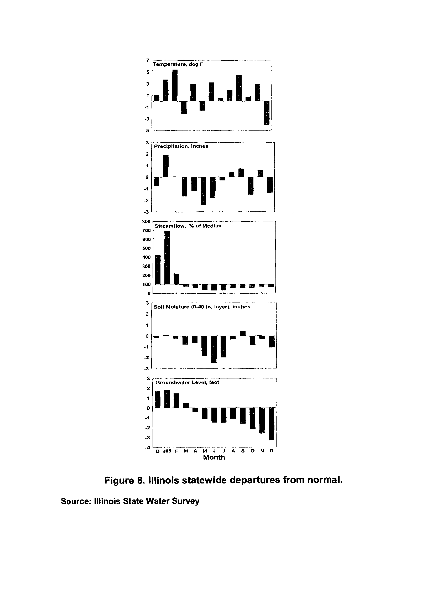
assessment of drought conditions in Illinois on January 6, 2006 (Exhibit 4), concluding
that from March-December, 2005, central Illinois had one of its driest periods on record
(third driest since 1895) and that surface lake levels were not replenished during 2005 .
The ISWS also reported in that assessment that soil moisture in most of Sangamon
County was only 25% of normal soil moisture based upon the 1985-1995 mean .
1
n
Additionally, stream -flow in the Springfield area comprising the Lake Springfield
watershed was in the below-normal range at the 10' percentile
. The ISWS concludes
that the amount of "precipitation in early spring will likely be key in drought recovery or,
on the other hand, in the advancement of drought conditions and water supply concerns ."
In view of current conditions and the current estimated schedule for completion of Hunter
Lake, the City of Springfield has decided to reapply with the Corps of Engineers for the
permit to construct the dam on the Sangamon River that is called for in the City's
emergency water supply plan.
As in prior instances, the Illinois Environmental
Protection Agency (IEPA) must certify under Section 401 of the Federal Water Pollution
Control Act (FWPCA) that the project will result in discharges that comply with
applicable water quality standards under Title III of the Act . For IEPA to certify this
consequence to the Corps of Engineers, the City again requests that the Board grant a
variance from the dissolved oxygen water quality standard as it relates to the Sangamon
River
. The purpose of this Petition is to seek the issuance of a new variance for a five
year period with the same terms and conditions as set forth in the order of the Board
granting variance in PCB 00-179 .
8 .
Petitioner hereby requests the incorporation of the record, opinion and order of
the prior variance proceedings, City of Springfield v
. IEPA, PCB 88-113, City of
Springfield v . IEPA,
PCB 93-135, and City of Springfield v . IEPA, PCB 00-179, into this
petition for a new variance comparable to those in the prior proceedings . Petitioner
represents that the exhibits and testimony of the witnesses presented by Petitioner in PCB
88-113 continue to be true and correct, and as updated in PCB 93-135 and PCB 00-179,
except as hereinafter noted
. A separate written request for such incorporation will be
11
made by the Petitioner as required by 35 111
. Adm
. Code 101
.106 along with four copies
of the record of each of those proceedings
.
THE DISSOLVED OXYGEN STANDARD
9.
If the proposed temporary dams on the Sangamon River are constructed, the
Petitioner proposes a downstream release rate of 41 CFS which ranges from 31 to 100
percent of the projected available stream flow in the Sangamon River during an 18 month
drought event . The discharge rate was derived in accordance with the following
methodology by consulting engineers retained by the City .
a.
The United States Geological Survey flow data from the Riverton, Illinois,
gauge site (river mile 82
.93) during the 1953-1955 drought were adjusted and used to
predict Sangamon River discharge for an eighteen-month, 100-year drought event in
1995 . The adjustment considered several factors
. First, the Illinois State Water Survey
estimated that the ratio for the Sangamon River discharge at Riverton during the 1953-
1955 drought (Exhibit 3 to the 1988 Petition) to a projected 100-year frequency drought
was 0.7
. Second, a reduction of the contributing drainage area over time to the Riverton
gauge was calculated based on those reservoirs built after the 1953-1955 drought
. Total
drainage area was reduced from 1443
.1 square miles to 1222
.3 square miles, owing to the
construction of Lake Taylorville and Lake Sangchris .
Therefore, only the watershed
areas downstream from dams forming Lake Decatur, Lake Taylorville, and Lake
Sangchris were considered to contribute runoff during low flow conditions (0
.846996
adjustment factor).
Third, the difference between 1953-1955 and future wastewater
discharges to the drainage area (13
.75 MGD) was added to the 1953-1955 data to
compensate for projected increased wastewater discharges (Crawford, Murphy and Tilly,
19
inc.,
City of Springfield, Illinois Technical Report on Emergency Water Supply Plan
(Engineering Report) (1983)) . (Record, 88-113, Tr
. 145-150.)
b.
Projected unrestricted flow data without the project indicated the average
discharge for the evaluation period was 83 CFS (Exhibit 4 to the 1988 Petition) .
Incorporation of a proposed downstream release rate of 41 CFS decreased the average
river discharge for the period of 59 CFS .
Based on projected river discharge,
approximately 71 percent of the unrestricted river discharge would be released
downstream of the proposed diversion facility . The proposed downstream release rate
ranged from 31 to 100 percent of the available, projected stream flow (Exhibit 5 to the
1988 Petition) .
c.
The final engineering design of the diversion structure will include a lower
conduit and valve configuration
. This will be of sufficient capacity to maintain a
constant downstream release rate of 41 CFS, whenever available in the river . Also, a
crest weir and riprap spillway will be constructed to permit higher river discharges to be
passed at or near river elevation 525 .0 feet M.S .L. Adequate river discharge gauging
means will be provided at the site
. Other dam design parameters will comply with
Illinois Department of Transportation (now Illinois Department of Natural Resources)
standards and regulations
. (Record, 88-113, Tr
. 152-160, 183-185 .)
d.
The operation of the lower and crest discharge structures will be
coordinated based on rate of flow and pool elevation at the diversion structure . It is
estimated that the storage volume of the upstream pool behind the diversion structure at
elevation 525
.0 feet M
.S
.L. is approximately 680 million gallons
. (Record, 88-113, Tr .
159-160
.) The length of time estimated to reach and maintain a full pool elevation at the
13
diversion structure depends directly on available river flow
. From data during the 1953-
1955 drought, the prolonged duration of low
river flow would suggest that maintaining a
full pool elevation would not be characteristic or possible at the diversion structure
.
However, recorded infrequent, maximum river discharges (up to 1700 CFS) would
theoretically provide sufficient water volume to fill the full pool elevation in less than one
day. (See also Record, 88-113, Tr . 159-161 .)
10.
Petitioner has likewise had its consulting engineers conduct a dissolved oxygen
(DO) analysis (Exhibit 6 to the 1988 Petition) .
DO levels in the Sangamon River
downstream of the proposed temporary dam were evaluated using Streator-Phelps
analyses with and without the presence of
the temporary dam under low-flow conditions
.
The analyses showed virtually no difference in the DO patterns downstream
of
the dam
given the two scenarios. The analyses did illustrate an increase in DO downstream
of the
channel dam due to the presence of
the proposed cascade aerator on the downstream side
of the temporary dam
. Further, downstream DO concentrations were demonstrated to be
enhanced over a broad range of impoundment influent DO concentrations at the diversion
facility spillway
. (Record, 88-113, Tr. 230-237.)
a.
Aeration of the Sangamon River impoundment by supplemental means
was also evaluated
. It was determined that incrementally raising the DO level from 2
.9
mg/l to 6
.5 mg/I would cost $372,000 to $661,800 (1988 dollars) in nitial capital costs
.
However, it was concluded further that it is very difficult to determine what will happen
to the water quality within the impoundment area with or without artificial aeration
.
Moreover, installation of the temporary equipment would require a lead time of four to
six months before it would be delivered to the project site
.
Based on these
14
considerations, supplemental aeration was not considered to be feasible
. (Record, 88-
113, Tr. 216-224)
. The Illinois Environmental Protection Agency has concurred with the
conclusions (Exhibit 7 to the 1988 Petition
.)
b.
Diel monitoring
of
DO in the pool upstream
of the existing channel dam
on the South Fork of
the Sangamon River in September, 1985 (Exhibit 8 to the 1988
Petition) provided empirical data from conditions that might be expected to occur with
the proposed diversion facility
. These data suggest that acceptable DO concentrations
may be available in the pool on the Sangamon and South Fork under the emergency
water supply plan
. (Record, 88-113, Tr
. 249-252 .)
11 .
Continuous compliance at all times with 35 Ill
. Adm. Code 302
.206 by Petitioner
would impose a substantial, arbitrary and unreasonable hardship on the Petitioner in that
the standard is not potentially capable
of
being achieved under all circumstances during
the life of
the actual project for which the variance is requested because
of natural factors
beyond the control of the Petitioner and because the standard sought to be achieved may
potentially not exist in the Sangamon River under drought events even without the
implementation of the river diversion project
.
a.
Without the Illinois Environmental Protection Agency being able to apply
a different standard to DO, the Agency would be legally unable to certify under Section
401 of the FWPCA to the Corps of Engineers for the requisite permit for the project to be
issued to the Petitioner
. No suitable comparable alternative exists in the short-term to
serve as an adequate supplemental water supply during drought events
. The Petitioner's
consulting engineers in 1983 evaluated alternative emergency water supply sources
including 1) well field development along the Sangamon River Valley, and 2) pumping
15
from the Buckhart, Sidener, Broughton and Clear Lake sand and gravel pits . The
potential of obtaining water from the Sangamon River gravel aquifers was approximately
1 MGD per three miles of river valley during drought periods
. Development would
require detailed test drilling and test pumping, plus an extensive piping and pumping
system to bring that water to Lake Springfield
. The potential return was not sufficiently
high to warrant this alternative nor could the system be implemented in time to serve as
an emergency supply .
The Sidener and Broughton pits were estimated to contain approximately 775
million gallons of water in 1988 which could be pumped with an additional l MGD being
drawn from the surrounding formations during pumping . At the same time, an additional
900 million gallons was estimated to be available from the Buckhart pits . A 1998 study
by Crawford, Murphy, Tilly in connection with the Hunter Lake project updated the
estimated volumes at these locations to be 2,121 million gallons and 2,278 million
gallons, respectively
.
However, the owner of the Bucldrart site was not interested in
making the water available on a long-term basis, and other site owners had mixed
interest
. These sources are not sufficient to be the sole source of an emergency supply
and would also require extensive pumping facilities for implementation
.
Water from
Clear Lake could he pumped to augment Sangamon River flow
; however, given the
proximity of Clear Lake to the Village of Riverton's water supply wells, this was not
considered to be a viable alternative
. (Record, 88-113, Tr. 162-169 .)
b.
To minimize the need for diverting water, the emergency water supply
plan includes a variety of administrative and procedural measures aimed at conserving
water in Lake Springfield
. The element of drought management is keyed to specific lake
16
levels and becomes more stringent as the
pool level drops. The trigger for
implementation of the Sangamon River portion of the emergency plan is a level of 557 on
June 30 at which tine administrative measures would pursue a specified schedule, as
shown in Exhibit 1
. However, in June of 1988, the City initiated voluntary conservation
while the lake level was not yet at 558
. The purpose of the mandatory measures is to
avoid the Petitioner's water users from exacerbating the declining lake level and creating
a self-imposed hardship
. The Petitioner would be committed to prudently managing its
existing water supply before resorting to pumpage through the project
. However, the
duration of the drought event cannot be forecast, and reliance solely upon water use
conservation may not be sufficient to maintain an acceptable diminished lake level
throughout the entire drought event
. Water saver kits and public information
dissemination would cost the Petitioner $240,000 . (Record, 88-113, Tr . 85-100.)
c.
During 1988, Petitioner instituted a program to provide free water saver
kits to retail water system customers
. The program, which is completely voluntary,
makes available customized kits of water saving devices to customers who request them .
The kits include low-flow shower heads, toilet dams, low
flow kitchen and bathroom
faucet aerators, toilet leak detection tablets, toilet tank
flow diverters and installation
instructions
. The number and types of devices provided in a kit are based specifically on
the requesting customer's needs .
The availability of these devices is advertised
periodically through billing inserts
. Through August, 2005, a total of 6,098 kits have
been distributed, almost entirely to residential customers . This number represents 14 .1%
of the system's 49,650 total water customers
. Totals for individual devices distributed
are as follows :
17
Low-flow Showerheads 9,264
Toilet Dams
10,450
Low-flow Bathroom Aerators
10,667
Low-flow Kitchen Aerators
8,792
Toilet tank Flow Diverters
3,938
Petitioner plans to keep this program active for as long as sufficient customer interest
exists
. This program was briefly discussed in PCB 88-113 (Tr . 361-367 .)
d.
Water conservation measures are included as a part of all the feasible
alternatives evaluated for water supply augmentation for the Hunter Lake Draft
Environmental Impact Statement (DESI) . Petitioner has implemented the two most
important conservation measures identified in the suite of conservation options evaluated
which measures ultimately reduce demand by 1 .3 to 1
.9 million gallons per day. The
most potentially significant conservation measure implementation was the voluntary
home plumbing retrofit program discussed above
. The second measure implemented in
1990 was revision of the City's plumbing code to require low-flush toilets and low-flow
showerheads and faucets for all new or replacement construction .
e
The ability to augment the Lake Springfield water supply could be a
critical factor in outlasting the drought event and maintaining electric and water utility
operations . While it may be possible to discontinue electric generation, this assumes that
the drought event has not impacted electric generating capabilities of other electric
utilities from whom the City normally would be able to purchase power to replace the
City's inability to generate electricity . (Record, 88-113, Tr . 326-348
.) The City is a
transmission owning member of the Midwest Independent System Operation (MISO)
which is comprised of member utilities from Ohio to Minnesota and Missouri
. On May
1, the MISO began operating Energy Markets approved by the Federal Energy
1R
Regulatory Commission (FERC) consisting of a Day Ahead Market and a Real Time
Market
. Virtually all the City's electric sales both for retail and wholesale transactions
now flow through and are subject to the prevailing market prices experienced by these
Markets. The City can currently produce electricity from its units on Lake Springfield
for a cost of $24
.65 MWH based upon the City's operating results from its most recent
fiscal year. This past summer poses in the MISO Energy Market ranged from $40 MWH
to $80 MWH from off peals to on peak hours in the Day Ahead Market
. Replacement
power costs would be considerably higher
. These increased costs would be passed
directly through to the City's customers
. Replacement power costs would be an
additional hardship experienced by the City and its electric customers . The water plant
would experience various pumping and treatment difficulties at lake level 551 MSL .
(Record 88-113, Tr. 194-200.)
Additionally, there would be no means by which the City
could "buy" water elsewhere. Should the City not be granted the variance request, the
City would be faced only with conservation measures as a hedge against the end of the
drought event
. Severe public health and welfare, fire protection, and economic
consequences could occur not only for the City but for approximately 80 percent of the
population of Sangamon County
. The prospective hardship that could occur without the
variance being granted is not justifiable . (Record, 88-113, Tr. 348-359 .)
f.
It is difficult to quantify precisely the economic effect of these
consequences
. Public health would be impacted to the extent that the City's ability to
provide sufficient quantities of potable water at sufficient water pressure would be
impaired
. Public welfare would be impacted with a greater degree of severity as water
use was curtailed and approached a level at which water rationing could be compelled .
1
o
Hospital aid nursing homes are among the largest users of water
. The ability to provide
adequate fire protection is to some extent capable of some quantif cation . The equalized
assessed valuation of real property in the City corporate limits on February 28, 2005, was
$1,748,394,988
.00
. This does not include the value of personal property protected, nor
does it include the value of property in other jurisdictions that rely on the City's water
system for fire fighting capabilities
.
It can be assumed that certain activities will be
affected by the fact that water use would be curtailed or eliminated resulting in a decrease
of or cessation of economic activities because of unavailable water . One study has been
conducted on the impact of a drought-caused mandatory water conservation program,
U .S
. Army Corps of Engineers, Prototypal Application of a Drought Management
Optimization Procedure to an Urban Supply System, Contract Report 83-C-4 (December,
1983)
. Nine Springfield industries were studied for a determination of monetary losses
resulting from a cutback in water delivery
. While the report indicated that such losses are
the most difficult to estimate, it focused primarily upon an economic loss to the area
.
Lost weekly payroll from six nonlocally owned companies due to a 50% reduction in
water supply would be $292,800 and $458,700 at a 100% water reduction, Id . at p. 56 .
Annual payroll for production workers in locally owned companies was $789,000 while
lost profits and fixed costs were estimated at a 100% reduction in water supply service to
be $87,000 . Id
. at pp. 57-58
. Two of the nine companies would experience a 100%
production cut back at a 50% decrease in water supply delivery, and at a 75% decrease an
additional four companies would have a 100% production cut back . (Record, 88-113, Tr .
357-361, 367-371 .)
20
The costs of the project would appear to be justifiable when measured against the
potential losses, socially and economically, that would be incurred without the project
.
Water quality monitoring would cost about $2500 per month
. The project would cost
less than $1 million to implement
. Operating costs would not be significant . The
potential impact of the project on the Sangamon River fishery would be estimated at
$65,000
. However, the impact on the Lake Springfield fishery without the project would
be at least that amount and probably substantially greater
. The benefits that the City
would obtain must be measured in the potential hardships that would be averted . The
project costs are insubstantial when weighed against the potential hardships
. (See
generally Record, 88-113, Tr . 106-109 .)
g.
The current standard for dissolved oxygen (35 IIl . Adm . Code 302 .206) is
unreasonable and unrealistic with regard to the proposed project . One study based upon
data from 38 streams in Ohio suggested that "DO levels may be expected to drop below 5
mg/l minimum for at least a short period of time for essentially all types of streams
regardless of the input from pollution sources
. In addition, all but the highest quality
water can be expected to approach and periodically drop below 4 mg/l
." Illinois
Pollution Control Board, PCB No
. R83-20, Record, Volume 1, p . 20 (1983) . The
American Fisheries Society (AFS) critique of U
.S. EPA's "Quality Criteria for Water"
suggested that the existing DO standard did not account for "specific regional variations
in chemical/physical regions or existing natural oxygen levels in aquatic ecosystems
which are subject to seasonable and biological variability ." Thurston et al.,
a Review of
the EPA Red Book :
Quality Criteria for Water, American Fisheries Society Water
Section (1979), at 169
. The findings of the AFS were that
". . . it is essential that
7i
consideration of natural regimes of dissolved oxygen be included in criteria application to
specific water bodies (and) . . . that flexibility inherent in the useful concept of `levels of
protection' is encouraged and endorsed
."
PCB No
. R83-20, Volume 1, p
. 21 . A
comparison of dissolved oxygen computer modeling results provided by the Illinois
Natural History Survey (INHS) (Exhibit 10 to the 1988 Petition) and actual river
discharge during the 1953-1955 drought (Exhibit 11 to the 1988 Petition) was made to
estimate DO concentrations in the river during drought conditions
. The results of that
comparison indicated that natural stream flow during a severe drought event may be
sufficiently low to cause prolonged periods of non-compliance with the applicable DO
standard to occur in the natural environment of the river
. Historical drought condition
flow data for the Sangamon River at Riverton would suggest that actual river discharge at
the proposed project site may likely be materially less than the minimum river discharge
predicted by the INHS model as being necessary to maintain tolerable DO concentration
minima
. Such empirical data would indicate strongly that critical biological thresholds
may not be maintained due to natural causes alone .
Moreover, this consideration was
recognized by the American Fisheries Society which stated that "
. . .
it is highly
unrealistic to prescribe rigid oxygen criteria for water that may be naturally low in
oxygen at some time of the year and may not meet the criteria for natural reasons
."
(Thurston et al ., at p . 171) (Record, 88-113, Tr . 68-77 .)
h.
The Petitioner does not believe the activity for which the variance is
requested would have any demonstrable contributing adverse environmental impact and
may, in fact, alleviate some environmental stress that would naturally occur during a
22
drought event
. Petitioner's environmental assessment of the proposed project was
attached as Exhibit 12 to the 1988 Petition
. (See also Record, 88-113, Tr . 270-300) .
While there is a certain inability to forecast DO concentrations upstream
of the proposed diversion structure, it is unlikely that DO concentrations will be
problematic in the pool upstream of the temporary impoundment . The City's consulting
engineers have concluded that prior use of channel dams on the Sangamon River and its
South Fork are similar to the proposed project which would only be on a temporary basis .
Specific conclusions were that :
"These structures have had little or no noticeable impact upon the water
quality of the streams during normal flow. However, during low flows
similar to which it is anticipated the emergency supply diversion
structure would be built, these structures, no doubt, enhance the aquatic
environment of the river, by providing impoundments and aerated
discharges ."
(Exhibit 13 to the 1988 Petition
.) Empirical field data recorded from the Petitioner's
existing movable channel dam on the South Fork indicated that DO concentrations
existed in the impounded area substantially in excess of existing criteria (Exhibit 8 to the
1988 Petition
.) (See also Record, 88-113, Tr . 249-252 .)
1.
A variance from the DO standard will not have an appreciable impact
upon the fishery and invertebrate populations that would not already exist from the
drought event during which the project would be implemented . The population density
of fishes may be significantly reduced by drought conditions (Dowling and Wiley, The
Effect of Dissolved Oxygen, Temperature and Low Stream Flow on Fishes
: A Literature
Review, Illinois Natural History Survey Aquatic Biology Section (1985))
. Further, when
exposed to low dissolved oxygen levels, many fish species migrate to tolerable regions,
dramatically altering local fish community structure . Among the Sangamon River fishes,
1)z
largemouth bass and white crappie would tend to avoid areas of low dissolved oxygen .
In contrast, red shiners, sunfishes, and course fish would he expected to be tolerant of
low dissolved oxygen . Based on an actual period of record drought conditions, it is
reasonable to assume that the Sangamon River fishery at the project site would be
materially absent or at least substantially different from the normal character of the area,
prior to commencement of Petitioner's proposed activities . As a result, it is difficult to
predict what fishes, if any, may serve to be protected by the application of standard
dissolved oxygen criteria in an extraordinary, yet natural scenario . (Record, 88-113, Tr .
270-286
.) Moreover, it is contended that such a persistent coarse fishery would have
negligible value
. Existing Illinois EPA fish flesh contaminant data relevant to this region
of the river indicated the presence of toxic biocides at concentrations that could lead to a
ban on commercial fishing and be cause to prompt an advisory against fish consumption .
k.
In addition to the evaluation of potential project impacts on the Sangamon
River fishery, equal consideration must be made for the significant sport fishery in Lake
Springfield, which would be a benefactor of the proposed project . For the past twenty-
one years, the petitioner has cooperated with the Illinois Department of Natural
Resources via a Cooperative Fishery Management Agreement to stock Lake Springfield
with various sport fishes (i .e., tiger muskie, walleye, largemouth bass) and develop a
rearing pond for sport fish try . Inasmuch as lake fishes have a lesser ability to avoid
poor water quality regimes under declining reservoir conditions, the effect of our
proposed diversion to maintain an acceptable reservoir pool level would help assure the
survival of sensitive game fish in Lake Springfield as well as sustain the fine results of
24
cooperative efforts with the Illinois Department of Natural Resources . (Record, 88-113,
Tr. 292-297
.)
12 .
This variance can be granted by the Board consistent with all federal regulations
such that the Illinois Environmental Protection Agency could issue a compliance
certification under Section 401 of the FWPCA regarding Title III standards
. The
Petitioner has exercised all available methods to forecast the effects of our proposed
project, including incorporation of empirical data to the greatest possible extent
.
Application of the general use water quality standard for DO for the proposed project
would not be reasonable
. Available data indicates that it is unlikely that such standards
could be achieved during severe drought events in the absence of the City's proposed
diversion plan
. In fact, given the pooling and aeration effects of the proposed diversion
structures, it is probable that the diversion configuration may mitigate the otherwise
deleterious effects of the low-flow drought conditions, at least on a localized level
.
Furthermore, the temporary and improbable nature of the emergency plan would not
compromise efforts to achieve long-term compliance with acceptable water quality
standards in the Sangamon River
. Based on these considerations, the project is a prudent
strategy to ensure the provision of essential service while causing, on balance,
environmentally neutral consequences.
13
. A fishery survey of the Sangamon River would be performed immediately before
construction of the temporary diversion structures to provide a baseline against which
further damages, if any, could be measured. A water quality sampling and analysis
program will be conducted upstream and downstream of the diversion structure for the
duration of the project
.
25
UPDATING THE RECORDS
OF PCB 88-113, PCB 93-135,
and PCB 00-179
14 .
The 1988 variance proceeding included testimony and exhibits regarding steps
the City has taken to augment its water supply through the pumping of water from other
sources (R
. at 25-31) .
Shown on Exhibit 5 to this Petition are tables showing water
pumped from the South Fork Pump Station from 1976 through December, 2005 and
from the clarification pond from 1979 through December, 2005
. During that period
47,518 millions of gallons were pumped from the South Fork
. Of this total, 13,981
million gallons were pumped during the drought event of 1987-89 (30 .8%) . Similarly,
during the same drought event, 938 million gallons were recirculated from the
clarification pond
. From 1995 to 2000 the City was unable to recirculate water from the
clarification because of NPDES permit limitations regarding boron concentrations . In
connection with the Agency's support for the City's 2000 variance petition, a solution to
the moratorium was developed and implemented
. Since that time, the City has been able
to recirculate 1,387 million gallons from the clarification pond to the Lake
. The
resolution of this moratorium is discussed in paragraphs 40-45 below
.
15 .
In 1991, Planning and Management Consultants, Ltd ., completed a new water
demand forecast for Petitioner
. This work was basically an extension of the modeling
used in the 1986 report which was discussed in the 1988 proceeding (Record, 88-113, Tr
.
41-49 .)
However, an updated version of IWR-MAIN was utilized and updated
information was input to the various components of the model
. Exhibit 6 is a
representation of tables summarizing the water demand forecasts of the 1986 and 1991
studies and actual water usage data available to Petitioner for comparison to both the
1986 and 1991 studies through October, 2005
. Base demand forecasts were updated by
26
the Petitioner in 2005, and the base forecast for the year 2005 was revised to 20
.8 MGD
with 24.5
MGD for the extreme hot and dry/high growth scenario
.
16.
Petitioner also provided testimony and exhibits regarding its twenty largest water
customers (Record, 88-113, Tr
. 310-317
.) Exhibit 7 is a table setting forth the largest 20
water users on Petitioner's system.
Petitioner has a comprehensive computer report
which lists all water customers in alphabetic order by account name and summarizes
annual usage for each account
. On Exhibit 7, a customer is defined as a set of accounts
listed in the billing system by the same account name and located in the same geographic
vicinity
. This definition is required because most of the large customers have multiple
water accounts
. If a customer displayed multiple accounts, the usages of those accounts
were aggregated for this exhibit
. Exhibit 8 is another table depicting the twenty largest
water users with a comparison of water consumption for Fiscal Year 1999 and Fiscal
Year 2005 .
LONG TERM WATER SUPPLY
17 .
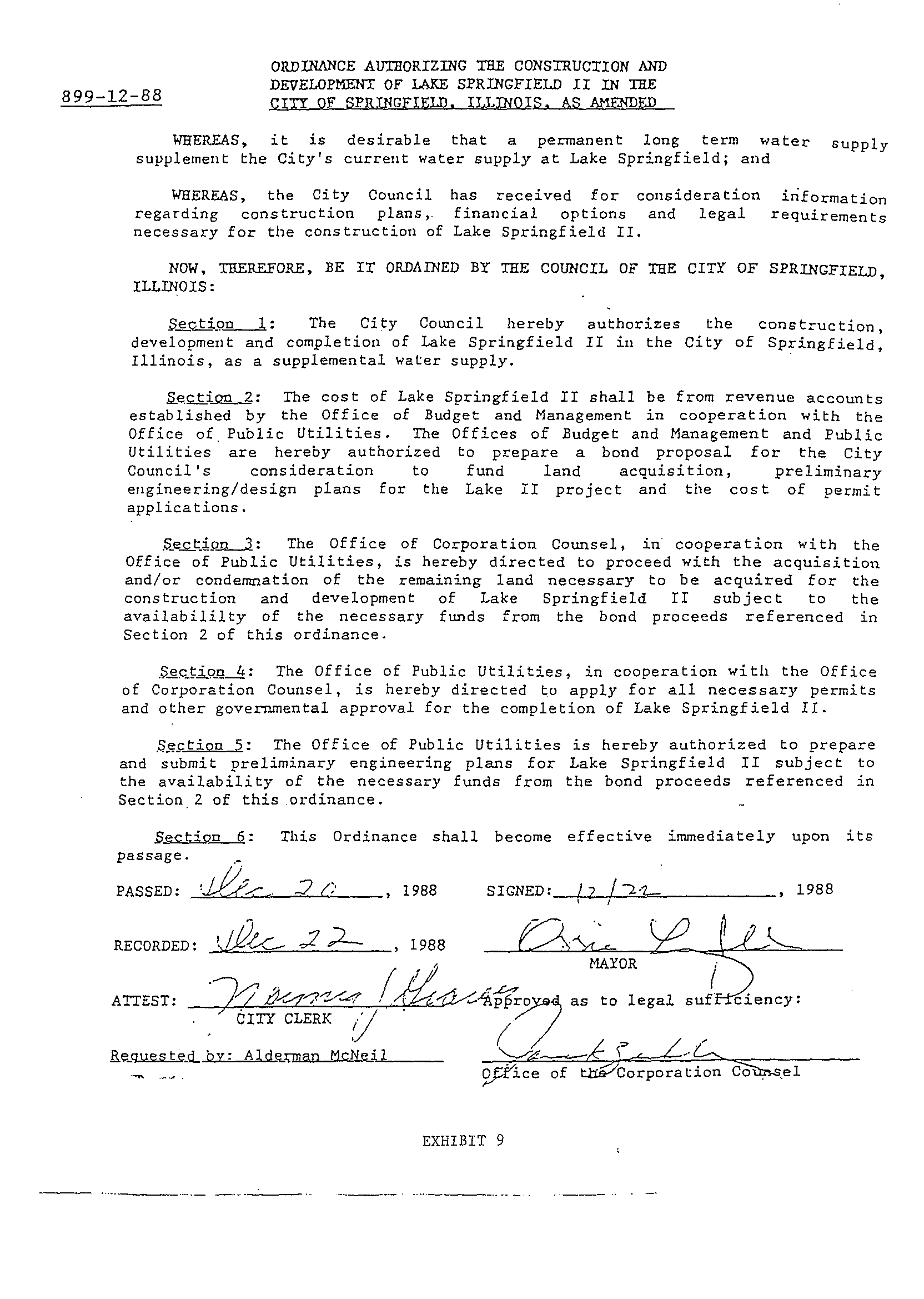
The Board's order in PCB 88-113 conditioned the granting of the requested
variance upon Petitioner undertaking a schedule for an alternative plan to eliminate the
need for implementing the particular project for which the variance was granted
.
Petitioner embarked on pursuing the alternative of a second lake
.
On December 20,
1988, the Council of the City of Springfield adopted Ordinance No
. 899-12-88, entitled
"Ordinance Authorizing the Construction and Development of Lake Springfield II in the
City of Springfield, Illinois, as amended (Exhibit 9)
.
The Council then adopted
Ordinance No
. 54-1-89 on January 17, 1989, naming the proposed second lake as John
H
. Hunter Lake, hereinafter referred to as Hunter Lake
. This was followed by Ordinance
27
No
. 97-2-89, adopted on February 7, 1989, prescribing the land that would be owned by
the City around Hunter Lake would be dedicated as a conservation area and any
development was limited to structures compatible with the conservation of wildlife
(Exhibit 10)
. On July 26, 1989, Petitioner mailed its joint application, dated July 27,
1989, for a permit pursuant to Section 404 of the Clean Water Act with the three
appropriate reviewing agencies, i .e
. the United States Army Corps of Engineers, the
Illinois Environmental Protection Agency, and the Illinois Department of Transportation
.
Soon thereafter, on August 3, 1989, Petitioner issued $17,985,000 in water revenue
bonds to fund completion of land acquisition for the Hunter Lake Project, preliminary
engineering work for the project, and development of the environmental impact
statement that appeared would he necessary
.
18.
On September 14, 1989, the United States Army Corps of Engineers determined
that "the project will have significant (both positive and negative) impacts in the project
area and warrants preparation of an EIS (Environmental Impact Statement) to meet
National Environmental Policy Act requirements during processing of the permit
application
." Notice of this determination appeared in 54
Federal Register 45780 on
October 31, 1989
.
A public hearing on the scope of the Draft EIS was held in
Springfield, Illinois, in December, 1989
.
19 .
In order to develop the Draft EIS for submission to the Corps of Engineers,
certain preliminary engineering work needed to be completed
. In September of 1989,
Petitioner entered into contracts for engineering services with two firms located in
Springfield, Illinois, i.e
. Crawford, Murphy and Tilly, Inc . (CM&T) and Hanson
Engineering, Inc
. (HEI)
. CM&T was retained to update mapping, conduct water quality
28
studies and hydrologic budgeting, and infrastructure planning
. HEI was employed to
perform flood modeling work with and without the proposed project both upstream and
downstream of the proposed dam
. Prior to beginning the modeling work, HEI completed
the conceptual design
of the dam, including spillway elevation and fixed crest
determination .
20.
Triggering the EIS requirement of
the National Environmental Policy Act also
meant that before a 404 permit could be issued by the Corps
of Engineers, the project
also had to comply with Section 106
of the National Historic Preservation Act . This
requirement consists
of
a determination of whether there are any cultural, historical or
archaeological sites in the project area that may be eligible for the National Register of
Historic Places. This is a three-phase process
. Phase I is development of an inventory of
sites
. Phase Il involves the further investigation of potentially eligible sites . Phase III is
the mitigation of those sites that are determined to be eligible for the National Register
and that would be adversely impacted by the project
. The Petitioner contracted with the
Illinois State Museum to conduct Phase I in March of 1990 . The Museum completed its
report in May, 1992, which included a recommendation of Phase II activities . The Phase
I report has been reviewed by the Corps of Engineers and the Illinois Historic
Preservation Agency (IHPA)
. Petitioner does not anticipate commencing Phase II of this
work until after a 404 permit is issued by the Corps of Engineers
. Petitioner entered into
a Memorandum of Agreement with the Corps of Engineers, the IHPA and the Council on
Historic Preservation governing its future efforts in the project area that would represent
compliance with Section 106 in September, 1999 .
29
21 . When the City Council decided to go forward with the project now known as
hunter Lake in December, 1988, the regulatory framework governing such an endeavor
had dramatically changed since the lake was originally conceptualized in the 1960's
.
Virtually none of the information was compiled at that time to develop the reports that
are now needed to accompany the review of the joint permit application
. Little practical
engineering of the project had actually been performed
. Much of the engineering work
that was completed in the 1960's and 1970's did not meet the degree of regulatory
compliance of the late l 980's and 1990's
. Petitioner was basically required to initiate all
new study efforts in this regard
. The drafting of an EIS requires an examination and
evaluation of a series of cultural, social, economic, and ecological subjects
. The
Petitioner entered into a series of contracts to develop the information necessary for the
EIS.
22. In March, 1990, Petitioner entered into a contract with the Illinois Natural
History Survey to conduct research and develop conclusions regarding many of the
ecological components to he addressed by the EIS process
.
These included general
biological investigations and inventory for the project area (fishes, mammals, birds,
reptiles, and amphibians), issues concerning threatened and endangered species and
wetlands, vegetation and soil investigations and inventory, soil erosion and siltation
issues, prime farmland issues, and habitat evaluations
. By March 1993, the National
History Survey had completed all aspects of its work with the exception of final
delineation of jurisdictional wetlands which was completed in the summer of 1993
.
23 .
A contract was entered into in April, 1990, with a team from Sangamon State
University (now the University of Illinois at Springfield) to explore and develop issues
10
and impacts from a socio-economic standpoint for the p1S . Their task covered
population matters and characteristics of the project area, personal income, employment
patterns and opportunities, housing and capital assets, farm and business impacts, public
facilities and services, with analysis of impacts on taxing districts and revenue .streams,
and community or cultural issues
. The reports were finalized and completed by January
of 1993 .
24. To complete other aspects of the socio-economic parameters of the Hunter Lake
project, Petitioner retained the Springfield- Sangamon County Regional Planning
Commission to inventory and analyze land use patterns, demographic information,
public facilities and services, and recreation issues and opportunities . This project was
completed with the submission of a final report January, 1992 .
25.
The Illinois State Water Survey was hired in June, 1990, by Petitioner to evaluate
water supply availability during drought events for Petitioner . This updated a 1986 study
the Survey conducted previously for Petitioner. The Survey updated Lake Springfield
yield based upon the dredging project that had been conducted by Petitioner at Lake
Springfield and analyzed the yield available with Hunter Lake . This task was completed
in August, 1991 .
26
. The Petitioner also contracted with Planning and Management Consultants, Ltd
.
of Carbondale, Illinois, in November of 1989 to update the 1986 Water Demand Study
and to evaluate water conservation techniques including a cost and benefit analysis and
social acceptability of water conservation measures
. The Water Demand Study was
completed in July, 1991, and the water conservation tasks were finished in January,
1992.
31
27.
By November, 1992, Petitioner had completed reviewing reports that had been
submitted pursuant to the above contracts and had begun writing the Draft EIS (DEIS) .
Petitioner submitted DEIS to the Corps of Engineers on October 1, 1993
. Upon review
of the DEIS materials submitted, the Corps informed the Petitioner on August 1, 1994
that, among other issues, alternatives to Hunter Lake must be more fully evaluated at a
level of detail comparable to the Hunter Lake alternative
. The scope of additional work
required by the Corps to meet their requirements for publication of the DEIS was
substantial .
Many responses to the Corps' comments were provided in November, 1994
.
Upon extensive discussion with several consultants and the Corps, a revised scope of
services was proposed in May 1995 to address the major items remaining
. The reviewed
scope of work was accepted by the Corps in October 1995
.
28 .
A contract was executed with Crawford, Murphy and Tilly, Inc . in November,
1995, to develop surveys of downstream flooding affects for Hunter Lake, upstream
sewage treatment impacts, gravel pit source water evaluations, and pipeline pumping
systems for deliveries of source waters from the gravel pits, the three proposed
groundwater sources, and the Springfield Metro Sanitary District water for the closed
loop ash sluice option.
29.
A contract with Hanson Engineers was executed in November, 1995, to model
the wastewater and closed loop options for ash pond sluice water, and to perform
environmental reviews of the pipeline corridors for groundwater, gravel pit, and Lick
Creek reservoir options
. Hanson Engineers' work also included a wetlands evaluation
32
for Hunter Lake and an analysis of the option to raise the full pool level of Lake
Springfield .
30.
A contract with The Illinois State Water Survey (ISWS) was executed in April,
1996, to complete three work products for the Petitioner
. The ISWS would evaluate
groundwater availability in these localities : the Sangamon River Valley, the Illinois
River Valley, and the Havana Lowlands
. It would develop operating models for the
optimal transfer of water to Lake Springfield from the various sources . Finally it would
evaluate the water quality of the proposed reservoir sources and Lake Springfield under
drought conditions
.
31 . Upon completion of all study elements, final reports and a revised DEIS text was
transmitted to the Corps on May 8, 1998 .
The Corps compiled all of the available
information and published the DEIS for the Hunter Lake Project on April 9, 1999, The
45-day comment period was extended upon request of the U .S . Fish and Wildlife Service
and comments were received by the Corps through June 18, 1999 . Comments were
sorted and evaluated by the Corps, and a request was forwarded to the City on September
14, 1999 asking for the City to provide additional information and response to various
DEIS comments.
The City forwarded the majority of comment responses to the Corps on February
3, 2000 . Additional responses requiring joint action by the City and the Corps were
completed on August 29, 2000 . Publication of the final EIS occurred in November,
2000
. A public hearing on the final EIS was held by the Corps on February 26, 2001 .
32.
Between March and May 2001, additional wetlands information and responses to
FEIS public hearing comments were formulated
. The Corps began formulating its
33
Record of Decision, but its completion remained subject to IEPA issuing its Section 401
permit conditions
. In September 2001 IEPA specified additional elements needed with
regard to the sewage outfalls of Divernon, Pawnee and the Virden Sanitary District for
discharges in the Hunter Lake Watershed
.
33 .
From November 2001 to the present, studies and negotiations regarding options
for relocating effluent discharges or upgrading the sewage treatment facilities for the
three communities, as well as addressing flooding concerns of the Village of Pawnee,
were conducted
. Draft agreements were prepared for consideration in each community .
34 .
On August 27, 2003 an agreement was finalized between Divernon and Petitioner
with regard to relocating the effluent of their sewage lagoon outfall . Agreements with
Pawnee and the Virden Sanitary District remain outstanding
.
35 .
In October 2004 an additional study regarding the feasibility of pumping Virden,
Divernon and Pawnee wastewater to the Springfield Metro Sanitary District was
completed
. Negotiations continued with all three communities to the present .
36 .
In April 2005 Petitioner forwarded correspondence to the IEPA and to the Corps
of Engineers outlining updated water demand and yield information and requesting
renewed effort at issuing the Section 401 Water Quality Certification and the Record of
Decision, respectively.
37 .
On June 2, 2005 a meeting was held with the Corps
. Background information
was reviewed and new revised information needs were presented to the Petitioner by the
Corps for the Corps to complete it's Record of Decision
. Hanson Engineers was retained
on July 5, 2005 to provide requested updated summary information regarding project
34
alternatives and additional environmental impacts related to the proposed village sewer
projects .
38 .
Negotiations and exchanges of information regarding the sewer projects for the
three villages are ongoing .
39.
Petitioner had acquired 5,587 acres for the project prior to 1978 . The original
area of the project was 7,701 acres. Subsequent to the issuance of the above-referenced
water revenue bonds, Petitioner initiated acquisition of the remaining land required for
the project . Through March 31, 2000, Petitioner had acquired an additional 1541 acres
in 73 transactions.
No additional purchases have since been completed . The total
acreage acquired for the project is now 7,128, and the project area is now estimated to be
7,795 acres. The Petitioner continues to seek to acquire the remaining property
.
40.
In the Agency Recommendation filed in PCB 93-135, it requested that the
Board's grant of a variance require that the Petitioner continue to supplement Lake
Springfield with the recirculated clarification pond water . The Agency concluded that
this had "a lesser environmental impact of allowing the City to temporarily return this
clarification pond water into Lake Springfield during extreme drought events than in
damming the Sangamon River."
(Paragraph 6 of the Recommendation .) The
clarification pond water is more fully discussed in paragraph 2b above. The Agency was
of the opinion that by utilizing this water the City may lessen the need or duration of
damming the Sangamon River
. Prior to filing its 2000 petition, the City met with the
Agency on April 28, 2000, to develop an acceptable operating scenario by which this
clarification water could be returned to Lake Springfield during drought events while
35
meeting the general water quality standard for boron in Lake Springfield and resulting in
no adverse impacts on the finished drinking water of Springfield .
41 .
The modification the City proposed involved relocating the clarification pond
discharge to the Lake to the Dallman Plant Intake . This relocation would divert ash pond
effluent into the Dallman cooling water intake . This intake is for once-through, non-
contact cooling water. It discharges back to Lake Springfield through two different
outfalls .
The re-routing of clarification pond discharge to the Lake would involve
installation of approximately 2400 feet of 20 inch HDPE welded plastic pipe from the
existing discharge point in the Spaulding Dam along the lake bottom to a location
centered at the Dallman intake barrier net . The pipe would be weighted and anchored to
the lake bottom to prevent displacement . New pumps would also be installed at the ash
pond to overcome the head capacity created by the 2400 feet of discharge pipe .
The Agency agreed to allow this modification with additional sampling
requirements at Dallman discharge outfalls for the cooling water
. There was also to be a
self-imposed sampling limit for boron to ensure compliance with the Illinois General Use
Water Quality limit for boron.
42 . On May 3, 2000, the City submitted an Application for Permit/Construction
Approval to the Agency to modify its NPDES permit . Included with this application was
the proposed sampling program . This program committed to not exceed the General Use
Water Quality limit of 1 mg/I for boron . This would be done by weekly sampling, or
even more frequently as required to ensure compliance at the outfalls and the intake for
the Water Purification Plant . The City would meet the 1mg/I limit for boron at the
36
outfalls and a weekly average limit of 0.85
mg/l at the intake for the Water Purification
Plant.
If these limits were reached, pumping from the clarification pond would
discontinue.
43 .
On June 8, 2000, the City received the draft NPDES permit for the 30 day public
notice
. It provided for the construction and operation of the relocation of the clarification
pond discharge pipe, with the sampling precautions discussed above
. On June 12, 2000,
IDNR sent their response
. The City would not be required to obtain permits from them,
but needed to receive a 401 Certification or Site Specific Certification from the U .S.
Corps of Engineers and IEPA
. This certification was granted the end of August . The
City's modified NPDES permit became finalized on July 20, 2000
.
44.
Contracts were then sent out for materials and construction of the pipeline and
new pumps
. By March 2001, the pipeline had been constructed and the new pumps were
in place at the old discharge point
. Startup of the system began March 21, and went until
April 6, 2001 .
Operation procedures were developed and the system was placed in
service on July 18, 2001
. The pumps ran July 18-31, 2001, at an average flow of 5 .2
MOD. They operated through August at 7
.9 MOD . The discharge continued until
September 21, when boron concentrations in the lake required the pumps to be shut off
The average flow for September was 5 .4 MOD.
45.
Exhibit 5 includes results of the use of the new recirculation capacity . It was not
utilized again until July 26, 2002, when it operated July 26
- July 31, with an average
flow of 1
.8 MOD . The pumping continued through August at an average flow rate of 6 .3
MOD.
The system was then shut down after reaching permitted boron levels . The
pumps were able to be turned back on September 11, and were operated until October 25,
37
when boron levels caused the pumps to be shut off again . September's average flow was
4.0 MGD and October's was 4.8 MGD . The pumps were placed hack in service on
December 13, and run to January 8, 2003, before being required to be turned off after
reaching boron limits . The recirculation mode was not used again until August 2005
. It
was operated just three days a week from August 8 to September 16, when boron levels
were reached in the lake requiring the pumps to be turned off. August's average flow
was 3.4 MGD and September's was 2
.2 MGD .
46. The quality of the Sangamon River between Decatur and Riverton is generally
similar if not improved since the Petitioner's first Petition in this matter (PCB 88-113) .
IEPA's Illinois Water Quality Report for 1994-1995 (September, 1996) (IEPA/BOW/96-
060a) showed generally no trends up or down in the quality of seven parameters at
Riverton with the exception of a slight upward trend in Ph, an indication of a slight
increase in the buffering capacity of the stream . Comparison of biological and water
quality survey results of the Sangamon River as illustrated in a 2004 IEPA Facility
Related Stream Survey report show distinct improvements in the near-Decatur portions
of the Sangamon River . (See Exhibit 11) Advancements are attributed to the
improvements in wastewater treatment plant discharges and in the handling of combined-
sewer overflows . Dissolved oxygen was noted as not meeting the state general use
standard at one station in 1996, but DO met the standards at all locations during the 2003
survey. These data further support the Petitioner's proposition that the Sangamon River
water would be suitable for transfer to Lake Springfield as a supplemental source of
water. It is also still believed that the proposed emergency diversion would not affect the
38
long-term water quality of the river, and not affect the dissolved oxygen concentrations
beyond what might occur naturally without implementation of the project
.
47.
The variances previously granted to the Petitioner in PCB 88-113, PCB 93-135,
and PCB 00-179 were each for a term of five years
. Petitioner again seeks a variance for
a term of five years
. Petitioner does not anticipate that it will have secured a second
water supply during this five year period. Upon the Agency's issuance of the 401 water
quality certification for the Hunter Lake Project, the Corps of Engineers can proceed to
make its decision on the underlying permit application
. If the Corps does grant the
permit and the United States Environmental Protection Agency concurs (the Agency is
deemed to have veto power under Section 404 (c) of the Clean Water Act), Petitioner
will then proceed with detailed engineering of the project, development of plans and
specifications for construction contracts, bid contracts and conduct Phases II & III
historical and archaeological work . Petitioner must also issue bonds to finance this work
and the subsequent construction activities
. Petitioner estimates that it would take at least
two years to complete construction and fill the lake
. Since it will take over five years to
put the additional water supply in place, Petitioner believes that the variance should be
granted to continue the potential for the Sangamon River to serve as an emergency
supply of water in accordance with the plan discussed in PCB 88-113, PCB 93-135, and
PCB 00-179 should a drought event occur prior to completion of Hunter Lake
.
39
WHEREFORE, Petitioner requests that the Board grant it a variance from 35 111 .
Adm. Code 300.026 for the duration of any Corps of Engineers permit for a temporary
diversion of the Sangamon River during drought events for which the Illinois
Environmental Protection Agency is required to give certification under the FWPCA
.
Petitioner further waives a hearing on this petition in anticipation that the Illinois
Environmental Protection Agency will respond favorably to the variance request .
Alternatively, should said Agency oppose the variance request, Petitioner would request
that the Board schedule a hearing on this petition .
Respectfully submitted,
CITY OF SPRINGFIELD, ILLINOIS
a municipal corporation
By
/ 41+ ~ r-
Jenifer L . Johnson
Corporation Counsel
3rd Floor ; Municipal Center East
Springfield, Illinois 62701
Telephone
: 217-789-2393
William A . Murray
Office of Public Utilities
4"' Floor, Municipal Center East
Springfield, Illinois 62757
Telephone : 217-789-2116 extension 501
hmurray@cwlp .com
40
STATE OF ILLINOIS
)
AFFIDAVIT
COUNTY OF SANGAMON
After first being duly sworn and under oath, the undersigned, Thomas M . Skelly,
states as follows:
1 .
I am the Water Division Manager, Office of Public Utilities, City of
Springfield, Illinois, and I have served in such capacity since July, 1991
.
2.
In such capacity, I am responsible for all activities of the Water Division
relating to source of supply, water purification and distribution of potable water . I report
directly to the General Manager of the Office of Public Utilities
. I have primary
responsibility for implementation of the City's emergency water supply plan . I also am
the Project manager for Hunter Lake
.
3.
From November, 1984, until my appointment as Water Division manager,
I served as Supervisor of Water Resources and was responsible for development of
certain aspects of the city's emergency water supply plan . In such capacity, I
participated in the proceedings in PCB 88-113 .
4.
I have read the foregoing Petition for Variance and based upon my best
knowledge and belief, the allegations contained herein are true and accurate
.
5.
If I were called to testify to the sarne with regard to the Petition before a
hearing of the Illinois Pollution Control Board, my testimony would support the
allegations of said Petition.
Subscribed and sworn to before me this ( b _ day of
e,Gol,
r,~L,,
,
2006 .
)
IN otary Public
OFFIQIAL SEAL
RUTHANN SHEETS ':
NOTARY PUBLIC, STATE OF ILLINOIS
:' MY COMMISSION EXPIRES 8
.12 .2009 '1-
41
CITY OF SPRINGFIELD
DROUGHT MANAGEMENT SCHEDULE
EMERGENCY WATER SUPPLY PLAN
EXHIBIT 1
Below full pool at any time from
April to December 1
(1)
Pump from South Fork of Sangamon River when water
is available.
Below 6 inches below full pool at
(1)
Pump from South Fork when water is available .
any time from December 1 through
April 15
(2)
Recycle ash pond water to lake (if permitted)
.
Below average lake elevation in
April
(1)
Advise public that lake level is below average for this
time of year .
(2)
Prepare ordinance for mandatory water conservation measures .
(3)
Request retail and wholesale customers to conserve
water .
(4)
Enhance notice about the availability of water saver kits
for retail customers .
Below average lake elevation in
(1)
Advise public that lake level is abnormally low .
May
(2) Pass ordinance for mandatory water conservation
measures .
Elevation 558
In June
(3)
(1)
Notify wholesale customers of water use restrictions
passed by city and applicable to their customers .
Advise public that lake level is abnormally low and not
expected to recover to normal levels during summer .
(2)
Continue pumping water from the South Fork to lake .
(3)
Continue recycling ash pond water (if permitted) .
Elevation 557
On June 30
(4)
(1)
Enhance campaign of water conservation education.
Advise customers that lake has not recovered to normal
pool .
(2)
Continue pumping water from South Fork to lake .
(3)
Continue recycling ash pond water (if permitted) .
(4)
Request additional assistance from retail and wholesale
customers to conserve water.
(5)
Step up enforcement of water restrictions and customer
penalties concerning water use restrictions .
(6)
Begin construction of emergency pumping facilities
from Sangamon River
.
Elevation 556
(1)
Continue public information campaign
.
(2)
Initiate emergency pumping from Sangamon River upon
completion of emergency dams .
(3)
Prepare water rate surcharge ordinance .
EXHIBIT 1
Elevation 555
(1)
Request emergency conservation of water
.
(2)
Apply water rate surcharge .
Elevation 554
(1)
Expand distribution of water saver kits
.
(2)
Reduce system pressure .
Elevation 553
(1)
Begin audit of high water demand users
.
(2)
Prepare second water surcharge ordinance .
Elevation 552
(1)
Apply second water rate surcharge .
(2)
Intensify enforcement of water restrictions .
(3)
Prepare ordinance restricting all non-essential water
uses .
Elevation 551
(1)
Pass ordinance prohibiting all non-essential water uses
except for health necessities.
(2)
Implement further possible reduction in system
pressure.
Elevation 550
(1)
Intensify enforcement of prohibited uses.
(2)
Continue monitoring large users
.
(3)
Continue pumping water from all available sources .
Average lake level during each month based on an average
of average monthly levels each year from 1936-2005
.
Full pool elevation is 560
.00 feet above mean sea level .
Exhibit 2
Months
Average Surface
Elevation
January
557 .99
February
558 .08
March
558
.59
April
559 .16
May
559 .54
June
559 .66
July
559 .38
August
558 .94
September
558
.42
October
558 .06
November
557.88
December
557.91
CWLP
- Lake Elevations
Full
Pool-
1999-00
-2004-05
-2005-06
-2000-2001
-1988-1989
-Average
Exhibit 3A
CWLP
-
Lake Elevations
546
0
'~
h O h O A 0
^~
0 3 0
1
.
'1
`
~L l ~ '~
0 0 h N 0 O 5
~ ~
s
J~~
3J O
~
O\^
~
J\
~Q
O
PP
0
e
~
,
:
P
~~~
o,
o,~0e
~`a
c
~ QQ
c
~ QQ
cO
-Average
Full Pool
1999-00
-1976-77 -2005-06
-2000-2001'
.
1988-1989
1952-1953
- -
1953-1954
1954-1955
Exhibit 3B
Illinois Drought Update, January 6, 2006
DROUGHT RESPONSE TASK FORCE
Illinois State Water Survey, Department of Natural Resources
For more drought information please go to http://www.sws.uiuc.edu/
SUMMARY. Extreme to severe drought persists throughout most of northern Illinois and is
evident in record low precipitation since March 2005, low streamflow, low soil moisture, and
low groundwater levels
. Dry conditions extend into west central, west southwest, and east
southeast Illinois. Instead of recovery that normally is expected during fall and early winter,
the
drought has intensified
. Although the drought has caused adverse impacts, the impacts on water
supplies would have been much more severe if the same extreme drought had occurred in central
or southern Illinois, where there is an increased reliance on reservoirs and lakes for water
supplies
. Above normal amounts of precipitation are needed into spring to end the drought .
1. DROUGHT STATUS. According to the U .S
. Drought Monitor (Figure 1), most of northern
Illinois remains in a severe or extreme drought (categories 2 and 3 in their 4-category drought
classification)
. This week the area along Lake Michigan was reduced from an extreme (category
3) to severe (category 2) drought
. However, ISWS scientists did not concur with this change in
status, based on indicators that showed no improvement in that area . Much of central Illinois
remains in the categories of moderate drought or abnormally dry
. Only southern Illinois is
considered to be clear of drought . There is some concern with the recent intensification of
drought in Texas, Oklahoma, and Arkansas . Early in the last growing season, dryness in that area
joined with widespread dryness across Missouri and Illinois
. The Drought Monitor is updated
each Thursday morning at 8am EDT and can be accessed via the Internet at
http://www.drought.unl.edu/dm/monitor.html .
2. PRECIPITATION. Statewide precipitation between the last DRTF meeting on December 1
and January 5, 2006, has been 1 .72 inches, which is 1 .37 inches below normal . Conditions were
uniformly dry across the state with no area receiving close to normal precipitation
. Statewide
precipitation (Figure 2) since March 1, 2005, has been 25
.17 inches (10 .16 inches below normal
and 71 percent of normal). Precipitation deficits at individual sites can be even more severe
.
Since March 1, Moline received only 14 .77 inches (20 .47 inches below normal)
; Chicago, 18.34
inches (14 .87 inches below) ; Rockford,
19.62 inches (14 .54 inches below)
; and Quincy, 20 .25
inches (14 .83 inches below)
. The deficit has worsened since the last DRTF meeting by 1.34
inches
. At this time, no snow is reported on the ground in Illinois
. As a result, there is no
moisture storage available for release into the soil later on
.
3. LAST100
YEARS
.
Historic long-term precipitation deficits continue in the state, especially
in northern Illinois
. Statewide precipitation totals during the March - December period were the
3rd driest such period since 1895 (Figure 3)
. Current amounts are over an inch lower than during
the same period of the last substantial drought in memory (1988)
. Regionally, totals during the
last 10 months were the lowest ever recorded in the northwest and northeast climate divisions,
and the second and third driest in the west and central divisions, respectively (Figure 4)
. The
west-southwest and east-southeast divisions also have been considerably short on precipitation.
Over the last month, divisional rankings of precipitation totals since March 2005 essentially
have
Exhibit 4
remained the same in the northern two-thirds of the state, but have become drier in the east-
southeast, southwest, and southeast divisions .
4. SOIL MOISTURE.
Soil moisture totals in Illinois continue to indicate very dry conditions in
a broad band from northeastern to central to southeastern Illinois (Figure 5)
. Although a few sites
in the state report near normal conditions, the current lack of any snow cover or frozen ground in
Illinois will allow drying of surface soils to continue
. It is unusual for near-surface soil moisture
to be insufficient for early agricultural needs in spring, but only the occurrence of substantial
above normal rainfall over the next several months will be able to recharge the total soil moisture
profile in the driest regions .
5.
GROUNDWATER
.
Statewide, shallow groundwater levels continue to be below normal .
Deviations from normal averaged 3
.2 feet below, levels averaged 0 .1 feet lower than November
levels, and levels averaged approximately 5 .0 feet below December levels one year ago
.
Water levels at ISWS shallow observation wells at Fermi National Laboratory in DuPage
County (15 feet deep) and Bondville in Champaign County (21 feet deep) continue to decline .
The level at Fermi is 6 .2 feet below normal which is its lowest ever since its record began in
November 1988
. The level at Bondville is 4 .6 feet below normal which is its lowest level for
December since its record began in March 1982 .
The ISWS has received 4 reports in December from homeowners that are experiencing
well problems related to drought conditions. These reports have centered in Kane, Vermilion,
and Peoria counties and all have been using large-diameter bored wells which are particularly
prone to problems during dry periods because of their shallow construction depths (typically 25
to 50 feet deep)
. We have also had reports of water hauling for large-diameter bored well
groundwater supplies northwest of Peoria due to dry conditions .
Groundwater levels are expected to continue their downward trend over the next months
which is typical for this time of the year. However, the continuing dry period are causing an
increased decline especially in the north and central parts of the state
.
6. ILLINOIS STREAMFLOWS. December streamflows in Illinois (Figure 6) were mostly in
the below-normal range (10 th to 30 th
percentiles), although the eastern edge of the State and parts
of southern Illinois are experiencing flows in the normal range (30 th to 70 th
percentile) . There is
a small region in north-central Illinois near Peoria that experienced much-below normal flows
(less than 10 th
percentile) for December, but flows in this region have risen following end-of-
month rainfalls
. With the continuing precipitation deficit, we do not anticipate a recovery in the
overall low streamflow amounts in much of Illinois without significant reduction in the
continuing precipitation deficit . At the same time, there would need to be an extended period of
very low precipitation for flows to return to much-below normal status
. Precipitation in early
spring will likely be key in drought recovery or, on the other hand, in the advancement of
drought conditions and water supply concerns
.
7.
WATER LEVELS AT PUBLIC WATER SUPPLY (PWS) RESERVOIRS
.
Figure 7
provides current water levels for 10 selected reservoirs in central Illinois for which the ISWS has
monthly records for at least 16 years . There are relatively few water supply reservoirs located
in
the northern portion of the state where the precipitation deficit and drought impacts are greatest .
Low water levels often recover partially in winter months, but streamflows in December were
not sufficient to replenish storage in most of the reservoirs shown in Figure 7
. As a result, most
of these 10 reservoirs have seen little overall change in water level since the end of November .
In general, most of the reservoirs listed in Figure 8 are not as low as that experienced in the two
previous drought periods of 1988-1989 and 1999-2000, but are noticeably lower than their
normal (median) levels for this time of year
. The biggest concern for water supply reservoirs is
the possibility of having a continued dry winter and spring period in which already low
reservoirs may not be able to recover to their full pool levels by the end of spring
.
•
Without a substantial turnabout in precipitation amounts, we do not expect that Canton
Lake, Lake Bloomington, and Lake Evergreen will return to full pool this spring . For
these reservoirs, the lowest water levels in past droughts have typically occurred in the
year
following the period of greatest precipitation deficit .
•
Altamont Lake, located near Effingham, is at its lowest December level in 23 years of
record; however this lake is designed to provide water through a 4-year drought period
and, as such, the low water levels are not yet a concern
.
•
As reported last month, Lake Decatur has returned to full pool and is no longer a concern .
8.
FEDERAL RESERVOIRS . There are no water supply concerns for any of the federal
reservoirs
. Since mid-December, water has been released from Lake Shelbyville and Carlyle
Lake to bring their pool levels down to the target winter pool
. Carlyle Lake has already reached
its winter pool level and Lake Shelbyville is expected to reach its winter pool by mid-January
.
Rend Lake is at an elevation of 405
.5 feet, which is moderately low for this time of year .
9
.
MISSISSIPPI AND OHIO RIVERS.
The water levels in the Ohio River and the Mississippi
River downstream of St. Louis have generally been in the normal range for most of December
.
In contrast, the Upper Mississippi River has been experiencing above-normal flows .
10 .
ILLINOIS RIVER. The Illinois River was low in December, with average flow levels near
the lowest 10`h
percentile, but precipitation in early January has raised the average flow level of
the river
. The generally low flow condition on the Illinois River thus far into the winter is the
combined results of persisting dryness in northern Illinois and the general reduction in the
Lake
Michigan diversion in recent years caused by water use conservation and the reduction of
leakage through the Chicago Locks
.
11.
LAKE MICHIGAN. The water level for Lake Michigan during
December 2005 fell at a
normal seasonal rate, with an average water level of 577
.0 feet. This is 0.2 feet lower than the
average water level in November 2005, 1
.6 feet below the long-term average for December, and
0
.8 feet above the lowest December conditions recorded in 1964 .
The level in Lake Michigan
can be expected to continue dropping through mid-winter as part of its normal seasonal cycle .
12. OUTLOOK.
According to the National Weather Service, the weather over the next two
weeks is expected to be warmer than average with the chance of precipitation improving through
the period
. Their outlook for January-February-March calls for an increased chance of above-
normal temperatures ; however,
they provide no guidance on precipitation
. Do not expect too
much relief from drought concerns in January and February because they are normally the two
driest months of the year with 1 .97 and 1
.99 inches of precipitation respectively. Much of that
precipitation in the northern and central portions of the state normally falls as snow
.
Continuous above average precipitation will be needed over the next several months to
mitigate the dryness
. If current conditions persist, frequent and timely rainfall events in these
regions will be much more important this year than is normal as the state moves into the next
growing season .
13.
2005 SUMMARY.
Water resources in Illinois during the last year reveal the impacts of very
low precipitation totals of last spring with sporadic wetter monthly totals since that time
interspersed among additional dry monthly amounts (Figure 8) . All other water resources
responded to the initial dryness in a fairly short period of time with soil moisture most closely
mirroring the rainfall deficit
. Streamflow dropped quickly and has remained below median flow
for 9 months
. Shallow groundwater wells (water table levels) continue to decrease with the lack
of substantial precipitation.
,
<1
U.S
. Drought Monitor
January
Valid 7 a .m
3,
. CST
2006
:IM/
flrougq:
hnpac: Typos
DC ADnorntally Jry
N Delineates dominant rtpacts
DIDrought-boderate
A-, AdncuCural(cropseaslur0%
U . Grougnt- Severe
grasslands}
0
D3 Drought . Ex:ramo
1,
- IlyJrOiogiCal
;
:vatel",
1)a Dra,grit-Exceatianal
It:e Dmugn
; N.cnner7ceuses
on broadsea,e
conditions
LC<af CC'%JiOCOS
may vary $DC aCCertlpaoy"4g tort Si"'W" y
faTcas stazemeets
httpaldrought
.unl .eduldm
USDA
Figure 1 . U.S
. Drought Monitor for January 3, 2005
.
Released Thursday, January 5, 2006
Author: Douglas Le Comte.
CPCMOAA
March 1, 2005, to January 5 . 2006
March 1, 2005, to January 5
. 2006
Precipitation Percent of Normal
Precipitation Deficits (inches)
Figure 2
. Precipitation for the period of March 1, 2005 to January 5, 2006, in terms of
percent of normal (left) and departure from normal (right)
.
Source
: Illinois State Water Survey
- 90
85
80
75
70
65
lI 160
'
-155
1 50
Figure 3. Ten driest March through December periods
in Illinois (since 1895)
Source : Illinois State Water Survey
Figure 4. Rankings of driest March through December periods within
Illinois climate divisions (since 1895)
Climate divisions
2005 rank
top
4 driest years
Northwest
1
2005, 1988, 1930, 1910
Northeast
1
2005, 1962, 1930, 1956
West
2
1988, 2005,1901 . 1953
Central
3
1901,
1988, 2005, 1930
East
16
1930,1963,1914,1901
West-Southwest
5
1930, 1914, 1901, 1953
East-Southeast
7
1930, 1914, 1976, 1953
Southwest
23
1930, 1953, 1901, 1976
Southeast
20
1930, 1940, 1901, 1953
Rank
Year
Precip (in)
1
1930
21 .20
2
1901
23.24
3
2005
24.15
4
1914
24 .28
5
1953
24 .72
6
1988
25.59
7
1976
25.69
8
1940
26
.17
9
1963
26
.64
10
1936
26 .95
Source: Illinois State Water Survey
0 - 72 inch Soil Layer
75
50
100
100
50
Figure 5 . January 1
. 2006 observed percent of normal soil moisture
based on 1985-1995 mean .
December 2005
Average Streamflow - -
Percentiles
N
A
USGSstalions
Streamflow Percentiles
l
5 5 0
1 10-20
I
1120-30
I
30 .40
40 - 50
50 -60
The percentage values on this snap
describe Illinois streamflows for
December. 2005. as compared to
the same period for all years of record
at selected USGS gaging stations
~~_
For example, a value of 20 indicates that 20
of the years On record experienced a lower
total flow amount than the current year
The slreanldow,
data used to produce this map are
provisional and may be subject to change
Illinois
•
State
Survey
vASEv
urv!Tl
MUSGS
0 15 30
60
v Miles
1
Figure 6
. December 2005 Streamflow Percentiles .
Figure 7.
December 2005 End-of-Month Water Levels at Selected PWS Reservoirs
*Paired reservoirs
- the amount of total reduction in reservoir storage for the combination of Lake
Bloomington and Evergreen Lake is the 4th lowest for November since records began in the 1980s
(behind 1988, 1989, and 2000) .
**Although some water level records are available for historical droughts such as during the 1950s
drought of record, these older values are usually not directly comparable to modem records because of
substantial changes over time in either water use, normal pool elevation, or in additional sources of
supply .
Source
: Illinois State Water Survey
Current
Beginning of
Lowest
Median
reservoir
ISWS lake
December level
December
Reservoir
drawdown
record (year)
Rank on record (year)**
level
Altamont Lake
-6 .3 ft
1983
I
-6.3
11(2005)
-2.1 ft
Canton Lake
-6.1 ft
1989
2
-11 .3 ft (1989)
-2.5 ft
Lake Pittsfield
-2 .0 ft
1988
2
-2.7 ft
(1999)
0 .0 ft
Lake Bloomington*
-10.7 ft
1983
3
-11 .9 ft (1988)
-1.9 ft
Paris East Lake
-1.2
ft
1983
4
-5 .9 ft (1999)
0.0 ft
Carlinville Lake
-2
.0 R
1983
4
-3 .5 ft (1999)
0.0 ft
Evergreen Lake*
-5
.4 ft
1988
5
-24 .0 ft (1989)
-2.2
ft
Lake Pana
-3 .2 ft
1983
5
-5.0
R (1999)
-0.2
ft
Lake Springfield
-3
.7 ft
1983
6
-4.9
ft (1999)
-1 .2 ft
Spring Lake (Macomb)
-0.7 ft
1983
9
-5.2 ft (1989)
0 .0 ft
I
0
-t
-2
-3
800
700
800
500
400
300
200
100
0
3
2
0
-2
4
Soil Moisture (0-40 in . layer) . Inches
-
t W -
®a®
g Groundwater level,
feet
. e
2
,'',
-IL Wt,'
D J05 F M
Month
Figure 8
. Illinois statewide departures from normal
.
Source: Illinois State Water Survey
Exhibit 5
1978
1977
1978
1979
1980
1981
1982
1983
1984
1985
1986
1987
1988
1989
1990
1991
1992 1993
South Fork Pump Station Water Production (Millions of Gallons)
Calendar Years
2003
2004
Monthly
2005
Totals
10 Year
Averages
1994 1995
1996
1997
1998 1999
2000
2001
2002
Jan
0
60
0
0
35
150
0
0
0
0
0
0
0
1,717
318
0
0
0
0
0
155
342 1,415
0
0
0
0
114
0
0
4
.060
184
Feb
0
864
0
0
0
375
0
0
0
0
0
0
0
1,473
1,183
0
0
0
0
0 1,408
750
0
0
354
0
0
1
.067
0
0
6,234
325
Mar
0
1,842
0
0
0
903
0
0
0
0
0
0
0
1,938
1,917
0
0
0
0
0
0
0
0
0
704
0
0
1,720
0
0
6,279
220
Apr
0
1,487
0
0
0
728
0
0
0
0
0
0
0
168
1,237
0
0
0
0
0
551
0
0
0
646
0
0
685
0
0
3,287
171
May
0
141
0
0
0
0
0
0
0
0
0
0
507
225
0
0
0
0
0
0
0
0
0
0
880
0
0
0
0
0
1,612
80
Jun
0
0
0
0
0
0
0
0
0
0
0
675
569
406
0
0
0
0
0
0
0
0
0
0
1,571
0
0
0
0
69
3
.221
143
Jul
0
0
0
0
0
0
0
0
0
0
0
117
281
541
0
0
164
0
771
0
0
0
0
0
790
534
212
951
147
703
5,210
334
Aug
0
0
0
0
0
0
0
0
0
0
0
425
116
141
0
0
48
0
717
0
0
43
0
377
0
596
703
823
738
140
4,866
342
Sep
0
0
0
0
0
0
0
15
0
111
220
103
0
801
0
0
300
0
222
0
0
0
0
0
0
186
393
0
396
73
2,474
105
Oct
58
0
0
0
0
0
0
0
0
207
0
80
0
6
0
0
0
0
47
0
0
0
0
0
0
0
316
0
878
93
1,420
129
Nov
167
0
0
0
0
0
0
306
311
205
0
302
1,048
0
0
0
943
0
1,008
0
0
0
0
0
0
0
420
0
102
255
4,078
78
Dec
191
0
0
115
42
0
0
723
194
0
0
1,528
816
0
0
0
0
0
734
0
0
778
0
80
0
0
0
0
0
840
4,776
170
416
4,393
0
115
77
2,156
0
1,045
506
523
220
3,231
3,336
7,414
4,654
0
1,455
0
3,499
0 2,114 1,913 1,415
457
4,945
1,316
2,044
5,360
2,261
2,173
47,518
2,400
6
.57
MGD
Approximate equivalent feet of lake level
0
.35
3
.66
0
.00
0
.10
0
.06
1
.80
0
.00
0
.87
0
.42
0
.44
0
.18
2
.69
2
.78
6
.18
3
.88
0
.00
1
.21
0
.00
2
.92
0
1
.76
1
.59
1
.18
0
.38
4
.12
1
.10
1
.70
4
.47
1
.88
1
.81
39
.60
2
.00
1979
1980
1981
1982
1983
1984
1985
1986
1987
1988
1989
1990
1991
Clarification Pond Recirculating Water Production (Millions of Gallons)
2003
2004
Monthly
2005
Totals
1992 1993 1994 1995 1996 1997
1998 1999
2000
2001
2002
Jan
0
111
45
0
0
0
0
0
0
0
175
144
0
0
0
0
0
0
0
0
0
0
0
0
45
0
0
364
Feb
0
0
81
0
0
0
0
0
0
0
191
111
0
0
0
0
0
0
0
0
0
0
0
0
0
0
0
302
Mar
0
0
155
0
0
0
0
0
0
0
47
52
0
0
0
0
0
0
0
0
0
0
0
0
0
0
0
100
Apr
0
0
0
0
0
0
0
0
0
0
0
0
0
0
0
0
0
0
0
0
0
0
0
0
0
0
0
0
May
0
0
0
0
0
0
0
0
0
0
0
0
0
0
0
0
0
0
0
0
0
0
0
0
0
0
0
0
Jun
0
0
0
0
0
0
0
0
0
0
0
0
0
0
0
0
0
0
0
0
0
0
0
0
0
0
0
0
Jul
0
0
0
0
0
0
0
0
0
0
0
0
0
0
0
28
0
0
0
0
0
0
147
53
0
0
0
228
Aug
0
0
0
0
0
0
0
0
0
0
0
0
0
0
0
155
0
0
0
0
0
0
192
166
0
0
115
628
Sep
0
0
0
0
0
0
0
0
0
0
0
0
0
0
0
150
0
0
0
0
0
0
163
120
0
0
69
502
Oct
0
72
0
0
0
0
0
0
0
53
0
0
0
0
0
131
0
0
0
0
0
0
0
155
0
0
0
339
Nov
90
157
0
0
0
0
0
0
0
89
0
0
0
0
0
119
0
0
0
0
0
0
0
0
0
0
0
208
Dec
68
216
0
0
0
0
0
0
0
182
201
0
0
0
0
46
0
0
0
0
0
0
0
162
0
0
0
591
158
556
281
0
0
0
0
0
0
324
614
307
0
0
0
629
0
0
0
0
0
0
502
656
45
0
184
3,261
0
.13
0
.46
0
.23
0
.00
0
.00
0
.00
0
.00
0
.00
0
.00
0
.27
0
.51
0
.26
0
.00
Approximate equivalent feet of lake level
0
.00 0
.00
0
.00
0
.42
0
.55
0
.04
0
.00
0
.15
2
.72
0
.00
0
.00 0
.52
0 0
.00 0
.00
F
w dbmwtnu 1
(1) Source
: Planning & Management Consultants, Ltd
. 1986
. A Disaggregate Water Use Forecast for the Springfield Area
. Population is estimated from PMCL from the 31-census track data
plus interpolated and extrapolated data for the wholesale customers of Rochester,
Chatham,
Sugar Creek & Sherman-Williamsville not included in the 31-census tracts
.
(2) Source
: Springfield City Water, Light and Power Water Purification Plant records
.
(3) Projected water demand assuming extreme hot & dry conditions & some service area growth
. (PMCL 1986)
(4) Service population is based upon either census data or Springfield-Sangamon County Regional Planning Commission estimates
.
EXHIBIT 6
1
.U1111,U10U11
Ut 17VU
11FW1
Vac utccaua nuu [aa
.wm r
.
.aw
. v
.
.v v
1986 Water Demand Forecast (1)
Actual Water Use (2)
Service
Area
Population
Daily Per
Capita Usage
(GPD)
Forecast
Water Demand
(MGD)
Forecast
Extreme Demand
(MGD) (3)
Service
Population
(4)
Average
Delivered
Water (MGD)
Maximum
Delivered
Water (MGD)
Daily Per Capita
Water Use
(Gal
.)
1985
143,255
124
17
.8
-
138,771
18
.7
26
.21
135
1986
144,203
128
18
.4
-
138,958
19
.4
26
.11
140
1987
145,150
132
19
.1
-
139,145
21
.0
35
.94
151
1988
146,098
135
19
.7
-
139,333
21
.2
35
.47
152
1989
147,045
1,39
20
.4
-
139,520
19
.4
34
.47
139
1990
147,993
142
21
.0
24
.4
140,195
18
.7
29
.07
133
1991
148,941
142
21
.2
24
.7
141,840
20
.4
33
.20
144
1992
149,888
142
21
.3
25
.0
143,484
20
.7
33
.88
144
1993
150,836
143
21
.5
25
.3
145,128
20
.0
28
.9
138
1994
151,783
143
21
.7
25
.6
146,772
21
.4
31
.8
146
1995
152,731
143
21
.8
25
.8
149,227
20
.1
38
.4
135
1996
153,679
143
22
.0
26
.1
150,872
21
.4
35
.2
142
1997
154,626
144
22
.2
26
.4
152,518
21
.3
37
.0
140
1998
155,574
143
22
.3
_ 26
.7
154,164
20
.5
32
.0
133
1999
156,521
144
22
.5
27
.0
155,810
21
.9
39
.1
141
2000
157,469
144
22
.7
27
.3
149,007
20
.4
30
.4
137
2001
158,417
144
22
.9
27
.5
149,860
21
.1
33
.8
141
2002
159,364
144
23
.0
27
.6
150,713
21
.3
34
.7
141
2003
160,312
145
23
.2
27
.8
151,926
20
.9
32
.8
138
2004
161,259
144
23
.3
27
.9
152,899
20
.8
30
.0
136
2005
162,207
145
23
.5
28
.1
153,872
22
.4
35
.3
150
Comparison of 1990 Water Use Forecast with Actual Water Demand
wpdbm
.Mrsupply
* 31-census tract population estimates used in PMCL (1991) plus SSCRPC 1990 projections for Rochester, Sugar Creek, Chatham, and Sherman-Williamsville, as modified in CWLP
Fiscal Year 2001 revenue projections
.
1990 Water Demand Forecast
Actual Water Use
Service
Area
Population
Daily Per
Capita Usage
(GPD)
Forecast
Water Demand
(MGD)
Forecast
Extreme Demand
(MGD)
Service
Population
Average
Delivered
Water (MGD)
Maximum
Delivered
Water (MGD)
Daily Per Capita
Water Use
(Gal
.)
1990
145,032
134
19
.4
19
.9
140,195
18
.7
29
.07
133
1991
145,790
134
19
.5
20
.0
141,840
20
.4
33
.20
144
1992
146,547
134
19
.7
20
.2
143,484
20
.7
33
.88
144
1993
147,305
134
19
.8
20
.3
145,128
20
.0
28
.9
138
1994
148,063
135
20
.0
20
.5
146,772
21
.4
31
.8
146
1995
148,820
135
20
.1
20
.6
149,227
20
.1
38
.4
135
1996
149,578
135
20
.2
20
.7
150,872
21
.4
35
.2
142
1997
150,336
136
20
.4
20
.9
152,518
21
.3
37
.0
140
1998
151,094
136
20
.5
21
.0
154,164
20
.5
32
.0
133
1999
151,851
136
20
.7
21
.2
155,810
21
.9
39
.1
141
2000
152,609
136
20
.8
21
.3
149,007
20
.4
30
.4
137
2001
153,393
136
20
.9
21
.4
149,860
21
.1
33
.8
141
2002
154,177
136
21
.0
21
.5
150,713
21
.3
34
.7
141
2003
154,962
136
21
.1
21
.7
151,926
20
.9
32
.8
138
2004
155,746
136
21
.2
21
.8
152,899
20
.8
30
.0
136
2005
156,530
136
21
.3
21
.9
153,872
22
.4
35
.3
150
(1) FILTER PLANT CONSUMPTION IS RECORDED, BUT NOT BILLED
.
(2) FRANKLIN LIFE BECAME PART OF AMERICAN GENERAL LIFE
EXHIBIT
7
CITY WATER, LIGHT AND POWER LARGEST WATER SYSTEM CUSTOMERS
-
FY2005
(CONSUMPTION IN UNITS OF 100 CUBIC FEET)
RANK
NAME
BUSINESS OR
ACTIVITY
FY2005
ANNUAL
CONSUMPTION
% OF
SYSTEM
SALES
I
CWLP POWER PLANT
ELECTRIC UTILITY
477,974
5
.51%
2
ST
. JOHNS HOSPITAL
HOSPITAL
169,151
1
.95%
3
MEMORIAL MEDICAL CENTER
HOSPITAL
160,254
1
.85%
4
CWLP WATER FILTER PLANT (1)
WATER UTILITY
97,079
1
.12%
5
ILLINOIS STATE CAPITOL COMPLEX
STATE GOVERNMENT
65,063
0
.75%
6
SPRINGFIELD HILTON
HOTEL
46,399
0
.53%
7
GRAND VALLEY VILLAGE TRAILER PARK
MOBILE HOME PARK
44,880
0
.52%
8
ILLINOIS STATE FAIR GROUNDS
STATE GOVERNMENT
43,702
0
.50%
9
ILLINOIS STATE POLICE ARMORY
STATE GOVERNMENT
42,980
0
.50%
10
UNIVERSITY OF ILLINOIS AT SPRINGFIELD
HIGHER EDUCATION
37,433
0
.43%
11
FW MEANS
INDUSTRIAL CLEANING
30,260
0
.35%
12
SIU SCHOOL OF MEDICINE
MEDICAL SCHOOL
29,533
0
.34%
13
ILLINOIS DEPARTMENT OF REVENUE
STATE GOVERNMENT
27,657
0
.32%
14
SANGAMON COUNTY BUILDING
COUNTY GOVERNMENT
25,697
0
.30%
15
SPRINGFIELD RENAISSANCE HOTEL
HOTEL
23,803
0
.27%
16
CHATHAM HILLS APARTMENTS
APARTMENT COMPLEX
23,251
0
.27%
17
SPRINGFIELD MANOR CARE CENTER
NURSING HOME
22,355
0
.26%
18
CROWNE PLAZA HOTEL
HOTEL
21,560
0
.25%
19
AMERICAN GENERAL LIFE INSURANCE(2)
INSURANCE/FINANCIAL SERVICES
19,474
0
.22%
20
HORACE MANN INSURANCE
INSURANCE/FINANCIAL SERVICES
18,323
0
.21
TOTALS
1,426, 828
16
.44%
TOTAL SYSTEM WATER SALES FOR FY2005
8,679,784
(1)
FILTER P LANT CONSUMPTION IS RECORDED, BUT NOT BILLED
.
(2) FRANKLIN LIFE BECAME PART OF AMERICAN GENERAL LIFE
N/A
-
CUSTOMER WAS NOT ON THE 1999 LIST OF LARGEST CUSTOMERS
EXHIBIT
8
CITY WATER LIGHT AND POWER LARGEST WATER SYSTEM CUSTOMERS
-
FY2005
(CONSUMPTION IN UNITS OF 100 CUBIC FEET)
FY2005
FY1999
RANK
NAME
BUSINESS OR ACTIVITY
ANNUAL
CONSUMPTION
ANNUAL
CONSUMPTION
VARIANCE
IN UNITS
VARIANCE
1
CWLP POWER PLANT
ELECTRIC UTILITY
477,974
521,930
-43,956
-8
.42%
2
ST
. JOHNS HOSPITAL
HOSPITAL
169,151
162,945
6,206
3
.81%
3
MEMORIAL MEDICAL CENTER
HOSPITAL
160,254
104,204
56,050
53
.79%
4
CWLP WATER FILTER PLANT (1)
WATER UTILITY
97,079
107,226
-10,147
-9
.46%
5
ILLINOIS STATE CAPITOL COMPLEX
STATE GOVERNMENT
65,063
68,768
-3,705
-5
.39%
6
SPRINGFIELD HILTON
HOTEL
46,399
42,803
3,596
8
.40%
7
GRAND VALLEY VILLAGE TRAILER PARK
MOBILE HOME PARK
44,880
47,030
-2,150
-4
.57%
8
ILLINOIS STATE FAIR GROUNDS
STATE GOVERNMENT
43,702
NA
NA
NA
9
ILLINOIS STATE POLICE ARMORY
STATE GOVERNMENT
42,980
44,261
-1,281
-2
.89%
10
UNIVERSITY OF ILLINOIS AT SPRINGFIELD
HIGHER EDUCATION
37,433
23,052
14,381
62
.39%
11
FW MEANS
INDUSTRIAL CLEANING
30,260
40,701
-10,441
-25
.65%
12
SIU SCHOOL OF MEDICINE
MEDICAL SCHOOL
29,533
40,315
-10,782
-26
.74%
13
ILLINOIS DEPARTMENT OF REVENUE
STATE GOVERNMENT
27,657
31,829
-4,172
-13
.11%
14
SANGAMON COUNTY BUILDING
COUNTY GOVERNMENT
25,697
NA
NA
NA
15
SPRINGFIELD RENAISSANCE HOTEL
HOTEL
23,803
28,732
-4,929
-17
.16%
16
CHATHAM HILLS APARTMENTS
APARTMENT COMPLEX
23,251
NA
NA
NA
17
SPRINGFIELD MANOR CARE CENTER
NURSING HOME
22,355
NA
NA
NA
18
CROWNE PLAZA HOTEL
HOTEL
21,560
NA
NA
NA
19
AMERICAN GENERAL LIFE INSURANCE(2)
INSURANCE/FINANCIAL SERVICES
19,474
25,823
-6,349
-24
.59%
20
HORACE MANN INSURANCE
INSURANCEIFINANCIAL SERVICES
18,323
23,050
-4,727
-20
.51%
TOTALS
1,426,828
1,312,669
-22,406
TOTAL SYSTEM WATER SALES FOR FY2005
8,679,784
899-12-88
ORDINANCE AUTHORIZING THE CONSTRUCTION AND
DEVELOPMENT OF LAKE SPRINGFIELD 11 IN THE
P GF
IN
S
. AS AMENDED
WHEREAS, it is desirable that a permanent long term water supply
supplement the City's current water supply at Lake Springfield ; and
WHEREAS, the City Council has received for consideration information
regarding construction plans,, financial options and legal requirements
necessary for the construction of Lake Springfield II
.
NOW, THEREFORE, BE IT ORDAINED BY THE COUNCIL OF THE CITY OF SPRINGFIELD,
ILLINOIS :
Secti on_-__l : The City Council hereby authorizes the construction,
development and completion of Lake Springfield II in the City of Springfield,
Illinois, as a supplemental water supply .
Be, .tion 2
: The cost of Lake Springfield II shall be from revenue accounts
established by the Office of Budget and Management in cooperation with the
Office of, Public Utilities . The Offices of Budget and Management and Public
Utilities are hereby authorized to prepare a bond proposal for the City
Council's consideration to fund
land
acquisition,
preliminary
engineering/design plans for the Lake II project and the cost of permit
applications .
.Seetipn 3 : The Office of Corporation Counsel, in cooperation with the
Office of Public Utilities, is hereby directed to proceed with the acquisition
and/or condemnation of the remaining land necessary to be acquired for the
construction and development of Lake Springfield II subject to the
availabililty of the necessary funds from the bond proceeds referenced in
Section 2 of this ordinance .
Sec_tio_n4 : The Office of Public Utilities, in cooperation with the Office
of Corporation Counsel, is hereby directed to apply for all necessary permits
and other governmental approval for the completion of Lake Springfield II .
Section 5
:
The Office of Public Utilities is hereby authorized to prepare
and submit preliminary engineering plans for Lake Springfield II subject to
the availability of the necessary funds from the bond proceeds referenced in
Section 2 of this ordinance .
,Section6
: This Ordinance shall become effective immediately upon its
passage .
PASSED : 2 ( 1988
SIGNED : 7 1988
RECORDED : 1988
ATTEST :
3equeste~ bv : AldQTman MCNe5I
EXHIBIT 9
MAYOR
4p~ro
as to legal suf ciency :
ice of t
Corporation Cossel
97-2-89
ORDINANCE DEDICATING MARGINAL LAND
AROUND LAKE II AS A CONSERVATION AREA
WHEREAS, the City of Springfield has authorized the construction of Lake
II ; and
WHEREAS, it is desirable to establish a conservation area as a habitat for
wildlife on the marginal lands surrounding Lake II ; and
WHEREAS, the preservation of Illinois' heritage should be included by
incorporting the restoration of prairie grasslands, and its natural habitat,
as an attraction to the many visitors of Springfield's historic sites .
NOW, THEREFORE, BE IT ORDAINED BY THE COUNCIL OF THE CITY OF SPRINGFIELD,
ILLINOIS
:
5e_ction
Marginal land surrounding Lake II owned by the City of
Springfield shall be dedicated as a conservation area, with development
limited to only those structures compatible with wildlife conservation .
ct"o2 : The Office of Public Utilities shall consult with the
Illinois Department of Conservation in planning and developing the
reforestation and restoration of prairie grassland on marginal land
surrounding Lake II and shall make application for all available conservation
grants to acquire additional property .
.ction 3 :
This Ordinance shall become effective immediately upon its
passage .
PASSED :
1989
SIGNED : 7
i~
, 1989
RECORDED
: 'i
1989
U-= r
7
ATTEST :
/4'G?~Z'&C 9,
t'-c ,
Approved a to legal suffic ncy :
CITY CLERK
Requested by : Alderman Clutter
EXHIBIT 10
MAYOR
Of the Co
r61t
ILLINOIS EPA
- BOW - DWPC - SURFACE WATER
FACILITY-RELATED STREAM SURVEY REPORT
A .
Facility : Decatur MWWTP
NPDES Permit : IL0028321 Exp : 01/31/07
County : Macon.
Location : Decatur, IL
Population : 81 .860
BOW Region
: 4
Survey Date : 09/22&23/2003 Report Date : 05/16/04
Treatment Level : This is a two staqe activated sludge plant with anaerobic sludqe diqestion and sludqe storaqe
laqoons . Sludge is land applied .
Disinfection Status :
seasonal
DAF/Max (mgd) : 41 .0/125 .0
CSO=S : Yes
Last Major Upgrade (year) : --
Operational condition of facility (from DWPC records, operator=s comments, and/or observations) :
Violations of permit limits over last year (from DMRs and FOS monitoring) :
--
Effluent bioassay data available? Yes X
No
-
WBID : ILE09
B .
Receiving Stream : Sangamon River
Basin/sub-basin : Illinois River / Sanqamon River
USEPA stream Reach : 07130006
Receiving Stream BSC/year : C / 1994
BSC Other/year :
-
Receiving Stream 7Q10 :
-
Stream Order : 6
(At the point of discharge)
Discharge of Receiving Stream downstream from WWTP outfall, during survey : 53 .4 cfs at the C1a station
Discharge of Receiving Stream upstream from WWTP outfall, during survey : 3 .91 cfs at the Al station
Discharge of Facility at outfall : 35 .0 mgd as a monthly average for September, 2003
(Facility flow meter X or IEPA measurement _)
Est . dilution ratio, during survey : --
Other Potential Sources of Impairment :
Previous Surveys (years) : 1974, 1977, 1981, 1988, 1991 & 1996
Findings of previous surveys : Macroinvertebrate data from the 1996 survey indicated little or no
impairment existed downstream from the Decatur MW WTP . General use water quality standards were
not met for dissolved oxygen at C1 or total dissolved solids at stations C1 and C2 .
C .
Biological Findings of this survey : Macroinvertebrates were collected at four locations on the
Sanqamon River and one site on Stevens Creek in the vicinity of the Decatur MW WTP (Table 1) .
Calculated MBI scores indicated that Sanqamon River conditions upstream of the Decatur MW WTP
(stations Al & A2) were fair or slightly impaired and conditions downstream (station C1 a) appeared to be
qood or non-impaired .
Exhibit 1 1
D.
Water quality findings of this survey : Water chemistry was evaluated from four sites on the
Sanqamon River, one location on Stevens Creek, as well as, the Decatur MWWTP effluent (Table 2)
.
General use water quality standards were not met for total dissolved solids at the C1a and C1 stations,
downstream from the Decatur MWWTP
. Additional water chemistry data is available via the AWQM
station E-09 located at the backqround Al site and AWOM station E-06 located at the dam of Decatur
lake .
E .
Recreational use, actual or potential : The Sanqamon River is a navigable water body used for fishinq
and recreational boating . The Sangamon River flows through and adjacent to parks and residential areas
in Decatur . Stevens Creek flows through Fairview Park in Decatur .
F.
Conclusions :
1 .) Calculated MBI values indicated that fair or slightly impaired conditions existed at the background
stations (Al & A2) and non-impaired conditions existed downstream of the Decatur MWWTP .
2)
General use water quality standards were not met for total dissolved solids at the C1 a & C1 stations
.
G.
Recommendations :
H.
Monitoring and assessment staff who worked on this survey .
Jim Hefley
Matt Short
Tim Kelly
frssform/3-
1 6 -98
Table 1 . Macroinvertebrate community assemblages from the Sangamon River and Stevens Creek in the vicinity of Decatur MW WTP,
September 22&23, 2003
.
Class
Order
Family
Gonus/spectos
Life stage tot . E-DC-A2 E-DC-A1 E-DCC1a E-DC-C1
ES-DC-D1
Oligochaida unidentified
unidentified
unidentified
A
10.0
3
1
3
Turbellada Tdcladida
Planariidae
Dugesia ligriua
A
6.0
4
4
Cruslacea
Isopoda
Asellidae
Caecidotea occidentalis
A
6.0
3
2
Cmslacea Amplupoda
C2ngonyclidae
Crangonyx sp .
A
4.0
6
2
Cmslacea Decapoda
Cambaddse
Orconectes propinquus
A
5.0
2
1
Craniums Decapoda
Cambaridae
Orconectes virilis
A
5.0
Insects
Ephemeropters
Baetidae
Santis Indonesians
L
7.0
7
Insects
Ephemeroptera
Baetidae
Pseudocloeon propinquus gr.
L
4 .0
Insects
Ephemeroptera
Heptageniidas
Stenacroninterpunctalum
L
4.0
9
Insects
Ephemeroptera
Caenidae
Caenis sp .
L
6.0
Insecla
Odonata
Caloplerygidae
Calopteryx maculata
L
4.0
2
3
Insecla
Odonata
Coenagrionidae
Arias apicalishibialis
5.0
42
Insects
Odonata
Coenagdonidae
Argia apicatis
50
1
9
7
Insects
Odonata
Coenagdonidae
Atria ni
5.0
2
1
Insects
Odonaia
Coenagdonidae
Argia tibialis
6.0
9
11
15
16
Insects
Odonata
Coenagdonidae
Enallagma sp .
6.0
Insects
Odonate
Coenagdonidae
Enallagma divagans
6.0
Insects
Odonata
Gomphidue
Dromogomphusspinosa
4 .0
1
Insects
Odonata
Libellulidae(corduliinae) Epicordulia princeps
L
4 .5
Insects
Odonata
Libellulidae(corduliinae) Neurocordulia molests
L
3 .0
4
Insecla
Odonata
Libellulidae(macromlinae) Macromiailllnoiensis
3 .0
Insects
Odonata
Libellulidae(macromlinae) Macromiatseniotsts
3 .0
1
Insects
Odonata
Aeshaidar,
Buyers vinous
3 .0
2
8
Insects
Odonata
Aeshnidae
Nasiaeshna penlacantha
2 .0
Insects
Megalopera
Corydalidae
Chauliodes rastricomis
4 .0
Insects
Tdchoptera
Hydropsychidae
Cheumatopsyche so.
6 .0
5
8
7
Insects
Trichoptera
Hydropsychidae
Hydropsyche betteni9r.
5 .0
1
Insects
Trichoptera
Hydropsychidae
Hydropsyche bidens
5 .0
2
1
Insects
Tdchoptera
Hydropsychidae
Hydropsyche simulans
5 .0
Insects
Trichoptera
Pelycenlropodidae
Cymellusfmtemus
5 .0
2
1
Insects
Coleoptera
Elmidae
Dubiraphia sp.
5 .0
Insects
Coleoptera
Elmidae
Dubirapha sp.
5 .0
Insects
Coleoptera
Elmidae
Macronychus giabratus
A
2 .0
1
2
Insects
Coleoptem
Elmidae
Stenelmis sp .
A
7.0
5
16
Insects
Coleoptem
Elmidae
Stenelmis sp
.
L
7.0
2
Insects
Diptera
Chironomidae
Ablabesmyia janta var. II
L
8.0
3
Insects
Diptem
Chironomidae
Ablabesmyia mallochi
L
8.0
Insects
Diptera
Chironomidae
Ablabesmyia monolis/ramphae
L
6.0
2
Insects
Diple2
Chironomidae
Ctinotanypus sp.
L
6.0
1
Insects
Diptem
Chironomidae
Thienemannimyta gr .
L
6.0
3
Inseda
Upturn
Chironomidae
Nanocladius sp .
L
3.0
2
Insects
Diptem
Chironomidae
Chironomus sp.
L
11 .0
10
14
Insects
Dipte2
Chironomidae
Cryptochironomus SP,
L
8.0
1
Insects
Diple2
Chironomidae
Dicrotendipes neomodestus
L
6.0
1
Insects
Diple2
Chironomidae
Dicrotendipes demands
L
6.0
2
Insects
Diple2
Chironomidae
Glyptotendipes sp .
L
10 .0
4
19
7
6
Insects
Diptera
Chironomidae
Parachlronomus tenuicaudatus gr.
L
8.0
1
Insects
Dieters
Chironomidae
Polypedilum conviclum gr.
L
6.0
2
2
Insects
Dipte2
Chironomidae
Polypedilum illinoiense gr.
L
5.0
31
22
2
Insects
Dipte2
Chironomidae
Trades fusicome
L
5.0
1
Gastropods Lymnophila
Physidae
Physella sp .
A
9.0
2
4
5
Gastropods Mosogastropoda Pleuroceridae
Pleurocem 5P .
A
7.0
9
Pelecypoda
Eulammelibranchia Sphaedidae
Musculium/Sphaerium sp.
A
5.0
2
Pelecypoda
Eulammelibranchia Corbiculidae
Curricula fluminae
A
4.0
1
TOTAL ORGANISMS
63
123
87
81
70
TOTAL TAXA
17
25
20
15
11
MBI
7.03
6.75
5 .48
6.10
5
.14
'
State
Calculatedvalue
Water Quality Standard not met
Standards are hardness
dependent .
(a) Ammonia
nitrogen shall not exceed 15 .0 mg/L
Table 2 . Water chemistry results from the Sangamon River and Stevens Creek in the vicinity of
Decatur MWWTP, September 22&23, 2003
.
PARAMETER
GENERAL USE
A2
A1
El
C1a
C1
D1
Field Air Temp., Deg . C.
STANDARD
21
27
27
22
20
14
Field Water Temp
., Deg . C .
21 .5
21 .1
27 .6
24 .6
23.8
15 .8
Field pH, units
6 .5-9 .0
8 .3
8 .3
7 .6
7 .8
7.9
7 .8
Field Dissolved Oxygen, mg/I
5 .0 min
5 .4
8 .2
7 .1
6 .6
6.0
7 .4
Field Conductivity, umhoslcm
455
556
3630
2960
3140
855
Turbidity, NTU
16 .1
19 .8
4 .5
8 .6
13.9
5 .5
Ammonia Nitrogen, mg/I
15(a)
0 .01
0 .01
0 .04
0 .08
0.1
<0 .01
Nitrate + Nitrite, mg/I
0 .08
0 .22
7 .33
6 .30
6 .92
0 .25
Total Phosphorus, mg/I
0 .33
0 .24
5 .02
3 .91
4
.13
0 .08
BOD, mg/I
6
6
5
5
4
3
BOD carb (Inh .), mg/I
3
3
2
2
2
<1
Total Susp
. Solids, mg/I
22
27
20
19
27
10
Total Dissolved Solids, mg/I
1000 mg/I
270
330
2190
1790 '
1890
'
518
Diss . Calcium, mg/I
42
50
55
60
60
90
Diss . Magnesium, mg/I
24
29
24
27
27
41
Diss . Sodium, mg/I
11
16
600
490
520
32
Diss . Potassium, mg/I
2,2
2 .0
53 .0
43 .0
45.0
1 .2
Diss . Aluminum, ug/I
<100
<100
<100
<100
<100
<100
Diss . Barium, ug/I
41
44
26
37
38
84
Diss . Boron, ug/I
58
120
190
190
180
140
Diss
. Beryllium, ug/I
<1
<1
<1
<1
<1
<1
Diss . Cadmium, ug/I
<3
<3
<3
<3
<3
<3
Diss
. Chromium, ug/l
<5
<5
<5
<5
<5
<5
Diss . Copper, ug/I
<10
<10
<10
<10
<10
<10
Diss . Cobalt, ug/I
<10
<10
<10
<10
<10
<10
Diss
. Iron, ug/I
1000 ug/I
<50
<50
94
77
86
<50
Diss . Lead, ug/I
"'
<50
<50
<50
<50
<50
<50
Diss . Manganese, ugll
<15
37
<15
27
56
49
Diss
. Nickel, ug/I
<25
<25
<25
<25
<25
<25
Diss . Silver, ug/I
<3
<3
<3
<3
<3
<3
Diss . Strontium, ug/I
91
110
120
130
130
210
Diss . Vanadium, ug/I
<5
<5
<5
<5
<5
<5
Diss . Zinc, ug/l
<100
<100
<100
<100
<100
<100
T . Calcium, mg/I
46
50
58
60
61
90
T
. Magnesium, mg/I
26
29
25
27
27
42
T . Sodium, mg/I
12
16
620
480
520
32
T . Potassium, mg/I
1 .6
2 .4
55 .0
42
.0
46 .0
2 .8
T . Aluminum, ugll
160
310
<100
120
260
130
T . Barium, ug/I
5000 ug/I
47
48
32
39
42
87
T . Boron, ug/I
1000 ug/I
63
120
200
180
190
140
T . Beryllium, ug/I
<1
<1
<1
<1
<1
<1
T
. Cadmium, ugh
<3
<3
<3
<3
<3
<3
T. Chromium, ug/I
<5
<5
<5
<5
9
<5
T . Copper, ug/I
<10
<10
<10
<10
<10
<10
T . Cobalt, ug/i
<10
<10
<10
<10
<10
<10
T . Iron, ug/I
320
480
240
310
540
280
T, Lead, ug/I
<50
<50
<50
<50
<50
<50
T . Manganese, ug/I
1000 ug/I
94
120
16
45
77
61
T . Nickel, ug/I
<25
<25
26
<25
40
<25
T . Silver, ug/I
5.0 ug/I
<3
<3
<3
<3
<3
<3
T . Strontium, ug/I
98
110
120
130
130
210
T . Vanadium, ug/I
<5
<5
<5
<5
<5
<5
T . Zinc, ug/I
<100
<100
<100
<100
<100
<100
Hardness, mg/I
220
245
245
260
263
400
Table 3 . Description of sampling locations in the vicinity of the Decatur MWWTP, 2003 .
Station
Location
E-DC-A2
Sangamon River below Lake Decatur dam, approximately 3 .0 miles upstream from
the Decatur MWWTP . T1 6N, R2E, NE22 . Macon County
.
Lat: 39 49'44"
Long : 88 58'34"
E-DC-A1
Sangamon River, approximately 2 .0 miles upstream from the Decatur MWWTP at
Illinois Route 48 . T16N, R2E, NE21 . Macon County.
Lat: 39 49'51"
Long : 88 58'34"
E-DC-E1
Decatur MWWTP effluent . T1 6N, R2E, NW20 . Macon County .
Lat : 39 49'55"
Long : 89 00'10"
E-DC-C1a
Sangamon River approximately 0 .5 mile downstream from the Decatur MWWTP at
a bike trail bridge in Rock Springs
. T1 6N, R2E, NW20 . Macon County .
Lat: 39 49'53"
Long : 89 00'40"
E-DC-C1
Sangamon River, approximately 2 .5 miles downstream from the Decatur STP at
Wycles Road . T16N, R2E, SW19 . Macon County .
Lat: 39 49'28"
Long : 89 01'45"
ES-DC-D1
Stevens Creek, approximately 0 .9 mile upstream from the Sangamon River
confluence at Fairview Park . T16N, R2E, NW17 . Macon County
.
Lat: 39 50'36"
Long : 89 00'06"