April 9, 2001
Ms . Dorothy M
. Gunn, Clerk of the Board
100
Illinois
West Randolph
Pollution
Street,
Control
Suite
Board
11-500
James R
. Thompson Center
Chicago, IL 60601
Re :
Prairie Rivers Network v . Illinois
EPA & Black Beauty Coal Cc
: PCB 01-112
Dear Ms
. Gunn :
Enclosed please find an original and nine copies of Supplemental
Petition For Leave to Intervene and Notice of Filing said
Supplemental Petition in the above cause
.
445 ./Ye2L%z '€Zfrs€ gaeet
61. 0. °hex 42
dale W , M 4tv4 67834-0042
247-446-0444 sax:
277-477-0573
Fred L . Hubbard
FLH :jml
enc
:Petition (Original & 9 Copies
:Notice of Filing (Original & 9 Copies)
RECEIVED
CLERK'S OFFICE
APR 1 1 2001
STATE OF ILLINOIS
Pollution Control Board
RECEIVED
CLERK'S OFFICE
BEFORE THE ILLINOIS POLLUTION CONTROL BOARD
APR 1 12001
STATE OF
ILLINOIS
PRAIRIE RIVERS NETWORK
Pollution Control
Board
PCB 01-112
v ,
(APPEAL FROM IEPA
DECISION GRANTING
ILLINOIS ENVIRONMENTAL PROTECTION
NPDES PERMIT)
AGENCY and BLACK BEAUTY COAL
COMPANY
NOTICE OF FILING
PLEASE TAKE NOTICE that on this date, April 10, 2001, I
filed with Dorothy Gunn, Clerk of the Illinois Pollution Control
Board, James R
. Thompson Center, 100 West Randolph Street, Suite
#11-500,
For Leave
Chicago,
to Intervene,
IL 60601,
which
the
document
attached
was
Supplemental
filed by United
PetitionParcel
Service with delivery for April 11, 2001
.
FRED L
. HUBBARD
Attorney at Law
415 N
. Gilbert Street
PO Box 12
Danville, IL 61834-0012
Telephone
: (217) 446-0144
Fred L
. Hubbard (Reg . No . 1275682)
Counsel for Vermilion Coal
Company
415 N
. Gilbert Street,
Danville, IL 61834
PO Box 12
RECEIVED
CLERK'S OFFICE
APR 1 1 2001
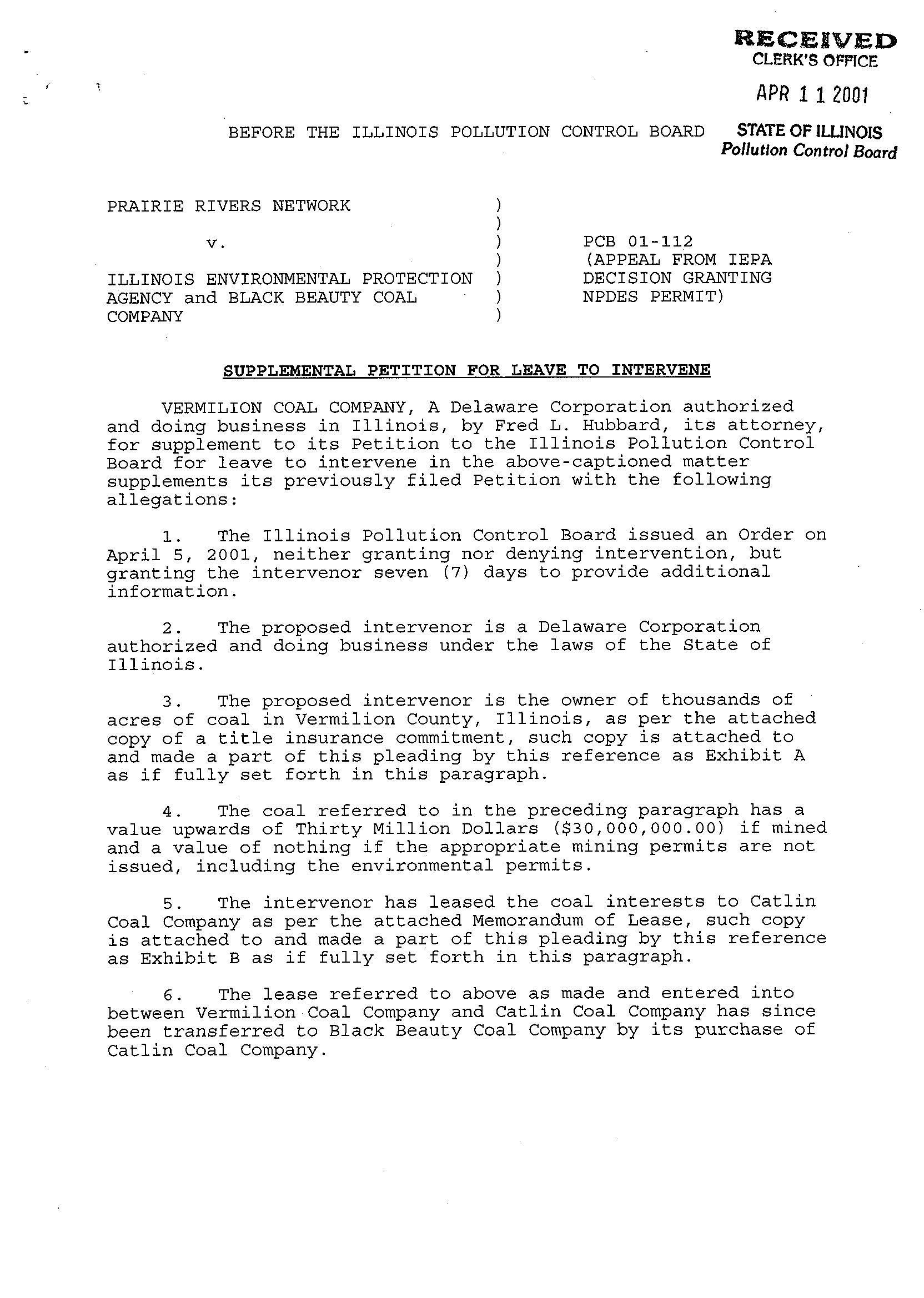
BEFORE THE ILLINOIS POLLUTION CONTROL BOARD STATE OF ILLINOIS
Pollution Control Board
PRAIRIE RIVERS NETWORK
V .
PCB 01-112
(APPEAL FROM IEPA
ILLINOIS ENVIRONMENTAL PROTECTION
DECISION GRANTING
AGENCY and BLACK BEAUTY COAL
NPDES PERMIT)
COMPANY
SUPPLEMENTAL PETITION FOR LEAVE TO INTERVENE
VERMILION COAL COMPANY, A Delaware Corporation authorized
and doing business in Illinois, by Fred L
. Hubbard, its attorney,
for supplement to its Petition to the Illinois Pollution Control
Board for leave to intervene in the above-captioned matter
supplements its previously filed Petition with the following
allegations
:
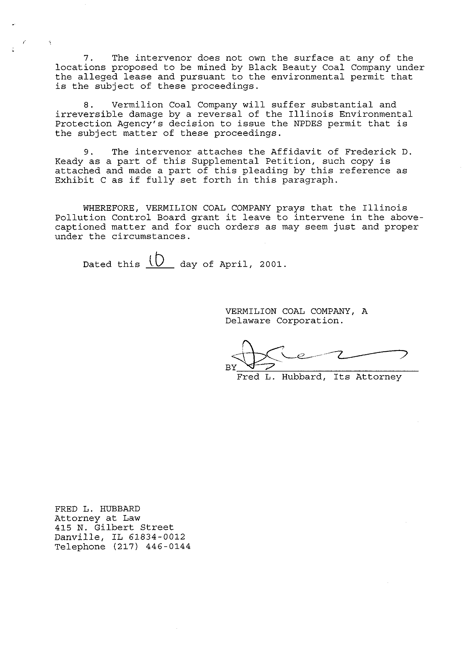
1 .
The Illinois Pollution Control Board issued an order on
April 5, 2001, neither granting nor denying intervention, but
granting the intervenor seven (7) days to provide additional
information .
2
. The proposed intervenor is a Delaware Corporation
authorized and doing business under the laws of the State of
Illinois .
3 .
The proposed intervenor is the owner of thousands of
acres of coal in Vermilion County, Illinois, as per the attached
copy of a title insurance commitment, such copy is attached to
and made a part of this pleading by this reference as Exhibit A
as if fully set forth in this paragraph
.
4 .
The coal referred to in the preceding paragraph has a
value upwards of Thirty Million Dollars ($30,000,000
.00) if mined
and a value of nothing if the appropriate mining permits are not
issued, including the environmental permits .
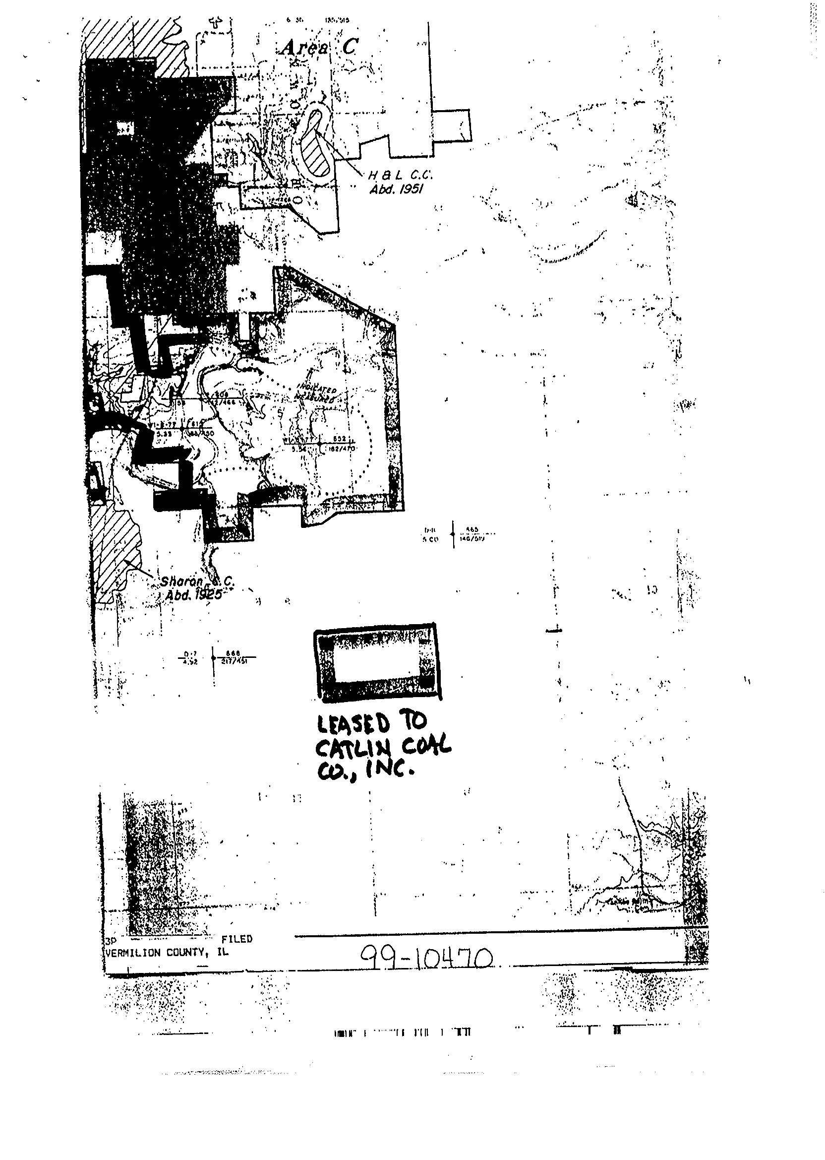
5 .
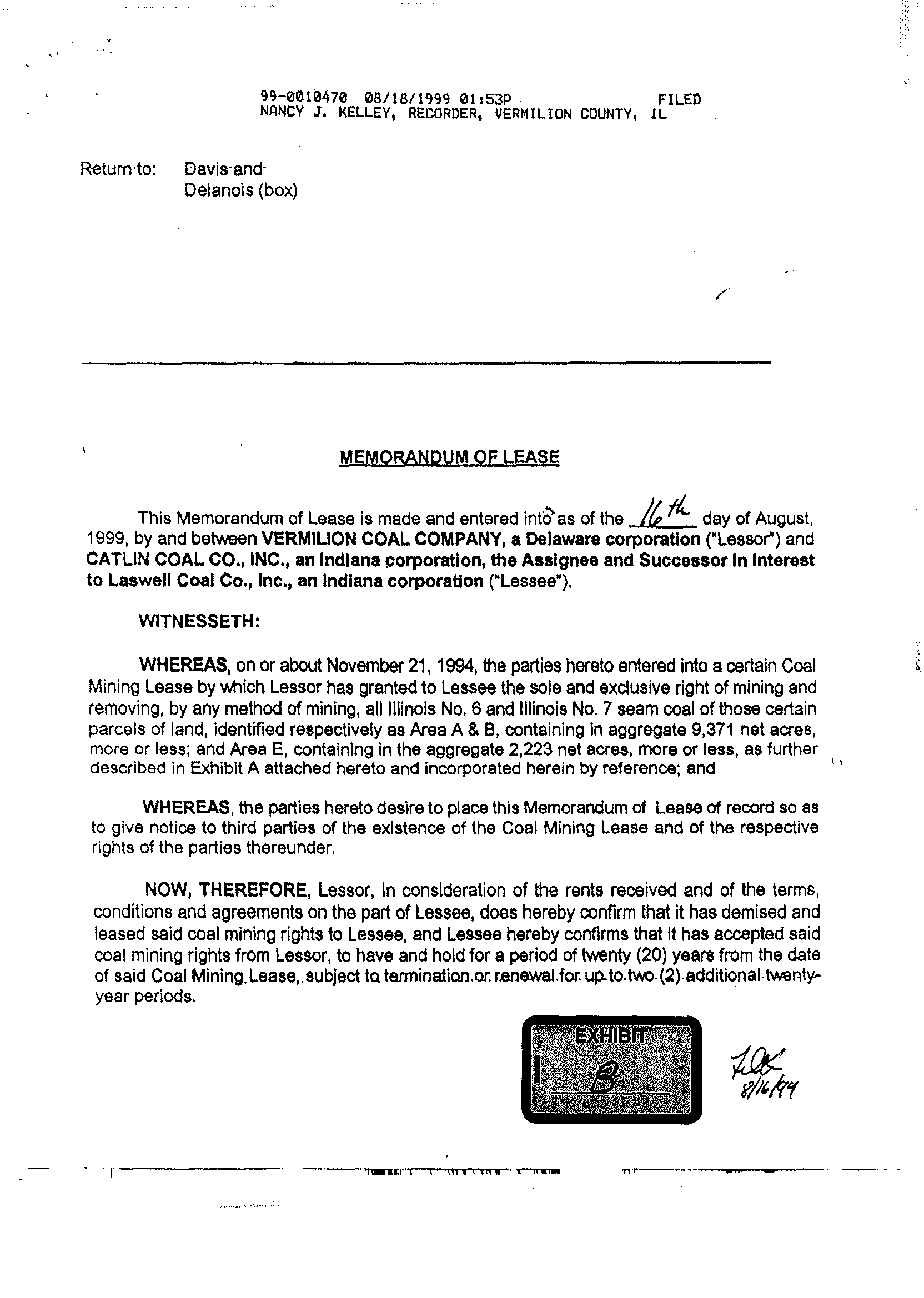
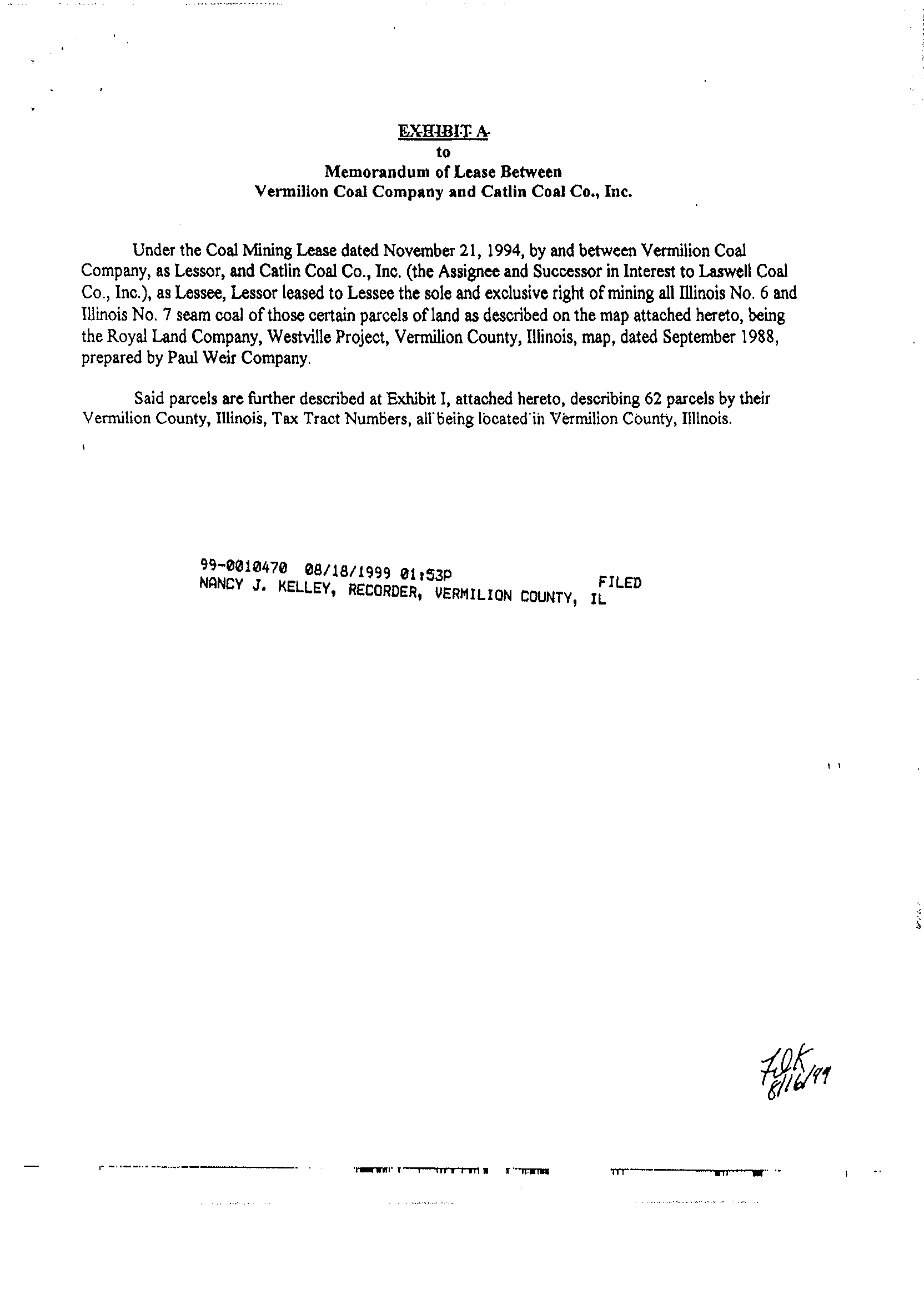
The intervenor has leased the coal interests to Catlin
Coal
is attached
Company
to
as
and
per
made
the attached
a part of
Memorandum
this pleading
of Lease,
by this
such
referencecopy
as Exhibit B as if fully set forth
in this paragraph .
6 .
The lease referred to above as made and entered into
between Vermilion Coal Company and Catlin Coal Company has since
been transferred to Black Beauty Coal Company by its purchase of
Catlin Coal Company
.
7 .
The intervenor does not own the surface at any of the
locations proposed to be mined by Black Beauty Coal Company under
the
is the
alleged
subject
lease
of
and
these
pursuant
proceedingsto
the
.
environmental permit that
8 .
Vermilion Coal Company will suffer substantial and
irreversible damage by a reversal of the Illinois Environmental
Protection Agency's decision to issue the NPDES permit that is
the subject matter of these proceedings .
9 .
The intervenor attaches the Affidavit of Frederick D
.
Keady as a part of this Supplemental Petition, such copy is
attached and made a part of this pleading by this reference as
Exhibit C as if fully set forth in this paragraph .
Pollution
WHEREFORE,
Control
VERMILION
Board grant
COAL
it
COMPANY
leave
prays
to intervene
that the
in
Illinoisthe
above-
captioned matter and for such orders as may seem just and proper
under the circumstances .
Dated this (0
day of April, 2001 .
VERMILION COAL COMPANY, A
Delaware Corporation .
BY -1-7
Fred L . Hubbard, Its Attorney
FRED L . HUBBARD
Attorney
415 N . Gilbert
at LawStreet
Danville, IL 61834-0012
Telephone (217) 446-0144
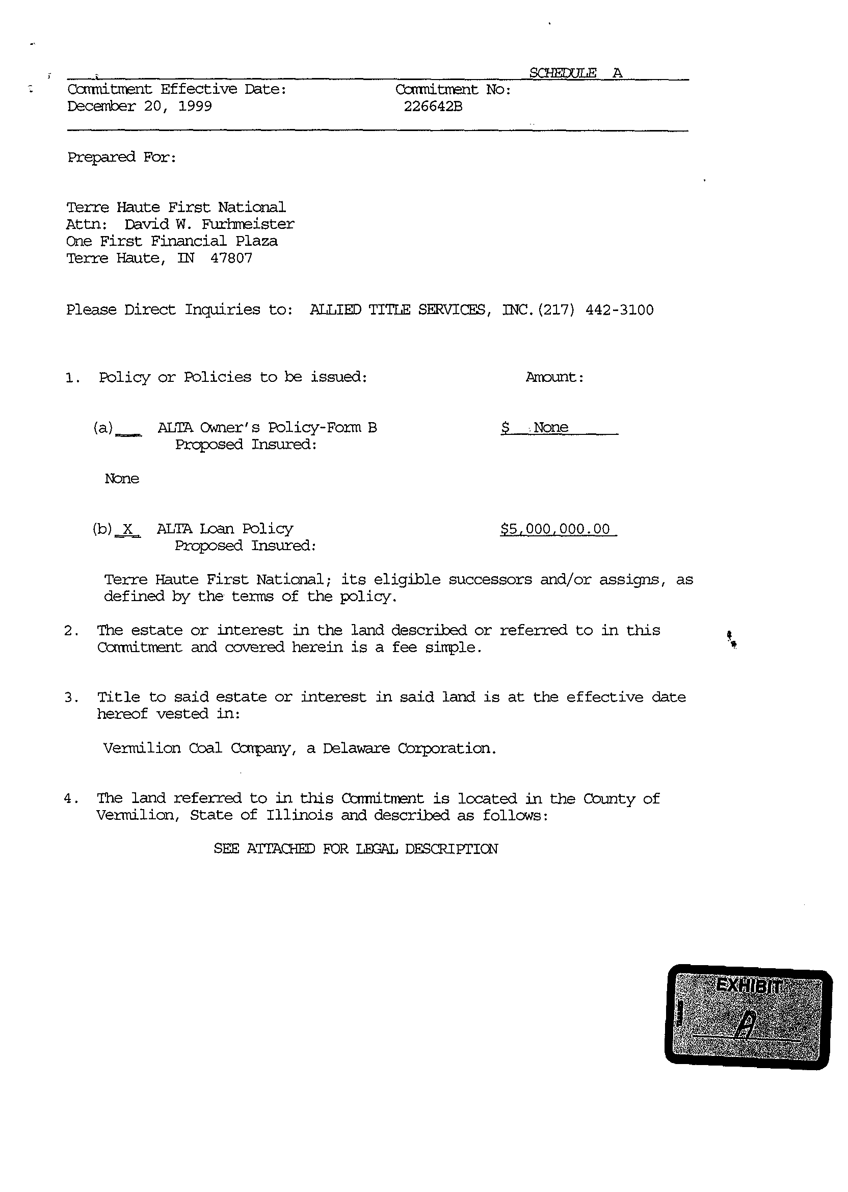
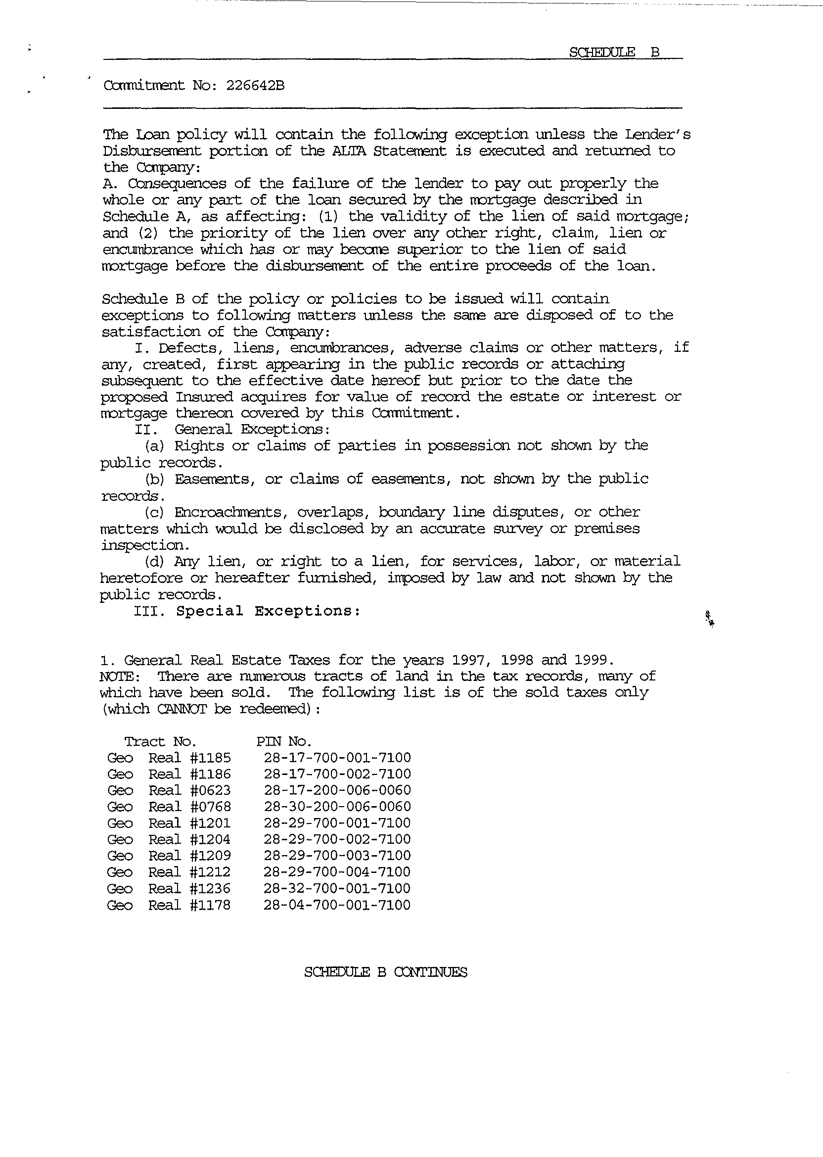
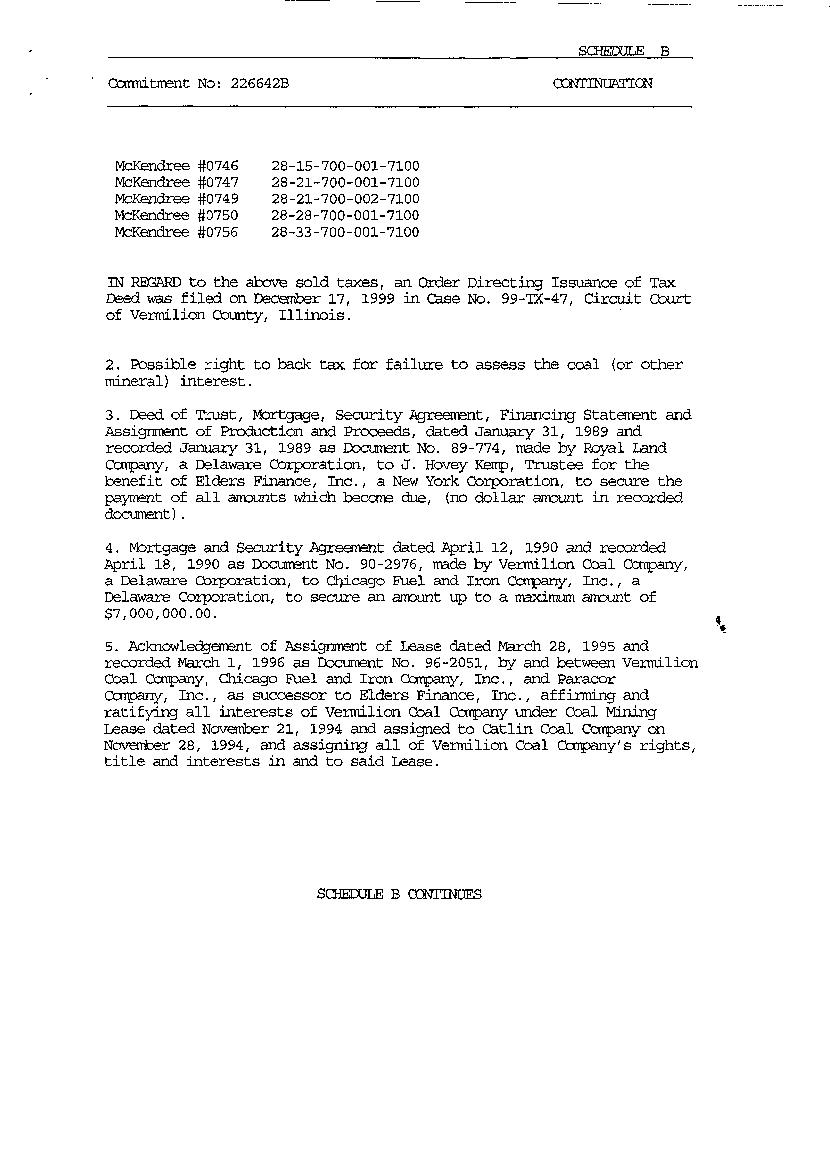
Cannitment Effective Date
:
Cannitment No :
December 20, 1999
226642B
Prepared For :
Terre Haute First National
Attn : David W . Furhmeister
One First Financial Plaza
Terre Haute, IN 47807
Please Direct Inquiries to : ALLIED TITLE SERVICES, INC . (217) 442-3100
1 . Policy or Policies to be issued :
Amount :
(a)-
ALM Owner's Policy-Form B
Proposed Insured :
$
None
None
(b) X ALTA Loan Policy
$5,000,000 .00
Proposed Insured :
Terre Haute First National ; its eligible successors and/or assigns, as
defined by the terms of the policy .
2 . The estate or interest in the land described or referred to in this
Cannitment and covered herein is a fee simple .
3 . Title to said estate or interest in said land is at the effective date
hereof vested in
:
Vermilion Coal Conpany, a Delaware Corporation .
4 . The land referred to in this CamLitment is located in the County of
Vermilion, State of Illinois and described
as
follows
:
SEE ATIPCHED FOR LEGAL DESCRIPTION
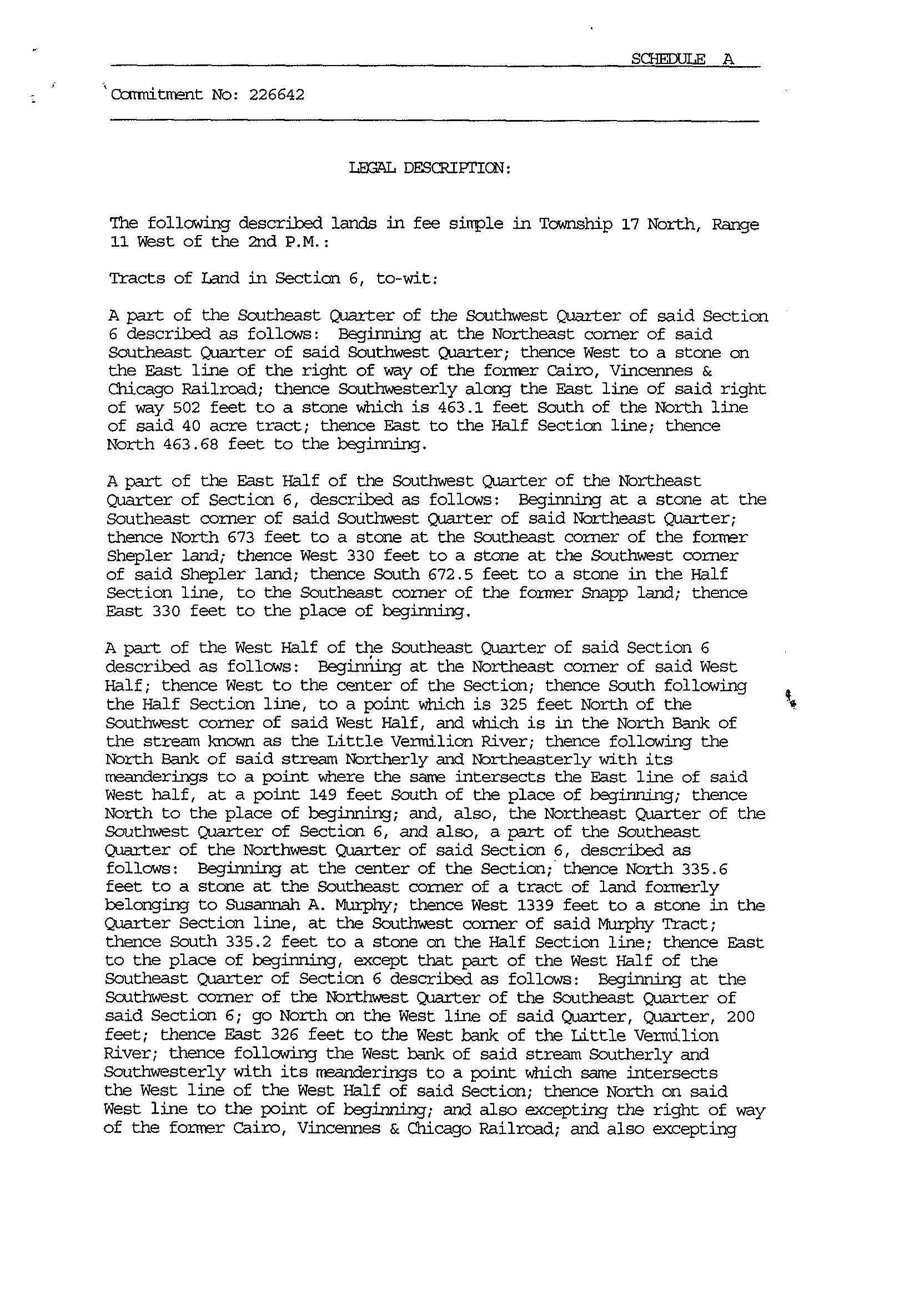
Cannitment No : 226642
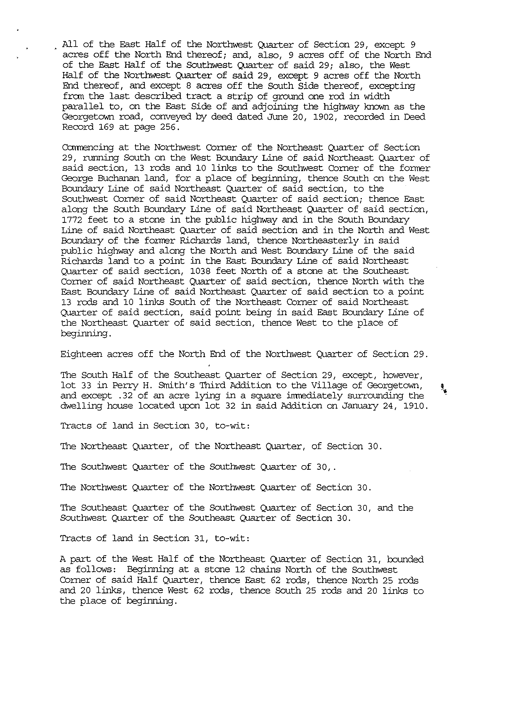
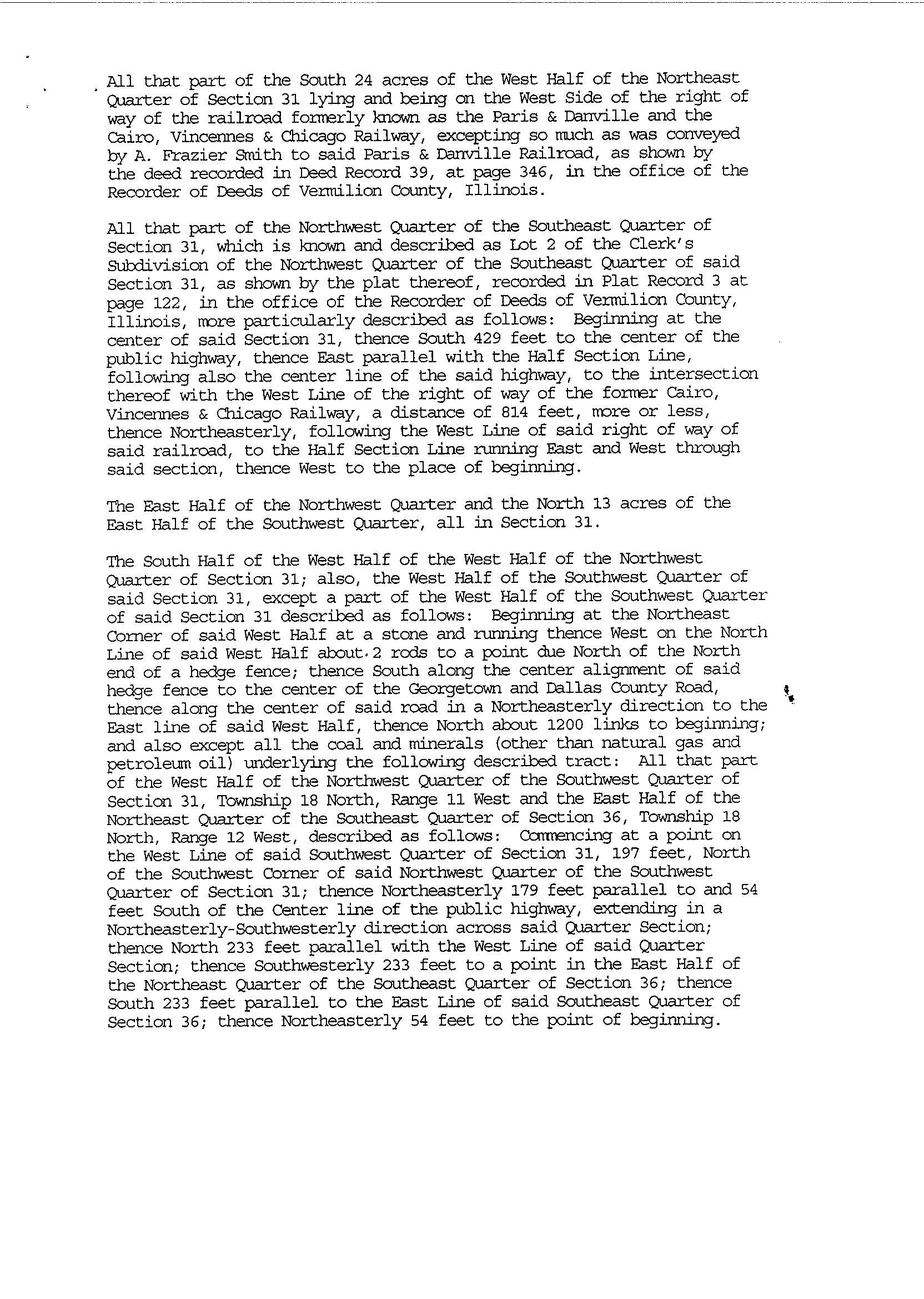
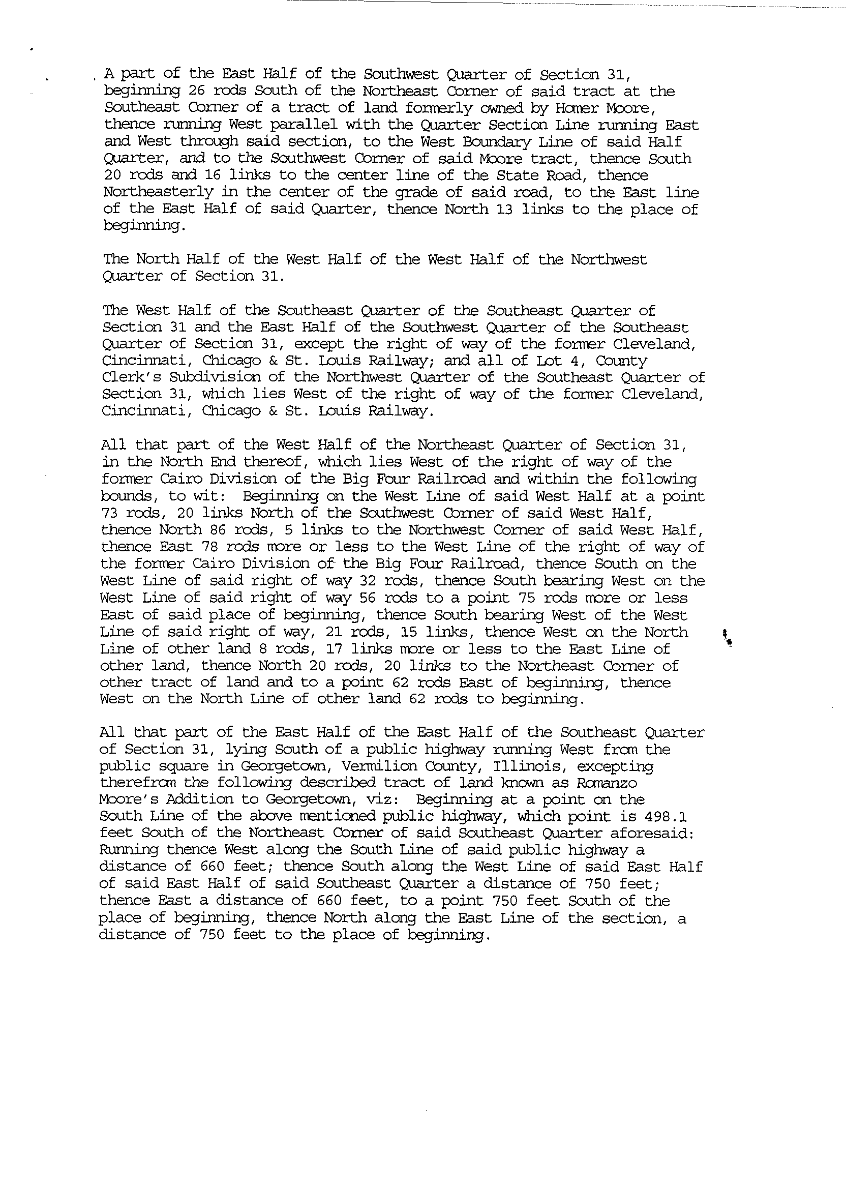
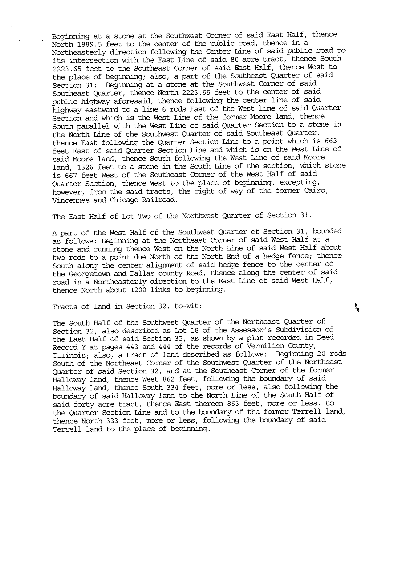
LEX3AL DESCRIPTICtT :
The following described lands in fee single in Township 17 North, Range
11 West of the 2nd P.M. :
Tracts of Land in Section 6, to-wit :
A part of the Southeast Quarter of the Southwest Quarter of said Section
6 described as follows : Beginning at the Northeast corner of said
Southeast Quarter of said Southwest Quarter ; thence West to a stone on
the
Fast line of the right of way of the former Cairo, Vincennes &
Chicago Railroad ; thence Southwesterly along the Fast line of said right
of way 502 feet to a stone which is 463 .1 feet South of the North line
of said 40 acre tract ; thence East to the Half Section line ; thence
North 463 .68 feet to the beginning .
A part of the East Half of the Southwest Quarter of the Northeast
Quarter of Section 6, described as follows : Beginning at a stone at the
Southeast corner of said Southwest Quarter of said Northeast Quarter
;
thence North 673 feet to a stone at the Southeast corner of the former
Shepler land ; thence West 330 feet to a stone at the Southwest corner
of said Shepler land ; thence South 672 .5 feet to a stone in the Half
Section line, to the Southeast corner of the former Snapp land ; thence
East 330 feet to the place of beginning .
A part of the West Half of the Southeast Quarter of said Section 6
described as follows : Beginning at the Northeast corner of said West
Half ; thence West to the center of the Section ; thence South following
the Half Section line, to a point which is 325 feet North of the
Southwest corner of said West Half, and which is in the North Bank of
the stream known as the Little Vermilion River ; thence following the
North Bank of said stream Northerly and Northeasterly with its
meanderings to a point where the same intersects the East line of said
West half, at a point 149 feet South of the place of beginning ; thence
North to the place of
beginning ;
and, also, the Northeast Quarter of the
Southwest Quarter of Section 6, and also, a part of the
Southeast
Quarter of the Northwest Quarter of said Section 6, described as
follows : Beginning at the center of the Section
; thence North 335 .6
feet to a stone at the Southeast corner of a tract of land formerly
belonging to Susannah A . Murphy ; thence West 1339 feet to a stone in the
Quarter Section line, at the Southwest corner of said Murphy Tract ;
thence South 335 .2 feet to a stone on the Half Section line ; thence East
to the place of beginning, except that part of the West Half of the
Southeast Quarter of Section 6 described as follows : Beginning at the
Southwest corner of the Northwest Quarter of the Southeast Quarter of
said Section 6 ; go North on the West line of said Quarter, Quarter, 200
feet ; thence Fast
326 feet to the West bank of the Little Vermilion
River
; thence following the West bank of said stream Southerly and
Southwesterly with its neanderings to a point which same intersects
the West line of the West Half of said Section
; thence North on said
West line to the point of beginning
; and also excepting the right of way
of the former Cairo, Vincennes & Chicago Railroad ; and also excepting
SCHEDULE A
qa
North
the
said
of
therefrun
Section
of
of
557
thence
the
line
point
said
said
South
feet
Southwest
Section
of
parallel
South
line
theSectionSection
of
East
side
a
beginningtract
Southeast600
557
on
corner
of
with
of
;
the
6feetfeet
point
thence
;
that
of
thence
Section
Quarter-Section
of
land
;
;
to
Quarter
part
of
thence
thence
theFactbeginning,
described
beginningNorth
of
line
Northeaston
of
West
Northabove
Quarter
335690
the
along
eas
;
.72
excepting
as
line,
described
feetNorthwest
thence
twardly
Quarter
followsfeetSection
center
;
1,659thence
;
West
thence
therefLun
to
of
:
tract
Quarter
.55
line
line
the
a
along
Beginning
Fastpoint
feet
West
of
lying
837
Southwest
center
parallel
of
said
16to
feet557
to
said
.5
West
a
at
the
Section,feet
stone
feet
;
line
the
QuarterSectionthenceof
WestwithEastoffcenterrightofat
;
then
of
direction
Vermilion
the
then
West
of
the
located
Section
the
way
place
Northwest
line
west
South
Northwest
of
in
6
of
to
to
of
RiverRailroad
described
on
the
a
said
the
beginningsaid
Quarter
point
Northwest
;
Quarter
west
then
Northwest
West
Carpany,
as
on
line
of
along
;
followsline
said
then
of
the
Quarter
of
the
Quarter
and
the
West
300
Southeast
East
the
:
Southeast
also
West
feet
of
BeginningSoutheast
bank
to
of
the
excepting
bank
the
to
the
500
QuarterSoutheast
the
West
Quarter
of
feet
Southeast
at
Quarter
place
said
bank
the
;
therefrom
North
then
of
river
Quarter
Southwest
of
of
of
Quarter
said
North
of
beginningthe
said
in
the
a
Section
Littleof
a
tract
along
Section
corner
Northerly200
South
said
.
feet
theof
6lineof
;
6land
;
to
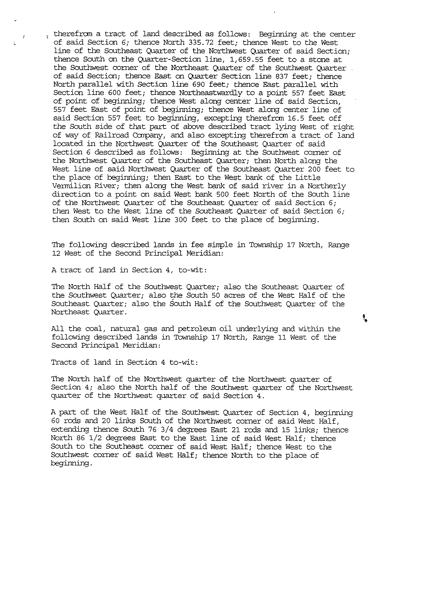
The
12 West
following
of the
described
Second Principal
lands in
Meridianfee
simple
:
in Township 17 North, Range
A tract of land in Section 4, to-wit :
The
Southeast
Northeast
the
North
Southwest
Half
QuarterQuarterQuarterof .
;
the
also
;
Southwest
also
the
the
South
QuarterSouth
Half
50
of
;
acres
also
the Southwest
the
of the
Southeast
West
Quarter
Half
Quarter
of
of
thetheof
All
Second
following
the
Principal
coal,
described
natural
Meridianlands
gas
:
and
in Township
petroleum
17
oil
North,
underlying
Range 11
and
West
within
of thethe
Tracts of land in Section 4 to-wit :
quarter
Section
The North
4of
;
half
the
also
Northwest
of
the
the
North
Northwest
quarter
half of
quarter
of
the
said
Southwest
of
Section
the Northwest
quarter
4 .
of
quarter
the Northwestof
A part of the West Half of the Southwest Quarter of Section 4,
beginning
extending
North
South
beginningSouthwest
60 rods
86
to
and
the
1/2
.
thence
corner
20
Southeast
degrees
links
South
of said
South
East
76
corner
West
3/4
to
of
the
degrees
the
Halfof
East
said
Northwest
; thence
East
line
West
21
Halfof
North
corner
roils
said
;
to
thence
of
West
and
the
said
15
Halfplace
West
linksWest
;
to
ofthenceHalf,
;
thethence
4
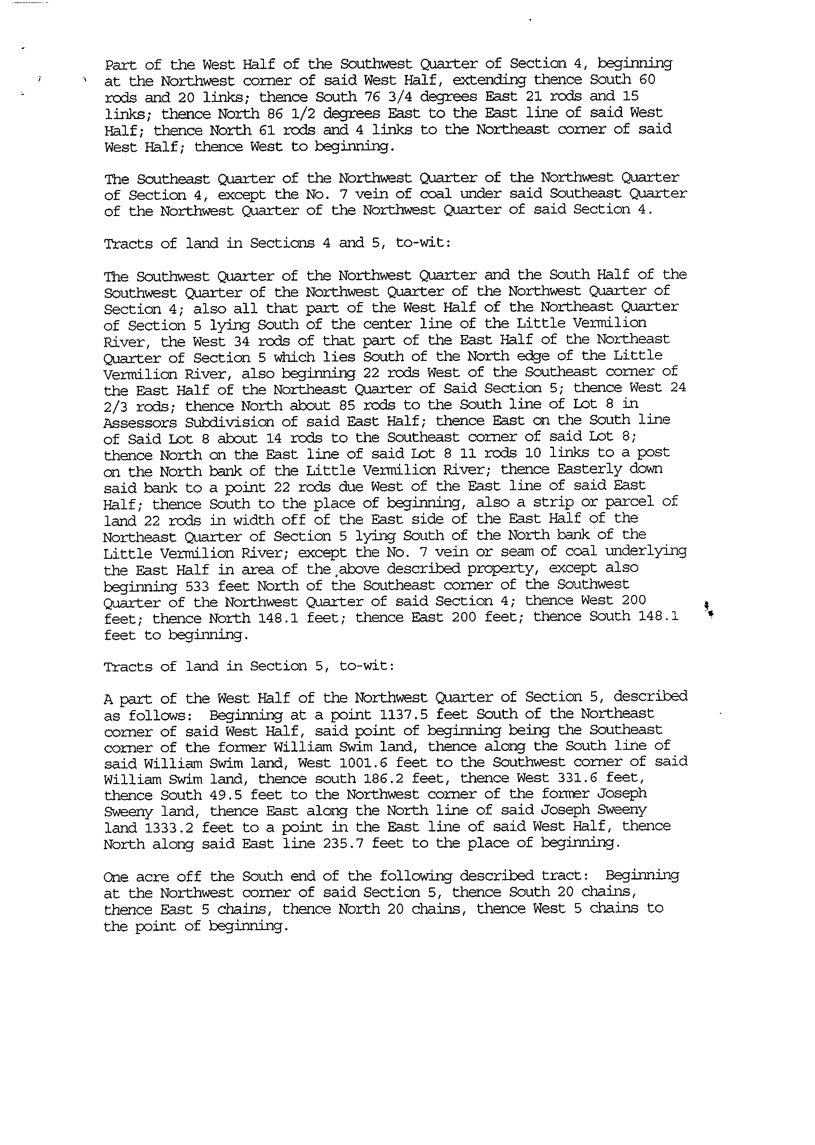
Part of the West Half of the Southwest Quarter of Section 4,
beginning
at the Northwest corner of said West Half, extending thence South 60
rods and 20 links ; thence South 76 3/4 degrees
Fast 21 rods and 15
links
; thence North 86 1/2 degrees East to the Fast line of said west
Half
; thence North 61 rods and 4 links to the Northeast corner of said
West Half
; thence West to beginning .
The Southeast
Quarter of the Northwest Quarter of the Northwest Quarter
of Section 4, except the No
. 7 vein of coal under said Southeast Quarter
of the Northwest Quarter of the Northwest Quarter of said Section 4
.
Tracts of land in Sections 4 and 5, to-wit :
The Southwest Quarter of the Northwest Quarter and the South Half of the
Southwest Quarter of the Northwest Quarter of the Northwest Quarter of
Section 4
; also all that part of the West Half of the Northeast Quarter
of Section 5 lying South of the center line of the Little Vermilion
River, the West 34 rods of that part of the East Half of the Northeast
Quarter of Section 5 which lies South of the North edge of the Little
Vermilion River, also beginning 22 rods West of the Southeast corner of
the East Half of the Northeast Quarter of Said Section 5
; thence West 24
2/3 rods
; thence North about 85 rods to the South line of Lot 8 in
Assessors Subdivision of said East Half
; thence East on the South line
of Said Lot 8 about 14 rods to the Southeast corner of said Lot 8
;
thence North on the East line of said Lot 8 11 rods 10 links to a post
on the North bank of the Little Vermilion River
; thence Easterly down
said bank to a point 22 rods due West of the East line of said East
Half
; thence South to the place of
beginning,
also a strip or parcel of
land 22 rods in width off of the East side of the East Half of the
Northeast Quarter of Section 5 lying South of the North bank of the
Little Vermilion River
; except the No
. 7 vein or seam of coal underlying
the East Half in area of the above described property, except also
beginning 533 feet North of the Southeast corner of the southwest
Quarter of the Northwest Quarter of said Section 4
; thence West 200
feet
; thence North 148.1 feet
; thence East 200 feet ; thence South 148
.1
feet to
beginning
.
Tracts of land in Section 5, to-wit :
A part of the West Half of the Northwest Quarter of Section 5, described
as follows
: Beginning at a point 1137
.5 feet South of the Northeast
corner of said West Half, said point of beginning being the Southeast
corner of the former William Swim land, thence along the South line of
said William Swim land, West 1001
.6 feet to the Southwest corner of said
William Swim land, thence south 186
.2 feet, thence West 331 .6 feet,
thence South 49
.5 feet to the Northwest corner of the former Joseph
Sweeny land, thence East along the North line of said Joseph Sweeny
land 1333
.2 feet to a point in the East line of said West Half, thence
North along said East line 235
.7 feet to the place of beginning
.
One acre off the South end of the following described tract : Beginning
at the Northwest corner of said Section 5, thence South 20 chains,
thence East 5 chains, thence North 20 chains, thence West 5 chains to
the point of
beginning .
t
4
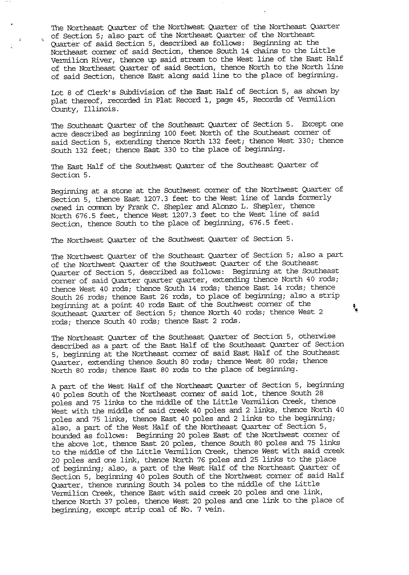
The Northeast Quarter of the Northwest Quarter of the Northeast
Quarter
of
Quarter
Section
of said
5
; also
Section
part
5,
of
described
the Northeast
as followsQuarter :
of
Beginning
the Northeastat
the
Northeast
Vermilion River,
corner
thence
of said
up
Section,
said stream
thence
to
South
the West
14 chains
line of
to
thethe
FastLittleHalf
of the
Northeast
Quarter of said Section, thence North to the North line
of said Section, thence Fast
along said line to the place of beginning .
Lot 8 of Clerk's Subdivision of the
Fast
Half of Section 5, as shown by
plat thereof, recorded in Plat Record 1, page 45, Records of Vermilion
County, Illinois .
The Southeast
Quarter of the Southeast
Quarter of Section 5 .
Except one
acre described as beginning 100 feet North of the Southeast corner of
said Section 5, extending thence North 132 feet
; thence West 330
; thence
South 132 feet
; thence East 330 to the place of beginning .
The East Half of the Southwest Quarter of the Southeast Quarter of
Section 5 .
Beginning at a stone at the Southwest corner of the Northwest Quarter of
Section 5, thence East 1207
.3 feet to the west line of lands formerly
owned in canmn by Frank C
. Shepler and Alonzo L
. Shepler, thence
North 676
.5 feet, thence West 1207
.3 feet to the West line of said
Section, thence South to the place of beginning, 676
.5 feet .
The Northwest Quarter of the Southwest Quarter of Section 5
.
The Northwest Quarter of the Southeast Quarter of Section 5
; also a part
Quarter
of the Northwest
of Section
Quarter
5, described
of the
as
Southwest
follows
Quarter
: Beginningof
the
at
Southeastthe
Southeast
corner of said Quarter quarter quarter, extending thence North 40 rods
;
thence West 40 rods
; thence $outh 14 rods
; thence East 14 rods
; thence
South 26 rods
; thence East 26 rods, to place of
beginning ;
also a strip
Southeast
beginning
Quarter
at a point
of Section
40 rods
5East
; thence
of the
North
Southwest
40 rodscorner
; thence
of theWest
2
rods
; thence South 40 rods ; thence East 2 rods
.
The
described
5, beginning
Northeast
as a
at
Quarter
part
the
of
Northeast
of
the
the
East
Southeast
corner
Half of
of
Quarter
the
said
Southeast
East
of section
Half
Quarter
of
5,
the
otherwiseof
SoutheastSection
Quarter, extending thence South 80 rods
; thence West 80 rods
; thence
North 80 rods
; thence East 80 rods to the place of
beginning .
A part of the West Half of the Northeast Quarter of Section 5,
beginning
poles
40 poles
and
South
75 links
of the
to
Northeast
the middle
corner
of the
of
Little
said
Vermilion
lot, thence
Creek,
South
thence28
poles
West with
and
the
75 links,
middle
thence
of said
East
creek
40 poles
40 poles
and
and
2 links
2 links,
to thethence
beginningNorth ;
40
also, a part of the West Half of the Northeast Quarter of Section 5,
bounded as follows
: Beginning
20 poles East of the Northwest corner of
20
the
to
poles
the
above
middle
and
lot,
one
of
thence
link,
the Little
East
thence
20
Vermilion
North
poles,
76
thence
Creek,
poles
South
and
thence
25
80
links
West
poles
with
to
and
the
said
75
placelinkscreek
of
beginning ;
also, a part of the West Half of the Northeast Quarter of
Section
Vermilion
Quarter,
thence North
5,thence
Creek,
beginning37
running
poles,
thence
40
thence
East
South
poles
with
34
South
West
poles
said
20
of
poles
creek
to
the
the
Northwest
and
20
middle
poles
one link
of
corner
and
the
to
one
Littleof
the
link,said
place
Halfof
beginning, except strip coal of No
. 7 vein .
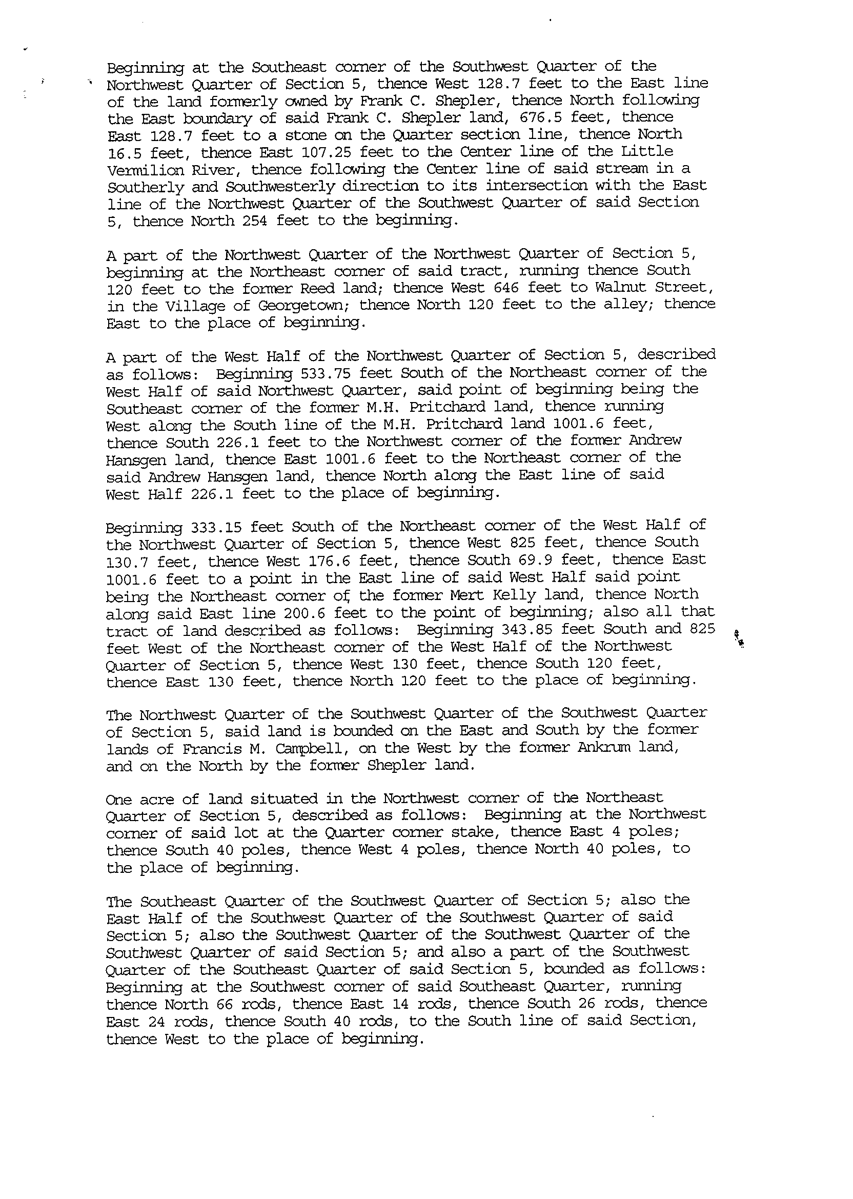
Beginning at the Southeast corner of the Southwest Quarter of the
Northwest Quarter of Section 5, thence West 128
.7 feet to the East line
of the land formerly owned by Frank C
. Shepler, thence North following
the
Fast boundary of said Frank C
. Shepler land, 676 .5 feet, thence
Fast 128
.7 feet to a stone on the Quarter section line, thence North
16
.5 feet, thence Fast 107
.25 feet to the Center line of the Little
Vermilion River, thence following the Center line of said stream in a
Southerly and Southwesterly direction to its intersection with the East
line of the Northwest Quarter of the Southwest Quarter of said Section
5, thence North 254 feet to the beginning
.
A part of the Northwest Quarter of the Northwest Quarter of Section 5,
beginning at the Northeast corner of said tract, running thence South
120 feet to the former Reed land
; thence West 646 feet to Walnut Street,
in the Village of Georgetown
; thence North 120 feet to the alley
; thence
East to the place of beginning
.
A part of the West Half of the Northwest Quarter of Section 5, described
as follows
: Beginning 533
.75 feet South of the Northeast corner of the
West Half of said Northwest Quarter, said point of
beginning
being the
Southeast corner of the former M .H
. Pritchard land, thence running
West along the South line of the M.H
. Pritchard land 1001
.6 feet,
thence South 226
.1 feet to the Northwest corner of the former Andrew
Hansgen land, thence
Fast 1001
.6 feet to the Northeast corner of the
said Andrew Hansgen land, thence North along the
Fast line of said
West Half 226
.1 feet to the place of
beginning .
Beginning 333
.15 feet South of the Northeast corner of the West Half of
the Northwest Quarter of Section 5, thence West 825 feet, thence South
130
.7 feet, thence West 176
.6 feet, thence South 69
.9 feet, thence East
1001
.6 feet to a point in the East line of said West Half said point
being the Northeast corner of
the former Mert Kelly land, thence North
along said East line 200
.6 feet to the point of beginning ;
also all that
tract of land described as follows
:
Beginning 343 .85 feet South and 825
feet West of the Northeast corner of the West Half of the Northwest
Quarter of Section 5, thence West 130 feet, thence South 120 feet,
thence East 130 feet, thence North 120 feet to the place of beginning
.
The Northwest Quarter of the Southwest Quarter of the Southwest Quarter
of Section 5, said land is bounded on the East and South by the former
lands of Francis M
. Canpbell, on the West by the former Anknum land,
and on the North by the forner Shepler land
.
One acre of land situated in the Northwest corner of the Northeast
Quarter of Section 5, described as follows :
Beginning at the Northwest
corner of said lot at the Quarter corner stake, thence East 4 poles
;
thence South 40 poles, thence West 4 poles, thence North 40 poles, to
the place of
beginning .
The Southeast Quarter of the Southwest Quarter of Section 5
; also the
East Half of the Southwest Quarter of the Southwest Quarter of said
Section 5
; also the Southwest Quarter of the Southwest Quarter of the
Southwest Quarter of said Section 5 ; and also a part of the Southwest
Quarter of the Southeast Quarter of said Section 5, bounded as follows
:
Beginning at the Southwest corner of said Southeast Quarter, running
thence North 66 rods, thence East 14 rods, thence South 26 rods, thence
East 24 rods, thence South 40 rods, to the South line of said Section,
thence West to the place of beginning .
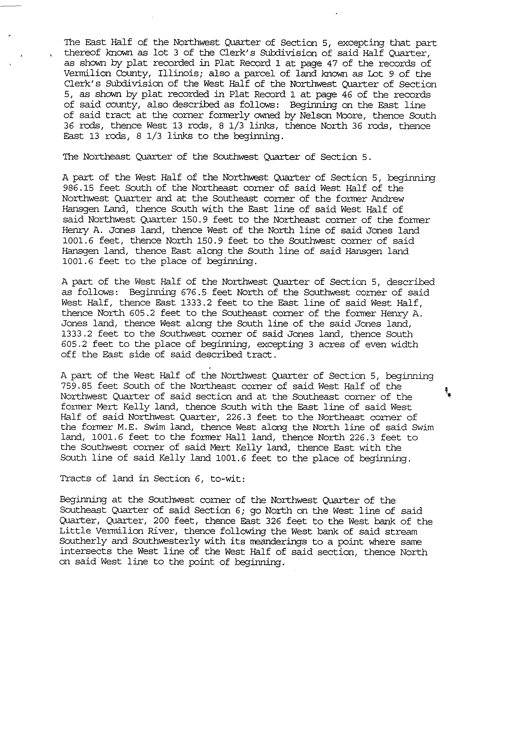
The East Half of the Northwest Quarter of Section 5, excepting that part
thereof known as lot 3 of the Clerk's Subdivision of said Half Quarter,
as shown by plat recorded in Plat Record 1 at page 47 of the records of
Vermilion County, Illinois ; also a parcel of land known as Lot 9 of the
Clerk's Subdivision of the West Half of the Northwest Quarter of Section
5, as shown by plat recorded in Plat Record 1 at page 46 of the records
of said county, also described as follows : Beginning on the Fast
line
of said tract at the corner formerly owned by Nelson Moore, thence South
36 rods, thence West 13 rods, 8 1/3 links, thence North 36 rods, thence
Fast 13 rods, 8 1/3 links to the beginning .
The Northeast Quarter of the Southwest Quarter of Section 5 .
A part of the West Half of the Northwest Quarter of Section 5, beginning
986 .15 feet South of the Northeast corner of said West Half of the
Northwest Quarter and at the Southeast corner of the former Andrew
Hansgen Land, thence South with the East line of said West Half of
said Northwest Quarter 150 .9 feet to the Northeast corner of the former
Henry A. Jones land, thence West of the North line of said Jones land
1001.6 feet, thence North 150.9
feet to the Southwest corner of said
Hansgen land, thence East along the South line of said Hansgen land
1001 .6 feet to the place of beginning .
A part of the West Half of the Northwest Quarter of Section 5, described
as follows : Beginning 676 .5 feet North of the Southwest corner of said
West Half, thence East 1333
.2 feet to the East line of said West Half,
thence North 605
.2 feet to the Southeast corner of the former Henry A .
Jones land, thence West along the South line of the said Jones land,
1333 .2 feet to the Southwest corner of said Jones land, thence South
605 .2 feet to the place of beginning, excepting 3 acres of even width
off the East side of said described tract
.
A part of the West Half of the Northwest Quarter of Section 5, beginning
759
.85 feet South of the Northeast corner of said West Half of the
Northwest Quarter of said section and at the Southeast corner of the
former Mert Kelly land, thence South with the East line of said West
Half of said Northwest Quarter, 226 .3 feet to the Northeast corner of
the former M .E
. Swim land, thence West along the North line of said Swim
land, 1001.6 feet to the former Hall land, thence North 226.3
feet to
the Southwest corner of said Mert Kelly land, thence East with the
South line of said Kelly land 1001.6
feet to the place of beginning .
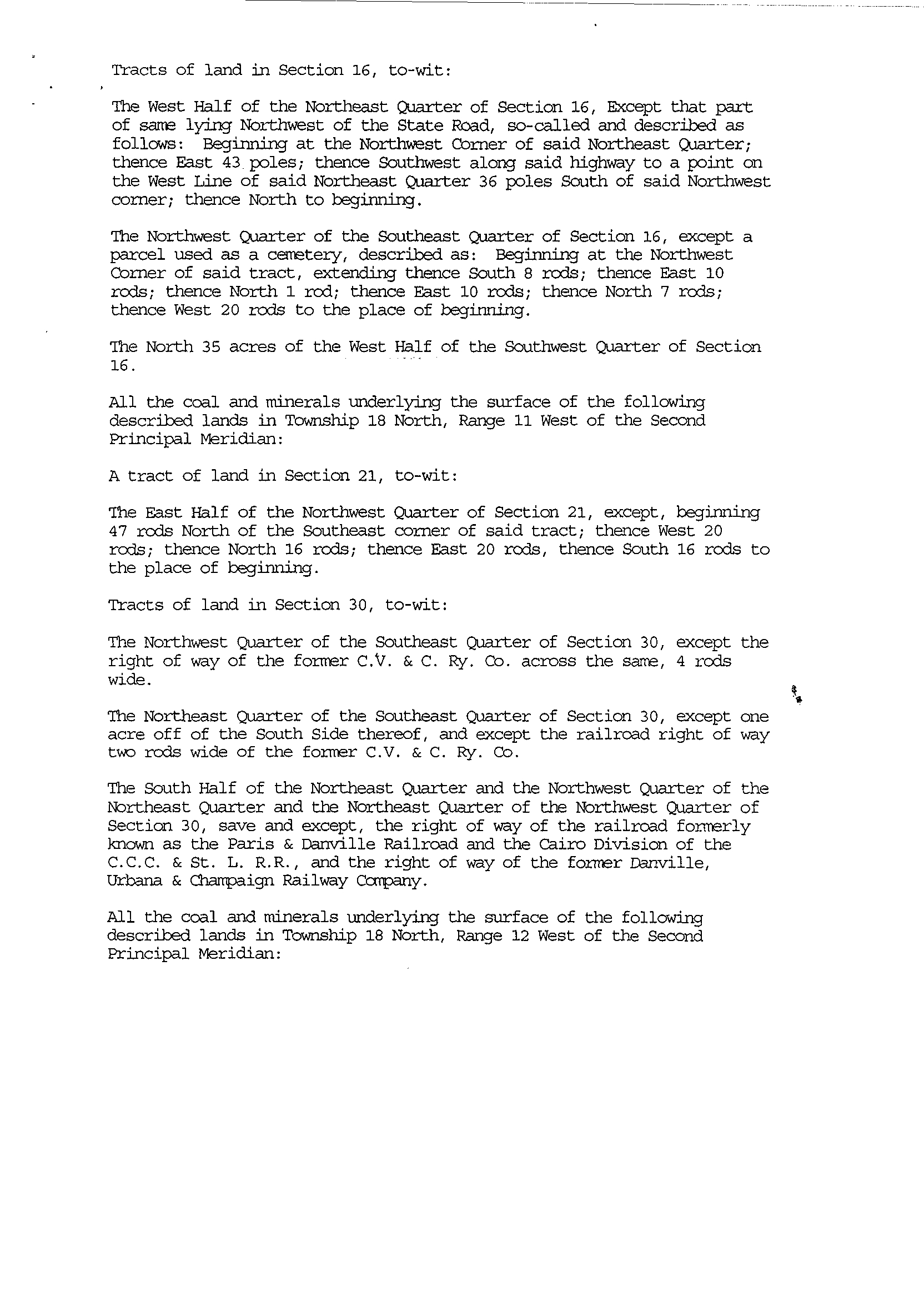
Tracts of land in Section 6, to-wit
:
Beginning
at the Southwest corner of the Northwest Quarter of the
Southeast Quarter of said Section 6
; go North on the West line of said
Quarter, Quarter, 200 feet, thence East 326 feet to the West bank of the
Little Vermilion River, thence following the West bank of said stream
Southerly and Southwesterly with its meanderings to a point where same
intersects the West line of the West Half of said section, thence North
on said West line to the point of beginning .
F uu the center of said Section 6, treasure westerly along East and West
center line of said Section 6, 568 .8 feet, thence deflecting 112 degrees
to the right measure Northeasterly 359 feet to a point of beginning,
thence continuing last described course measure Northeasterly 519 .8
feet, thence deflecting 90 degrees to the right measure Southeasterly 10
feet, thence deflecting 90 degrees to left measure North
easterly
350
feet, thence deflecting 90 degrees to the left measure Northwesterly 10
feet, thence deflecting 90 degrees to the right measure Northeasterly
211
.2 feet to the North boundary line of the Southeast Quarter of the
Northwest Quarter of said Section 6, thence deflecting 68 degrees to
right measure Easterly along North boundary line of said Southeast
Quarter of the Northwest Quarter of said Section 6, 21
.5 feet, thence
deflecting 112 degrees to right measure Southwesterly 219 .3 feet,
deflecting 90 degrees to left measure Southeasterly 15 feet, thence
deflecting 90 degrees to the right measure Southwesterly 350 feet,
thence deflecting 90 degrees to the right measure Northwesterly 15 feet,
thence deflecting 90 degrees to the left measure Southwesterly 150 feet,
thence deflecting 90 degrees to the right measure Northwesterly 10 feet,
deflecting 90 degrees to left measure Southwesterly 365
.8 feet, thence
deflecting 68 degrees to the right measure westerly 10
.8 feet to the
beginning ;
and, also beginning
at the Northeast comer of the Southeast
Quarter of the Northwest Quarter of said Section 6, said point of
beginning being 72
.6 feet distant (measured Southwesterly at right
angels) from center line of the main track of the former C .V
. & C.Ry.,
measure Westerly along the North boundary line of Southeast Quarter of
Northwest Quarter of said Section 6, 3 feet, thence deflecting 68
degrees to left measure Southwesterly 219
.3 feet, thence deflecting 90
degrees to the left measure Southeasterly 15 feet, thence deflecting 90
degrees to the right measure Southwesterly 350 feet, thence deflecting
90 degrees to right measure Northwesterly 15 feet, thence deflecting 90
degrees to left measure Southwesterly 150 feet, thence deflecting 90
degrees to right measure Northwesterly 10 feet, thence deflecting 90
degrees to left measure Southwesterly 365 .8 feet more or less to a
point, thence deflecting 112 degrees to left measure Easterly 118
.6
feet, thence deflecting 68 degrees to left measure Northeasterly 803 .1
feet, more or less, to a point in East boundary line of Southeast
Quarter of Northwest Quarter of said Section 6, thence deflecting 22
degrees and 7 minutes to left measure Northerly along East boundary line
of Southwest Quarter of Northwest Quarter of said Section 6, 258
.7 feet,
more or less, to
beginning .
A part of the West Half of the Southeast Quarter of Section 6, described
as follows :
Beginning
at a point 946
.70 feet North of the Southeast
corner of the West Half of the Southeast Quarter of said Section 6 at
the Northeast corner of the former Charles C . Parker land, thence North
following the boundary of the former Outland land, 581
.50 feet, thence
West along the South line of said Outland land, 1006
.5 feet to the North
or West edge or bank of the Little Vermilion River, and to the boundary
of the former Hewit land, thence in a Southwesterly direction up said
stream, 588 feet to a point directly West of the place of
beginning,
following in said course the West line of said river, and the East line
of said Hewit land, thence East 1005
.5 feet along the North line of
the land formerly owned by Charles C . Parker, to the place of beginning
.
s
Beginning at a stone at the Northeast corner of the Southeast Quarter of
the
Northeast
Quarter of Section 6, thence West 1671 .5 feet, more or
less, to a stone and to the Fast
line of what was formerly known as the
Snapp land, thence South following the
Fast boundary of said Snapp
land 669 feet to a stone and to the Northwest corner of what was
formerly known as the James H
. Hewit land, thence East following the
North boundary of said Hewit land 330 feet to a stone, which is the
Northeast corner of said Hewit land and which is the Northwest corner
of the land formerly owned by Frank C . Shepler, thence East, following
the North boundary of said Frank C . Shepler land, 1011
.5 feet, thence
North 66 feet, thence East 660 feet still following the North line of
said Frank C . Shepler land to the Fast
line of said Section, thence
North 600
.1 feet to the place of beginning, excepting therefrom an area
of 4 .83 acres described as follows
: Beginning at the Northeast corner
of said Southeast Quarter of said Northeast Quarter, thence West 350
feet, thence South 1 1/4 degrees West 602 feet to the South line of said
above described tract, thence East 350 feet to the West line of the
public road, thence North 1 1/4 degrees East 602 feet to the place of
beginning .
Beginning at a stone at the Northeast corner of the Southeast Quarter of
said Section 6, thence West 288 .4 feet, following the Half Section line,
thence South 5 degrees West, no magnetic variation, to the South line of
the Northeast Quarter of said Southeast Quarter, thence East, following
the Quarter Section line, 551 .1 feet to the East line of said Section,
and thence North 1341 feet to the place of beginning .
The North Half of Lot 2 of the Northwest Quarter of Section 6 .
A part of the Northeast Quarter of the Southeast Quarter of Section 6,
beginning
at the Northwest corner of said Northeast Quarter of the
Southeast Quarter of said Section, running thence East with the South
line of the former Shepler land, 1047
.35 feet to a point in the west
side of the public highway known as the State Road, thence South along
said West line of said public highway 11 degrees West 313 1/2 feet to
the former Canaday land, thence North 81 degrees and 4 minutes West
along the North line of said Canaday land 995
.25 feet to a point in
the edge of the Little Vermilion River, and in the East boundary line of
the former Hewit land, thence Northerly with the East boundary line of
said Hewit land 171 feet to the place of beginning, excepting,
however, the following portion of the above described tract :
Beginning
at the Northeast corner of said tract, thence West 23 feet, thence South
36 degrees and 9 minutes West 348
.3 feet, thence South 81 degrees and 4
minutes East 177 feet, thence North 11 degrees East 313 1/2 feet to the
place of
beginning .
¢s
A part of the West Half of
the Southeast Quarter of Section 6,
beginning
at the Southeast
corner of the Southwest Quarter of the Southwest
Quarter of the Southeast Quarter of said Section 6, running thence North
hearing
West 2 7/8 poles to a point 332-17/100 feet North of the South
line of the Southwest Quarter of the
Southeast Quarter of said Section
6, running thence Fast
685 feet to the East line of said Southwest
Quarter of said Southeast Quarter of said Section 6, thence North
614-53/100 feet to the South line of the former land of A
. W . Rhoten,
thence West with the South line of said Rhoten land 998-50/100 feet to
the Little Vermilion River, thence in a Southwesterly direction with
said river, following the meanderings thereof to a point 269-50/100 feet
North of the Southwest corner of the Southwest Quarter of the Southeast
Quarter of said Section 6, thence South with said West line of said
Quarter Quarter, 269-1/2 feet to the Southwest corner of the Southwest
quarter of the Southeast Quarter of said Section 6, thence East along
the South line of said Quarter Quarter 665-60/100 feet to the place of
beginning .
The West Half of the Southwest Quarter of Section 6, otherwise described
as Lot 2 of the Southwest Quarter of said section, except the
right-of-way of the former Cairo, Vincennes & Chicago Railroad
; also
the Southwest Quarter of the Northwest Quarter of said Section 6,
otherwise described as the South Half of Lot 2 of the Northwest Quarter
of said section .
The North Half of the East Half of the Northwest Quarter of Section 6,
excepting the right of way of the former Cairo, Vincennes & Chicago
Railroad, and excepting the triangle on the East Side of said right of
way, conveyed by a deed dated April 10, 1906, recorded in deed record
200 at page 68
.
Beginning at a stone at the Southeast corner of the Northeast Quarter of
Section 6, thence West, following the Half Section line, 1341
.5 feet to
the Southwest corner of the Southeast Quarter of the Northeast Quarter
of said Section, thence North 674 feet to a stone and to a point which
is the Northeast corner of the land formerly )mown as the James H
.
Hewit land and in the South line of the land formerly owned by Alonzo
L . Shepler, thence East 681
.5 feet, thence North 66 feet, thence East
still following the South line of said Alonzo L
. Shepler land, 660
feet to the East line of said Section, thence South 732
.9 feet to the
place of beginning ; excepting an area of 2
.31 acres described as
follows
: Beginning
at a point in the North line of the land above
described at its intersection with the west line of the public road
crossing said land from a Northerly direction to a Southerly direction,
thence West to a point which is 660 feet West of the East line of said
Section, thence south 12 rods, thence East, parallel with the North line
above mentioned, to the West line of said public road, thence
Northeasterly, following said line of said highway to the place of
beginning
.
The West Half of the Northeast Quarter of the Northeast Quarter of
Section 6 and the East Quarter of the Northwest Quarter of the Northeast
Quarter of Section 6 .
The East Half of the Northeast Quarter of the Northeast Quarter of
Section 6 .
A part of the
Southeast Quarter of the Northwest Quarter of Section 6,
described as follows
: Beginning at the Northeast corner of said forty
acre tract, thence West 1340.2
feet to a stone at the Northwest corner
of said forty acre tract, thence South to a stone on the Quarter Section
line, 1005
.6 feet, which stone is also 335
.2 feet North of the South
line of said forty acre tract, thence
Fast to the East line of said
forty acre tract, 1339 feet to a stone, which is 335
.6 feet North of the
center of said section, thence North to the
beginning
;
excepting,
however, therefiun, the right of way of the former Cairo, Vincennes &
Chicago Railroad .
A part of the West Half of the Northeast quarter of Section 6 :
Beginning at the center of the said section, thence North on the Half
Section line to the Northwest corner of said Quarter Section, thence
East to a stone on the Section line at the Northeast corner of the
former Moore land, and which is 333
.8 feet West of the Northeast corner
of said West Half, thence South following the boundaries of the former
Moore, Shepler and Hewit lands, to the Half Section line, thence
West 1007 feet to the place of beginning, excepting, however, from said
tract the right of way of the former Cairo, Vincennes and Chicago
Railroad .
A part of the Northwest Quarter of the Southeast Quarter of Section 6,
described as follows
:
Beginning
at the Southwest corner of the
Northwest Quarter of the Southeast Quarter, then North along the West
line of said Northwest Quarter of the Southeast Quarter 200 feet to the
place of beginning, then East to the West bank of the Little Vermilion
River, then along the West bank of said river in a northerly direction
to a point on said West bank 500 feet North of the South line of the
Northwest Quarter of the Southeast Quarter of said Section 6, then West
to the West line of the Southeast Quarter of said Section 6, then South
on said West line 300 feet, to the place of beginning
.
Tracts of land in Sections 6 and 7, to wit :
All of the North 30
.895 acres of the Southeast Quarter of the Northwest
Quarter of Section 6, lying East of the Right-of-Way of the Former Big
Four Railroad
.
Beginning
at the center of Section 6, thence North 335
.72 feet, thence
West to the West line of the Southeast Quarter of the Northwest Quarter
of said Section, thence South on the Quarter Section line, 1659
.55 feet
to a stone at the Southwest corner of the Northeast Quarter of the
Southwest Quarter of said Section
; thence East on Quarter Section line
837 feet, thence North parallel with Section line 690 feet, thence East
parallel with Section line 600 feet, thence Northeastwardly to a point
557 feet East of point of
beginning, thence West along center line of
said Section, 557 feet to beginning ;
EXCEPTING the Right-of-Way of the
former Big Four Railroad, and also EXCEPTING 16
.5 feet off the South
side of that part of above described tract lying West of Right-of-Way of
Railroad drip ny .
Beginning at the Northeast Corner of the Northwest Quarter of the
Northwest Quarter of Section 7, thence South on Quarter Section line
805 .56 feet, thence West to the Fast
Right-of-Way line of the former Big
Four Railroad, thence Northeastwardly along the East Right-of-Way line
to the North line of said Section, thence East along said Section line
to the point of beginning .
Beginning at the Northeast
Corner of the Northwest Quarter of the
Northwest Quarter of Section 7, thence South on Quarter Section line
780
.12 feet, thence North 30 degrees, 55 minutes, 35 seconds East,
1933
.82 feet, thence West parallel to the Section line to the East
Right-of-Way line of the former Big Four Railroad, thence
Scuthwestwardly along said East Right-of-Way line to the West Quarter
Section line of the Southeast Quarter of the Southwest Quarter of
Section 6 thence South along said Quarter Section line to
beginning
.
Beginning
at a point 780
.12 feet South of the Northeast Corner of the
Northwest Quarter of the Northwest Quarter of Section 7, thence East to
the East bank of the Little Vermilion River, thence down said stream
along its Fast
bank to the Section line between said Section 7 and
Section 6, thence
Fast
to a stone at the Southeast Corner of the
Southwest Quarter of said Section 6, thence North along Quarter Section
line 859
.03 feet, thence West 301
.26 feet to the former lands of Albert
Greene, thence South 30 degrees, 55 minutes and 35 seconds West along
the Southeasterly line of the said Albert Greene land 1933
.82 feet to
the point of
beginning .
Tracts of land in Section 7, to wit
:
A part of the Northwest Quarter of Section 7
; starting at the Northwest
Corner thereof, thence South 806 feet for a place of beginning, thence
East parallel with the Quarter Section line 1364 feet to the line
between the Northwest Quarter and the
Northeast
Quarter of said
Northwest Quarter, thence North 24 feet, thence East to the South bank
of the Little Vermilion River following in said East and North courses
the boundaries of the former Spicer and Hall lands
; thence following
said South bank to its intersection with the line between the East Half
and West Half of said Quarter Section, thence North 475 feet to the
Northeast Corner of the former Esau Starr land, thence West 1364
feet to the West line of the, Section and to a point 1501 1/2 feet South
of the Northwest Corner of the Section, thence North 694 feet to
beginning ;
EXCEPTING the Right-of-Way of the former Cairo, Vincennes &
Chicago Railroad
.
That part of Lot 2 of the Northwest Quarter of Section 7
; beginning at
the Northwest Corner of said Section, running thence East on the Section
line 1511 links to a point 17 links West of the center line of the
railroad, (formerly known as the Cleveland, Cincinnati, Chicago and St
.
Louis Railway)
; thence Southwesterly along said railroad, 17 links
distant therefrom, until 1220 links Southing have been made and to the
former land of Luther A
. Clingan
; thence West parallel with the North
Section line 1200 links to the Section line, and running with the North
line of said Clingan land, thence North 1220 links to the place of
beginning .
A part of Lot 2 of the Northwest Quarter of Section 7, described as
follows : Beginning
at a stone on the West line of the Section at a
point which is 1501.5
feet South of the Northwest corner of said Section
7, running thence South 677 feet to the South Bank of the Little
Vermilion River, thence down said stream on its South Bank to
the East
line of said lot
; thence North 475 feet on the East line of said lot to
a point 1501
.5 feet South of the North line of the Section
; thence West
1364 feet to the place of beginning,
otherwise known as Lot 10 of the
Clerk's Subdivision of the Northwest Quarter of said Section 7, as shown
by the Plat in Plat Record 1, page 45, of the records of Vermilion
County
; EXCEPTING, however, the Right-of-Way of the former Cairo,
Vincennes & Chicago Railroad
.
Beginning
at a point on the Section line North no degrees, 35 minutes
and 15 seconds West 1733 .46 feet from the Southeast corner of the
Northeast Quarter of the Southeast Quarter of Section 12, Township 17
North, Range 12 West, thence along said Section line North no degrees,
53 minutes and 15 seconds West 143 feet to a point in the South bank of
the Little Vermilion River ; thence down said stream on its South bank by
the following described courses ; North 83 degrees, 49 minutes East, 214
feet ; thence North 59 degrees no minutes East 288 feet, thence South 67
degrees, 55 minutes East 146 feet to a point in the West Right-of-Way
line of the former C.C.C
. & St . L.R.R . ; thence South 3 degrees, 14
minutes and 25 seconds West 257 feet, along the West Right-of-Way line
of said railroad, thence South 89 degrees, 43 minutes West 578 .98 feet
to a point of beginning .
All of the coal, natural gas and petroleum oil underlying and within the
following described lands in Township 17 North, Range 12 West of the
2nd P.M
.
Tracts of land in Section 1, to-wit :
A part of Lot 1 of the Northwest Quarter of Section 1, described as
follows
: Beginning at the center of said Section, running thence North
on the Half Section line 682 feet to a stone at the Southeast Corner of
the former white land, which corner is in said Half Section line, thence
West with the line of said White land, 670 feet to a stone, thence South
with the line of said White land 682 feet to a stone in the Half Section
line, thence East on said Half Section line 670 feet to the place of
beginning
; and also a part of Lot 1 of the Northeast Quarter of said
Section 1, described as follows : Beginning at the center of said
Section, running thence North on the Half Section line 2749 feet to a
stone in the North line of said Section, thence East on the North line
of said Section, 610 1/2 feet to a stone at the Northwest Corner of the
former Spicer land, thence South with the west line of said Spicer
land 1375 1/2 feet to a stone at the Southwest Corner of said Spicer
land which is 610 1/2 feet East of said Half Section line, thence West
60 1/2 feet to the Northwest Corner of the former Malone land, thence
South 1373 1/2 feet to a stone in the Half Section line at the Southwest
Corner of said Malone land, thence West 550 feet on the Half Section
line to the place of
beginning .
The Northeast Quarter of the Southwest Quarter, and ALSO 40 Acres off of
the West side of the Southeast Quarter .
A part of the
Fast
Half of the Southwest Quarter of Section 1, described
as follows : Beginning at the Southwest Corner of said East Half, thence
East on the Section Line to a point 479 .6 feet West of the Southeast
Corner of said East Half and which is also the Southwest Corner of a
tract of land formerly owned by W . V . Jones, thence North on the West
line of said Jones tract, 615 .2 feet to a stone at the Southeast Corner
of a tract of land formerly owned by Charles Barr, thence West
parallel with the South line of the Section, to the West line of said
East Half, and to the Southwest Corner of said Barr tract, thence
South 615.2 feet to the place of beginning . ALSO the Fast Half of Lot 2
of the Northeast Quarter of Section 1 .
A part of the Southwest Quarter of the Southwest Quarter of Section 1,
described as follows : Beginning 32 rods Fact
of the Southwest corner of
said Section at the Corner of land formerly owned by Ray F
. Barnett,
thence East along said Section line
adjoining
W . V . Jones 32 rods, more
or less, to the corner of the land formerly owned by Charles E . Barr,
et al, thence by said Barr land North 80 rods, more or less, to
the land formerly owned by A
. C . Martin, thence West by said Martin land
32 rods, more or less, to the land formerly owned by Ray F . Barnett, and
thence South 80 rods, more or less, to the place of beginning .
All that part of the West Half of Lot 2 or the Northeast Quarter of
Section 1, described as
beginning
610 1/2 feet East of the Northwest
corner of said Lot 2 and at the Northeast corner of the former Lorenzo
Bennett land, running thence East on the Section line 731 1/2 feet to
the Northwest Corner of the former John F
. Spicer land, thence South
along the West line of said John F
. Spicer to the South side of said
Lot 2 and to the North line of the former James Malone land, thence
West along the South side of said Lot 2 and with the North line of said
Malone land, 733 1/2 feet to the Southeast Corner of said Lorenzo
Bennett land, thence North with the East line of said Lorenzo Bennett
land to the place of
beginning ;
ALSO, the East Half of the West Half of
the Southeast Quarter ; and ALSO the
Southeast Quarter of the Southeast
Quarter of Section 1 .
Commencing at a stone at the Northwest Corner of the Southwest Quarter
of Section 1, thence East 1073 feet to a stone at the Northwest Corner
of the former White land, thence South 1340 feet to a stone at the
Southwest Corner of said White land, thence West 1075 feet to a stone on
Section line, thence North to beginning
; ALSO, commencing at a stone at
the Southwest corner of said Section 1, thence North 1340 feet to a
stone at the Southwest Corner of the tract last named,
thence East 268 .5
feet to a stone at the Northwest corner of the former Snyder land,
thence South 1340 feet to a stone on the Section line at the Southwest
Corner of said Snyder land, thence West 268
.8 feet to place of beginning .
Co mencing at the Southwest corner of the East Half of the Southwest
Quarter of Section 1, thence North 615
.2 feet for a place of beginning,
which place of beginning is the Northwest Corner of a tract of land
formerly owned by Lemon C . Hewitt and Nellie
M . Hewitt, thence North
707
.5 feet to a stone at the Southwest Corner of land fornerly owned by
Annstead Ward, thence East 672
.2 feet to a stone, thence North 18
.8
feet to a stone, thence East 192 .7 feet to a stone at the Northwest
Comer of land formerly owned by W . V
. Jones, thence South 725 feet to a
stone at the Northeast Corner of said Hewitt land, thence West 866
feet to the place of beginning
; ALSO, commencing at the Southeast Corner
of the West Half of the Southwest Quarter of said Section 1,
thence
North 1341
.5 feet to a stone at the Southeast Corner of land formerly
owned by Joanna K . White, thence West on the Quarter Section line 268
.8
feet to a stone, thence South 1341.5
feet to the South line of the
Section, thence East 268 .8 feet to
beginning .
a
The Northeast Quarter of the Northwest Quarter of Section
1 ; ALSO a part
of Lot 1 in the Northwest Quarter of said Section 1, described as
follows : Beginning at the
Northeast Corner of said Lot 1, thence South
684
.5 feet to the Northeast Corner of a tract of land fornerly belonging
to Lorenzo Bennett, thence West 670 feet, to the Northwest Corner of
said Bennett tract, thence South 682 feet to the Half Section line, and
to the Southwest Corner of said Bennett tract, thence West 1005
.5 feet
following the Half Section line to the Southeast Corner of land formerly
owned by Jotham Lyon, thence North 1367 feet to the Quarter Section
line, thence
Fast 1675 feet to the place of beginning
; ALSO, a part of
the Northwest Quarter of the Southwest Quarter of said Section 1
;
Beginning
at the Northeast
Corner of said Quarter Quarter, thence West
267
.5 feet on the Half Section line to the Northeast Corner of a tract
of land formerly owned by Achilles C
. Martin, thence South 1340 feet to
the Quarter Section line and to the Southeast Corner of said Martin
tract, thence East 267 feet, thence North on the Quarter Section line
1343 feet to the place of beginning .
Part of the Southeast Quarter of the Southwest Quarter of Section 1,
beginning at the Northeast Corner of said 40 acre tract, thence West
following the boundary of the former Ward land 479
.6 feet to the East
line of the former Barr land, thence South following the East line of
said Barr land and of the forner Hewitt land 1340
.2 feet to the
Section line, thence East 479
.6 feet to the Southeast corner of the
Quarter Section, thence North on the Half Section line following the
West line of said Ward land, 1339 feet to the place of
beginning ;
EXCEPTING fiuit the last described tract a parcel used for school
purposes, containing 1 1/2 acres located in the Southeast Corner, and
being 265 feet in width East and West and 248 feet in length North and
South .
A part of Lot 1 of the Northwest Quarter of Section 1
:
Beginning
at a
stone on the North line of said Lot, 20 poles East of the Northwest
Corner of said lot, thence Fast 40 poles and 23 links, thence South 78
poles, and 6 links to the South line of said lot
; thence West on the
Half Section line 40 poles and 23 links to a stone, thence North 78
poles and 6 links, to the place of beginning
.
The Northeast Quarter of the Southeast Quarter of Section 1, and all of
the South Half of the Northeast Quarter of said Section 1, otherwise
described as Lot 1 of the Northeast Quarter of said Section, EXCEPT a
tract off the West side thereof described as follows
: Beginning at the
Southwest corner of said Northeast Quarter, running thence East 33 1/3
rods
; thence North 80 rods, more or less, to the North line of said lot
1 of the Northeast Quarter, thence West 33 1/3 rods th the West line of
said Northeast Quarter, thence South 80 rods more or less to the place
of
beginning .
A part of the Southwest Quarter of the Southwest Quarter of section 1
described as hereinafter set forth, and also known as lot 7 of the
Clerks Subdivision of the South Half of the Southwest of said section 1,
as shown by a Plat recorded in Plat Record 3 at page 144 of the records
of Vermilion County, Illinois, more particularly described as follows
:
Beginning at the Southeast Corner of lot 8 of said Subdivision, at a
stone which is situated 268 .8 feet, more or less, East of the Southwest
Corner of said section; thence Fast on the section line 268 .8 feet, more
or less, to the Southwest Corner of lot 6 of said Subdivision ; thence
North to the Quarter Section line, 1340 feet, more or less, to the
Northwest Corner of said lot 6, thence West with the Quarter Section
line 268 .5 feet, more or less, to the Northeast Corner of said lot 8 ;
thence South to the place of
beginning,
1340 feet, more or less .
So much of the following described tract as lies in the South Half of
the Northwest Quarter of seciton 1, otherwise described as lot 1 of the
Northwest Quarter of section 1, beginning at the Southwest Corner of
said Northwest Quarter, thence North 81 nods and 15 links, thence East
20 rods, thence South 81 rods and 15 links, thence West 20 rods to the
place of
beginning .
Tracts of land in Section 2, to-wit :
60 acres off the South side of the Southwest Quarter of section of 2
;
also 30 acres of the South side of the Southwest Quarter of Southeast
Quarter of section 2 .
100 acres of even width off the North side of the Southwest Quarter ;
also, 50 acres of even width off the North side of the West Half of the
Southeast Quarter, all in section 2 .
A part of the Northeast Quarter of section 2, described as follows :
Beginning at the Northwest Corner of said Northeast Quarter, thence
South 30 rods th the North line of the former Lyon's land, thence
Easterly along the North line of said land to a point 80 rods due East
of the West line of said Northeast quarter, in the East line of the
Northwest Quarter of said Northeas Quarter, and 18 rods due South of
the North line of
said
Northeast Quarter, which point is the Southwest
Corner of the former land of Noah Lyon, thence North 18 rods, thence
West on the North line of said Northeast Quarter of the place of
beginning
;
excepting from the last mentioned tract, however, off the
West end thereof, so much as has been heretofore conveyed for cemetery
and church purposes, and which is described as follows, viz
:
beginning
at the Northwest Corner of said Northeast Quarter, thence East 572 feet
to a stone, thence South 289 feet to a stone, thence West 359 feet to a
stone, thence South to a point in the Easterly line above described,
thence Westerly following the course of said line to the West line of
the said Northeast Quarter, thence NO th 30 rods to the place of
beginning .
The South Half of the Northwest Quarter of section 2, and the Southwest
Quarter of the Northeast Quarter of section 2 .
Commencing at a stone at the Northwest Corner of the Southeast Quarter
of the Southeast Quarter of section 2, thence East on the Quarter
section line 655 .5 feet to a stone, thence South 1340 .8 feet to a stone
in the South line of the Section
; thence West 655.6
feet to a stone at
the Southwest Corner of said 40 acre tract, thence North 1340 .8 feet to
the place of beginning .
9s
Northeasthowever,
North
purposesLot
thence
2 of
14
West
.
the
a
rods
Corner
tract
8
Northwest
rods
to
of
of
the
thence
land
the
place
Quarter
Northwest
described
South
beginning,
of
14
section
Quarter
rods,
as followsused
thence2,
of
for
excepting
said
:
Beginningchruch
Fastsection,
8
and
therefrom,rods,
at
cemeteryrunningthethence
parallel
North
1301
Northwest
Quarter
followsHalf
thence
thence
thence
West
A
of
sectiondescribed
lot
thence
thenceas
part
beginningfollows1
feet,
of
parallel
to
of
North
West,
South
of
West
Past
;
:
20
section
the
with
Beginningthe
thence
Corner
as
the
:
to
acres
40
on
Beginning
;
North
followsbearing
on
parallel
Northeast
the
the
with
East
also
the
rods
line
the
east
of
off
place
North
line
at
the
North
Half
a
section
said
to
:
the
54-1/2
South,
onpart
a
withat
Beginning
section
the
Quarter
of
ofline
stone
of
saidline
North
Quarter
the
of
said
beginning
the
the
west
poles
to
line,
of
Half
saidNorthwest
at
thereof
line,
the
side
section
Northeast
of
lot
lot
line
at
the
section,
Quarter
Northeast341
to
said
place
a
1
1,
of
.
Northeast
25
the
thereof,
stone
33640
feet
1307
said
line
Corner
section
poles
rods,
corner
of
Quarter
.5
section
running
to
30
feet
beginninglot
68
Quarter
feet
and
a
poles
of
thence
Corner
thence
poles
2,
stone,
of
1,
to
said
to
of
line
2
thence
described
said
and
a
links
South
of
a
section
to
North
;
of
South
stone,
stone,
East
103
said
thence
also
also
half
a
said
South
of
to
stone,
1/2
Half,
to
18
section
described
as
2,
a
thencethethence
a
quarterlot
westthe
part
rods,poleson
stoneboundedthe
thencerunning1,saidplaceEastof2,East
;
;
as
The East Half of the Southeast Quarter of the Southeast Quarter of
section 2 .
beginningA
of
beginningline
thence
part
the
of
of
Southeast
South
said
.
the
60
lot,
rods
to
Northeast
the
Quarter
thence
East
Southeast
of
Quarter
East
of
the
said
to
Southwest
Corner
of
the
section
theNortheast
of
SoutheastCorner
said
2, thence
lot,
Corner
of
Quarter
said
thence
North
of
Northeast
said
of
to
west
section
the
lot,toNorthQuarter2,
section
A part of
2 ;
the
beginning
East Half
60 rods
of lot
East
1 of
ofthe
the
Northeast
Southwest
Quarter
Corner
of
of
saidthe
East
Half
West
of said
to
of
lot,
the
said
beginningthence
lot 1,
South
thence
.
to
North
the Southeast
62 rods, thence
Corner
East
of said
to the
lot,
Fast
thenceline
Beginning
being
West
the
Southeast
said
said
South
by
lot,
lot,
bounded
the
at
thence
by
thence
Quarter
former
the
the
on
Southwest
the
West
former
east
of
land
East
section
60
60
of
land
rods,
rods,
byCorner
Josephus
the
of
2,
thence
to
the
thence
former
ofthe
Hollingsworthheirs
the
South
place
North
lands
Northeast
of
of
to
James
to
of
the
beginning,
the
Martha
.
Quarter
ESouth
Northwest
. Barr,
Jboundary
.
said
of
Schecter,
and
theCorner
tracton
oftheofon
North
Northeast
Beginning
of
LemanWest
60
Martha
rods,
60
by
.
rods
the
thence
Jat
Quarter
.
former
the
to
Schecter,
the
South
Southwestof
lands
place
said
to
and
the
of
section
of
Corner
on
Jotham
beginning,
South
the
of
2,
West
boundary
Lyon,
thethence
by
said
Faston
the
North
of
the
tract
Half
former
said
East
62
being
of
lot,
rods,
land
by
lot
the
bounded
thence1
of
thence
of
forner
Robert
theon
EastlandtheH
.
Tracts of land in Section 3 to-wit
:
The
Northwest Quarter of section 3 ; also, the West Half of the
Northeast
Quarter of section 3
; also the West Half of the Southeast Quarter of
section 3 ; also, the East Half of the Southwest Quarter of section 3,
also the Fast Half of the West Half of the
Southwest Quarter of section
3, excepting 10 acres in the form of a square descri
bes as follows :
beginning
at a stake which is 3244 .5 feet South of
the Northeast Corner
of said West Half of the Northeast Quarter of said section 3, and
1742
.86 feet West of the East line of the West Half of the Southeast
Quarter of said section, thence South 0 degrees, 37 minutes East 660
feet to a stake
; thence South 89 degrees 23 minutes, West 660 feet to a
stake, thence North 0 degrees 37 minutes, West 660 feet to a stake
;
thence North 89 degrees 23 minutes, East 660 feet to a stake
.
The Fast Half of the Northeast Quarter of section 3
.
The Fast Half of the Southeast Quarter of section 3
.
The West Half of the West Half of the Southwest Quarter of section 3
.
Tracts of land in Section 4, to-wit :
The Southwest Quarter of the Northwest Quarter of section 4 .
The Southwest Quarter of the Southwest Quarter of section 4 .
The East Half of the Northeast Quarter of section 4 ; the North 60 acres
of the West Half of the Northeast Quarter of section 4 ; the Southeast
Quarter of section 4, except the right-of-way of the fonner Chicago &
Eastern Illinois Railroad, known as The Grape Creek Branch .
The Northwest Quarter of the Northwest Quarter of section 4
.
The East Half of the Northwest Quarter of section 4
.
Tracts of land in Section 5, to-wit :
The East Half of the Northeast
Quarter of section 5 .
The Southeast Quarter of the Southeast Quarter of section 5 .
Part of the Northeast Quarter of the Southeast Quarter of section 5
described as follows : Beginning at the Northeast Corner of said lot ;
thence West to the point where the county road runs South
; thence South
along said raod to the Southwest Corner of said lot
; thence East to the
Southeast Corner of said lot
; thence North to the place of beginning .
Tracts of land in Section 9, to-wit :
The South Half of the Northwest Quarter of the Northeast Quarter of
section 9 ; the Southwest Quarter of the Northeast Quarter of section 9 ;
all of the Southeast Quarter of the Northwest Quarter of section 9 that
lies South and Fast
of the right-of-way of the former C
. & E . I .
Railroad
; all of the South Half of the Northeast of the Northwest of
section 9 that lies South and Fast of the right-of-way of the said C . &
E . I . Railroad ; all of the Southwest Quarter of the Northwest Quarter of
section 9 that lies Southeast of the right-of-way of the said C . & E . I .
Railroad ; the Northeast Quarter of the Southwest Quarter of section 9 ;
the North Half of the Southeast Quarter of section 9, except a cemetery
describes as beginning at a post on the South side of the State Road ;
thence 40 1/2 degrees East 8 rods and 12 1/2 links to a post ; thence
South 44 degrees East 14 rods and 10 links to a post ; thence South 40
1/2 degrees West 8 rods and 12 1/2 links to a post ; thence North 44
degrees West 14 rods and 10 links to the place of beginning .
All of the West Half of the Southwest Quarter of section 9 lying East of
the right-of-way of the former Chicago & Eastern Illinois Railroad ; the
Southeast Quarter of the Southwest Quarter of section 9 ; the South Half
of the Southeast Quarter of section 9 .
All that part of the following described tract
. of land which lies West
of the right-of-way of the railroad formerly known as the The Grape
Creek Railroad and the Chicago & Eastern Illinois Railroad, to-wit : The
West Half of the Southwest Quarter of section 9 .
All of the West Half of the Northwest Quarter of section 9, lying North
and West of the right-of-way of the former Chicago & Eastern Illinois
Railroad Carpany ; also the South 60 acres of the East Half of the
Northeast Quarter of section .9 ; the North Half of the Northeast Quarter
of the Northwest Quarter of section 9, except the right-of-way of the
said Chicago & Eastern Illinois Railroad Cargaany ; also a part of the
East Half of the Northwest Quarter of section 9
beginning
at a stone 40
rods South of the Northwest Corner therof, extending thence South 2367
links to the right-of-way of the said Chicago & Eastern Illinois
Railroad Catpany; thence Northeasterly along said right-of-way 2604
links to the center of the county road ; thence West 1160 links to the
place of beginning ; also the South 15 acres of the North Half of the
Northwest Quarter of the Northeast Quarter of section 9 .
The North Half of the Northeast Quarter of the Northeast Quarter of
section 9, except the right-of-way of the former Chicago & Eastern
Illinois Railroad, formerly known as The Grape Creek Branch, and except
a tract described as beginning at the Southeast Corner of the North Half
of the Northeast Quarter of the Northeast Quarter of said section 9 ;
thence West 200 feet ; thence North 500 feet ; thence East 200 feet ;
thence South 500 feet to beginning .
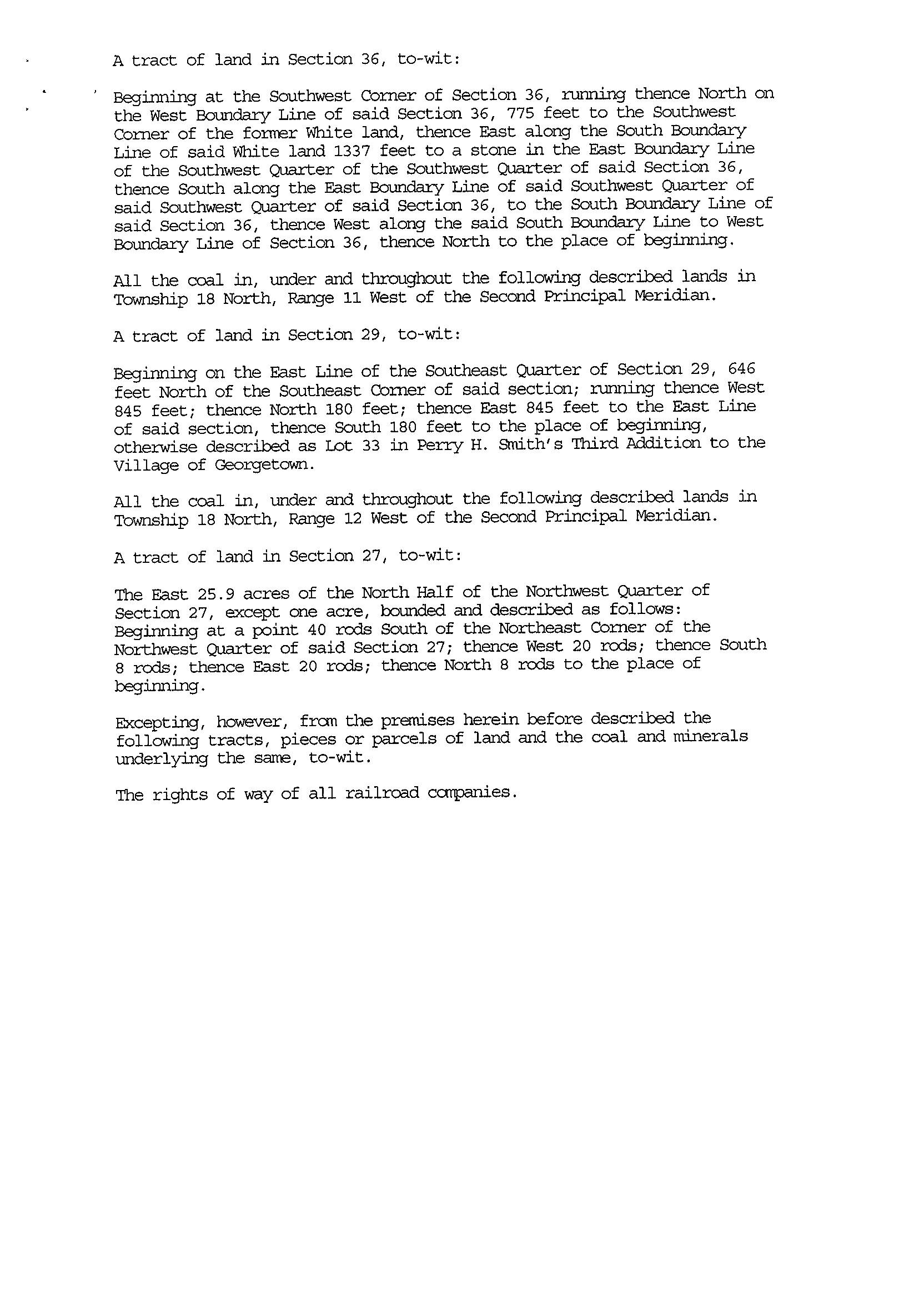
Tracts of land in Section 10, to-wit :
The Southeast Quarter of the Southeast Quarter of the Northeast Quarter
;
also the East Quarter of the Southeast Quarter
; also the Northwest
Quarter of the Northeast Quarter of the Southeast Quarter
; all in
section 10 .
The North 48 1/2 acres of the West Half of the Southwest Quarter of
section 10
.
The West Half of the Northwest Quarter of section 10, except a tract
described as beginning at the
Southeast Corner of the North Half of the
Northeast
Quarter of section 9, thence East 235 .6 feet, thence North 500
feet, thence West 235
.6 feet, thence South 500 feet to beginning, and
also except such part thereof as lies Southeasterly of the center line
of puboic road running from Indianola to Georgetown, and also except the
right-of-way of the former Chicago &
Factern Illinois Railroad, formerly
known as The Grape Creek Branch
.
The South 31 acres of the Southwest Quarter of the Southwest Quarter of
section 10
.
The Northwest Quarter of the
Southeast Quarter of section 10
; also the
Southwest Quarter of the Northeast Quarter of the Southeast Quarter
; and
the West Half of the Southeast Quarter of the Southeast Quarter of
section 10
.
The Southwest Quarter of the Southeast Quarter of the Northeast Quarter
of section 10
.
The South Half of the South two-thirds of the East Half of the Southwest
Quarter of section 10
.
The North Half of the South two-thirds of the East Half of the Southwest
Quarter of section 10
.
The Northeast Quarter of the Northeast Quarter of section 10
; and, also,
the North Half of Southeast Quarter of the Northeast Quarter of section
10 .
The West Half of the Northeast Quarter of section 10
; and, also, the
East Half of the Northwest Quarter of section 10 .
Tracts of land in Section 11, to-wit
:
Beginning 23 rods West of the Northeast Corner of the Northeast Quarter
of the Southeast Quarter of section 11, thence West 27 rods, thence
South 80 rods, thence East 27 rods, thence North 80 rods, to the place
of beginning .
Camencing at the Southeast Corner of a piece of land formerly owned by
Willis N . Kidd, for a
beginning,
which corner is the Southeast Corner
of the tract of land known as Lot 5, in the Clerk's Subdivision of the
East Half of the Northeast Quarter of Section 11, as shown by the plat
recorded in Plat Record 1, at page 54 of the records of Vermilion
County, Illinois, in the office of the Recorder of Deeds of said county,
and was formerly known as the Branam land, thence South 27 rods and 15
links to the
Northeast Corner of a tract formerly owned by A
. C . Martin ;
thence West 58 poles to the Northeast Corner of said Martin tract
;
thence North 27 poles and 15 links to the Southwest Corner of said
Branam tract
; thence East 58 poles to the place of beginning, being
the same land described in said Subdivision as Lot 6
.
4
All that part of the West Half of the Southeast Quarter of Section 11,
which lies South of the center of the Little Vermilion River, and, ALSO,
a part of the East Half of the Southeast Quarter of said Section 11,
described as follows : Beginning at a stone at the Southeast Corner of
the Section, thence North 1369 feet, more or less, to a stone at the
foot of a hill and also at the Southeast Corner of the former A . Martin
land, thence West 382 feet, more or less, to a post at the Southwest
Corner of the land formerly owned by A
. Martin, thence South to a point
which is 1335 feet North of the South line of said Section, thence West
442 feet, thence North 451 feet, thence West 494 feet to the West line
of the Fast
Half of said Southeast Quarter, following from the Southwest
Corner of said Martin land the boundary line of the land formerly known
as Dowers land, thence South 1789 feet to the Southwest Corner of the
East Half of said Southeast Quarter, thence East following the Section
line, 1320 feet to the point of
beginning .
A part of the East Half of the Southeast Quarter of Section 11,
described as follows
: Beginning at a stone at the Northwest corner of
said 80 acre tract, thence Fast
on the Half Section line 502 .5 feet to a
stone at the Northeast Corner of the former Moreland land, thence
South with the boundary of said Moreland land, 894 feet to the
Northeast Corner of the former Mills land, thence West to the Quarter
Section line, thence North with the Boundary of the former Slazas
land, to the place of beginning ; ALSO, the Southwest Quarter of the
Northeast Quarter of said Section 11 ; ALSO, beginning at a point on the
West line of the East Half of the West Half of the Southwest Quarter of
said Section 11 at a stone which is 1019.2 feet South the Half Section
line and at the Southwest Corner of said Slazas land, thence East
236 .28 feet to the center of the Little Vermilion River, thence
following said stream in its center line Eastward and also following the
boundary of said Slazas land to the point where said intersects a
North and South line which is 984 .6 feet West of the East line of the
Southwest Quarter of said Section, thence South, following said line,
which is the Boundary of the former Judd land, to the South line of
the Quarter Section; thence West 991 .5 feet to the West line of the East
Half of the West Half of the Southwest Quarter of said Section 11 and
which is the East line of the former ward land, thence following said
line North 1659 .5 feet to the place of
beginning .
A part of the Northwest Quarter of the Southeast Quarter of Section 11,
and part of the North Half of the Southwest Quarter of said Section 11,
more particularly described as follows :
Beginning
at a stone at the
Northeast Corner of the Northwest Quarter of the Southeast Quarter of
said Section 11 and at the Northwest Quarter of the former Dowers land
;
thence West of the Half Section line, to a stone which is 662 feet East
of the Northwest Corner of the Southwest Quarter of said Section 11 and
which is the Northeast Corner of the former Ward land
; thence South
following the East line of said Ward land 1019 .2 feet, parallel with the
West line of the Section, to a stone, thence East 236 .28 feet to the
center of the Little Vermilion River, thence following said stream in
its center line Eastward to the point where the same intersects the East
line of the Northwest Quarter of the Southeast Quarter of said Section
11, thence North following the West line of said Dowers land 933 feet
the the place of beginning
; ALSO, the West Half of the Southwest Quarter
of the Southeast Quarter of the Northwest Quarter of said Section 11
described as follows
: Beginning at the Southwest Corner of said
Southwest Quarter of the Southeast Quarter of the Northwest Quarter of
said Section 11 at the Southeast Corner of the former Sandusky land
;
thence North following the line of said Sandusky land 667
.35 feet to a
stone on the Quarter Section line on the South line of the forner Hester
land, thence East following 328 .25 feet
; thence South following the West
line of said Hester land, the line of said Hester land, 667
.35 feet to
the Half Section line, thence West to the beginning
.
The Southeast Quarter of the Southwest Quarter of the Northwest Quarter
of Section 11 .
Camiencing at the Northwest Corner of the Fast Half of the Northeast
Quarter of Section 11, thence
Fast 360 .6 feet to a stone, thence South
1219 feet to a stone, thence West 360 feet to a stone, thence North 1219
feet to the beginning
.
Beginning at the Southeast Corner of the Northeast Quarter of Section
11, thence North 852
.5 feet to a stone, thence West 955 feet to a stone,
thence South 842.5 feet to a stone, thence East 957 feet to the
beginning
; ALSO beginning at the Northeast Corner of the Southeast
Quarter of said Section 11, thence West 384 feet to a stone, thence
South 1290 feet to a stone, thence East 384 feet to a stone, thence
North 1295 feet, to
beginning .
The Northwest Quarter of the Northwest Quarter of Section 11 .
The South Half of the Northeast Quarter of the Northwest Quarter of
Section 11, the North Half of the Southeast Quarter of the Northwest
Quarter of Section 11 ; and 15 acres off the Fast end of the South Half
of the Southeast Quarter of the Northwest Quarter of Section 11 .
The North Half of the Southwest Quarter of the Northwest Quarter, ALSO,
the Southwest Quarter of the Southwest Quarter of the Northwest Quarter,
ALSO the West Quarter of the Southwest Quarter
; all in Section 11 .
All
that part of the following tract which lies South of the center line
of the Little Vermilion River, viz :
Beginning
at the Southeast Corner
of the Southwest Quarter of Section 11, thence North 161 rods to the
center of said Section, thence West on the Half Section line 60 rods to
the land formerly owned by Joe Slazas, thence south 160 rods, more of
less, to the South line of said Section, thence Fast 60 rods to the
place of beginning .
The North Half of the Northeast Quarter of the Northwest Quarter of
Section 11 ; and ALSO, the Northwest Quarter of the Northeast Quarter of
Section 11 .
The West Half of the following described tract of land, to-wit
:
Camrencing at a stone at the Northeast Corner of the Northeast Quarter
of Section 11, thence South on the Section line 463 feet to a stone,
thence West 950
.8 feet to a stone in the East line of a tract fornuerly
owned by Charles E . Barr, thence North 463 feet to a stone in the
North
beginningline .
of the Section, thence East 950
.8 feet to the place of
A part of the East Half of the Northeast Quarter of Section 11,
described as follows : Beginning at the Northeast Corner of said Section
11 and running thence South along its Fast line adjoining former lands
of W . V . Jones, A . M . Spicer and A . C . Martin, 84 rods and 2 1/2
links, more or less, to corner of land formerly owned by Richard E .
Swank ; thence West 58 rods, more or less, to land formerly owned by
Branam, thence North by said other land of Branam and former land of
Charles E . Barr, et al, 56 1/2 rods, more or less, to corner of
land formerly owned by C . E . Barr, et al, thence Fast by said
Barr land 29 rods, more or less, and North 27 rods, 15 links, more or
less, to North line of said Section 11 and thence Fast by said line 29
rods, more or less, to the place of beginning .
A part of the East Half of the Northeast Quarter of Section 11,
described as follows : Can ncing at the Southwest Corner of said Fast
Half, running North by West line of same adjoining former land of James
A . Dowers, 87 rods more or less, to corner of land formerly owned by
Charles E . Barr, et al, thence Fast 22 rods more or less, to line
of land last above described ; thence South by former lands of Richard E
.
Swank and A . C . Martin 87 rods, more or less, to the South line of said
East Half adjoining former land of James A . Dowers, and thence West by
said South line 22 rods, more or less, to the place of beginning
.
Tracts of land in Section 12, to-wit
:
A part of the Northwest Quarter of the Northwest Quarter of Section 12,
described as follows :
Beginning
at the Southwest Corner of said 40 acre
tract
; thence North on the Section line, 518 feet to the Southwest
Corner of a tract formerly owned by W . V
. Jones, thence East parallel
with the North line of the Section, 1039 feet to the Northwest Corner of
a tract of land formerly owned by Charles Barr ; thence South 518 feet
to the Southwest Corner of said Barr tract, to the South line of said
40 acre tract
; thence West 1043 feet to the place of beginning .
Part of the Northwest Quarter of the Northwest Quarter of Section 12,
beginning
at the Northwest Corner of said 40 acre tract, thence South
819 feet to the Northwest Corner of the former Spicer land, thence
East 1345 feet to the Quarter Section line and to the corner of the
former Barr land, following the North line of said Spicer land and
of said Barr land, thence North following the boundary of said Barr
land, 819 feet to the Section line, thence West to the beginning ; ALSO
described as 24 1/2 acres of even width off the North side of said 40
acre tract .
Sixteen acres off the North end of the East Half of the East Half of the
Northwest Quarter of Section 12 .
Beginning
20 rods West of the Northeast Corner of the Southwest Quarter
of Section 12, thence South to the center of the Little Vermilion River,
thence South along the center of said Little Vermilion River to the
South line of the North Half of the Southwest Quarter of said Section
12 ; thence Westerly along the center line of the Little Vermilion River
to the West line of said Section 12, the
North 1100 feet to the
Northwest Corner of the Southwest Quarter of said Section 12, thence
East to the place of beginning .
Beginning
, o
at
..,h
a
;
stone
..h ; a
at
a1 an
the
theSoutheast
.Gv,thwest-
Corner
rnrnerof of
the
the
Northwest
forms PlautQuarter
of
The Southwest Quarter of the
Southeast Quarter of Section 12, ALSO all
that part of the Southwest Quarter of Section 12 lying South of the
center line of the Little Vermilion River, EXCEPT that part heretofore
conveyed as shown by deed recorded in Deed Record 261 at page 495 of the
Records of Vermilion County, Illinois
; ALSO all that part of the Fast 20
acres of the Southwest Quarter of Section 12 lying North of the center
line of the Little Vermilion River .
Camuencing at the Northwest Corner of the
Fast Half of the Northwest
Quarter of Section 12, thence South 2674 feet to a stone of the Half
Section line, thence
Fast 337 feet to a stone, thence North 2674 feet to
a stone on the North line of the Section, thence West 337 feet to
beginning
; ALSO, camuencing at the Southeast Corner of the Northwest
Quarter of the Northwest Quarter of said Section 12, thence North 518
feet to a stone at the Southeast Corner of land formerly owned by W
. V .
Jones, thence West 306 feet to the
Northeast Corner of a tract of land
formerly owned by Achilles M
. Spicer, thence South 518 feet to a stone
in the Quarter Section line at the Southeast Corner of said Spicer
tract, thence Fast 303 feet to the beginning
; ALSO, cc mencing at the
Southeast Corner of the West Half of the Northwest Quarter of Section 12
aforesaid, thence North 1337
.25 feet to a stone located at the Southeast
Corner of the tract last above conveyed, thence West 673 feet to a stone
at the Northeast Corner of a tract of land formerly owned by Achille
C
. Martin, thence South 1337
.25 feet to a stone in the Half Section line
at the Southeast Corner of said Martin land, thence East 674
.25 feet to
the beginning .
Camuencing at the Southwest Corner of the Northwest Quarter of Section
12, thence North 1337 .25 feet to the Southwest Corner of the former A
.
M
. Spicer land, thence East 673 feet to the Northwest Corner of the
former Charles E . Barr land, thence South 1337 feet to the Southwest
Corner of said Barr land, thence West 674
.25 feet to beginning .
A part of the Northeast Quarter of Section 12, beginning at the center
4a
of the Section, thence North 1004
.2 feet to the Southwest Corner of the
former AnkrLun land, thence East to the Quarter Section line, 1344
feet, thence North 21 feet to the Southwest Corner of the former Hall
land, thence East 676
.8 feet to the Southeast Corner of said Hall land,
thence North to the Section line 1660
.8 feet, thence East to the
Northeast Corner of the Section, thence South on the Section line 2131
.6
feet to the south bank of the Little Vermilion River, thence following
said bank of said stream Westward and Southwesterly to it's intersection
with the Half Section line, thence West 1679 feet to the place of
beginning, EXCEPTING the right-of-way of the former Cairo, Vincennes
and Chicago Railroad .
Beginning at the Northwest Corner of the West Half of the
Northeast
Quarter of Section 12, thence East 80 poles to the Northeast Corner of
said West Half, thence South 39 poles to a stone, thence West 80 poles
to the West line of said West Half, thence North 39 poles to the
beginning ;
ALSO, the West Half of the Northeast Quarter of the Northeast
Quarter of said Section 12 ; and ALSO, the West Half of the
Southeast
Quarter of the Northeast Quarter of said Section 12, EXCEPTING the South
61 reds thereof .
Beginning
at the Southwest Corner of Section 15
; thence North 1442 feet
to
-,I, the rhocenter
opt
of the Little Vermilion River ; thence Fast and Northeast
o
f tha T.i
ttl e Venn l i rm
River to a point 1332.9 feet
The South Half of the North Half of the Southwest Quarter of the
Northwest Quarter of Section 13
.
The Fast
Half of the Northwest Quarter of Section 13
.
All that part of the North 50 acres of the West Half of the Northwest
Quarter of Section 13 which lies Fast
of the road or highway
.
Tracts of land in Section 14, to-wit :
The North Half of the North Half of the West Half of the
Fast Half of
the Northwest Quarter of Section 14
.
Also a part of the East Half of the Northeast Quarter of Section 14,
beginning
at the Northeast Corner of the section, thence West 1320 feet
to the West line of the Fast
Half of said Northeast Quarter, thence
South 789
.5 feet to the corner of the former Canaday land, thence East
following the boundary of said Canaday land to the
Fast
line of said
section, thence North 796 feet to the place of beginning
.
Part of the West Half of the Northwest Quarter of Section 14, described
as follows :
Beginning
at the Northwest Corner of said Half Quarter
;
thence South to the center of the Little Vermilion River
; thence down
the center of said river to the point where the East line of said Half
Quarter crosses said stream
; thence North to the Northeast Corner of
said Half Quarter
; thence West to beginning .
The East Half of the East Half of the Northwest Quarter of Section 14
.
All that part of the West Half of the Northwest Quarter of Section 14
which lies South of the Little Vermilion River .
The West Half of the Northeast Quarter of Section 14
; also a part of the
Fast
Half of the Northeast Quarter of Section 14, described as beginning
48 rods South of the Northeast Corner thereof, extending thence West 80
rods, thence South 48 rods, thence Fast
80 rods, thence North 48 rods to
the
beginning ;
also a part of the Northeast
Quarter of the Southeast
Quarter of Section 14, described as beginning at the Northwest Corner
thereof,
thence 48extending
.28 rods,
thence
thence
South
West 2848.28
.28
rods
rods,
to
thence
the beginningEast
28
.28
; also
rods,a
part
of the East Half of the Southeast Quarter of Section 14 described as
:
beginning 24 rods North of the Southwest Corner thereof extending thence
North 87 rods, thence East 2 rods, thence South 87 rods, thence West 2
rods to
beginning .
The West Half of the Southeast Quarter of the Northwest Quarter of
Section 14
; also the Southwest Quarter of the Northeast
Quarter of the
Northwest Quarter of Section 14
.
Tracts of land in Section l5, to-wit-
The Fast
Half of the Northwest Quarter of Section 28, excepting frul the
above described lands, a tract described as follows, to-wit
: Beginning
at a point 1246 feet Fast
of the Northwest Corner of Section 28, thence
South on the Center line of the Northwest Quarter of said Section 28,
357
.5 feet, thence Fast
539 feet, thence North 349 .5 feet to the North
line of Section 28, thence West to the place of beginning, said
exception containing 4
.35 acres .
The West Half of the Southwest Quarter of the Southwest Quarter of
Section 28 .
The South Half of the Northwest Quarter of the Southwest Quarter of
Section 28
; also the East Half of the Southwest Quarter of the Southwest
Quarter of Section 28 .
The South Half of the Southeast Quarter of the Southwest Quarter of
Section 28
.
The Northeast Quarter of the Southwest Quarter of Section 28, and the
North One Half of the Southeast Quarter of the Southwest Quarter of
Section 28 .
The North Half of the Northwest Quarter of the Southwest Quarter of
Section 28 .
Tracts of land in Section 29, to-wit :
Eight Acres off the South End of the West Half of the Northwest Quarter,
and 43 acres off the North End of the West Half of the Southwest
Quarter
; all in Section 29, otherwise described as, beginning
on the
Section line at the Southwest Corner of the fomer Sarah R
. Buchanan
land in the West Half of the-Northwest Quarter of said Section 29,
running thence South on said Section line, to the Northwest Corner of
the former Perry Frazier land in the West Half of the Southwest
g`
Quarter of said Section 29, thence East along the North line of said
Perry Frazier land, to the East line of the West Half of the Southwest
Quarter of said Section 29, thence North along the East line of the West
Half of the Southwest Quarter of said Section 29, to the Southeast
Corner of the West Half of the Northwest Quarter of said Section 29,
thence North on the Fast
Line of the West Half of the Northwest Quarter
of said Section 29, to the Southeast Corner of said Sarah R
. Buchanan
land, thence West along the South line of said Sarah R
. Buchanan land,
to the place of
beginning, except a strip one rod in width parallel to,
on the East Line of, and adjoining to the highway known as the
Georgetown Road extending from the Northern corporate limits of the
Village of Georgetown, North 102 reds, more or less, to the South Line
of the said land of Sarah R
. Buchanan, in the South Half of said
Section, described in a deed frua J
. M . Frazier and wife, to the
Danville, Paxton & Northern Railroad, recorded on page 257 of Voles
169 of the Deed Records of Vermilion County, Illinois
.
The North Half of the Southeast Quarter of Section 29 ; and, also, a part
of the Southeast Quarter of the
Northeast Quarter of said Section 29,
described as follows : Beginning
at the Southeast Corner of the
Northeast Quarter of said Section, thence North 62 rods and 17 links
thence South 40 degrees West along the public road 80 rods and 17 links
to the South line of said Northeast Quarter, thence East on said line to
the place of
beginning ;
the Northwest line of said last described tract
being the Southeast Line of the Hubbard land .
A strip of land 335 links wide, of even width, off the North side of the
Northeast Quarter of Section 29 .
Thirty-seven acres off the South End of the Southwest Quarter of the
Southwest Quarter of Section 29, except, however, Perry Frazier's
First and Second Additions to Georgetown, described as follows :
Beginning
at the Southwest Corner of said Section 29, running thence
North 580 feet, thence Fast to the East line of the Southwest Quarter of
the Southwest Quarter of said Section 29, thence South 580 feet to the
Southeast Corner of said Southwest Quarter of the Southwest Quarter of
said section, thence West on the South line thereof, to the place of
beginning ; and, beginning 580 feet North of the Southwest Corner of said
Section 29, running thence North 653 feet, thence East 574 feet and 7
inches, thence South 647 feet and 11 inches, thence West 577 feet and 6
inches to the place of
beginning
.
The premises hereby conveyed being
all of the Southwest Quarter of the Southwest Quarter of said Section 29
except that part thereof formerly owned by James M
. Frazier, and that
part thereof embraced in Perry Frazier's First and Second Additions to
Georgetown, aforesaid .
Beginning at a stone at the Northeast Corner of the Northwest Quarter of
Section 29, running thence South on the Half Section line 2650 .4 feet,
to the center of Section 29, which point is in the middle line of the
North and South public highway, and in the North line of the public
highway running Fast and West, each highway being of the width of 50
feet, running thence South on the Half Section line 300 feet to the
Southwest Corner of the former Sarah K . Buchanan land for a place of
beginning, running thence West along the South line of said Buchanan
land 1319 feet to a point on the West line of the East Half of said
Southwest Quarter, said point being 300 feet South of the Northwest
Corner of the East Half of said Southwest Quarter, thence South along
the West Line of the East Half of said Southwest Quarter, 1769 1/2 feet
to a stake in said line, 580 feet North of the Southwest Corner of the
East Half of said Southwest Quarter, thence East 929 feet, thence North
120 feet, thence 390 feet to a point in the middle line of the "old
plank road," which point is 700 feet North of the Southeast Corner of
the Fast Half of said Southwest Quarter of said Section 29, thence North
along the
middle
line of said "old plank road" (which is the East Line
of the East Half of said Southwest Quarter of said section), 1649 1/2
feet, to the place of
beginning .
All of the East Half of the Northwest Quarter of Section 29, except 9
acres off the North End thereof ; and, also, 9 acres off of the North End
of the East Half of the Southwest Quarter of said 29 ; also, the West
Half of the Northwest Quarter of said 29, except 9 acres off the North
End thereof, and except 8 acres off the South Side thereof, excepting
from the last described tract a strip of ground one rod in width
parallel to, on the
Fast
Side of and adjoining the highway known as the
Georgetown road, conveyed by deed dated June 20, 1902, recorded in Deed
Record 169 at page 256 .
Commencing at the Northwest Corner of the Northeast Quarter of Section
29, running South on the West Boundary Line of said
Northeast Quarter of
said section, 13 rods and 10 links to the Southwest Corner of the former
George Buchanan land, for a place of
beginning,
thence South on the West
Boundary Line of said Northeast Quarter of said section, to the
Southwest Corner of said Northeast Quarter of said section ; thence East
along the South Boundary Line of said Northeast Quarter of said section,
1772 feet to a stone in the public highway and in the South Boundary
Line of said Northeast Quarter of said section and in the North and West
Boundary of the former Richards land, thence Northeasterly in said
public highway and along the North and West Boundary Line of the said
Richards land to a point in the East Boundary Line of said Northeast
Quarter of said section, 1038 feet North of a stone at the Southeast
Corner of said Northeast Quarter of said section, thence North with the
East Boundary Line of said Northeast Quarter of said section to a point
13 rods and 10 links South of the Northeast Corner of said Northeast
Quarter of said section, said point being in said East Boundary Line of
the Northeast Quarter of said section, thence West to the place of
beginning .
Eighteen acres off the North End of the Northwest Quarter of Section 29 .
The South Half of the Southeast Quarter of Section 29, except, however,
lot 33 in Perry H . Smith's Third Addition to the village of Georgetown,
ga
and except .32 of an acre lying in a square immediately surrounding the
dwelling house located upon lot 32 in said Addition on January 24, 1910 .
Tracts of land in Section 30, to-wit :
The Northeast Quarter, of the Northeast Quarter, of Section 30 .
The Southwest Quarter of the Southwest Quarter of 30, .
The Northwest Quarter of the Northwest Quarter of Section 30 .
The Southeast Quarter of the Southwest Quarter of Section 30, and the
Southwest Quarter of the Southeast Quarter of Section 30 .
Tracts of land in Section 31, to-wit :
A part of the West Half of the Northeast Quarter of Section 31, bounded
as follows :
Beginning
at a stone 12 chains North of the Southwest
Corner of said Half Quarter, thence East 62 rods, thence North 25 rods
and 20 links, thence West 62 rods, thence South 25 rods and 20 links to
the place of beginning .
All
that part of the South 24 acres of the West Half of the Northeast
Quarter of Section 31 lying and being on the West Side of the right of
way of the railroad formerly known as the Paris & Danville and the
Cairo, Vincennes & Chicago Railway, excepting so much as was conveyed
by A
. Frazier Smith to said Paris & Danville Railroad, as shown by
the deed recorded in Deed Record 39, at page 346, in the office of the
Recorder of Deeds of Vermilion County, Illinois
.
All that part of the Northwest Quarter of the Southeast Quarter of
Section 31, which is known and described as Lot 2 of the Clerk's
Subdivision of the Northwest Quarter of the Southeast Quarter of said
Section 31, as shown by the plat thereof, recorded in Plat Record 3 at
page 122, in the office of the Recorder of Deeds of Vermilion County,
Illinois, more particularly described as follows
: Beginning at the
center of said Section 31, thence South 429 feet to the center of the
public highway, thence East
parallel
with the Half Section Line,
following also the center line of the said highway, to the intersection
thereof with the West Line of the right of way of the former Cairo,
Vincennes & Chicago Railway, a distance of 814 feet, more or less,
thence Northeasterly, following the West Line of said right of way of
said railroad, to the Half Section Line running East and West through
said section, thence West to the place of
beginning
.
The East Half of the Northwest Quarter and the North 13 acres of the
East Half of the Southwest Quarter, all in Section 31 .
The South Half of the West Half of the West Half of the Northwest
Quarter of Section 31
; also, the West Half of the Southwest Quarter of
said Section 31, except a part of the West Half of the Southwest Quarter
of said Section 31 described as follows
: Beginning at the Northeast
Corner of said West Half at a stone and running thence West on the North
Line of said West Half about.2
rods to a point due North of the North
end of a hedge fence
; thence South along the center alignment of said
hedge fence to the center of the Georgetown and Dallas County Road,
thence along the center of said road in a Northeasterly direction to the
East line of said West Half, thence North about 1200 links to beginning
;
and also except all the coal and minerals (other than natural gas and
petroleum oil) underlying the following described tract
: All that part
of the West Half of the Northwest Quarter of the Southwest Quarter of
Section 31, Township 18 North, Range 11 West and the East Half of the
Northeast Quarter of the Southeast Quarter of Section 36, Township 18
North, Range 12 West, described as follows
: Co miencing at a point on
the West Line of said Southwest Quarter of Section 31, 197 feet, North
of the Southwest Corner of said Northwest Quarter of the Southwest
Quarter of Section 31
; thence Northeasterly 179 feet parallel to and 54
feet South of the Center line of the public highway, extending in a
Northeasterly-Southwesterly direction across said Quarter Section
;
thence North 233 feet parallel with the West Line of said Quarter
Section
; thence Southwesterly 233 feet to a point in the
Fact Half of
the Northeast Quarter of the Southeast Quarter of Section 36
; thence
South 233 feet parallel to the East Line of said Southeast Quarter of
Section 36
; thence Northeasterly 54 feet to the point of beginning
.
aS
A part of the Fast Half of the Southwest Quarter of Section 31,
beginning 26 rods South of the
Northeast Corner of said tract at the
Southeast Corner of a tract of land formerly owned by Hatter Moore,
thence running West parallel with the Quarter Section Line running Fast
and West through
said section, to the West Boundary Line of said Half
Quarter, and to the Southwest Corner of said Moore tract, thence South
20 reds and 16 links to the center line of the State Road, thence
Northeasterly in the center of the grade of said road, to the
Fast line
of the East Half of said Quarter, thence North 13 links to the place of
beginning
.
The North Half of the West Half of the West Half of the Northwest
Quarter of Section 31 .
The West Half of the Southeast
Quarter of the Southeast Quarter of
Section 31 and the East Half of the Southwest Quarter of the Southeast
Quarter of Section 31, except the right of way of the former Cleveland,
Cincinnati, Chicago & St . Louis Railway ; and all of Lot 4, County
Clerk's Subdivision of the Northwest Quarter of the Southeast Quarter of
Section 31, which lies West of the right of way of the former Cleveland,
Cincinnati, Chicago & St . Louis Railway .
All that part of the West Half of the Northeast Quarter of Section 31,
in the North End thereof, which lies West of the right of way of the
former Cairo Division of the Big Four Railroad and within the following
bounds, to wit : Beginning on the West Line of said West Half at a point
73 rods, 20 links North of the Southwest Corner of said West Half,
thence North 86 rods, 5 links to the Northwest Corner of said West Half,
thence East 78 rods more or less to the West Line of the right of way of
the former Cairo Division of the Big Four Railroad, thence South on the
West Line of said right of way 32 rods, thence South bearing West on the
West Line of said right of way 56 rods to a point 75 rods more or less
East of said place of beginning, thence South bearing West of the West
Line of said right of way, 21 rods, 15 links, thence West on the North
Line of other land 8 rods, 17 links more or less to the East Line of
other land, thence North 20 rods, 20 links to the Northeast Corner of
other tract of land and to a point 62 rods East of beginning,
thence
West on the North Line of other land 62 rods to
beginning .
All that part of the East Half of the East Half of the Southeast Quarter
of Section 31, lying South of a public highway running West from the
public square in Georgetown, Vermilion County, Illinois, excepting
thereftuww the following described tract of land known as Rom-anzo
Moore's Addition to Georgetown, viz
: Beginning at a point on the
South Line of the above mentioned public highway, which point is 498
.1
feet South of the Northeast Corner of said Southeast Quarter aforesaid
:
Running thence West along the South Line of said public highway a
distance of 660 feet ; thence South along the West Line of said East Half
of said East Half of said Southeast Quarter a distance of 750 feet ;
thence Fast a distance of 660 feet, to a point 750 feet South of the
place of beginning, thence North along the East Line of the section, a
distance of 750 feet to the place of beginning .
Beginning at a stone at the Southwest Corner of said
Fast Half, thence
North 1889.5
feet to the center of the public road, thence in a
Northeasterly
direction following the Center Line of said public road to
its intersection with the
Fast
Line of said 80 acre tract, thence South
2223.65
feet to the
Southeast
Corner of said East Half, thence West to
the place of beginning
; also, a part of the Southeast Quarter of said
Section 31
: Beginning at a stone at the Southwest Corner of said
Southeast Quarter, thence North 2223
.65 feet to the center of said
public highway aforesaid, thence following the center line of said
highway eastward
to a line 6 rods East of the West line of said Quarter
Section and which is the West Line of the former Moore land, thence
South parallel
with the West Line of said Quarter Section to a stone in
the North Line of the Southwest Quarter of said Southeast Quarter,
thence East following the Quarter Section Line to a point which is 663
feet East of said Quarter Section Line and which is on the West Line of
said Moore land, thence South following the West Line of said Moore
land, 1326 feet to a stone in the South Line of the section, which stone
is 667 feet West of the Southeast Corner of the West Half of said
Quarter Section, thence West to the place of beginning, excepting,
however, frwi the said tracts, the right of way of the former Cairo,
Vincennes and Chicago Railroad .
The East Half of Lot Two of the Northwest Quarter of Section 31
.
A part of the West Half of the Southwest Quarter of Section 31, bounded
as follows
: Beginning at the Northeast Corner of said West Half at a
stone and running thence West on the North Line of said West Half about
two rods to a point due North of the North End of a hedge fence
; thence
South along the center alignment of said hedge fence to the center of
the Georgetown and Dallas county Road, thence along the center of said
road in a Northeasterly direction to the East Line of said West Half,
thence North about 1200 links to beginning .
Tracts of land in Section 32, to-wit :
The South Half of the Southwest Quarter of the Northeast Quarter of
Section 32, also described as Lot 18 of the Assessor's Subdivision of
the East Half of said Section 32, as shown by a plat recorded in Deed
Record Y at pages 443 and 444 of the records of Vermilion County,
Illinois
; also, a tract of land described as follows
: Beginning 20 rods
South of the Northeast Corner of the Southwest Quarter of the Northeast
Quarter of said Section 32, and at the Southeast Corner of the former
Halloway land, thence West 862 feet, following the boundary of said
Halloway land, thence South 334 feet, more or less, also following the
boundary of said Halloway land to the North Line of the South Half of
said forty acre tract, thence East thereon 863 feet, more or less, to
the Quarter Section Line and to the boundary of the former Terrell land,
thence North 333 feet, more or less, following the boundary of said
Terrell land to the place of
beginning .
A part of the North Half of Section 32, described as follows :
Beginning
at a stone at the Southeast Corner of the Northwest Quarter of the
Southeast Quarter of the Northwest Quarter of said Section 32, thence
West 425 feet, thence North 482 feet, following the
Fact
Line of tracts
formerly owned by the heirs of Joe Carroll, and by Joe Biggs and
Lucretia Lewis, to a point which is 264 feet East of the Northeast
Corner of Lot 5 in Mahlon Haworth's Addition to Georgetown,
Illinois, thence Fast 428 feet to a stone following the South Line of
the land formerly owned by William Olney, thence North 480 feet
following the line of land formerly owned by William Olney, H .G .
Florence, Olive Terrell and Cbrnelia Brennan, thence East 994 .5 feet,
following the South Line of land formerly owned by Elizabeth A . West,
thence South 300 feet, following the West Line of the former land of
Lillie Driskell, thence
Fact
996 feet, following the line of lands
formerly owned by Lillie Driskell, Charles Underwood and Mason Tucker,
thence South 333 feet following the line of lands formerly owned by H .
G
. Florence, Olive Terrell and Cornelia Brennan, thence West 862 feet
following the North Line of lands formerly owned by Elosia M . Clifton,
thence South 333 feet to the center of the public highway, following the
West Line of lands of said Elosia M . Clifton, thence West 1128 feet,
following the center of the public highway, to the place of
beginning .
The Northwest Quarter of the Northeast Quarter of Section 32, excepting
a tract of land 18 rods in even width off the South End of said forty
acre tract, the South Boundary of the tract being the North Boundary of
the tracts formerly known as the Tucker land, the Halloway land, the
Driscoll land, and the Clifton land .
A part of the Northeast Quarter of the Northwest Quarter of said Section
32, described as follows
:
Beginning
at the Northeast Corner of said
forty acre tract, thence South 62 rods to a point 18 rods North of the
South Line of said forty acre tract, thence West 662 feet to the East
Boundary Line of a tract of land formerly owned by the heirs of H . G .
Terrell, deceased,
thence North following the boundary line of said
Terrell tract to the North Line of the section, 1034 feet, thence East
660 feet, more or less, to the place of beginning .
Part of the Northwest Quarter of the
Northeast Quarter of the Southeast
Quarter of Section 32, described as beginning at the Northeast Corner of
said tract, extending thence South 636 feet ; thence in a Northwesterly
direction to a point in the North line of said tract 570 feet West of
the
beginning ;
thence Fast to the place of
beginning,
except, however,
the #7 or top vein of coal .
Lot 19 of Clerk's Subdivision of Section 32, as shown on Plat Record 4
at page 238, otherwise described as the Southwest Quarter of the
Southeast Quarter of the Northeast Quarter of Section 32, except,
however, the #7 or top vein of coal .
A part of the West Half of the Southeast Quarter of the Southeast
Quarter of Section 32, bounded as follows, to-wit
: Beginning at the
Southeast Corner of the said West Half and running thence North on the
Fast
Line thereof 1340 links to the
middle of the public highway
; thence
in a Northwesterly direction along the middle of said public highway to
a point 215 links Fast
of the West Line of said West Half
; thence South
800 links to a point equidistant between the North Line and the South
Line of said West Half
; thence West 15 links
; thence South to the South
Line of said West Half
; thence East 800 links to the place of
beginning,
excepting one-half acre of even width off of the East Side of that
portion of the Northwest Quarter of the Southeast Quarter of the
Southeast Quarter of Section 32 as lies South of the said public road,
also excepting one-half acre mare particularly described as
beginning
205 feet Eastwardly of the Northwest Corner of Lot 94 and along the
North Line thereof, extending thence South 240 feet
; thence East 100
feet
; thence North to the North Line of said lot
; thence Northwestwardly
along said North Line to the place of beginning, and also excepting the
seventh vein or seam of coal, saretii s called the stripping vein,
underlying the surface of said described real estate .
Lot 21 of Clerk's Subdivision of Section 32, as shown by plat thereof,
recorded in Plat Record 4 at page 238 of the records of vermilion
County, Illinois, excepting all of the coal lying within 25 feet of the
surface of said described real estate .
Lot 20 of Clerk's Subdivision of Section 32, as shown by plat thereof,
recorded in Plat Record 4 at page 238 of the records of vermilion
County, Illinois, excepting the surface and the overlying strata to a
depth of 20 feet below the surface of the property conveyed
.
Lot 22 of Clerk's Subdivision of Section 32, as shown by plat thereof,
recorded in Plat Record 4 at, page 238 of the records of Vermilion
County, Illinois .
The East Half of the Northeast Quarter of the Southwest Quarter of the
Southeast Quarter of Section 32
; also part of the Southeast Quarter of
the Southeast Quarter of said Section 32, described as
beginning at the
Northwest Corner of said tract, extending thence south on the West Line
thereof 40 rods, thence East 215 links, thence North 800 links to the
center of the Public Highway, thence in a Northwesterly direction along
the center of said Highway to the place of beginning ;
also the Southeast
Quarter of the Southwest Quarter of the Southeast Quarter of said
Section 32
; also the West Half of the Northeast Quarter of the Southwest
Quarter of the Southeast Quarter of said Section 32
; also the West two
acres of the South Half of the Southeast Quarter of the Southeast
Quarter of said Section 32 .
The East Half of the Southeast Quarter of the Northeast Quarter of
Section 32
; also the Northwest Quarter of the Southeast Quarter of the
Northeast Quarter of Section 32
; also the Northeast Quarter of the
Northeast Quarter of Section 32 ; also the Northeast Quarter of the
Northeast Quarter of the Southeast Quarter of Section 32, except the No .
7 or top vein of coal ; that is to say, all surface or strip mining in
and on the following described tracts, to-wit
: the South two acres of
the Southeast Quarter of the Southeast Quarter of the Northeast Quarter,
also the Northeast Quarter of the Northeast Quarter of the Southeast
Quarter also the West 8 acres of the Northwest Quarter of the Southeast
Quarter of the Northeast Quarter, all in said Section 32 .
s
A part of the Southeast
Quarter of the Southeast Quarter of Section 32,
described as follows
: Beginning at the Southeast Corner of said
Section, thence North 983 links to the center of the public road, thence
Northwest along the center of said road to the West Line of the
Fast
Half of the Southeast Quarter of the Southeast
Quarter of said Section,
thence South to the South Line of said Section, thence East to the place
of beginning .
Excepting from said tracts of land in Section 32 Lots 64, 65 and 66 in
0 . P
. Clark's Second Addition to Georgetown .
Tract of land in Section 33, to-wit
:
The Northeast Quarter of the Northwest Quarter of Section 33 ; also the
North 27 1/2 acres of the Northwest Quarter of the
Northeast Quarter of
Section 33, except the East 10 acres thereof, and except one acre lying
South of the Public Road, and also except 1 .17 acres described as
beginning
500 feet North of the Southeast Corner of the Northeast
Quarter of the Northwest Quarter of said Section 33 ; thence West 140
feet ; thence North 170 feet ; thence Fast 300 feet ; thence South 170
feet ; thence West 160 feet to place of beginning .
The West Half of the Northwest Quarter of the Northwest Quarter of
Section 33 .
The Northeast Quarter of the Northwest Quarter of the Northwest Quarter
of Section 33 ; also a part of the Southeast Quarter of the Northwest
Quarter of the Northwest Quarter of Section 33, described as
beginning
27 rods North of the Southwest Corner thereof, extending thence
Northeasterly to a point 32 rods North of the Southeast Corner of said
tract thence North 8 rods, msre or less, to the Northeast Corner of said
tract ; thence West 40 rods ; thence South 13 rods, more or less, to the
place of beginning .
a
4
All that part of the Southwest Quarter of the Southwest Quarter of
Section 33 which lies South of the middle of the Public Highway
extending through said tract irregularly in an Easterly and Westerly
direction .
All of the coal, natural gas and petroleum oil underlying and within the
following described lands in Township 18 North, Range 12 West of the
2nd P.M . :
Tracts of land in Section 27, to-wit :
The East Half of the Southeast Quarter of Section 27, excepting the
right of way of the forii r Chicago & Eastern Illinois Railroad Carpany
;
also, all that part of the West Half of the Southeast Quarter of said
Section 27 that lies South and East of the right of way of the said
Chicago & Eastern Illinois Railroad Caupxany .
A part of the West Half of the Southeast Quarter of Section 27,
beginning in the center of the right of way of the forner Chicago &
Fastern Illinois Railroad, 306 links North of the Southwest Corner of
the West Half of said Southeast Quarter, thence North 3744 links to the
Northwest Corner of said West Half of the Southeast Quarter of said
Section 27, thence East to the Northeast
Corner of said 80 acre tract,
thence South 927 links to the center of the right of way of said
railroad, thence Southwesterly along said center line of said right of
way to the place of beginning, excepting, however, a strip of land 2
rods wide on the Northwest Side of the center of said railroad right of
way, being a part of the right of way of said railroad ; and excepting,
also, a strip of land beginning on the West Boundary Line of said West
Half of the Southeast Quarter of said Section 27, at a point 5 rods
North or Northwest of the Center Line of the right of way of said
railroad measured at right angles with said center line, thence
Northeasterly parallel with said center line 1250 feet, thence
Southeast, 3 rods measured at right angles with said center line to the
West Line of the two rod strip above described, which is the right of
way of said railroad, thence Southwesterly following the West Line of
said 2 rod strip to the West Line of said 80 acre tract, thence North to
the point of beginning .
The North Half of the Southwest Quarter of Section 27, excepting a tract
of the area of 2.751 acres, described as follows : Beginning at a point
200 feet South and 25 feet West of the center of said Section 27, and
extending thence South 435 .6 feet ; thence West 275 feet ; thence North
435.6
feet ; thence Fast
275 feet to the place of
beginning .
The South Half of the Northwest Quarter of Section 27 .
Tracts of land in Section 28, to-wit :
The Southeast Quarter of Section 28 and the
Fast Half of the Southwest
Quarter of Section 28 .
The Northeast Quarter of Section 28 and the Fast Half of the Northwest
Quarter of Section 28, except a school house site described as
beginning
17 rods West of the Northeast corner of said Section 28, extending
thence South 12 rods and 6 feet ; thence West 13 rods and 13 feet
; thence
North 12 rods and 6 feet ; thence East 13 rods and 13 feet to beginning,
and except a tract of the area of 2 acres described as follows
:
Beginning on the Fast Line of Section 28, 1800 feet South of the
Northeast Corner of said Section 28 ; thence West 66 feet
; thence south
330 feet ; thence East 264 feet ; thence North 330 feet ; thence West 198
feet to the place of beginning .
Tracts of land in Section 32, to-wit :
The East Half of the Southeast Quarter of Section 32 .
The Fast Half of the Northeast Quarter of Section 32 .
Tracts of land in Section 33, to-wit :
The West Half of the Southwest Quarter of Section 33
.
F`
The West Half of the Northwest Quarter of Section 33
.
Tracts of land in Section 34, to-wit
:
The West Half of the Northeast Quarter of Section 34
; also, the
Southeast Quarter of the Northeast Quarter of said Section 34
; excepting
the following tract : Beginning on the Half Section Line 1140 feet South
of the Northwest Corner of the West Half of the Northeast Quarter of
said Section 34, thence Fast
208.71 feet, thence South 208 .71 feet,
thence West 208 .71 feet to the Half Section Line, thence North 208 .71
feet to the place of beginning .
The Southeast Quarter of Section 34 .
The
Northeast
Quarter of the Northeast Quarter of Section 34 ; excepting
the following, to-wit
: one acre under the barns located on said tract
on July 1, 1910
.
Tracts of land in Section 36, to-wit :
The West Half of the Southeast Quarter of Section 36 .
A part of the East Half of the Southwest Quarter of Section 36, bounded
as follows :
Beginning
on the South Line of said East Half, at a point
378 feet West of the Southeast Corner thereof, thence West on said South
Line, 57 rods, more or less, to the Southwest Corner of said East Half,
thence North 94 .3 feet, thence Fact parallel with said South Line to a
point 94 .3 feet North of the place of beginning, thence South to the
place of
beginning .
A part of the North Half of the Fast Half of the Southeast Quarter of
Section 36, bounded as follows
: Beginning 893 2/3 feet West of the
Northeast Corner of said Fast Half, at the Northwest Corner of a tract
of the land formerly owned by Harnnn G
. Hewitt, thence West 446 5/6
feet on the North Line of said East Half, to the Northeast Corner of a
tract of land formerly owned by W .V.Jones, thence South on the East Line
of said Jones tract and parallel with the Fact
Line of said East Half,
1343 feet to the center of the public highway, thence East along the
center of said public highway 191 feet, thence in a North easterly
direction along the center of said public highway 263
.47 feet to the
Southwest Corner of said Hewitt tract, thence North 1280 feet to the
place of beginning .
The Northwest Quarter of the Northwest Quarter of Section 36
.
Fifteen acres off the North Side of the Southwest Quarter of the
Southwest Quarter of Section 36 ; also, the Fast
Half of the Southwest
Quarter of said Section 36, excepting therefxun the following, to-wit
:
Beginning at the Southeast Corner of said Fact Half, thence West on the
Half Section Line to the Southwest Corner of said Fast
Half, thence
North on the West Line thereof 94 .3 feet, thence Fast
parallel with the
Section Line, 962.5 feet to a point 94
.3 feet North of the Section Line,
thence North to a point 21 rods North of said Section Line, thence East
22 rods, 21 1/2 links, acre or less, to Half Section Line, and to a
point 21 rods North of the place of beginning, thence South to the place
of begirriing .
Part of the Northeast Quarter of the Southeast
Quarter of Section 36,
described as follows
: Beginning at the Northeast
Corner of said
Northeast Quarter of the Southeast Quarter, thence West 893 feet and 8
inches, to the
Northeast
Corner of a tract of land formerly owned by
Lorenzo Bennett, thence South following the East Boundary Line of said
Bennett tract 1280 feet, to the center of public highway
running
through
said forty acre tract, thence
Facterly and Northeasterly along the
center of said highway to the
Fast Line of said forty
acre tract, thence
North along said East Line 1089 1/2 feet to the place of
beginning,
also
part of the East Half of the Southeast Quarter of Section 36, described
as follows : Beginning
at the Southeast Corner of said East Half, thence
North 1606 feet to the center of the public highway, thence following
the Center Line of said highway Southwesterly to its intersection with
the West Line of said East Half, at a point 1342 feet North of the South
Line of the section, thence South to the South Line of the section,
thence East 1340 feet to the place of beginning
. Excepting all coal and
minerals other than the oil and gas underlying the surface of the
following described tracts
: That part of the Southeast Quarter of the
Southeast Quarter of Section 36, described as follows
: Commencing at
the Southwest Corner of the Southeast Quarter of the Southeast Quarter
of said Section 36
; thence East along the South Line of said Southeast
Quarter of the Southeast Quarter of said Section 36, 12 feet to a point
;
thence North 12 feet distant
fruit and parallel with the West Line of
said Southeast Quarter of the Southeast Quarter of said Section 36, 706
feet to a point, being the place of
beginning
of the tract of land
herein described
; thence along the last described line extended North
105 feet to a point
; thence East and parallel with the South Line of the
Southeast Quarter of the Southeast Quarter of said Section 36, 110 feet
to a point
; thence South and parallel with the West Line of the
Southeast Quarter of the Southeast Quarter of said Section 36, 105 feet
to a point
; thence West and parallel with the South Line of the
Southeast Quarter of the Southeast Quarter of said Section 36 110 feet
more or less to the place of beginning, and further excepting all coal
and minerals (other than natural gas and petroleum oil) underlying the
following described tract
: All that part of the West Half of the
Northwest Quarter of the Southwest Quarter of Section 31, Township 18
North, Range 11 West and the East Half of the Northeast Quarter of the
Southeast Quarter of Section 36, Township 18 North, Range 12 West,
described as follows
: Camencing at a point on the West Line of said
Southwest Quarter of Section 31, 197 feet, North of the Southwest Corner
of said Northwest Quarter of the Southwest Quarter of Section 31
; thence
Northeasterly 179 feet parallel to and 54 feet south of the Center Line
of the public highway, extending in a Northeasterly-Southwesterly
direction across said Quarter Section
; thence North 233 feet parallel
with the West Line of said Quarter Section
; thence Southwesterly 233
feet to a point in the Fast
Half of the Northeast Quarter of the
Southeast Quarter of Section 36
; thence South 233 feet parallel to the
East Line of said Southeast Quarter of Section 36
; thence Northeasterly
54 feet to the point of beginning .
The Southeast Quarter of the Northwest Quarter of Section 36 .
•
A part of the Fast Half of the Northeast Quarter of Section 36,
described as follows : Beginning at the Northeast Corner of said Quarter
Section, thence South 807 .6 feet to the Northeast Corner of a tract of
land formerly owned by John F . Ashby, thence West 1336 .16 feet to the
West Line of said Past Half and to the Northwest Corner of said tract
owned by said Ashby, thence North 806 .8 feet to the Northwest Corner
of said
Fast
Half, thence East 1334 1/2 feet to the place of
beginning,
also described as 24 acres off the North end of the Fast
Half of the
Northeast Quarter of said Section 36
.
All of the North Half of the West Half of the Southwest Quarter of
Section 36 .
A part of the East Half of the Northeast Quarter of Section 36,
described as follows : Beginning at the Southeast Comer of said East
Half, thence North 1882 feet to a stone at the Southeast Corner of a
tract of land formerly owned by one W
. T . Richards, thence West 1336
feet to the West Line of said East Half, to a stone there situated,
thence South 1880 feet to the Center Line of said section, thence East
1339 .25 feet to the place of beginning .
The Southwest Quarter of the Northwest Quarter of Section 36
.
The West Half of the Northeast Quarter of Section 36, except all coal,
natural gas and petroleum oil underlying a tract described as
: One acre
in a square located in the Southwest Corner of the West Half of the
Northeast Quarter of Section 36 .
The minerals in the following described tracts in Township 18 North,
Range 11 West of the 2nd P.M . :
A tract of land in Section 15, to-wit :
The Northwest Quarter of Section 15 .
Tracts of land in Section 21, to-wit :
Fifty acres off of the North end of the West Half of the Northwest
Quarter of Section 21 .
The West Half of the Northeast Quarter of Section 21
.
Tracts of land in Section 30, to-wit :
The South Half of the Northwest Quarter of Section 30
.
The North Half of the Southwest Quarter of Section 30
.
A tract of land in Section 31, to-wit :
A part of the West Half of the Southwest Quarter of said Section 31
described as follows
: Beginning at the Northeast corner of said West
Half at a stone and running thence West of the North line of said West
Half about 2 rods to a point due North of the North end of a hedge
fence
; thence South along the center alignment of said hedge fence to
the center of the Georgetown and Dallas County Road, thence along the
center of said road in a Northeasterly direction to the East line of
said West Half, thence North about 1200 links to beginning
.
The East Half of Lot 2 of the Northwest Quarter of Section 31
.
The minerals in the following described tracts of land in Township 18
North, Range 12 West of the 2nd
P.M . :
Tracts of land in Section 22, to-wit
:
The Southwest Quarter of the Northeast Quarter of Section 22, EXCEPT the
coal underlying said parcel .
The
Southeast
Quarter of the Northwest Quarter of Section 22, EXCEPT the
coal underlying said parcel .
The Fast
Half of the Southwest Quarter of Section 22, EXCEPT the coal
underlying said parcel
.
The Southeast
Quarter of Section 22, EXCEPT the coal underlying the
North Half of said Southeast Quarter
.
A tract of land in Section 27, to-wit
:
All of the Northeast Quarter of Section 27, except the right of way of
the former Chicago & Eastern Illinois Railroad Company
.
A tract of land in Section 36, to-wit
:
The Northeast Quarter of the Northwest Quarter of Section 36
.
All the coal and minerals underlying the surface of the following
described lands in Township 17 North, Range 12 West of the Second
Principal Meridian
:
A tract of land in Section 1, to-wit :
The Northwest Quarter of the' Northwest Quarter of Section 1
.
A tract of land in Section 2, to-wit :
Beginning at the Northeast Corner of Section 2, running thence West on
the North Line of said Section, 655
.2 feet, thence South 293 feet,
thence West 238
.4 feet to a stone, thence South 1117 feet to a stone in
the South Line of the Northeast Quarter of the Northeast Quarter of said
Section 2, thence East with the South Line of said Northeast
Quarter of
the Northeast Quarter of said Section 2, to the East Boundary Line of
said Section 2, thence North along the
Fast Boundary Line of said
Section 2, to the place of beginning .
A tract of land in Section 15, to-wit
:
A part of the East Half of the
Northeast Quarter of Section 15,
described as beginning 40 rods North of the Southeast Corner of said
Quarter Section, extending
thence West 40 rods ; thence North to the
center of the Little Vermilion River ; thence
Fasterly along the center
of the Little Vermilion River to the East Line of said Section 15 ;
thence South to the place of
beginning .
Tracts of land in Section 16, to-wit :
The West Half of the
Northeast Quarter of Section 16, Except that part
of sane lying Northwest of the State Road, so- caI led and described as
follows : Beginning at the Northwest Corner of said Northeast Quarter ;
thence East 43 poles ; thence Southwest along said highway to a point on
the West Line of said Northeast Quarter 36 poles South of said Northwest
corner ; thence North to beginning .
The Northwest Quarter of the Southeast Quarter of Section 16, except a
parcel used as a cemetery, described as : Beginning at the Northwest
Corner of said tract, extending thence South 8 rods
; thence East 10
rods ; thence North 1 rod ; thence Fast 10 rods ; thence North 7 rods ;
thence West 20 rods to the place of beginning .
The North 35 acres of the West Half of the Southwest Quarter of Section
16 .
All the coal and minerals underlying the surface of the following
described lands in Township 18 North, Range 11 West of the Second
Principal Meridian :
A tract of land in Section 21, to-wit :
The East Half of the Northwest Quarter of Section 21, except,
beginning
47 rods North of the Southeast corner of said tract ; thence West 20
rods ; thence North 16 rods ; thence East 20 rods, thence South 16 rods to
the place of beginning .
Tracts of land in Section 30, to-wit :
The Northwest Quarter of the Southeast Quarter of Section 30, except the
right of way of the former C .V . & C . Ry . Co . across the sane, 4 rods
wide .
The Northeast Quarter of the Southeast Quarter of Section 30, except one
acre off of the South Side thereof, and except the railroad right of way
two rods wide of the former C.V . & C . Ry . Co .
The South Half of the Northeast Quarter and the Northwest Quarter of the
Northeast Quarter and the Northeast Quarter of the Northwest Quarter of
Section 30, save and except, the right of way of the railroad formerly
known as the Paris & Danville Railroad and the Cairo Division of the
C.C.C. & St . L
.
R.R., and the right of way of the former Danville,
Urbana & Champaign Railway Carpany .
All the coal and minerals underlying the surface of the following
described lands in Township 18 North, Range 12 West of the Second
Principal Meridian :
S4
A tract of land in Section 36, to-wit :
Beginning at the Southwest Corner of Section 36, running thence North on
the West Boundary Line of said Section 36, 775 feet to the Southwest
Corner of the former White land, thence East along the South Boundary
Line of said White land 1337 feet to a stone in the East Boundary Line
of the Southwest Quarter of the Southwest Quarter of said Section 36,
thence South along the East Boundary Line of said Southwest Quarter of
said Southwest Quarter of said Section 36, to the South Boundary Line of
said Section 36,
thence
West along the said South Boundary Line to West
Boundary Line of Section 36, thence North to the place of beginning
.
All the coal in, under and throughout the following described lands in
Township 18 North, Range 11 West of the Second Principal Meridian
.
A tract of land in section 29, to-wit
:
Beginning on the East Line of the Southeast Quarter of Section 29, 646
feet North of the Southeast Corner of said section
; running thence West
845 feet
; thence North 180 feet
; thence East 845 feet to the East Line
of said section, thence South 180 feet to the place of beginning,
otherwise described as Lot 33 in Perry H
. Smith's Third Addition to the
Village of Georgetown
.
All the coal in, under and throughout the following described lands in
Township 18 North, Range 12 West of the Second Principal Meridian
.
A tract of land in Section 27, to-wit
:
The East 25
.9 acres of the North Half of the Northwest Quarter of
Section 27, except one acre, bounded and described as follows
:
Beginning at a point 40 rods South of the Northeast Corner of the
Northwest Quarter of said Section 27
; thence West 20 rods ; thence south
8 rods ; thence
East 20 rods
; thence North 8 rods to the place of
beginning .
Excepting, however, from the premises herein before described the
following tracts, pieces or parcels of land and the coal and minerals
underlying the same, to-wit
.
The rights of way of all railroad cxrpanies
.
Ccnudtment No : 226642B
SCHEDULE B
The
Loan policy will contain the following exception unless the Lender's
Disbursement portion of the ALTA Statement is executed and returned to
the Company :
A. Consequences of the failure of the lender to pay out properly the
whole or any part of the loan secured by the mortgage described in
Schedule A, as affecting : (1) the validity of the lien of said mortgage ;
and (2) the priority of the lien over any other right, claim, lien or
encumbrance which has or may become superior to the lien of said
mortgage before the disbursement of the entire proceeds of the loan .
Schedule B of the policy or policies to be issued will contain
exceptions to following matters unless the sane are disposed of to the
satisfaction of the Company :
I
. Defects, liens, enciunbrances, adverse claims or other matters, if
any, created, first appearing in the public records or attaching
subsequent to the effective date hereof but prior to the date the
proposed Insured acquires for value of record the estate or interest or
mortgage thereon covered by this Cannitment .
II . General Exceptions :
(a) Rights or claims of parties in possession not shown by the
public records .
(b) Easements, or claims of easements, not shown by the public
records .
(c) Encroachitents, overlaps, boundary line disputes, or other
matters which would be disclosed by an accurate survey or premises
inspection .
(d) Any lien, or right to a lien, for services, labor, or material
heretofore or hereafter furnished, imposed by law and not shown by the
public records .
III . Special Exceptions :
1 . General Real Estate Taxes for the years 1997, 1998 and 1999 .
NcrE
: There are numerous tracts of land in the tax records, many of
which have been sold . The following list is of the sold taxes only
(which C:ALWT
be redeemed)
:
SCHEDULE B CONTINUES
.11
Tract No .
PIN No .
Geo Real #1185 28-17-700-001-7100
Geo Real #1186
28-17-700-002-7100
Geo Real #0623
28-17-200-006-0060
Geo Real #0768
28-30-200-006-0060
Geo Real #1201 28-29-700-001-7100
Geo Real #1204 28-29-700-002-7100
Geo Real #1209 28-29-700-003-7100
Geo Real #1212 28-29-700-004-7100
Geo Real #1236 28-32-700-001-7100
Geo Real #1178 28-04-700-001-7100
Commitment No : 226642B
CONTINUATION
IN RE3PRD to the above sold taxes, an Order Directing Issuance of Tax
Deed was filed on December 17, 1999 in Case No. 99-TX-47, Circuit Court
of Vermilion County, Illinois .
2 . Possible right to back tax for failure to assess the coal (or other
mineral) interest .
3 . Deed of Trust, Mortgage, Security Agreement, Financing Statement and
Assignment of Production and Proceeds, dated January 31, 1989 and
recorded January 31, 1989 as Document No . 89-774, made by Royal Land
Company, a Delaware Corporation, to J . Hovey Kim, Trustee for the
benefit of Elders Finance, Inc ., a New York corporation, to secure the
payment of all amounts which became due, (no dollar amount in recorded
docLmeit) .
4 . Mortgage and Security Agreement dated April 12, 1990 and recorded
April 18, 1990 as Document No . 90-2976, made by Vermilion Coal Capany,
a Delaware Corporation, to Chicago Fuel and Iron Ctnpany, Inc
., a
Delaware Corporation, to secure an amount up to a maximum amount of
$7,000,000 .00 .
5 . Acknowledgement of Assignment of Lease dated March 28, 1995 and
recorded March 1, 1996 as Document No
. 96-2051, by and between Vermilion
Coal Canpany, Chicago Fuel and Ircni Coapany, Inc ., and Paracor
Carpa iy,
Inc ., as successor to Elders Finance, Inc ., affirming and
ratifying all interests of Vermilion Coal Company under Coal Mining
TPase dated November 21, 1994 and assigned to Catlin Coal Company on
November 28, 1994, and assigning all of Vermilion Coal Ccnpany's rights,
title and interests in and to said Lease .
SCHEDULE B CU'TINUES
McKendree #0746 28-15-700-001-7100
McKendree #0747 28-21-700-001-7100
McKendree #0749 28-21-700-002-7100
McKendree #0750 28-28-700-001-7100
McKendree #0756 28-33-700-001-7100
Ccmitment No : 226642B
CONTINUATION
6 . Subordirantion, Attornment and Non-Disturbance Agreement dated
March 24, 1995 and recorded March 1, 1996 as Document No . 96-2052, by
and between Paracor Company, Inc ., as successor to Elders Finance,
Inc ., Chicago Fuel and Iron Cacpany, Inc ., Laswell Coal Co . Inc
., and
Catlin Coal Co ., Inc., subordinating Mortgages shown at No
. 3 and 4 to
Lease noted above at No . 5, etc .
7
. Short Form Memorandum Vermilion Agreement dated April 10, 1996 and
recorded May 2, 1996 as Document No . 96-4314, made by and between
Chicago Fuel & Iron Co ., Paracor Company, Inc., as successor to Elders
Finance, Inc ., and Vermilion Coal Company, placing all persons on notice
of the existence of a certain Vermilion Agreement .
5
. Rights of the Public, the State of Illinois, the County, the
Township, and the Municipality, in and to that part of the premises in
question taken, used or dedicated for roads or highways
.
6
. Rights of way for any existing drainage ditches, drain tiles,
feeders, laterals and underground pipes
.
7
. This Cannitment, and our Policy when issued, should not be construed
as insuring any right to access to or fruit
the land .
8
. This Commitment, and our Policy when issued, should not be construed
as insuring against any damage to the surface or any improvements
thereon caused by exploration, prospecting for and/or removal of the
coal (or other mineral) .
9
. This Ccmitment, and our Policy when issued, should not be construed
as insuring that coal (minerals) will be found in place or underlying
the surface of the land .
10
. This Commitment, and our Policy when issued, should not be construed
as insuring title to, or the exact character, kind or nature of any
minerals included or not included within the phrase "and other minerals"
or fruu any damage which may arise therefrom
.
11
. Rights of the owners of the surface of the premises insured
.
12
. Rights of the owners, if any, of other minerals to prospect for
and/or remove them.
13
. No insurance is undertaken as to the accuracy of the acreage herein
stated .
SC EDULE B CONTINUES
t
Crnmitment No : 226642B
E Ti'INUATION
14
. Rights of the United States, the State of Illinois, the municipality
and the public in and to so much of the land, if any, as may have been
fontEd by means other than natural accretions or may be covered by the
waters of any lake or reservoir located on the surface lying above and
within the description insured herein .
15
. Possible unrecorded leases for the development of the coal
(minerals) and the rights of those claiming by, through or under them,
and to the provision, terms, conditions, covenants and limitations
contained therein .
16 . Railroad rights of way, if any .
17 . This Cannitment, and our Policy when issued, does not insure against
loss or damage occasioned by questions of legal construction,
interpretation, and effect of mining rights, privileges, inrmulities and
interests which may be exercised or used .
18 . This Camiitment, and our Policy when issued, does not insure any
rights as to oil, gas or other minerals derived through deeds which use
the phrase "coal and other minerals" . Our title finding for those
interests is for convenience only .
19 . The following language will appear in an endorsement to the policy :
Paragraph 10 of the conditions and stipulations, being that
affecting and entitle "apportionment", is hereby deleted and in its
place the following language is added :
10 . Apportionment .
Any loss shall be carputed and settled on a pro rata basis at
the rate of $ per acre and exclusive of any improvements
made subsequent to the date of the policy
.
20 . Easement of United States Fuel Canpany, its successors and assigns,
for water pipe and appurtenances as contained in the Easement made by
Isaac M . Richards and Margaret Ella Richa ds, his wife, dated May 21,
1924 and recorded April 2, 1928 in Deed Record 364 at Page 417 over,
upon and under the West Half of the Northwest Quarter of Section 21
Township 18 North, Range 11 West of the 2nd P .M .
21
. Easement of United States Fuel Catpany, its successors and assigns,
for power or telephone lines and appurtenances, as contained in the
Easement made by James E . Hewitt and Luda G
., his wife, dated July
30, 1934 and recorded August 30, 1934 in Deed Record 405 at Page 59
over, upon and under the South side of the West Half of the Southeast
Quarter, Section 35 Township 18 North, Range 12 West of the 2nd
P .M.,
and North end West Half Northeast Quarter Section 2 Township 17 North,
Range 12 West of the 2nd P.M .
SG DUE B
OCNPINUES
Commitment No : 226642B
CKYVTINUATION
22 . Facement of United States Fuel Company, its successors and assigns,
for power or telephone lines and appurtenances, as contained in the
Fasement
made by Marcus S . Fletcher and Jesse, his wife, dated July 30,
1934 and recorded August 30, 1934 in Deed Record 405 at Page 60 over,
upon and under in the Northwest corner, Northeast Quarter,
Northeast
Quarter, Section 2 Township 17, North, Range 12 West of the 2nd P
.M.
23 . Fasement
of United States Fuel Company, its successors and assigns,
for power or telephone lines and appurtenances, as contained in the
Easement made by Peter Glodkowski, Road Commissioner of Georgetown
Township, Vermilion County, Illinois, dated August 2, 1934 and recorded
August 30, 1934 in Deed Record 405 at Page 60 over, upon and under in
the Northeast corner, West Half,
Northeast
Quarter, Section 2 Township
17, North, Range 12 West of the 2nd
P.M., and the Fast and West
roadway at the center of Section 35 Township 18 North, Range 12 West of
the 2nd P .M.
24 . Fa
senent of United States Fuel Company, its successors and assigns,
for power or telephone lines and appurtenances, as contained in the
Right of Way made by Henry Kenneth Schecter and Mildred F
., his wife,
dated January 20, 1938 and recorded March 16, 1938 in Deed Record 424 at
Page 46 over, upon and under the North end of the West 10 acres of the
Southeast Quarter, Northwest Quarter, Section 1 Township 17 North, Range
12 West of the 2nd P.M
.
25
. Easement of United States Fuel Company, its successors and assigns,
for power or telephone lines and appurtenances, as contained in the
Right of Way made by William A
. Carr and Maggie, his wife, dated
January 6, 1938 and recorded March 16, 1938 in Deed Record 424 at Page
48 over, upon and under part of the East 10 acres of the Southwest
Quarter, Northwest Quarter, Section 1 Township 17 North, Range 12 West
of the 2nd P.M .
26
. Easement of United States Fuel Company, its successors and assigns,
for power or telephone lines and appurtenances, as contained in the
Right of way made by Marcus S
. Fletcher and Jessie, his wife, dated
January 20, 1938 and recorded March 16, 1938 in Deed Record 424 at Page
50 over, upon and under
part
of the East Half, Northeast Quarter Section
2, and part of the Southwest Quarter, Northwest Quarter, Section 1
Township 17 North, Range 12 West of the 2nd P
.M .
27
. Easement of United States Fuel Company, its successors and assigns,
for power or telephone lines and appurtenances, as contained in the
Right of Way made by Helen Black Muncy and Marion L
. Muncy, her
husband, and Doris D
. Black, unmarried, dated October 3, 1939 and
recorded October 11, 1939 in Deed Record 434 at Page 172 over, upon and
under the Fast
side of the Southwest Quarter, Northeast Quarter, Section
30 Township 18 North, Range 11 West of the 2nd P
.M.
SCHEDUhE B CONTINUES
Counitment No : 226642B
CttTINUATION
28 . Fasement of United States Fuel Carpany, its successors and assigns,
for power or telephone lines and appurtenances, as contained in the
Right of Way made by W . D . Craft, a single man, and Robert C . Parks and
Katherine S . Parks, his wife, dated September 30, 1939 and recorded
October 11, 1939 in Deed Record 434 at Page 173 over, upon and under the
East side of the Northwest Quarter, Southeast Quarter, Section 30
Township 18 North, Range 11 West of the 2nd P .M .
28-1/2
. Fasement
of United States Fuel Carpany, its successors and
assigns, for power or telephone lines and appurtenances, as contained in
the Right of Way made by Roy O
. West and Louise McWilliams West, his
wife, dated July 21, 1939 and recorded October 11, 1939 in Deed Record
434 at Page 175 over, upon and under the South side of the southeast
Quarter, Southwest Quarter and Southwest Quarter, Southeast Quarter,
Section 30 Township 18 North, Range 11 West of the 2nd P
.M .
29
. Easement of United States Fuel Catpany, its successors and assigns,
for power or telephone lines and appurtenances, as contained in the
Right of Way made by Roy O
. West and Louise McWilliams West, his wife,
dated September 28, 1939 and recorded October 11, 1939 in Deed Record
434 at Page 176 over, upon and under the East side of the Southwest
Quarter, Southeast
Quarter, Section 30 Township 18 North, Range 11 West
of the 2nd P.M .
30
. Easement of United States Fuel Company, its successors and assigns,
for power or telephone lines and appurtenances, as contained in the
Right of Way made by Mrs
. Stella Martin Lambert, Administratrix of the
Estate of Achilles C
. Martin, Deceased, dated July 20, 1939 and recorded
October 11, 1939 in Deed Record 434 at Page 178 over, upon and under the
East side of the South Half, Northwest Quarter, Northeast Quarter,
Section 36 Township 18 North, Range 12 West of the 2nd P
.M .
31 . Fasement
of United States Fuel Company, its successors and assigns,
for power or telephone lines and appurtenances, as contained in the
Right of Way made by
. Louis Parmentier and Georgette, his wife,
Leonard Parmentier and Elise, his wife, dated April 27, 1940 and
recorded May 14, 1940 in Deed Record 435 at Page 129 over, upon and
under beginning
at a point on right of way (under agreement dated July
18,1939) 400 feet Fast
of the West line of the North Half, Northeast
Quarter, Northeast
Quarter, Section 36 Township 18 North, Range 12 West
of the 2nd P.M.,
and running thence North 8 rods, more or less
.
32
. Memorandum of Lease dated February 2, 1982 and recorded February 8,
1982 as Document No
. 82-605 by and between Royal Land Company, Lessor,
and American Energy Services, Inc
., Lessee, for oil and gas exploration
and production purposes on all property in Sections 25, 26, 35 and 36 of
Township 18 North, Range 12 West of the 2nd P
.M., to the extent of
Royal Land Company's interest therein
.
NOTE
: Property that is covered by "gob pile" shall be excluded from this
Agreement .
SCHEDULE B CT)NPINUES
SCHEDULE
B
Commitment
No : 226642B
CbNrINUATION
33 . Faaements
and Rights of Ways as disclosed by Quitclaim Deed dated
June 30, 1989 and recorded July 11, 1989 as Document No
. 89-5428, made
by Royal Land Company to Vermilion Coal Coapany, and also all rights,
titles and interest acquired by Bunsen Coal Company or the united
States Fuel Company by various deeds listed therein
.
34
. Riola Mine Map recorded July 1, 1997 as Docu<rent No . 97-6582,
located in part of Sections 27, 28, 33 and 34, Township 18 North, Range
12 West of the 2nd P.M., Catlin Township, Vermilion County, Illinois .
35 . Riola Mine and Reserve Map recorded July 23, 1999 as Document No .
99-9097, located in part of Sections 27, 28, 29, 32, 33 and 34, Township
18 North, Range 12 West of the 2nd P.M., and Sections 3, 4 and 5 in
Township 17 North, Range 12 West of the 2nd P .M., Vermilion County,
Illinois .
36 . Memorandum of Lease dated August 16, 1999 and recorded August 18,
1999 as Document No
. 99-10470, by and between Vermilion Coal Company,
Lessor, and Catlin Coal Co ., Inc . the Assignee and Successor in
Interest to Laswell Coal Co ., Inc ., Lessee .
ASSICNMENr of Leases made by and between Catlin r(-Al Co., Inc . and
Catlin Coal, LLC, dated
Octnhar
29, 1999 and recorded November 4,
1999 as Document No
. 99-14006 .
ASSIG44ENT of Leases made by and between Catlin Coal, LLC and Black
Beauty Coal Company, dated November 1, 1999 and recorded November 4,
1999 as Document No. 99-14008 .
37 . Subordination Agreement dated August 16, 1999 and recorded August
18, 1999 as Document No . 99-10471, by and between Vermilion Coal
Company, Catlin Coal Co . Inc ., the Assignee and Successor in Interest
to Laswell Coal Cc, Inc ., and Westwind Capital Corporation, where
Westwind Capital Corporation subordinates any and all interests it may
acquire under a Petition for Tax Deeds filed as Case No
. 99-TX-47, to
Lease recorded as Document No . 99-10470 .
38 . Upon a mortgage of the land, a certified copy of proper resolutions
passed by the directors of Vermilion Coal Company authorizing the
execution of the mortgage should be furnished .
SCHEDULE B END / (6)
It
Return-to :
Davis-and-
Delanois (box)
99-0010470
08/18/1999 01,53P
NANCY J
. KELLEY, RECORDER, VERMILION COUNTY, ILFILED
MEMORANDUM OF LEASE
This Memorandum of Lease is made and entered intb'as of the
£ "'-
day of August,
to
1999,
CATLIN
Lasweil
by
COAL
and
Coal
between
COCo.,
.,
INCIncVERMILION
.,
.,anan Indiana
Indiana
COALcorporation
corporation,
COMPANY,
('Lessee")the
aDelaware
Assignee
.
corporation
and Successor
('Lessor")
In Interestand
WITNESSETH:
WHEREAS, on or about November 21, 1994, the parties hereto entered into a certain Coal
Mining Lease by which Lessor has granted to Lessee the sole and exclusive right of mining and
parcels
removing,
described
more or
of
lessby
in
land,
any
;
Exhibit
and
method
identified
Area
A
of
attached
E,
mining,
containing
respectively
hereto
all
in
Illinois
and
as
the
Area
incorporated
aggregate
NoA .
&
6
B,
and
2,223
containing
Illinois
herein
net
Noacres,
by
in
.
reference7
aggregate
seam
more
coal
or
;
9,371less,
andof
those
as
net
furthercertainacres,
to
rights
give
WHEREAS,
of
notice
the parties
to
the
third
parties
thereunder,parties
hereto
of the
desire
existence
to place
of the
this
Coal
Memorandum
Mining Lease
of Lease
and of
of
the
record
respectiveso
as
NOW, THEREFORE, Lessor, in consideration of the rents received and of the terms,
conditions and agreements on the part of Lessee, does hereby confirm that it has demised and
leased said coal mining rights to Lessee, and Lessee hereby confirms that It has accepted said
of
coal
said
mining
Coal
rights
Miningfrom
. Lease,Lessor,
. subject
to have
to terminationand
hold for
.or.renewala
period
.forupof
twenty
.to.two(20) .(2)years
.additionalfrom
the
.twenty-date
year periods.
The full agreement between Lessor and Lessee is set forth in said Coal Mining Lease,
executed on November 21, 1994, and said Coal Mining Lease is incorporated by reference in this
Memorandum of Lease as though it were fully and at length set forth herein
.
IN WITNESS WHEREOF, Lessor and Lessee, intending to be legally bound, have caused
this Memorandum of Lease to be executed and delivered as of the day and year first above
written.
VERMILION COAL COMPANY,
Lessor,
By
Ae,ls r4,7-
Equict D . 40Y
(n :\cadincoal4nemooflease-vermcoal)
CATLIN COAL CO
., INC.,
Lessee,
99-0010470 08/18/1999 01
:53P
By
J 'r-
NANCY
J .
KELLEY, RECORDER,
VERMILION COUNTY, ILFILED
rant r I I„ I ins
1 °mmr
111
.i, ; . . ' _..
-
EXHIBIT A-
to
Memorandum of Lease Between
Vermilion Coal Company and Catlin Coal Co ., Inc.
Under the Coal Mining Lease dated November 21, 1994, by and between Vermilion Coal
Company, as Lessor, and Catlin
Coal Co., Inc. (the Assignee and Successor in Interest to Laswell Coal
Co., Inc.),
as Lessee, Lessor leased to Lessee the sole and exclusive right of mining all Illinois No . 6 and
Illinois No . 7 seam coal of those certain parcels of land as described on the map attached hereto, being
the Royal
Land Company, Westville Project, Vermilion County, Illinois, map, dated September 1988,
prepared by Paul Weir Company .
Said parcels are further described at Exhibit I, attached hereto, describing 62 parcels by their
Vermilion County, Illinois, Tax Tract Numbers, ali'beihg Iocated'in Vermilion County, Illinois .
NANCY
99-0010470J
. KELLEY,
08/18/1999RECORDER,
01153PVERMILION
COUNTY, IL ILED
_
'i
I
a
17
12
~
m m~
~~
011,x ~
m
mn°w~
~r~
i
-
~~~~
13
14
C~LLm0760A
20 .00 MINS-32SW4NE4
10
17
12
CRL:L- -076
L63 .83
MLNS-SO NQ & "7 NW4 & S2
10
17 m
12
1920
15
_qRICRLL-0779
.JL-0784
637
.49
MINS-SECTION
16
17
12
_~L '.
-0804 30A
_ . _RL~g
_17
17
12
24
12094 MINS-EX iA N2
. NW4
27
18
12
CRLC-q8.04 40
-
-463A8
iTW6d"
-'-KiTR~§-E314
28
18
12
26
& V14 NO &SE4
34
18
12
dtLN-1068
W.50
1
18
12
30
IN ..
S2 SE4
12
18
12
32 - ULN-il3i
1§9.00
36
19
12
36
35
ELWD-06137ELWD-0639
3400m _kAIN~-tjg__M~N~A-RIV
SEC
118
1717
11
MIN -W2 W
43 _ELWD-0658
Q
238.00 MNS02
SECTION
1312
1717
12
1
'g
49
GEOR-1 152
308m68
5
J7
51
72m
52
GEOR-1228
394 .51
INS-SECTION
31
18
L 54
_PPIR0205
71§Q _M!~§-~WJI
1
17
121
56
GEORA253
15100 __;Q"SE4
29
17
12
57
- btbR .1289
48 .00
38
is
60
' - W4f&S-WSE4 & Q2 N14
oz
10
i
1~ __j
STATE OF
ILLINOIS
COUNTY OF
I, the undersigned, a Notary Public in and for the County and State aforesaid, do
hereby
~R'I-sIfcertify
-~
FN"t' that~R~D1VLICxof
VERMILION
ukEM-qCOAL
COMPANY,
,
who Is
a
personally
corporation
known
of
to me
Delaware,to
be the
appeared before me this day in person and acknowledged that he, being thereunto duly
authorized, signed the preceding Memorandum of Lease as the voluntary act of said
corporation, for the uses and purposes therein set forth
.
Given under
n~a
my hand and official seal this
4 day of
A
~rl
NOTARY PUBLIC
r
f
.
STATE OF ILLINOIS
COUNTY OF
1999
.
1999 .
'OFFICIAL SEAL'
DONNA BRADBURY
Notary PubSIc,
State
0"Ad""
M Commlsa,
;;
ares 21111D0
hereby
hl.ncertify
I,
.i/Yin
the
y,undersi
that of
ed,
CATLIN
a N tary
~~! ,
Public
COAL
. .
.
~rulin
COand
.,
, who-is-personallykraownINCfor
.,
the
an
County
Indiana
and State
corporation,
•toaforesaid,
•me-to-be-the-thedo
Assignee and Successor In Interest to Lasweil Coal Co
., Inc., an Indiana
corporation, appeared before me this day in person and acknowledged that he, being
thereunto duly authorized, signed the preceding Memorandum of Lease as the
voluntary act of said corporation, for the uses and purposes therein set forth
.
Given under my hand and official seal this
l 7t/,day of
NOTARY
/~~JA
PUBuC
Tarsi,r-r rrrr rrnj r "inn
„-
r
T
r
m
0
FILED
VERMILION COUNTY, IL
Y
7
y
140".4f
IUIM' I """"ri
iii I
'TQ
S. Fu4l Co .
jm/'q/o?7 I mf/ne
t'
I
.
~
06"
i0n.
QhStb
-
[rorl - , I j I
TO
If,* AyLIll
qq - I b'+q C)
--L
I
I
0
/A
rWnr r I
u IT] n r
1r
6000
POO
Royal Land
Company
Westville Project
Vermllllon County
,
Illinois
TWN
TON
IMI, I
- '*I[ [tin I 'I'm
91- 010470
08/18,1999 eis33P '
NnNCY J- XFLLEYI RECORDS,
.
v
0
U.S .
Cool
%j%/~'i
Coke Co.
Bunsenvllle Mine
Abd. 1Q4
R/R`"I - " 11 [In 1 '111
v, rmI lon Grove
99-0010470
08/18/I9 9=01i5
..
NANCY J
. KELLEY, RECORDER, IERMILION Cot
0
SM/0
Royal Land Company
Westville Project
Vermillion County , Illinois
HERRIN (No.6) COAL. BED
/0
S*PI#Mbor , 1988
Paul .Weir Company ,
Miring Engineers
Geo/o0/sir
Evanston, Illinois
99-001e470 08/18/1999 011531'
FILED
NANCY J
. KELLEY, RECORDER, VERMILION COUNTY, IL
lilt-A -ni um I
-iii
V- .
6000
4#1
3205-3
r-
19
STATE OF ILLINOIS
ILLINOIS POLLUTION CONTROL BOARD
PRAIRIE RIVERS NETWORK,
Petitioner,
PCB 01-112
v .
Re
: Black Beauty Coal Company
NPDES Permit
ILLINOIS ENVIRONMENTAL PROTECTION AGENCY
and
BLACK BEAUTY COAL COMPANY,
Respondents,
AFFIDAVIT OF FREDERICK D . KEADY
I, Frederick D . Keady, a resident of Northfield, Illi-
nois, in the county of Cook, do hereby swear as follows :
1 .
I am the President of Vermilion Coal Company
.
2 . Vermilion Coal Company owns certain coal and mineral
rights in Vermilion County Illinois .
3 . Black Beauty Coal Company is the principal lessee of
Vermilion Coal Company's coal rights in Vermilion County Il-
linois, and Vermilion Coal company is reliant on the Black
Beauty lease for income .
4
. Vermilion Coal Company and its affiliated entities have
invested more than $20,000,000 (twenty million dollars) in
acquiring, preserving, and maintaining its coal rights in
Vermilion County Illinois .
1
5 . The Vermilion County Illinois coal rights of Vermilion
Coal Company have a fair market value of at least
$30,000,000 (thirty million dollars) .
6 . The coal reserves leased by Black Beauty Coal Company
from Vermilion Coal Company contain less than 1
.5% sulfur on
an as-shipped basis .
7 . In making its investment in, and seeking to commercial-
ize its coal and mineral rights in Vermilion County, Illi-
nois, Vermilion Coal Company relied on the Acid Rain Program
Regulations implemented by the United States Environmental
Protection Agency under Title IV of the Federal Clean Air
Act Amendments of 1990 ("Federal Acid Rain Regulations") .
8 . Coal mining activities have been conducted since prior
to 1920 on the Vermilion County, Illinois coal and mineral
rights owned by Vermilion Coal Company .
9 . Vermilion Coal Company is concerned that its constitu-
tional rights pursuant to the Constitution of the United
States of America or the Constitution of the State of Illi-
nois may be impaired if the Petitioner Prairie Rivers Net-
work is successful in its petition .
F
My Co
Notary
"OFFICIAL
Mftj*jn
SE(
Public,
.MA
Exppea
State
PELLERSEAL"of
May
Illinois
t 2004
)Sworn to and subsc ibed
)before me this _ day of
4
P'ti
L
, • 9'97 9 ool
AV)n/ .
My commission expires :
2