BEFORE THE ILLINOIS POLLUTION CONTROL BOARD
AMERICAN BOTTOM CONSERVANCY, and
)
)
SIERRA CLUB,
)
)
Co-Petitioners,
)
)
v.
) PCB 07-84
) (Pollution Control Facility
CITY OF MADISON, ILLINOIS, and
) Siting Appeal)
)
WASTE MANAGEMENT OF ILLINOIS, INC.,
)
)
Respondents.
)
To:
Donald 1. Moran
Pedersen & Houpt
161 North Clark Street
Suite 3100
Chicago,
IL 60601-3224
Penni S. Livingston
Livingston
Law Firm
5701 Perrin Road
Fairview Heights, IL 62208
John T.
Papa
Callis, Papa, Hale, Szewczyk
&
Danzinger, PC
1326 Niedringhaus Avenue
Granite City, IL 62040
Carol
Webb
Hearing Officer
Illinois Pollution Control Board
James R. Thompson Center
100
West Randolph St., Suite 11-500
Chicago, Illinois 60601
NOTICE OF FILING
Please take notice that on the 18
th
day of January, 2008, I have filed with the
Office
of the Clerk of the Pollution Control Board petitioners' motion for
reconsideration, together with exhibits 1
through 4, copies of which are herewith
served
upon you.
1
Electronic Filing - Received, Clerk's Office, January 18, 2008
Printed on Recycled Paper
/s Bruce A. Morrison
Bruce
A.
Morrison (II. Reg. No. 6279301)
Great Rivers Environmental Law Center
705 Olive Street, Suite 614
St. Louis, MO 63101-2208
Phone: (314) 231-4181
Fax: (314) 231-4184
Attorneys for petitioners
2
Electronic Filing - Received, Clerk's Office, January 18, 2008
BEFORE THE ILLINOIS POLLUTION CONTROL BOARD
AMERICAN BOTTOM CONSERVANCY, and
SIERRA CLUB,
Co-Petitioners,
v.
CITY OF MADISON, ILLINOIS, and
WASTE MANAGEMENT
OF ILLINOIS, INC.,
Respondents.
)
)
)
)
)
)
)
PCB 07-84
)
(Third-Party Pollution Control
)
Facility Siting Appeal)
)
)
)
)
)
PETITIONERS' MOTION TO RECONSIDER ORDER OF DECEMBER 6, 2007
On the basis of new facts that have occurred after the conclusion of the hearing in this
matter, American Bottom Conservancy and Sierra
Club
("Petitioners"), pursuant to 35 III. Adm.
Code §101.520 and 101.902, move the Board to reconsider its December 6, 2007, Order
affirming the City
of Madison'sdecision granting siting approval to Waste Management for its
proposed North Milam landfill. In support
of their Motion, Petitioners state:
1.
On March 13,2007, Petitioners timely filed a petition asking the Board to review
a February
6,2007 decision ofthe City of Madison (Madison) approving the application of
Waste Management of Illinois, Inc. (Waste Management) for a new landfill (North Milam)
across the Cahokia Canal in Madison County from its existing Milam landfill in Fairmont City,
St. Clair County.
2.
On December 6, 2007, the Board issued an Opinion
and
Order affirming the siting
approval
of the City of Madison.
I
Electronic Filing - Received, Clerk's Office, January 18, 2008
3.
The Board'sprocedural rules (35
Ill.
Adm. Code Section 101.520) provide that
motions for the Board to reconsider its final orders may be filed with the Board within 35 days
after the order is received.
4.
The Board'sOrder was received in the office of Plaintiffs' attorneys on December
14,2007, as shown
by a copy ofthe signed receipt in the Board records, attached as Exhibit
I.
Therefore, this motion is timely filed.
5.
Section 101.902 states that in ruling upon a motion for reconsideration, the Board
will consider factors including new evidence to conclude that the Board's decision was in error.
6.
415 ILCS 5/39.2 (iv) of the Environmental Protection Act requires that a sanitary
landfill or waste disposal site be located outside the boundary
of the IDO-year floodplain or the
site is flood-proofed. Further, criterion (ii) requires that the facility be so designed, located and
proposed to be operated that the public health, safety and welfare will be protected.
7.
On October 5, 2007, the U.S. Department of Homeland Security-Federal
Emergency Management Agency (FEMA) transmitted a "Deaccreditation Notification Letter"
(see Exhibit 2, attached; see also Exhibit
4, Appendix B, attached) to communities located in the
American Bottom floodplain in Madison, St. Clair and Monroe counties, Illinois. In its letter
FEMA reports that it has been informed by the U.S. Army Corps
of Engineers (the Corps) that
the levees shown on the effective Flood Insurance Rate Maps for communities in Madison, St.
Clair and Monroe Counties do not meet federal requirements. The FEMA letter further states
that because the levees do not meet federal requirements, they will be de-accredited and
therefore will not be shown on the future Flood Insurance Rate Map as providing protection from
the base flood. The letter notes that the area landward
of the levee will be mapped as a Special
Flood Hazard Area on the Flood Insurance Rate Map.
2
Electronic Filing - Received, Clerk's Office, January 18, 2008
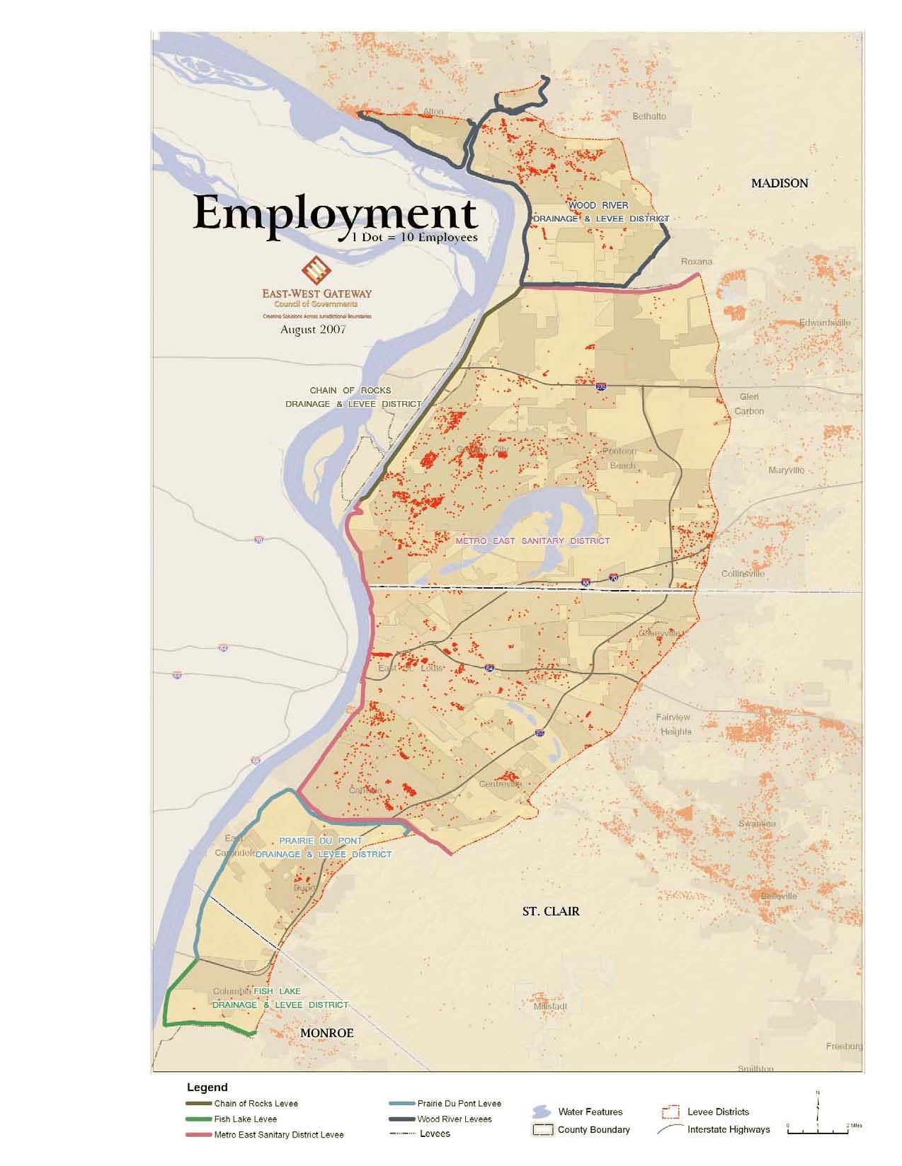
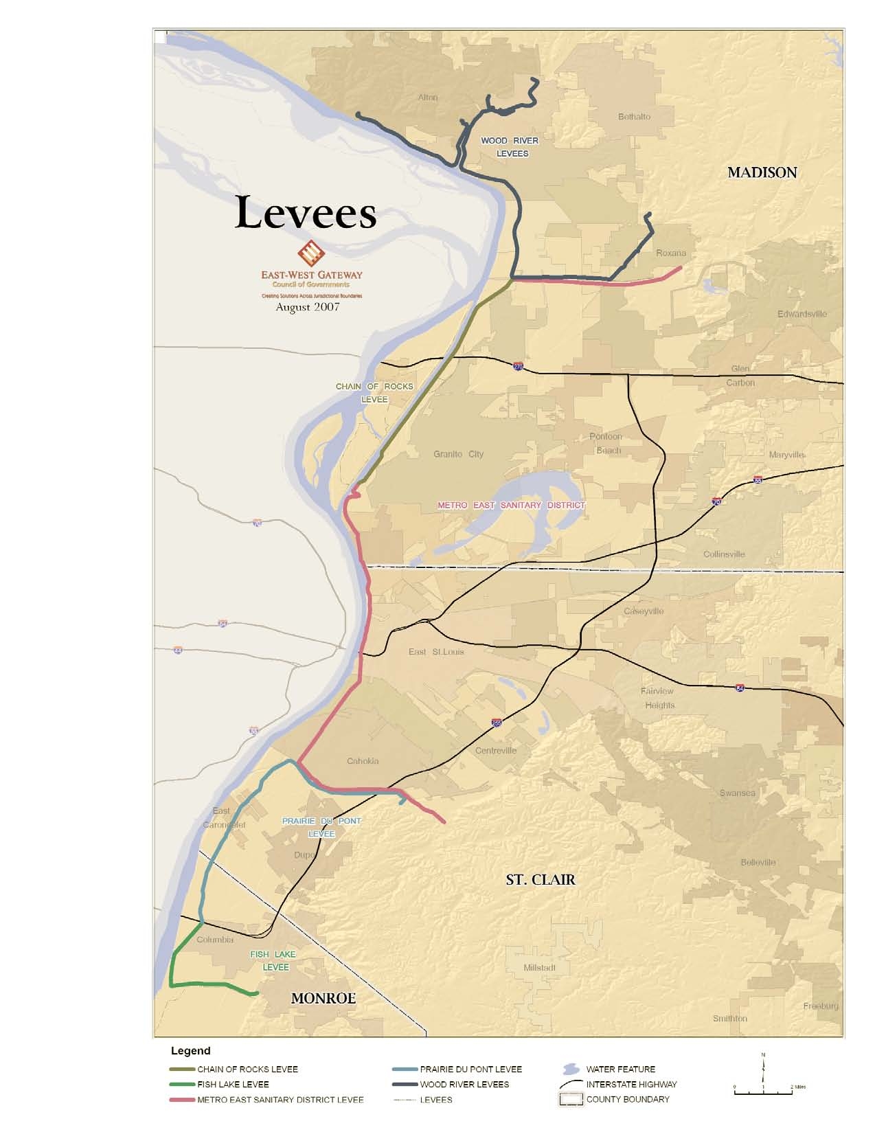
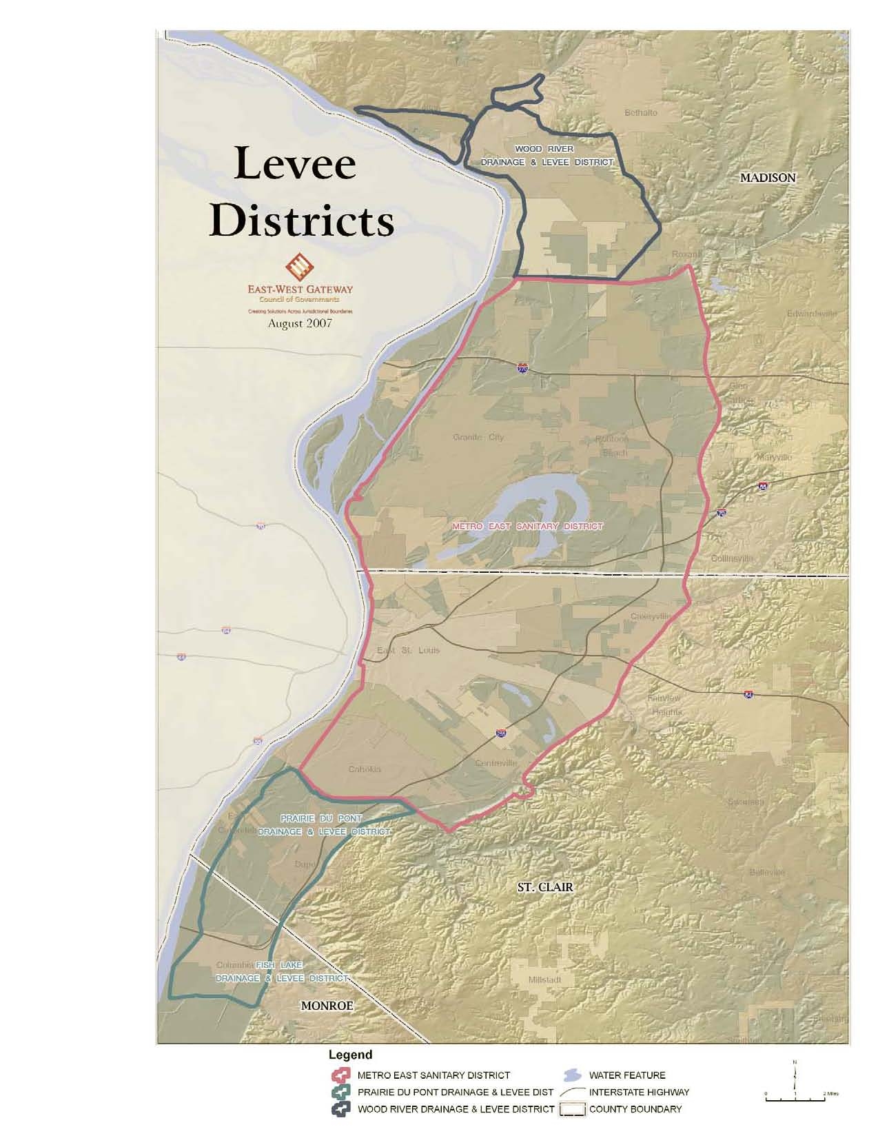
8. A September 29,2007, East West Gateway Council of Govermnents' briefing
document that summarizes the levees and flood control conditions in these communities is
attached as Exhibit
3. The briefing document notes (p. I) that, under Congressional
authorization and pursuant to federal regulations, FEMA is required to ascertain whether flood
hazard areas meet standards for adequate protection from catastrophic floods. The briefing
document includes maps and tables to illustrate the general scope
of the areas affected by the de-
accredited flood control facilities.
9. A November, 2007, Revised Draft of an East West Gateway Council of Govermnents'
status report concerning these levees and flood control conditions is attached as Exhibit
4. The
report notes (p. 35) that without an immediate response, the decertification
of levees will result
in large areas being designated as special flood hazard areas when preliminary maps are released
in early 2008, and that this is the same designation that would be used ifthere were no levees at
all in place and the area was completely unprotected from flooding. The report notes (p. 36) that
none
of the levee districts has made sufficient progress to avoid decertification and flood zone
designation in the final flood insurance maps to be issued in May 2009.
10. As shown in paragraphs 7 through 9 above, because the area where the proposed
North Milam landfill would be located would not be flood-proofed, according to FEMA and the
Corps, North Milam does not meet the requirements for siting criterion (iv). Further, because a
levee breach allowing floodwaters to reach the proposed landfill could affect communities in the
Metro East American Bottom floodplain, the public health, safety and welfare would not be
protected and, therefore, the proposed North Milam landfill does not meet siting criterion (ii).
3
Electronic Filing - Received, Clerk's Office, January 18, 2008
CONCLUSION
For the foregoing reasons, Petitioners request that the Board reconsider its December 6,
2007, Opinion and Order, reverse its ruling and find that Waste Management'sproposed North
Milam landfill does not meet the required siting criteria, and grant all relief it deems fair and just.
/s/ Bruce A. Morrison
Bruce
A. Morrison (II. Reg. No. 6279301)
Great Rivers Environmental Law Center
705 Olive Street, Suite 614
St. Louis, MO 63101-2208
Phone: (314) 231-4181
Fax: (314) 231-4184
Attorneys for petitioners
CERTIFICATE OF SERVICE
The undersigned certifies that on the 18th day of January, 2008, a complete copy
of the foregoing document was served upon counsel for respondents by electronic mail
and by enclosing the same in envelopes and depositing said envelopes, with first class
postage fully prepaid,
in a United States post office box, addressed to:
Donald
J. Moran
Pedersen
&
Houpt
161 North Clark Street
Suite 3100
Chicago, IL 60601-3224
Penni
S. Livingston
Livingston Law Firm
5701 Perrin Road
Fairview Heights, IL 62208
John
T. Papa
Callis, Papa, Hale, Szewczyk
&
Danzinger, PC
1326 Niedringhaus Avenue
Granite City, IL 62040
and upon
Carol Webb
Hearing Officer
Illinois Pollution Control Board
James
R. Thompson Center
100 West Randolph St., Suite 11-500
Chicago, Illinois 60601
/s/ Bruce
A. Morrison
4
Electronic Filing - Received, Clerk's Office, January 18, 2008
Cl RIG If\J l\ L
~eCEIVED
CLERK'S OFFICE
DEC 1 72007
SENDER
COMPLETE THIS SECTION
..
";11,-1
t;; 'JF ILLINOIS
',.,i1Ul'.
>i,
Control Board
••
• Is delivery address different
from
Item 1?
If YES, enter delivery address below:
x
A. Signature
B. Received
by
(PrInted Name)
01
e
So, .
3"E'COType
I1Ied Mall
D Express Mall
Reglstered
D
Return
Receipt for Merchandise
D Insured Mall
D C.O.D.
• Complete items 1, 2, and 3. Also complete
item
411
Restricted Delivery is desired.
• Print your name and address on the reVerse
so that we can return the card to you.
• Attach this card to the back of the mallpiece.
or on the front If space permits.
1. Artlcl.Addressedto:
12/6/07
B.M.
PCB
2007-084
Bruce A. Morrison
Great Rivers Environmental
Law Center
705
Olive Street
Suite
614
St. Louis, MO
63101-2208
4. Restricted
Delivery?
(Extra Fee)
D V.s
I
---------------'------'--'---'---'=----1
2. Article Number
I
_..;{1i_'"_n_Sfe-:'-:frDm..,..,.S<lI1I
__
fce_'_.be....;.V
_..;7..;;0..;;0..;;6..;..;;0..;;8..;;1..;;0..;..;;0.;;.0.;;.0..;4-:;;.2:;.2:;.2s~6.;.6.;.9;..8~
1
PS Form 3811, February 2004
DomestIc Retum Receipt
t02595-02.M.1540 1
I
Electronic Filing - Received, Clerk's Office, January 18, 2008
DEACCREDITATION NOTIFICATION LETTER
lMr./Ms.1 (Full Name
of Community official)
(Title
of Community Official)
(Address)
(City, State Abbreviation, and Zip Code)
Dear
[Mr./Ms.] (Last Name
of Community Official):
This letter is
in
regard to the levees shown on the effective Flood Insurance Rate Maps (FIRMs) and in
the effective Flood Insurance Study (FrS) reports for communities in Madison, St. Clair and Monroe
Counties in I!!inois. As you may know, the Department
of Homeland Security, Federal Emergency
Management Agency (FEMA), is in the process of producing new flood risk maps for the nation and, as
part of that effort, countywide FrS reports and Digital Flood Insurance Rate Maps (DFIRM) will be
issued for Madison, St. Clair, and Monroe Counties.
As part
ofFEMA's effort to produce the DFIRM, it was determined that the flood hazard information
presented on the effective FIRM and in the effective Frs report is based, in some areas, on flood
protection provided by at least one
of five levee systems
in
the Metro East area that include the following:
Wood River Drainage
&
Levee District
Chain of Rocks Levee
Metro East Sanitary District
Prairie Du Pont Levee
&
Sanitary District
Fish Lake Drainage
&
Levee District
Based on the information available and on the mapping standards
of the National Flood Insurance
Program (NFIP) at the time the FrS was performed, FEMA accredited these levee with providing
protection from the flood that has a l-percent-chance of being equaled or exceeded in any given year.
The l-percent-annual-chance flood also is referred to as the base flood.
Recently, FEMA was informed by the U.S. Army Corps
of Engineers (USACE) that they have
determined the levees identified above do not meet the requirements set forth in the Code
of Federal
Regulations, Title 44, Section 65.10 (44 CFR 65.10), entitled "Mapping of Areas Protected by Levee
Systems". Since the levees and levee systems identified above do not meet the requirements set forth in
44 CFR 65.10, they will be de-accredited and therefore will not be shown on the future DFIRM as
providing protection from the base flood.
You were invited to a meeting hosted by the East West Gateway Council
of Governments and
Congressman Jerry Costello that was held on August 29, 2007 to discuss the status ofthe levees and
FEMA'sde-accreditation process. The area landward of the levee will be mapped as a Special Flood
Hazard Area (SFHA) on the DFIRM when it is prepared. Therefore, federally regulated lenders will
require the purchase of flood insurance on loans secured by structures located in the de-accredited area
when the DFIRM becomes effective. In addition, continued participation in the NFIP will require your
community to adopt and enforce local floodplain management regulations in these areas.
It
is highly
recommended that you consider this risk in your local emergency management plans, including creating
evacuation plans for this area.
Please note, there is a provision in the NFIP regulations that may be used in unique situations to allow
FEMA to map the areas previously shown as being protected
by the levee (accredited) as a "Restoration"
Zone (Zone AR). Initial information provided to us by the USACE indicates that these levees
may
meet
the requirements for Zone AR designation. In order to be considered, the Chief Elected Official must
....
I
PLAINTIFF'S
EXHIBIT
2.
Electronic Filing - Received, Clerk's Office, January 18, 2008
provide a written request to FEMA for the restoration zone designation. There are specific submittal
requirements that must be included with the request. Attached are several documents that may help you
decide
if you want to pursue the Zone AR designation. In order to be considered for a Zone AR
designation when the preliminary map is distributed, your official request package must be received by
this office by January 30, 2008.
FEMA will issue Preliminary Maps when the de-accredited mapping is completed. At that time, FEMA
will conduct a Flood Risk Information Open House and will meet with local officials and the public
regarding the revised maps. Following this meeting, a 90-day Appeal/Protest Period will be held. When
all Appeals/Protests are resolved, FEMA will issue the Letter
of Final Determination. Final DFIRMs will
be distributed that will become effective 6 months after the date of the Letter of Final Determination.
We encourage you to inform property owners behind the levee of this change. FEMA has produced a
variety of outreach materials which can be used to educate and inform the public about the risks
associated with levees and how they can better protect themselves against those risks. These materials are
located online at: http://www.fema.gov/plan/preventlfum/lv intro.shtm.
If you need additional information or assistance, please contact Ms. Terry Reuss Fell, Chief of the
Floodplain Management
&
Insurance Branch, by email at www.terrv.fell@dhs.gov or by phone at 312-
408-5587.
Sincerely,
Mr. Norbert F. Schwartz, Director
Mitigation Division
FEMA Region V
Enclosures:
44 CFR Section 65.10: "Mapping
of Areas Protected by Levee Systems
Submittal Requirements for Restoration Zone (Zone AR) - (2 pages)
Flood Control Restoration Zone Requirements (4 pages)
AR Zone 44 CFR Section 65.14, part 60.3(f), and definition of "developed area"
cc: Levee
Owners
(Commnnity Floodplain Administrator)
Paul Osman, IL DNR/ NFIP State Coordinator
Mr. Les Sterman, EW Gateway Council
of Governments
Colonel Lewis Setliff, USACE, St. Louis District
Senator Richard Durbin
Senator Barack Obama
Congressman Jerry Costello
Congressman John Shimkus
Electronic Filing - Received, Clerk's Office, January 18, 2008
Mississippi River
Levee Issues in
Illinois
Briefing for
Elected Officials
September 29, 2007
Electronic Filing - Received, Clerk's Office, January 18, 2008
Levee and Flood Control Condition in Southwestern Illinois
An Issue of Public Safety and Economic Growth
Summary
Under Congressional authorization, the Federal Emergency Management Agency (FEMA) is
revising all flood risk maps for base flood levels - the 100 year flood -- or a flood with a 1%
chance of occurring in any given year - under a new federal regulation 44 CFR 65.10. The new
federal regulation requires FEMA to ascertain whether flood hazard areas meet standards for
adequate protection from catastrophic floods. Maps for the Metro East will be completed some-
time in the next couple of months. These new maps are based on engineering evaluations of lev-
ees and other flood control facilities done by the Corps of Engineers. Following the completion of
the maps, there will be a series of public meetings. It will take about a year before the maps are
finalized.
According to FEMA and the Corps of Engineers, five levees in the Metro East are at risk of failing
due to structural deficiencies in the levees. These levees extend from Wood River south to
Prairie Du Pont and Fish Lake. Most of the American Bottoms from the Mississippi River to Bluff
Road is at risk.
While the first concern is public safety and the increased risk of catastrophic flooding, there are
significant economic consequences that will cloud future economic growth in a large area of
southwestern Illinois. The map revision will determine which homes and businesses will be
potentially subject to flooding and therefore required to buy costly flood insurance. The probabili-
ty of levee decertification will cause massive costs to existing individuals and businesses and
cripple economic growth and investment in our region. Federally regulated financial institutions
may not be able to issue loans to homeowners or businesses that don't carry adequate flood
insurance, and communities will need to adopt development ordinances that include strict require-
ments for building in flood zones. Many homeowners may not be able to afford flood insurance,
even at the current favorable rate, putting them at future financial risk.
This potential action will affect almost a third of the population of the Illinois portion of the St.
Louis area and many critical businesses that are the foundation of our local economy. The con-
sequences will be felt not only by areas that could be in jeopardy of flooding, but also by all com-
munities that have a stake in the economic vitality of our region.
Four thousand business establishments face heightened risk due to deficiencies in the levees. In
the 2000 Census, of the 59,107 occupied housing units in the affected area, 38,441 (65%) were
owner-occupied, and 20,666 were rental units. Of all owner-occupied units, 43% do not have a
mortgage. These units would be exempt from the federal mandate to purchase flood insurance,
but they would all benefit from having insurance in case of a disastrous flood.
1
Electronic Filing - Received, Clerk's Office, January 18, 2008
Levee Improvement
This region represents the second largest concentration of population in the Mississippi Corridor
(after New Orleans) and a collaborative effort should be successful in obtaining the funds neces-
sary to improve the levees.
The Corps of Engineers describe their goal as to "Assess, Communicate Risk, and Solve" the
problem. Their risk analysis looked at design height and under-seepage problems. It is the under-
seepage, plus old pumps and drainage tiles (Wood River Levee built 1938) that led the Corps to
determine the levees are not adequate and need repair to be certified. The Corps of Engineers is
still working to define actual costs to improve the levees, but costs could range from $50 -100 mil-
lion. Current policy of the federal government is that all Corps projects require a 35 percent local
match.
Flood Insurance
FEMA in Region V, Chicago, is focused on the importance of flood insurance as a means of man-
aging that risk and advised that flood insurance will soon be mandatory. When the FEMA maps
are finalized (a year to a 18 months from now), property in flood risk areas will be required to have
federal flood insurance if it has a mortgage from a federally regulated institution. Because the
property is still officially behind a protected levee, flood insurance purchased now (and over the
next year before map finalization) is significantly less expensive than it will be once the maps are
finalized. FEMA rules also allow for the 'grandfathering' of insurance rates, so that people who
buy insurance before the new maps are final will be able to continue to hold the insurance at a
significantly reduced rate, while new rates will be expected to rise 400 percent (or more) since the
land will be considered not protected.
The maps and tables on the following pages illustrate the general scope of the areas directly
affected by the flood control facilities in question, and are designed to communicate the population
and employment concentrations that will be directly affected by the impending flood map revisions.
In the coming months, FEMA will be holding public meetings to discuss and provide information
about the new maps, and will allow communities to review the details and, where justified, to chal-
lenge the contents.
2
Electronic Filing - Received, Clerk's Office, January 18, 2008
Persons
Households
Jobs
Alorton
2,749
886
122
Alton
55
36
536
Brooklyn
676
267
82
Cahokia
16,391
5,693
4,655
Caseyville
2,928
1,146
723
Centreville
5,885
2,095
908
Collinsville
695
312
1,844
Columbia
10
5
198
Dupo
3,681
1,462
719
East Alton
5,767
2,522
4,482
East Carondelet
203
77
3
East St. Louis
31,155
11,035
7,383
Edwardsville
65
26
12
Fairmont City
2,436
871
228
Glen Carbon
42
14
122
Granite City
31,301
12,773
15,123
Hartford
1,545
650
432
Madison
4,545
1,881
1,589
Pontoon Beach
5,620
2,134
980
Roxana
1,516
644
542
Sauget
249
101
1,756
South Roxana
1,888
707
388
Venice
2,528
950
252
Washington Park
5,345
1,692
538
Wood River
11,234
4,704
5,385
Sources: US Census, 2000
Longitudinal Employer Household Dynamics, 2004 estimates
Information about Potentially Affected Communities
Potentially Affected Population, by County
Persons
Households
Jobs
Madison
78,981
32,055
33,241
Monroe
70
32
250
St. Clair
77,230
27,02”
18,048
Total
156,281
59,107
51,539
Sources: US Census, 2000
Longitudinal Employer-Household Dynamics
Potentially Affected Population, by Municipality
3
Electronic Filing - Received, Clerk's Office, January 18, 2008
Information about Potentially Affected Communities
(continued)
62040
1,566
62048
75
62060
190
62084
79
62090
41
62095
477
62201
526
62203
209
62204
163
62205
309
62206
503
62207
251
62240
42
Additional employers are
located in the following
ZIP codes: 62002,
62024, 62232, 62234.
Source: ReferenceUSA
Population Households
Jobs
Wood River
24,723
10,272
13,613
Metro East
126,628
46,773
37,258
Prarie DuPont and Fish Lake
5,330
2,062
668
Sources: US Census, 2000
Longitudinal Employer-Household Dynamics
Potentially Affected
Businesses, by ZIP Code
Potentially Affected Population, by Levee District
4
Electronic Filing - Received, Clerk's Office, January 18, 2008
Information about Potentially Affected Communities
(continued)
Cerro Flow Products
Sauget
Conoco Refinery
Wood River
Gateway Regional Medical Center
Granite City
Granite City Steel
Granite City
Kenneth Hall Regional Hospital
East St. Louis
Kraft Foods
Granite City
Midcoast Aviation
Cahokia
Olin Corporation
East Alton
Solutia
Sauget
Southwestern Illinois Correctional Center
East St. Louis
Touchette Regional Hospital
East St. Louis
Tower Automotive
Granite City
Source: Public Policy Research Center/ReferenceUSA
Some Potentially Affected Major Employers
5
Electronic Filing - Received, Clerk's Office, January 18, 2008
F '"
E<'h.>l""''''
MADISON
"'.
••
,"""
\ CofT><:tI
. .i
.~
/
\
,
\
.',r -/
Ro
ai,"
,I
,,'
.
.;:;~
.
;:;-~
.
.
"".
,;,>.
~
.'
Beth II'
"
'''''.-~'-'\
"',,W
'CC~,
\
.~~-
""".
~~
RIVER
:'~;"\
LEVEE Dl8TRIG;r
~W
'
ST. CL\IR
=,"",
=",11>-- i:<l;,
'""",
,tt,
METRO EAST SANITARY Dl&mlCT
DISffilCT
MONROE
August 200i
DRAINAGE
1\
LEVEE
-----
.'
'"
P°.R!!.~,il!!on
EAsT.WESTGATEWAY
_
..
~
-
/
Legend
_Chl,n of Rocks Lev..
_
FWiloko
lev~
_Pr.,,;. Du Pont Ltv..
_
Wood
R",~'
L~V~M
--- Levees
Population
, ,_ 1 D<>1_10P""pift
.. ';\1;11"" Features
o
County Bouroclary
r.'J
lllYM [);81,iets
~
Inlef$late Highways
Electronic Filing - Received, Clerk's Office, January 18, 2008
MADISON
,..
C<>llr,,::.,
G~
., CoUI","
..
,\
",
/
:1
•
Be
JII~
•
••
" '.
"
,
\
ST. ClAIR
'
..
. ...
'"..',:,'
1.'-'>,
-....
'.' .'"
'.~;.f'
".
.:~
•...
-_._-\
",.~r;
.
-
...
_
..•.
\~"::'~
...'
,,"
-
'.;;;"
.
\
~
. ,"
'.
.,
.-,
'Wooo RIVER
"
INAG?! & lEVEE DISTRK.;r
METRO EAST SANITARY DlGmlCT
"~
>
'.
..
..
:"-$
It .',
•.
CWlIN OF ROCKS
j~";:".:.
::;~
..
~,'",~,~<:"'_~C~''';'''--T
--\
DRAINAGE
&
LEVEE DISTRICTI
• I.•• ,
'--,
I;
/
..
.:;i'P.
"1,"
'"\_
V
~:'J
::,.
(~
......
:~A:.:;~
..... ':'.
;
>
_.,r
...
",".'....:""
..",
,
,...: ..••
~
:;->
,,'..
,
;,
.,,"':....
'>~'\"
..
.
:.~
....
~~
..
.-
;.....
:.';~
,..;::-..r
-
..
~-.,
.:': "-t
..1'......... ;.'"
,
~
••• :..',::.'>.
Allgll~l
2007
e-
_
',-
• PRAIRIE 00 PONT __--
/
r
.
,,~
'OOAINAGE
&
l~EE
DISTRICT
.';/
.
'.
'j/
. ..
.>
~
/
.'!'" /
f/
'"
Emploxm~,!!!
EAST-WEST
_
~
..-
GATEWAY
"I"
..
FISH
I
l.AIlE
'tlfto..INAGEo
i.
LEVEE DlSffilCT
'i
MONROE
., ,
Legend
_Chain of Roc,," L.v..
_Fi""L3k~l."
...
_Pl",n" DU Pont Llv..
_
Wood
R,v~,
L""~",,
--- Levees
., Wale<
Features
C..:J
County Boundal)'
t.J
levee
Districts
,,-----
Intcr:;t~tc Hillhw~ys
Electronic Filing - Received, Clerk's Office, January 18, 2008
Maryl '
Sminlto"
,
MADISON
METRO EAST SNlrTARY DISTRICT
',"
-~
.._----------...--=_=--=-=--
•.
_--~--_.
)
CHI\IN OF ROCKS
~~,
ST. CLAIR
Al)g"~1
200i
EAST-WEST GATEWAY
~.-
-----
Levees
~
---
L---...
_,.:.,.~"''',,,,,
MONROE
~"'"
'\
l
Legend
_CHAIN OF ROCKS LEVEE
_FlSHLAKELEVEE
_METRO E.•
,,~T
SANITARY DISTRICT LEVEE
_
PRAIRIE ou rONT LEVEE
_WOOD RIVER LEVEES
---- LEVEES
... WATER FEATURE
,..,.- INTER&TATE HIGHINAY
L.:...
J COUNTY BOUNDARY
Electronic Filing - Received, Clerk's Office, January 18, 2008
Districts
METRO EAST SANITARY DISTRICT
.. WATER FEATURE
PRAIRIE DU PONT DRAINAGE & LEVEE D1ST ",.--- INTERSTATE HIGHWAY
WOOD RIVER DRAINAGE & LEVEE DISTRICT
C.J
COUNTY BOUNDARY
Legend
I
J'ugusl200i
EAST_WEST
~----
---
GATEWAY
Levee
,.
Electronic Filing - Received, Clerk's Office, January 18, 2008
Southwestern Illinois
Flood Prevention
Initiative
Status Report &
Project Timeline
November, 2007
REVISED
DRAFT
Electronic Filing - Received, Clerk's Office, January 18, 2008
ii
Table of Contents
Executive Summary ................................................................................................................. iv
I. Introduction..........................................................................................................................1
II. Background..........................................................................................................................3
A. Flood Risk and Insurance ..............................................................................................3
B. The Levee System .........................................................................................................8
C. Levee and Drainage Districts ......................................................................................10
Wood River Drainage and Levee District ...................................................................10
Metro East Sanitary District ........................................................................................13
Prairie Du Pont Levee and Sanitary District ...............................................................16
Fish Lake Levee District .............................................................................................16
III. Flood Maps and Flood Insurance ......................................................................................18
A. FEMA Mapping Process...............................................................................................18
B. Restoration Zone (AR Zone) Designation ...................................................................19
C. Benefits of AR Zone ....................................................................................................20
D. Zone A99.....................................................................................................................21
IV. Current Status of Deficient Illinois Levees .......................................................................22
Wood River Drainage and Levee District..........................................................................22
Chain of Rocks ..................................................................................................................25
Metro East Sanitary District .............................................................................................26
Prairie Du Pont and Fish Lake Districts ............................................................................27
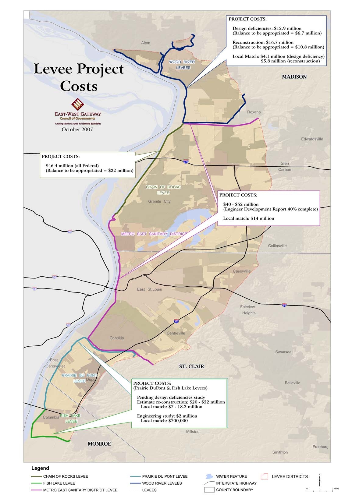
V. Project Costs and Schedule...............................................................................................29
VI. Next Steps – A Path to Rebuilding ...................................................................................35
A. Creation of a Leadership Task Force...........................................................................35
B. Immediate Application for “AR Zone” Protected Status.............................................35
C. Development of a Ten-Year Plan to Restore the Flood Protection System.................36
D. Secure Expert Assistance in Financing and Engineering ............................................36
E. Community Engagement..............................................................................................36
F. Secure Funding for Immediate Activities.....................................................................37
Appendices
Appendix A: River Stages .................................................................................................38
Appendix B: FEMA Notification Letter and AR Zone Submittal Requirements.............40
Appendix C: FEMA Progress of Mapping Activities Nationwide ....................................44
Appendix D: Glossary .......................................................................................................49
Electronic Filing - Received, Clerk's Office, January 18, 2008
iii
List of Figures
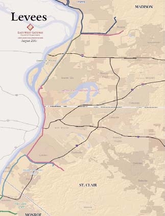
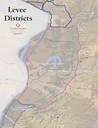
Figure 1: Levee Districts............................................................................................................5
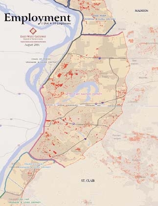
Figure 2: Population...................................................................................................................6
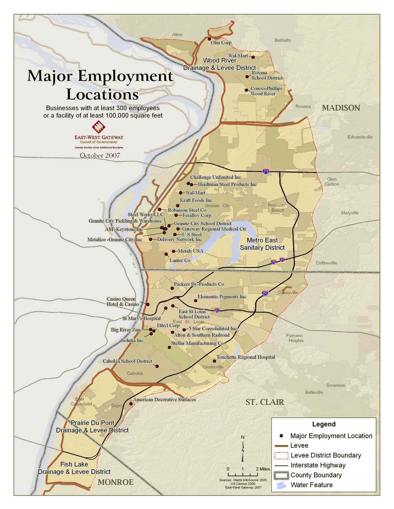
Figure 3: Major Employment Locations....................................................................................7
Figure 4: Cross-Sectional View of an Earthen Levee................................................................8
Figure 5: Schematic of Standard Levee System ........................................................................9
Figure 6: Potential Levee Failure Scenarios ............................................................................10
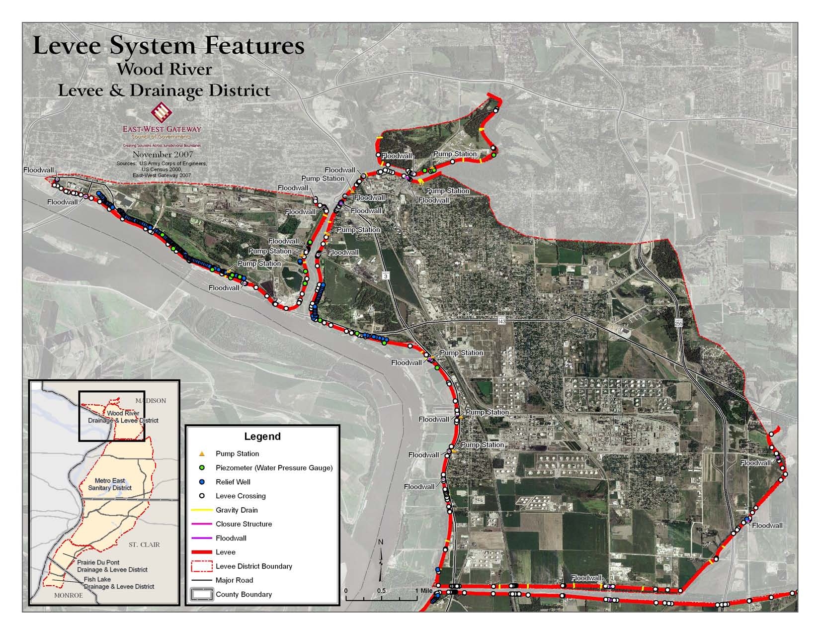
Figure 7: Levee System Features: Wood River .......................................................................12
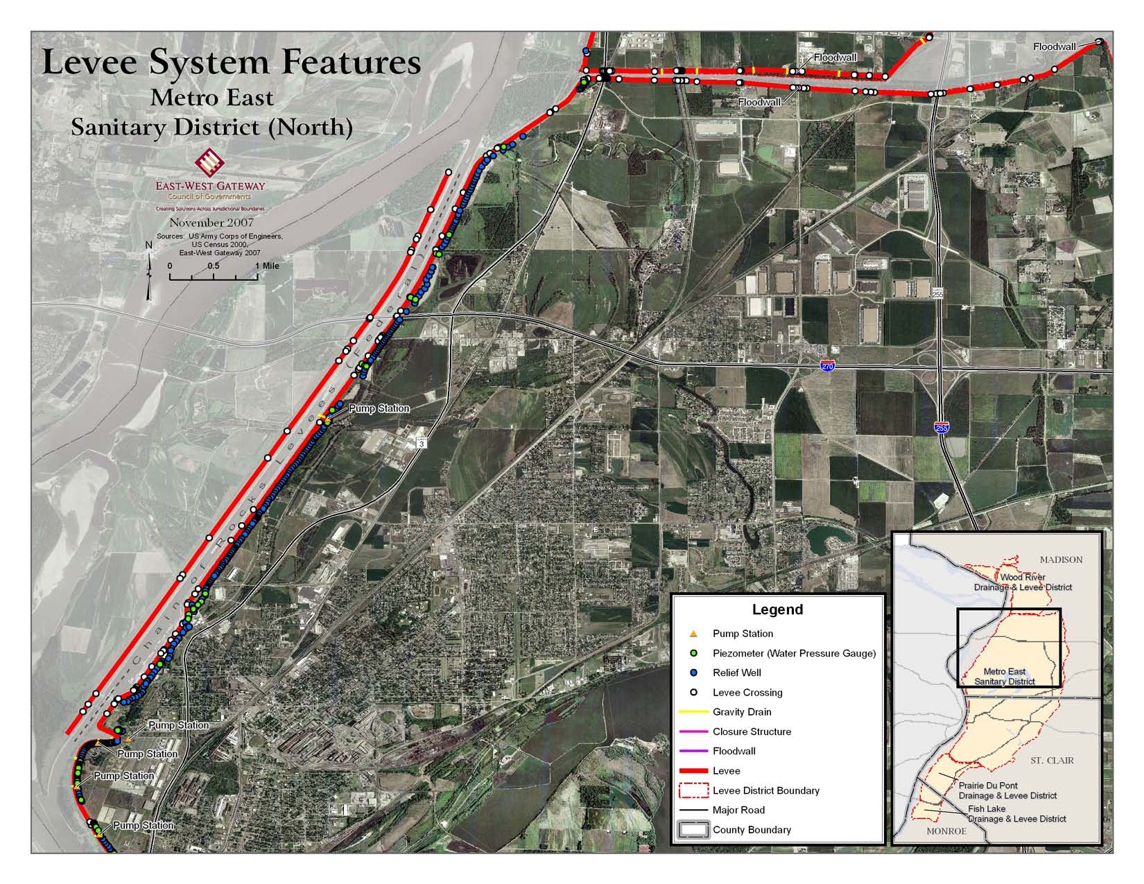
Figure 8: Levee System Features: Metro East (North) ............................................................14
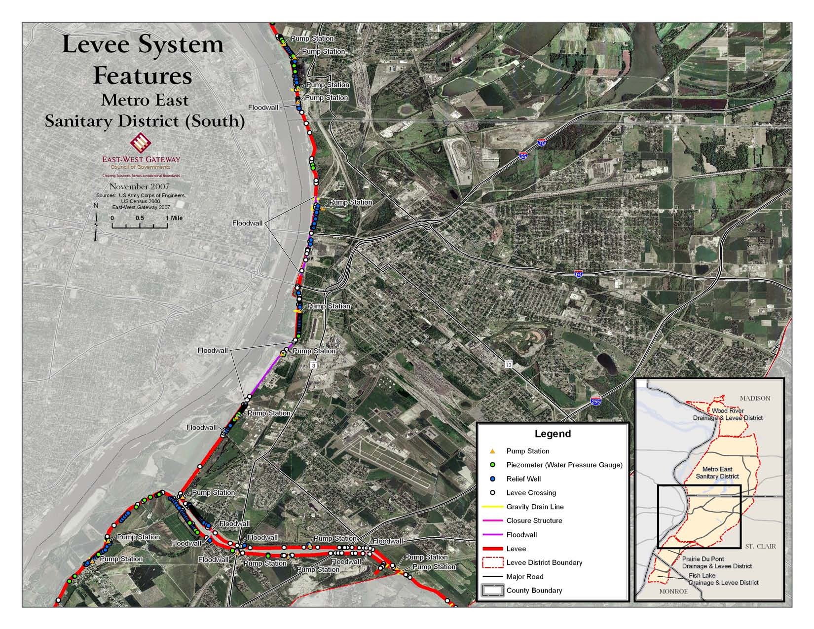
Figure 9: Levee System Features, Metro East (South) ............................................................15
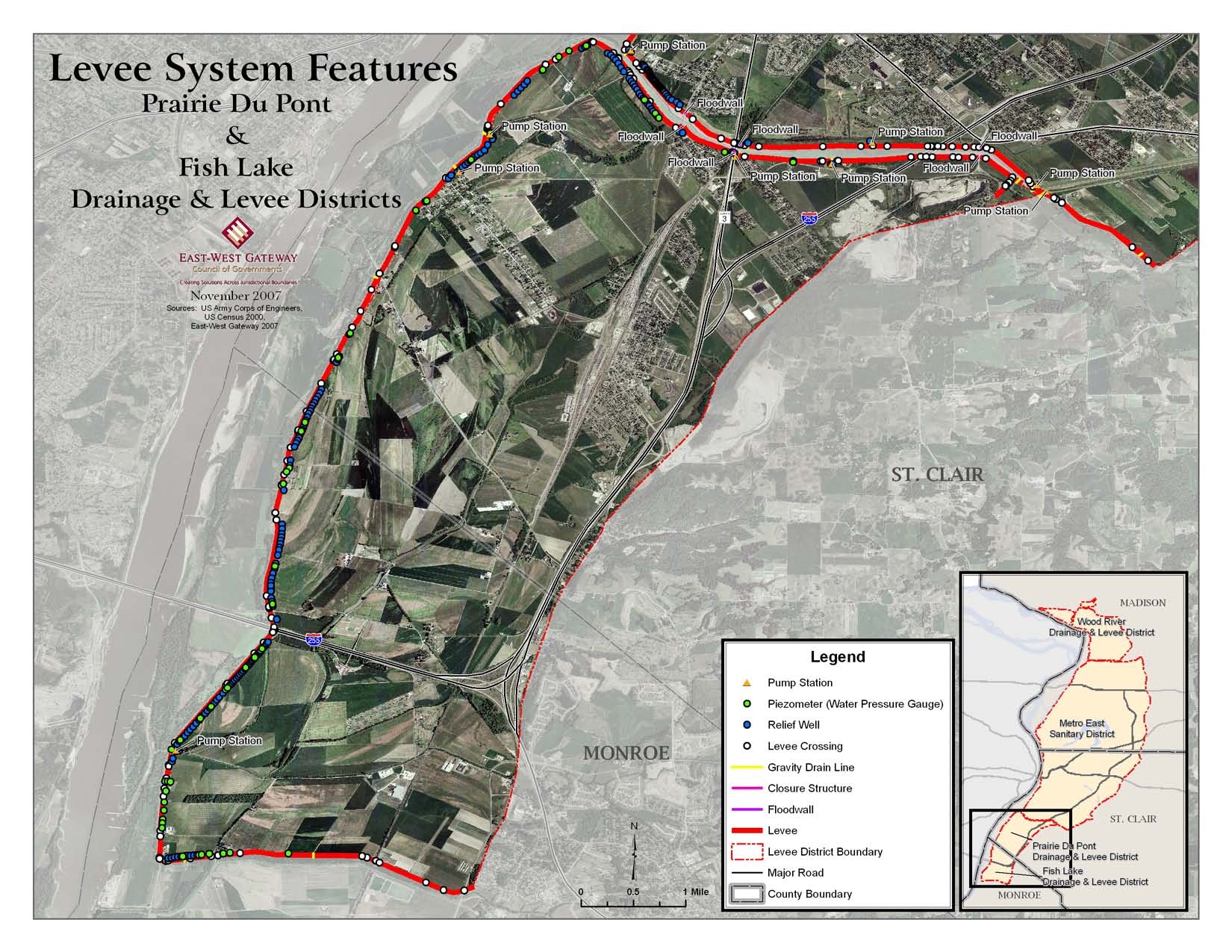
Figure 10: Levee System Features: Prairie Du Pont and Fish Lake ........................................17
Figure 11: Levee Project Cost............................................................................................33
List of Tables
Table 1: Demographics of Area Directly Affected....................................................................4
Table 2a: Deficiencies in the Wood River Drainage and Levee District - Upper....................23
Table 2b: Deficiencies in Wood River Drainage and Levee District – Lower ........................24
Table 2c: Deficiencies in Wood River Drainage and Levee District – East &West Forks .....24
Table 3: Deficiencies in Chain of Rocks Canal East Levee ....................................................26
Table 4: Deficiencies in Metro East Sanitary District .............................................................26
Table 5a: Deficiencies in Prairie Du Pont Levee and Sanitary District...................................27
Table 5b: Deficiencies in Fish Lake Drainage and Levee District ..........................................28
Table 6: Summary of Estimated Project Costs and Status of Funding ....................................30
Table 7: Fiscal Capacity of Levee Districts .............................................................................31
Table 8: Corps of Engineers Levee Project Phases..................................................................32
Electronic Filing - Received, Clerk's Office, January 18, 2008
iv
Executive Summary
•
Without immediate large scale coordinated effort, nearly all of the American Bottoms
will be declared to be a flood hazard area on preliminary FEMA maps as early as
March 2008.
•
The issue presents substantial public safety and economic consequences for
Southwestern Illinois.
Flood insurance rates will increase substantially when the preliminary maps
become final, currently predicted to occur in early to mid 2009.
Uncertainty about risk and development constraints will discourage business
investment.
•
The total cost to repair the five levee systems in Madison, St. Clair and Monroe
counties is estimated to be between $136 and $180 million.
•
Local match (of 35%) required for the four locally owned levee systems is estimated
to be between $31 and $47 million.
•
Because of the historically slow rate of appropriations for federal funding, area
leaders should consider raising the entire amount needed to begin repairs as soon as
possible, with a goal of completing the entire group of projects in ten years or less.
•
A coordinated regional strategy is the most effective way to address the flood control
system in Southwestern Illinois because:
The five levee systems are inextricably linked hydrologically.
Two of the levee systems cross county boundaries and all of them pass through
numerous cities and towns.
Collaboration among a broad number of varied constituencies will strengthen the
effort.
The citizens and economy of the entire region of Southwestern Illinois are
affected.
•
By January 30, 2008, application should be made to FEMA for a “Restoration Zone”
status, or AR Zone, for the entire American Bottoms area, because it will preserve
lower flood insurance rates for residents and allow a 10-year period to carry out a
plan for repair and restoration of the levees.
•
Other recommended action steps include creating a leadership task force, developing
a ten year plan to restore the levees (including financial and construction
components), securing expert assistance in finance and engineering, launching a
comprehensive community engagement strategy to reach residents and the business
community, and securing funding to carry out the entire planning strategy.
Electronic Filing - Received, Clerk's Office, January 18, 2008
1
I. Introduction
The 1993 Midwest flood was one of the most damaging natural disasters ever to affect the
United States up to that time. Total impact of damages approximated $15 billion, thousands of
people were evacuated, fifty people died and hundreds of levees failed. The flood and its path of
devastation lasted for several months. The magnitude of this flood event seemed overwhelming.
Just twelve years later Hurricane Katrina and storm surges that followed caused more than fifty
levee breaches, resulting in catastrophic flooding damage over large portions of southern
Mississippi and Louisiana. More than fourteen hundred people died and over 80% of New
Orleans was flooded. The losses devastated an entire multistate region and, for a time, adversely
affected the whole United States economy.
Katrina has focused great attention on the flood protection systems across the United States.
Under the current circumstances, competition for limited federal funding, limited financial
capacity of local sponsors and delays in appropriations conspire to compromise public safety and
welfare.
Congressman Jerry Costello convened an Illinois Levee Summit on August 15, 2007 onboard the
U. S. Army Corps of Engineers Motor Vessel Mississippi for the purpose of providing an
overview of the levee systems in the St. Louis region and describing levee deficiencies and flood
risks for five levees systems in the Illinois area of the region. Officials representing the Federal
Emergency Management Agency (FEMA) Region V explained how the congressionally
mandated revision of all flood risk maps for the base level “100-year flood” would affect levee
status in Southwestern Illinois. Based on current information provided by the U.S. Army Corps
of Engineers (Corps), the five affected levee systems will not meet the minimum criteria for
flood protection. These levee systems along the Mississippi River extend from the Wood River
Drainage and Levee District in the north, to Prairie Du Pont and Fish Lake Levee Districts in the
south. According to reports and studies done by the Corps, all the levees in question exhibit
significant underseepage problems that, if left uncorrected, significantly increase the risk of a
major flood.
Since the FEMA announcement concerning levee decertification, elected officials in St. Clair,
Madison and Monroe counties in Illinois requested that the East-West Gateway Council of
Governments follow up on recent discussions and fact-finding meetings to provide an accurate,
up-to-date status report that would both define the problem and suggest a process for correcting
the levee deficiencies. They indicated that they would like to take a regional approach to address
this problem.
The purpose of this report is to present the facts currently known about the levee projects to
determine what has to be accomplished to repair the levees to the point that they can be certified
by the Corps to protect from a 100-year flood. Expediting the schedule for planning and
reconstruction is of paramount importance because the flood risks and rising cost of flood
insurance undermine public safety and the economic vitality of large parts of Southwestern
Illinois located in Madison, St. Clair and Monroe counties. While the flood risks and map
Electronic Filing - Received, Clerk's Office, January 18, 2008
2
revisions directly affect the three counties and their respective communities, neighboring
communities throughout the St. Louis region are also affected.
The report contains information about the FEMA remapping process and the role of national
flood insurance, a status report on all of the projects, including projected costs, funding
availability and estimated times for completion, and financial and organizational information
about each of the levee districts. The report concludes with recommendations for a series of
actions to be completed within the next two months that will begin a measured and urgent
process to restore the flood control system in Southwestern Illinois to provide the protection for
which they were designed. Actions are also outlined that will provide a measure of economic
assurance for the area during the period that full flood protection is being restored. Quick
agreement on action steps will facilitate a rapid reconstruction effort.
Electronic Filing - Received, Clerk's Office, January 18, 2008
3
II. Background
Under Congressional authorization, FEMA is digitizing its flood insurance maps nationwide over
approximately a five-year period. As part of the process of producing new maps, FEMA is
revising all flood risk maps for base flood levels, a flood with a 1% chance of occurring in any
given year – the 100-year flood. Federal regulations require FEMA to ascertain whether flood
hazard areas meet standards for adequate protection from catastrophic floods. As part of the
mapping process, FEMA has asked the Corps to evaluate and certify levees and other flood
control facilities using specific FEMA standards. Under the current schedule for FEMA Region
V, maps for the metro east area of the St. Louis region will be completed in March 2008. FEMA
will release the maps in draft format and then conduct a series of public meetings. There follows
a 90-day appeal period. FEMA will review and respond to the appeals before the maps are
finalized. The entire process, from the release of preliminary maps through meetings and
appeals to map finalization, should take about a year.
According to FEMA and the Corps, five Illinois levee systems in the St. Louis area are at risk of
failing due to structural deficiencies. The levees are: Wood River, Chain of Rocks, Metro East,
Prairie Du Pont, and Fish Lake. Most of the American Bottoms, from the Mississippi River east
to Bluff Road, which is currently designated as a protected area, is at risk (Figure 1).
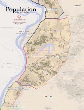
After New Orleans, the American Bottoms region represents the second largest concentration of
population in the Mississippi Corridor. More than 150,000 residents and 50,000 jobs are in this
area (Figures 2 and 3) which has been considered a protected zone, but which may now be
reclassified as an area subject to flood risk. While the first concern is public safety and the
recognition of increased risk of catastrophic flooding, there are significant economic
consequences that will affect the future economic health of Southwestern Illinois.
A. Flood Risk and Insurance
When the FEMA maps are finalized (currently predicted to occur in March 2009), property in
flood risk areas will be required to have federal flood insurance to qualify for a mortgage from a
federally regulated institution. Flood insurance purchased now (and over the next year before
the new maps are officially adopted by FEMA) is significantly less expensive than it will be once
the maps are finalized, because the property is still officially behind a protected levee.
Four thousand business establishments face heightened risk due to deficiencies in the levees.
According to the 2000 Census, of the 59,107 occupied housing units in the affected area, 38,441
(65%) were owner-occupied and 20,666 were rental units
1
. Forty-three percent of all owner-
occupied homes do not have a mortgage. These homes are exempt from the federal mandate to
purchase flood insurance, but homeowners will nonetheless benefit from having insurance in
case of a disastrous flood. Moreover, these homes could not be sold to a new owner requiring a
1
A small proportion of these households are already included in special flood hazard areas because of proximity to
small stream or tributaries of the Mississippi River that are subject to flooding.
Electronic Filing - Received, Clerk's Office, January 18, 2008
4
mortgage without the new owner purchasing insurance at a significantly higher rate.
2
FEMA
urges all residents living behind levees to purchase insurance whether it is required or not.
Table 1
Demographics of Area Directly Affected
County
Population
Households
Jobs
Madison
78,981
32,055
33,241
St. Clair
77,230
27,020
18,048
Monroe
70
32
250
15,6281
59,107
51,539
Levee decertification will cause massive costs to individuals and businesses and potentially
cripple economic growth and investment in the region. Federally regulated financial institutions
will not be able to issue loans to homeowners or businesses that do not carry adequate flood
insurance, and communities will need to adopt development ordinances that include strict
requirements for building in flood zones. Many homeowners will not be able to afford flood
insurance, even at the current favorable rate, putting them at future financial risk. A secondary
impact to homeowners and small businesses is a potential decline in property values, since sales
of property that require bank financing will be conditioned on the purchase of costly flood
insurance.
This potential action will directly affect almost a third of the population of the Illinois portion of
the St. Louis area and many critical businesses that are the foundation of the local economy.
Inadequate levees threaten to disrupt all who travel on interstate highways 55, 64 and 70 through
the American Bottoms. The consequences will be felt not only by areas that could be in jeopardy
of flooding, but also by all communities that have a stake in the economic vitality of the region.
2
When a levee is decertified, FEMA rules allow for a grandfathering of lower insurance rates for those who
purchased insurance before decertification; such rates are also available to the purchaser of a home that has been
continually insured.
Electronic Filing - Received, Clerk's Office, January 18, 2008
MaryviliEf
,
i
2Mln
'--~-'-~---',
MADISON
Smithl n
Collinsville
Belhalto
WATER FEATURE
~
INTERSTATE HIGHWAY
L.=-J COUNTY BOUNDARY
WOOD RIVER
I!.EVEES
--------
,..<
•
..?
Millstadt
.
~
ST. CLAIR
METRO EAST SANITARY DISTRIC\
Granite City
Anon
East
St.LOU'~i:S---;----~~:-...)L_
.....
-
PRAIRIE DU PONT LEVEE
-WOOD RIVER LEVEES
_
..._ .. LEVEES
j)
Cahokia
MONROE
I
!
\
EAsT.WEST GATEWAY
t-.oSoU:CN
CoundlofGOWl •• ,....
_
rt:s
August 2007
Levees
':'
-
CHAIN OF ROCKS LEVEE
-
FISH LAKE LEVEE
_
METRO EAST
SANITARY DISTRICT LEVEE
Legend
/
I
I
Electronic Filing - Received, Clerk's Office, January 18, 2008
TOIalllopulal;on "ffeeled: 156.281
MADISON
.,
.;
I
"
',It
".~
''''';
.'
I '.
, ' .
.-.";,,
,
'.'
.
.
'.
Be\l\alto
,.
,
• : !'
, ."
"
.
......
iii;."
'J •
'>.
: ..
ST. ClAIR
,~.~
....
".'. .
.,::".
METRO EIIST SANITARY OISTR:CT
.....
MONROE
;
CHAIN OF ROC"'S
DRAINAGE II LEVEE !?ISTRICT
August 2007
-----
EAST.WEST
---
GATEWAY
CoIumblliFISH
l.AK.E
~INAGE
t
LEveE4s~ICT
1..--.....
Smithton .
Legend
--Chain 01 Rocks levee
--Fish laI<e
Levee
-- Mello
East Sanitary Oi.lIict Levee
--P,"riIl
au
Ponll_
--VIl::lodRi_Le_.
-- Levees
'NalerFeatures
D
County Boundary
LJ
Levee Dislricls
".--- Interstate Highways
Electronic Filing - Received, Clerk's Office, January 18, 2008
Edwardsville
Maryville
Swansea
MADISON
Belleville
Fairvie:W:--.----------
Heights
legend
•
Major Employment Location
_Levee
ST. CLAIR
...CollocoPlullips
Wood
RiI"u
N
j
L-=.-:J Levee District Boundary
o
2Miles -- Interstate Highway
Scuo":
_1r11oSaJr~2005.
C]county Boundary
Ea.~~:ioor
Water Feature
'r
2007
EAST-WEST GATEWAY
-----
"""""-
Major Employment
Locations
~'-'-,-,-,
"'-
__
_
~
~~~
Akan
~"
"'..
",~~
Bethalto
Oli"
COir\......
•
...-..
"'-........
\\;1J-~dart...
\,
.........
VVood River
,
-0rainage & Levee District
\
............
Rox:lna~
'\
....School District1
I
/
Businesses with at least 300 employees
II
i
or a facility of at least 100,000 square feet
/
/
/
""'.
Clmllcngc
_
Unlimited Inc
-T---''--''''--G-'
\
an
------J
/"
-.-Ilcidtman Slcd Products Inc
~
Carbon
/"/'
Kr:ln Foods
Inc
/
I
--RobinSOll
•
Steel Co
Grnnite Ci
,II
j
Steel \\'ork."I. LLC
__Ferallo} Corp
Gr:m;le
Ci~'
PiCkli'1g1&
)ZhOll"l.~
....
Gr:uljIC Cil'- School Disllicl.
i.
ASFt"cysIOI\~Jnc
.GaICI\ay Rcg'uo:'J.Il\lt;dJcalClf
\
Mctalico -Gr:lI1ik,City"
~:.-----
Inc '-J:kliwry
e-ll
Nctwon.:
S Skd
("c
Metro East
'
j
"
\\
II.. ...
/Ildals USA
Sanitary District
!
i
\
Lanle, Co
~
_/ Colhnsvllkl
\----,,,,:
B'~':
7-{,
-------~
C:lSino
Qu"~'fI
II
•.
• EICIlK'11Iis
Pigmc111s Inc
-7ae,",/
,/
HOI~1
&
C:1si~o......
//
~_-_-
....
_~/ ~
'E:1SISIl.?lIJ~
"
-
SI !>lan"s Hospil:11
School DISlm;t
/
.
Ethvl Corp
East
SI. Lou.
,..
.
,
,I
Big
Riv~r'Zinc
.
.....5 SI3f
ConSOlld:1l~oJ
Inc
(
/
/
.........
.:\!lon
&
Soulhem R:1ilfQ:1d ./
/
////SOIUli:1 Inc
• Stellar Manufaclllring Co/
,./,///
//
TOllchCltc.Regionalllospital
/
Cahokia School District
•
/
/
....
Centreville /'
/
cahokia
i
j
//
/--
///~)
Am<irican DcC{)r3liw
Surf:1~
/
....
/
t--.
"'/
I
1p.zame Du Pont ./
/ Drarnage,,& Levey/Istrict
I
',,/
}
f
I
~
__
~i
'l-
'
'-'-
,
Drainage/
Fish
& LeveeLake District
'
f
'~
I
iMONROE
"-
}
~
Electronic Filing - Received, Clerk's Office, January 18, 2008
8
B. The Levee System
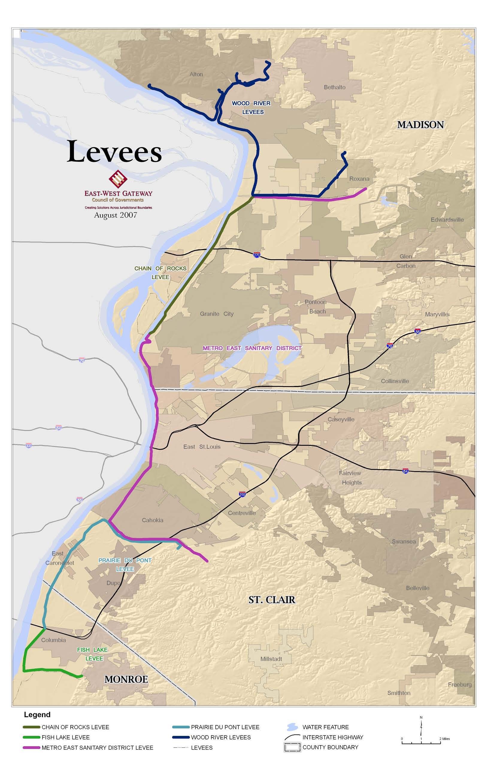
The American Bottoms in St. Clair, Madison and Monroe counties, Illinois is a broad floodplain
area situated along the easterly bank of the Mississippi River. The whole area which contains
approximately 150,000 people and numerous heavy industries and businesses, has a relatively
high groundwater level. It is protected from flooding by the Mississippi River by a system of
levees which is operated and maintained by four separate locally owned levee districts (Wood
River, Metro-East, Prairie Du Pont and Fish Lake) and the Army Corps of Engineers, which
maintains the federal levee along the Chain of Rocks Canal.
3
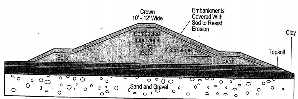
Man-made levee systems usually consist of earthen embankments and wall structures which are
designed and constructed to contain, control, or divert the rising flow of water so as to protect
low lying areas from periodic flooding. For stability, an earthen levee is constructed in pyramid
fashion so that its bottom width is several times its height. Therefore, constructed levees have a
large footprint requiring considerable land area. In urban areas where land is limited, concrete
and masonry floodwalls are often used. A long levee system, such as those of Southwestern
Illinois, may include a combination of earthen levees and floodwalls. Also, earthen levees are
generally constructed with compacted clay materials and an impervious clay base to prevent
water infiltration (see Figure 4).
Source: GAO 1993 Flood Study
Figure 4: Cross-Sectional View of an Earthen Levee
Generally, levees are specifically designed and constructed to withstand a certain flood
frequency. A ten to a fifty-year levee is usually considered to be an
agricultural
levee designed
to protect floodplain in agricultural areas from floods that may occur once every ten or fifty
years. These areas will experience flooding during major flood events (e.g., 100-year flood
events).
Urban
levees protect floodplains from 100-year floods or higher. The levee system of
3
With the exception of structures on the Chain of Rocks levee, all of the flood control facilities, including levees,
flood walls, floodgates, pump stations, etc., are locally owned and maintained. The Corps has assisted the districts in
the overall design, construction and routine inspections.
Electronic Filing - Received, Clerk's Office, January 18, 2008
9
Southwestern Illinois consists of main stem
urban
levees, which lay along a major river, in this
instance the Mississippi River and/or the Chain of Rocks Canal. Other levee structures in the
system include
tie back
or
lateral
levees, which extend from the main stem levee to bluff lines
(high ground) and are part of the line of protection against backflow during periods of high water
(Figure 5). Other key components of a levee system include pumping stations, gravity drains or
outlets, street closure gates and relief wells. Gravity drains or outlets are openings built through
the base of the levees and are designed to drain and convey floodwaters. These gravity
structures permit the outflow of stormwater that comes off the bluffs to the east when the river
stage is low. Gravity drains are equipped with closure gates to prevent the river flows from
entering the protected area during time of high river stages. Pump stations may be also operated
to drain the protected area from interior flooding (Figure 5).
Figure 5: Schematic of Standard Levee System
Source: FEMA
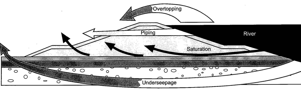
The four general ways a levee may fail include: overtopping; piping; saturation; and
underseepage (Figure 6). During an extreme flood situation, floodwaters may actually exceed
the designed water level of the levee and overtop it. For example, the Metro East levees have a
design water level of 52.0 feet. In 1993 floodwaters reached a level of 49.6 feet, which
approached but did not reach overtop conditions. Piping, or internal levee erosion, occurs when
Electronic Filing - Received, Clerk's Office, January 18, 2008
10
floodwaters enter the levee through animal burrows and/or plant and tree root channels.
Saturation failure is attributable to a levee that is saturated with floodwaters for an extended
period of time. Floodwater permeates and weakens the core of the levee, making it unstable.
Underseepage refers to floodwater that travels under the base of the levee via an unstable layer of
sand and gravel and weakens the base foundation of the levee from below (Figure 6).
To control for underseepage, relief wells are drilled on the interior side of the levee, and operated
during flood events to depress and eliminate seepage under the levee. Another method for
eliminating or controlling levee seepage is the construction of pressure berms. These berms are
designed as horizontal strips of materials built contiguous to the levee base on the interior sides
of the levee for the purpose of providing protection from seepage and resulting levee erosion.
Figure 6: Potential Levee Failure Scenarios
Source: FEMA
The size and height of the St. Louis urban levee system has grown over the years to its current
configuration to protect from the 500-year flood, a flood that has 0.2 percent chance of occurring
in any given year. Major levee improvements were completed with the passage of the Flood
Control Act of 1938. Today’s urban levee system consists of riverside levees and tie back or
wing-levees, canals, conduits, pumping stations, gravity drains and seepage relief wells. The
urban levee system has proven effective in protecting the American Bottoms from major
flooding events, including the flood of record in 1993 (a 300-year flood) and a 200-year flood in
1995 (Appendix A).
C. Levee and Drainage Districts
Below is a brief description of each the levee districts of concern in this report.
Wood River Drainage and Levee District
The Wood River Drainage and Levee District is chartered under the 1879 Illinois Levee Law,
and dates to 1910. A Board of Commissioners consists of three people appointed by the
Electronic Filing - Received, Clerk's Office, January 18, 2008
11
Madison County Board to three year staggered terms. The district employs a secretary-treasurer
and a superintendent, who hires full time and several part time maintenance workers.
The district, located in Madison County, is just upstream from the city of East St. Louis between
river miles 195 and 203 above the Ohio River (Figure 7). The communities of Alton, East Alton,
Hartford, Roxana, South Roxana, and Wood River are within the district. The levee district is
protected by an urban levee across the Mississippi River from St. Louis and St. Charles counties
in Missouri. This system includes approximately 21 miles of main line levee, 164 relief wells,
24 closure structures, 64 gravity drains and 7 pump stations. There are approximately 21 square
miles (13,700 acres) of bottomland and 7 square miles (4,700 acres) of hill land within the
district. The overtopping level is 52 feet.
The Wood River Drainage and Levee District protects significant industrial development.
Work on rehabilitation and reconstruction of the levee, pump stations, and other structures has
already begun. The levee district has been working with the Corps in planning and
implementing repairs and upgrades, but the notice of potential decertification that came in
August 2007 was unexpected. Significant work has already been completed and remaining
planned repairs should be sufficient for the levees to be recertified within the next few years.
The Wood River District financial statement for the year ending September 30, 2007, reports
general revenue of $656,000 from an equalized assessed valuation of property in the district, and
expenses of $554,000 for 2006, with a balance on hand of $858,000.
Electronic Filing - Received, Clerk's Office, January 18, 2008
Electronic Filing - Received, Clerk's Office, January 18, 2008
13
Metro East Sanitary District
The Metro East Sanitary District enabling legislation passed in 1907. A Board of five
Commissioners governs the district. Three of the Commissioners are residents of that portion of
the district in the county having the greater equalized assessed valuation of the district (currently
Madison County), and two are residents of that portion of the district having the lesser valuation
(currently St. Clair County). The board hires an executive director and the district employs 57
staff members.
The largest of the four locally maintained districts, the Metro East Sanitary District protects
96.32 square miles (61,645 acres). The district owns 2,776 acres. (See Figures 8 and 9) The
district owns approximately 37.5 miles of mainline levee, including north and south flanks;
16,425 feet of floodwall; 52.5 miles of canals; and 14 miles of sanitary sewers in service at the
present time.
4
The levee district includes the cities of Collinsville, Edwardsville, Glen Carbon,
Granite City, Madison, Pontoon Beach and Venice in Madison County; and Alorton, Brooklyn,
Cahokia, Caseyville, Centreville, East St. Louis, Fairmont City, Sauget and Washington Park in
St. Clair County. The overtopping level is 54.0 feet at St. Louis.
The district boundaries are fixed by the county court for taxation purposes. General revenue of
the district is obtained primarily from two sources – a direct tax in proportion to the assessed
valuation of all property within the district, and a replacement tax allocation (for the elimination
of personal property tax) from the State of Illinois sales tax revenue. The 2006 annual financial
report lists property taxes at $2,033,483; the replacement tax at $1,312,505; and numerous
miscellaneous revenue items for total general revenue of $3,678,258.
Administration expenses in 2006 were $2,171,799; general maintenance was $1,554, 935. The
2006 year end fund balance for general revenue was $4,949,854. In addition, the district has a
property tax for a Tort Liability Fund that generated $501,000 in 2006. The tort fund had a fund
balance of $6,698,104 on December 31, 2006.
4
Also included are six stormwater pump stations – Cahokia, Venice, Madison, South, North and East St. Louis
pump stations. Pumps remove water from behind the levees during interior flooding events, when stormwater water
comes into the flood plain from the bluffs to the east.
Electronic Filing - Received, Clerk's Office, January 18, 2008
Electronic Filing - Received, Clerk's Office, January 18, 2008
Electronic Filing - Received, Clerk's Office, January 18, 2008
16
Prairie Du Pont Levee and Sanitary District
Prairie Du Pont Levee District is chartered under the Illinois Sanitary District Act of 1907. It has
five-member board, elected in a general election and serving four-year terms, with two currently
from East Carondelet and one each from Dupo and Columbia. Members are elected from the
territory of the district in the two counties. The district has two full time and six part time staff.
The district protects 15 square miles (9,560 acres) and its mainline levees are 10.3 miles in
length (Figure 10). Structures include 5 steel gates and 9 gravity drains. Prairie Du Pont Levee
protects portions of the communities of Dupo, East Carondelet and Columbia in St. Clair County
and a portion of Monroe County. The district can levy property taxes and can issue general
obligation bonds. District revenue is approximately $140,000 per year from property taxes. The
district has a $60,000 annual bond issue payment and a $2 million bond capacity based on their
assessed valuation of which $750,000 is currently being used. The tax rate limit is 0.20 percent
of equalized assessed valuation and may be increased by referendum. They also levy a
stormwater tax of 0.03 percent. The district may issue general obligation drainage bonds and
interest tax, which can be authorized by referendum with no rate limit.
Fish Lake Levee District
The Fish Lake Levee District was established under the 1879 Illinois Levee Law, which was
recodified in 1955. The district has three board members elected from the district and from
Monroe County and city of Columbia, and two part time staff. Fish Lake District protects 4
square miles (2,440 acres) and has 4.9 miles of mainline levee (Figure 9). It has no gates and
currently has 9 gravity drains.
The district can levy three assessments: for annual maintenance; for original construction; and
for performance of additional repair work and construction of pumping plants. The Fish Lake
District 2007 financial report indicates revenue of $26,000 from assessments.
Electronic Filing - Received, Clerk's Office, January 18, 2008
Electronic Filing - Received, Clerk's Office, January 18, 2008
18
III. Flood Maps and Flood Insurance
Flood maps, known as Flood Insurance Rate Maps (FIRM), show high-risk areas where there is
at least a 1% annual chance of flooding (commonly called the 100-year flood). These areas are
designated as Special Flood Hazard Areas (SFHA) and flood insurance is required for those
property owners that have current mortgages from a federally regulated lender. While there are
several different kinds of SFHA designations, all such areas include the letter A in their
designation. The maps also show low or moderate risk areas where flood insurance is optional
and recommended. Currently much of the American Bottoms is considered to be protected from
Mississippi River flooding and not a SFHA. The revised maps will show nearly all of the
American Bottoms as an SFHA. When the risk designation officially changes (currently
predicted to occur in May 2009), the flood insurance rates will increase.
Under the National Flood Insurance Program (NFIP) property owners may take advantage of
lower rates by purchasing insurance before risk designations change. Currently anyone in the
area behind the levees who is in a protected zone can receive a lower cost insurance policy.
Residents who currently purchase flood insurance, or who purchase flood insurance before the
new maps become final will be able to receive lower rates, and the lower rates are transferable to
new owners as long as the insurance policy remains continuously in effect.
A. FEMA Mapping Process
FEMA expects to have preliminary flood insurance rate maps for the three counties completed
by March or April 2008. A public comment and appeal process will follow and FEMA officials
anticipate it will be about one year before the maps become final and all flood insurance and
other requirements take effect. Current FEMA operating procedures require maps to become
official as they are completed, and although congressional action could change FEMA
procedures, there is no guarantee that Congress will change the law or if there is a change, it is
unlikely to occur before the preliminary maps are released in early 2008.
FEMA contractors are assembling maps from best available, reliable topographic data. The
Illinois Water Survey is contracting with FEMA to do the mapping in Monroe County. PBS&J
Corporation is mapping St. Clair County. FMSM Engineers is mapping Madison County.
5
There are dual flood zones in the American Bottoms because the area is subject to flooding from
tributary streams as well as the Mississippi River. Areas subject to interior flooding will remain
as currently designated and subject to flood insurance restrictions regardless of what happens
with the Mississippi River Levees. The separate Interior Flood Control project may have an
impact on some of these areas if and when it is completed.
6
5
Contact information for mapping consultants: Illinois Water Survey -Sally McConkey 217-333-5482; PBSJ –
Mike DePue, MdePue@pbsj.com; FMSM – Don Armour, darmour@fmsm.com
6
The levees under consideration in the report address Mississippi River floodwaters only. Drainage from the bluffs
on the east side of the American Bottoms causes flooding on some of the tributaries, and that flooding is addressed
in a plan for interior flood control and habitat restoration that was completed by the St. Louis District of the Corps in
2003 and is authorized in the 2008 Water Resources Development Act.
Electronic Filing - Received, Clerk's Office, January 18, 2008
19
Although the remapping process is occurring nationwide, the Missouri and Illinois portions of
the region are on different timetables because they are in different FEMA regions.
7
The
proposed changes to flood maps in Illinois may take effect two to three years before new maps
will be published in Missouri. To facilitate a more equitable process, on September 25, 2007,
Congressman Jerry Costello filed the following proposed amendment to H.R. 3121 relating to
the National Flood Insurance Act of 1968:
“USE OF MAPS FOR RATES The Director (of FEMA) shall not
adjust the chargeable premium rate for flood insurance under this
title based on an updated national flood insurance program rate
map or require the purchase of flood insurance for a property not
subject to such a requirement of purchase prior to the updating of
such national flood insurance program rate map until an updated
national flood insurance rate map is completed for the entire
district of the Corps of Engineers affected by the map, as
determined by the district engineer for such district.”
If enacted, the Costello amendment could potentially give the four Illinois levee districts two or
three years to raise funds and make necessary repairs of the design deficiencies, but such an
extension will still require an extraordinary effort in order to complete design and engineering
studies and build the necessary relief wells before the NFIP flood insurance rate maps are
finalized.
8
B. Restoration Zone (AR Zone) Designation
The National Flood Insurance Program requires FEMA to map areas that are not certified to
protect against a 100-year flood as Special Flood Hazard Areas, but it also allows FEMA to map
areas previously shown as protected by a levee as a “Restoration Zone” (AR Zone). Because the
American Bottoms has historically been protected by levees and work has begun to continue to
provide that protection, FEMA suggests that an AR designation would provide many short-term
benefits. In a letter sent to all affected communities, dated October 5, 2007, FEMA suggested
that the levees might meet requirements for AR Zone designation (Appendix B
).
AR Zone
indicates that the increased flood hazard is considered temporary and that restoration of
protection is underway. An application to FEMA that is submitted before January 30, 2008
would allow sufficient time for FEMA to make a determination and incorporate the designation
in FEMA’s preliminary maps.
The application process requires that communities currently designated as protected make a
written request to be considered for AR Zone. According to FEMA, “communities” means all of
the communities participating in the National Flood Insurance Program. The communities
include cities, villages and counties representing the unincorporated areas. In an area such as the
American Bottoms where there are many communities, FEMA will accept a joint application as
long as it includes a request letter signed by the chief elected official from each of the cities,
7
Illinois is in Region V, headquartered in Chicago and Missouri is in Region VII, headquartered in Kansas City.
8
How the mapping schedule in Illinois might be affected by the amendment is difficult to predict with certainty
because it depends on progress in other areas.
Electronic Filing - Received, Clerk's Office, January 18, 2008
20
villages and counties.
9
The request will need to include technical information about how the
plan to correct design deficiencies will be implemented over a period not to exceed ten years, if
being done in cooperation with a federal agency (or five years if a non-federal project). Each
community will also be responsible for adopting a resolution passed by the city or county
legislative body – saying they want to apply for the AR Zone designation, that they have not
applied before, that they are not in litigation over levees, and that they have a plan to meet
requirements for federally supported restoration. The communities must also be certified by the
Corps that they are protected against a 33- year flood, a requirement that the Corps has indicated
will likely be met, based on a survey currently underway.
For the purpose of determining future development restrictions, the law makes a distinction
between “developed” and “undeveloped” areas. A community must adopt a map or legal
description designating the developed area, to be submitted with the AR Zone request. As
defined in the rule at 44 CFR 59.1(a)-(c) the developed area encompasses the larger urbanized
area as well as isolated developed subdivisions beyond the urbanized area. Developed area also
recognizes vested land development interests by identifying land that is planned and permitted
and where construction is underway. FEMA indicates that while the communities will need to
include a map of developed areas in the initial application, the map may be later amended to
include any additional areas that are developed (or where construction has begun) during the
time before the map becomes official. After FEMA sends the letter of final determination on the
AR Zone, the communities will then have time to legally adopt their official map.
C. Benefits of AR Zone
The AR Zone designation helps eligible communities establish levee restoration plans that, when
implemented properly, will allow the communities to remove the SFHA designation from the
previously protected areas as soon as the levee system is restored. With this AR Zone
designation indicating that a restoration plan is in place, developers will be more confident in the
long-term success of their investments.
There are other significant benefits. The flood insurance premium rates are lower in SFHAs
designated AR Zone than the rates in SFHAs with other flood insurance risk zone designations.
Rates in the AR Zone are similar to the rates available to people who have purchased insurance
while the area is recognized as protected and grandfathered into the required program. The
structure elevation requirements in AR Zone areas are more relaxed than the elevation
requirements in other SFHAs
10
. The designation of AR Zone areas also provides a strong
incentive for communities to expeditiously restore base flood protection in at-risk areas.
9
There are currently three communities in the Metro East that are not part of the NFIP that can be included in the
requested application. If they applied on their own, they would not be eligible. However, the remapping process can
include these communities in a joint application. Therefore it is considered preferable to consolidate the process,
with each of the counties to apply for the AR Zone designation on behalf of all communities. See Appendix B for a
list of all elements needed for a request.
10
In areas designated as AR Zone, the minimum elevation required for all new construction in areas identified as
developed is 3 feet above the highest adjacent grade or the AR Zone Base Flood Elevation, whichever is lower. For
new construction in AR Zone that is outside areas already designated as developed, the requirement is 3 feet in areas
where base flood depth are projected to be less than five feet or the AR Zone Base Flood Elevation for any areas
where the projected flood depths exceed 5 feet.
Electronic Filing - Received, Clerk's Office, January 18, 2008
21
D. Zone A99
As adequate progress is made on any levee reconstruction project, a community may request
FEMA to revise the AR Zone designation to A99. Zone A99 designation indicates that for
insurance rating purposes, the levee is considered complete. However, NFIP insurance
requirements still apply.
11
Adequate progress includes: 100% project funding authorized; 60%
appropriated; 50% project cost expended and all critical features as determined by FEMA are
under construction and at least 50% completed. The Zone A99 designation is based on the
protection from base flood (100-year flood). As soon as FEMA is notified that the project is
complete, FEMA can remap the area to delineate a flood-protected zone.
11
While insurance is still required, it will be offered at the lower rates available in protected zones.
Electronic Filing - Received, Clerk's Office, January 18, 2008
22
IV. Current Status of Deficient Illinois Levees
Although all of the levees in the American Bottoms held during the 1993 flood, all of them
required flood fighting – use of sand bagging around sand boils that occur from underseepage,
additional rock brought in to shore up certain areas, etc. According to FEMA rules, the Corps of
Engineers was asked to certify that the levees would hold without support of flood fighting. At
that juncture, the Corps determined that by its own rules governing levels of safety they could
not certify that the levees are capable of providing base flood protection.
The Corps requires that levees exceed minimum design requirements and they measure it by
something called a Factor of Safety (FS). Factor of Safety is a calculation of the risk that a
failure will occur. Therefore, although an FS of 1.0 means that a structure meets minimum
theoretical design requirements the Corps requires a minimum FS of 1.6 to provide a margin of
safety, thereby reducing the risk that a structural failure will occur. Tables 2 through 5 on the
next few pages specifically show in the far right hand column how seepage deficiencies are rated
with the Factor of Safety.
The Corps of Engineers studies to date have all focused on maintaining a 500-year flood
protection. However, FEMA requirements for the remapping process require that the levees only
need to protect for a base flood, a less stringent requirement. Therefore, the Corps cost estimates
and much of the projected work reported here exceed the minimum necessary to meet base flood
protection. It is difficult to separate out costs, since much of the project work addresses
structural aspects of the levees. Data available at the beginning of this process in September
2007 was therefore based on estimated costs for 500-year protection. The Corps has been
providing updated analyses as they develop estimates for protection for base flood levels. Table
6 in Section V provides the most up to date information available.
The federal government requires that all Corps projects have a 35% local match contribution,
except for federally owned projects. The Chain of Rocks levee borders the barge canal that is a
federal project, so it does not require a local match.
Wood River Drainage and Levee District
The Corps of Engineers divides the Wood River District into three parts, because there are three
independent levee systems in the district. Table 2 (on pages 23 and 24) provides a summary of
the deficiencies for each of the three sections.
Over the last several months the Corps has worked to define actual costs to improve the levee to
base flood protection. The Corps has now determined that to meet the base flood protection,
they must build 60 relief wells for underseepage control at a cost of approximately $4 million.
Moreover, in order to complete the certification of the levee at the 33-year flood as required for
the AR Zone designation, the Corps is looking for other funds internally to complete an
assessment of the condition of gravity drains. In the short term, to meet the base flood protection
the Corps will work with the levee district to create an operational protocol for use in case of
Electronic Filing - Received, Clerk's Office, January 18, 2008
23
rising waters. They expect to have the evaluation of the drains and the protocol in place in time
to meet the January 30 date for submitting the AR Zone application.
Table 2a
Deficiencies in the Wood River Drainage and Levee District – Upper Levee System
Levee Feature
Type
Cause of
Potential
Problems
Total Number of
Features
Number of
Features
Affected by 100-
Yr Flood
Predicted Performance During
a 100-Yr Flood
Gates
Corrosion of
Steel Gates
6
4
No Anticipated Problems
Except For Gate Leakage
Seepage
Design
Levee Length
27,430 LF
Levee Length
27,430 LF
Anticipate Seepage Problems
23,270 LF FS*
≥
1.6
2,880 LF 1.3
≤
FS < 1.6
1,280 LF FS < 1.3
Drains
Exceeded
Design Life
6
3 - 18” CMP
2 - 60” CMP*
1 - 72” CMP
6
3 - 18” CMP
2 - 60” CMP*
1 - 72” CMP
Anticipate Problems w/ CMPs
Past Poor Performance
1973 2 – 60” CMPs Failed
CMP= Corrugated Metal Pipe
* Lined With 54” HDPE Pipe
Source: USACE, St. Louis District
Electronic Filing - Received, Clerk's Office, January 18, 2008
24
Table 2b
Deficiencies in Wood River Drainage and Levee District – Lower Levee System
Levee Feature
Type
Cause of
Potential
Problems
Total Number of
Features
Number of
Features Affected
by 100-Yr Flood
Predicted Performance During
a 100-Yr Flood
Gates
Corrosion of
Steel Gates
17
9
No Anticipated Problems
Except For Gate Leakage
Seepage
Design
Deficiency
Levee Length
72,020 LF
Levee Length
54,900 LF
Anticipate Seepage Problems
47,970 LF FS
≥
1.6
1,590 LF 1.3
≤
FS < 1.6
5,340 LF FS < 1.3
Drains
Exceeded
Design Life
27
1 - 18” CMP
6 - 24” CMP
5 - 30” CMP
2 - 36” CMP
4 - 42” CMP
5 - 48” CMP
1 - 60” CMP*
1 - 72” CMP**
2 - 72” CMP
27
1 - 18” CMP
6 - 24” CMP
5 - 30” CMP
2 - 36” CMP
4 - 42” CMP
5 - 48” CMP
1 - 60” CMP*
1 - 72” CMP**
2 - 72” CMP
Anticipate Problems w/ CMPs
Past Poor Performance
1993 1 – 60” CMP Failed
2005 1 – 72” CMP Failed
(Riverside of Gatewell)
* Lined With 54” HDPE Pipe
Table 2c
Deficiencies in Wood River Drainage and Levee District – East & West Forks
Levee Feature
Type
Cause of
Potential
Problems
Total Number of
Features
Number of
Features Affected
by 100-Yr Flood
Predicted Performance During
a 100-Yr Flood
Gates
Corrosion of
Steel Gates
3
0
No Anticipated Problems
Except For Gate Leakage
Seepage
Levee Length
14,570 LF
Levee Length
1,700 LF
No Anticipated Problems
14,570 LF FS
≥
1.6
0 LF 1.3
≤
FS < 1.6
0 LF FS < 1.3
Drains
Exceeded
Design Life
8
1 - 12” CMP
2 - 24” CMP
3 - 36” CMP
1 - 42” CMP
1 - 48” CMP
8
1 - 12” CMP
2 - 24” CMP
3 - 36” CMP
1 - 42” CMP
1 - 48” CMP
Anticipate Problems w/ CMPs
Source (2b and 2c): USACE, St. Louis District
Electronic Filing - Received, Clerk's Office, January 18, 2008
25
The Corps estimates a total cost of $33 million to re-establish 500-year protection along the
Wood River Levee. The Corps is developing plans for lining the larger pipes (36 inches and
larger) and replacing any smaller pipes that are showing signs of failure. Additional relief wells
are also needed. Local match required for all reconstruction work will be approximately $11.5
million.
Now that the Water Resources Development Act of 2008 (WRDA) has become law, the Wood
River Levee District 500-year levee protection project is authorized. If the 2008 federal budget
provides an appropriation for the project ($685,000 is in the House version of the bill), it will
enable work to start on the levee repair. The levee district will need $621,000 to meet it 35%
obligation and catch up on its share of match from earlier work. Madison County has committed
to making a loan to the levee district to cover any shortfall in levee district funds for that initial
match, and the county will make that funding available in early 2008. In addition, the levee
district is implementing a reassessment in this fiscal year that will take effect by the end of 2008.
This reassessment will enable the district to raise close to $1 million per year, and to offer bonds
to pay, in advance of federal funding, for reconstruction to protect at the base flood elevation
requirements.
In order to begin work under the federal cost share program once federal funds are appropriated,
Madison County and the Corps will need to sign a Project Cooperation Agreement (PCA) that
details cost sharing arrangements. It is possible to write that agreement so that the county can
front load its share of the costs, and receive credit for its local match to federal dollars.
However, this may be risky since payback would be contingent on congressional approval of
future appropriations. Therefore, the Corps Headquarters and the Assistant Secretary of the
Army are reluctant to approve such agreements.
12
With all money in hand, the Corps estimates a minimum of 18 months to two years to complete
the 60 relief wells that should bring certification for base flood protection. (The process requires
design of the relief wells, contracting for the work, permits, and then construction.)
Chain of Rocks
The Chain of Rocks levee is a 100% federally funded project that is fully authorized and will be
completed in approximately five to seven years at current rates of federal appropriations.
Authorized at $46,400,000, the project is nearly half complete. There is $4.5 million in the FY
08 Budget, and $22.4 million that remains to be appropriated. This levee provides critical
protection to the central region of the Metro East Sanitary District; therefore the certification of
12
Local Corps officials said that it is theoretically possible to obtain a PCA that commits the Corps to credit local
funds expended in advance, if and when appropriations are ever made, without guaranteeing that the appropriation
will be made. A commitment can also offer potential for reimbursement of local funds, if the amount spent locally
exceeds that total amount necessary for local match, but it likewise does not provide a guarantee. In the case of St.
Louis City, an effort to obtain special legislation that would commit the Corps to provide reimbursement of local
funds spent before there was a congressional appropriation was unsuccessful in 2007. The Corps and the City are
now waiting to see if there is an appropriation, which will enable the city to expend money with confidence that it
will be reimbursed. If there is no appropriation (due to continuing resolutions on the federal budget), representatives
from the Corps suggest that the City may seek to act on a PCA that does not guarantee credit or reimbursement of
expenditures.
Electronic Filing - Received, Clerk's Office, January 18, 2008
26
the entire district will be contingent on completion of repairs to Chain of Rocks and the Metro
East Levee.
Table 3
Deficiencies in Chain of Rocks Canal East Levee
Levee Feature
Type
Cause of
Potential
Problems
Total Number
of Features
Number of
Features Affected
by 100-Yr Flood
Predicted Performance During
a 100-Yr Flood
Seepage
Design
Deficiency
Levee Length
46,500 LF
Levee Length
46,500 LF
No Anticipated Problems when
implementing USACE Flood
Operating Plan
Drains
1
1
No Anticipated Problems
Source: USACE, St. Louis District
Metro East Sanitary District
The East St. Louis Levee will require an estimated $40 million to restore. The Engineering
Design Report, which is 40% complete, will be finished in September 2008, at which time more
accurate figures will be available. The initial rehabilitation project for this levee was authorized
and has a $2.5 million appropriation. Table 4 below shows the identified deficiencies.
Table 4
Deficiencies in Metro East Sanitary District
Levee Feature
Type
Cause of
Potential
Problems
Total Number
of Features
Number of
Features Affected
by 100-Yr Flood
Predicted Performance During
a 100-Yr Flood
Gates
Corrosion of
Steel Gates
20
015
No Anticipated Problems 2
Closures Closed With
Crushed Stone Fill
Seepage
Design
Deficiency
Levee Length
105,987 LF
Levee Length
105,987 LF
Anticipate Seepage Problems
69,112 LF FS
≥
1.6
2,400 LF 1.3
≤
FS < 1.6
34,475 LF FS < 1.3
Drains
Exceeded
Design Life
5
1 - 12” CMP
1 - 18” CMP
1 - 24” CMP
2 - 84” CMP
8
1 - 12” CMP
1 - 18” CMP
1 - 24” CMP
2 - 84” CMP
Anticipate Problems w/unlined
CMPs
Source: USACE, St. Louis District
Electronic Filing - Received, Clerk's Office, January 18, 2008
27
At current rates of appropriation, which the Corps estimates at $4 million per year, this project
will take seven years (beginning in 2009) to complete, and require a total of $14 million in local
match or $2 million per year over the seven years. Legal authority may determine that the
district can use its Liability and Tort Fund revenues to advance its share of the project cost, and
thus complete reconstruction to base flood protection. However, since Chain of Rocks and
Metro East are a combined levee system, the protection will only be available when both are
certified.
Prairie Du Pont and Fish Lake Districts
Although the problems are identified by each district these two levees are treated as one project
by the Corps of Engineers as they plan the Design Deficiency Study. The Corps has identified
potential problems with the levees as shown in Tables 5a and 5b.
Table 5a
Deficiencies in Prairie Du Pont Levee and Sanitary District
Levee Feature
Type
Cause of
Potential
Problems
Total Number of
Features
Number of
Features
Affected by 100-
Yr Flood
Predicted Performance During
a 100-Yr Flood
Gates
Corrosion of
Steel Gates
5
4
No Anticipated Problems - 2
Closures Closed With
Crushed Stone Fill
Seepage
Design
Deficiency
Levee Length
54,575 LF
Levee Length
54,575 LF
Anticipate Seepage Problems
40,100 LF FS
≥
1.6
11,475 LF 1.3
≤
FS < 1.6
3,000 LF FS < 1.3
Drains
Exceeded
Design Life
9
1 - 12” CMP
1 - 14” CIP*
1 - 24” CMP
1 - 24” CMP*
1 - 36” CMP
1 - 36” CMP*
1 - 48” CMP*
2 - 60” CMP*
9
1 - 12” CMP
1 - 14” CIP*
1 - 24” CMP
1 - 24” CMP*
1 - 36” CMP
1 - 36” CMP*
1 - 48” CMP*
2 - 60” CMP*
Anticipate Problems w/ unlined
CMPs
* Lined With HDPE Pipe
Source: USACE, St. Louis District
Electronic Filing - Received, Clerk's Office, January 18, 2008
28
Table 5b
Deficiencies in Fish Lake Drainage and Levee District
Levee Feature
Type
Cause of
Potential
Problems
Total Number
of Features
Number of
Features Affected
by 100-Yr Flood
Predicted Performance During
a 100-Yr Flood
Gates
0
0
No Gates Exist
Seepage
Design
Deficiency
Levee Length
25,613 LF
Levee Length
25,613 LF
Anticipate Seepage Problems
5,384 LF FS
≥
1.6
6,029 LF 1.3
≤
FS < 1.6
14,200 LF FS < 1.3
Drains
Exceeded
Design Life
9
1 - 18” CMP
1 - 30” CMP
3 - 84” CMP
9
1 - 18” CMP
1 - 30” CMP
3 - 84” CMP
Anticipate Problems w/unlined
CMPs
Source: USACE, St. Louis District
The Corps estimates $2 million is needed for the Design Deficiency Study, of which $700,000
will be required as local match. Since the two districts combined bring in only $165,000
annually, there is concern about meeting the local match even for this initial reconnaissance.
The Prairie Du Pont District reports that it has already committed to put up $250,000 of
necessary match toward the proposed Corps study and has an agreement from St. Clair County to
cover the rest. They are hoping to secure a portion from Monroe County and the Fish Lake
District.
Reconstruction costs are not known at this time, but the Corps has given an unofficial estimate of
$20-25 million. The length of levee that has been identified as potentially deficient is
approximately the same as the Chain of Rocks levee, and that project cost is $46 million;
therefore, a worst case estimate could reach $52 million with inflation factored in over a ten year
period. Conservatively then, the local match required is in the range of $7 million to $18.2
million.
Levee district officials in Fish Lake and Prairie Du Pont have stated that they intend to ask the
Corps of Engineers to re-consider the decertification of the levees in that area. Citing the fact
that the levees effectively withstood the 1993 and 1995 floods and that since that time the levees
have had significant updates to pumps and gates, district officials do not believe that the levees
should be decertified without more research. Their recommendation is that the levees be
provisionally certified
13
pending the results of the Design Deficiency Study proposed by the
Corps of Engineers. The levee officials say they support the importance of the Design
Deficiency Study, but argue that without the study there is no sound basis for decertification
now.
13
The PAL – Provisionally Accredited Levee – procedure was established primarily to assist levee owners, the
community, or local project sponsors by providing additional time to gather full documentation on a levee that is
eventually expected to be accredited. Such provisional accreditation will rely on close cooperation with the Corps
of Engineers.
Electronic Filing - Received, Clerk's Office, January 18, 2008
29
V. Project Costs and Schedule
The total cost to address all design deficiencies and reconstruction in the five levees that
comprise the Southwestern Illinois levee system presented in this report will be somewhere
between $136 and $180 million in year of expenditure dollars.
14
Since the Corps has not
completed necessary studies, particularly in the Prairie Du Pont and Fish Lake Districts, this is a
very preliminary estimate, but it is a good indication of the scale of funding required to restore
the flood protection system in the region.
Ultimately these expenditures will bring the levees up to the 500-year base level of protection.
To date, federal project authorizations total $78.5 million and $28.1 million has been
appropriated. It is important to realize at this stage that not all levees will be eligible for
certification at the same time. However, given a proactive strategy and disciplined schedule to
correct the deficiencies it is reasonable that each levee in the system can be certified within the
10 year time period allowed by the AR Zone classification.
As noted above, progress in necessary studies and repair activities for each district varies widely
in terms of congressional authorization, rates of federal appropriation and capacity for local
sponsorship.
Below in Table 6 is a summary of the current status of each of the five levees, and a visual image
of the levees and financial requirements is shown in Figure 11.
In order to pay for construction work, the Corps depends on authorizing legislation for each
individual project, and a subsequent series of annual budget appropriations leading to completion
of the project. The slow pace of appropriations could significantly delay project completion.
The Corps adheres to a specific protocol and sequence of project phases to ensure orderly
progress of engineering design and construction leading to completion of the project as shown in
Table 7.
14
The term “year of expenditure” means that the projected costs have been adjusted upward to include annual
inflation in construction costs.
Electronic Filing - Received, Clerk's Office, January 18, 2008
30
Table 6
Summary of Estimated Project Costs and Status of Funding
Levee District
Wood River
Metro East
Chain of Rocks
Fish Lake
Prairie Du Pont
Total
Repair and Reconstruction
Cost
$29.6
Est. $40-$52
$46.6
Unknown, see PDP
Unknown; estimate
$20 to $52
$136 to $180
1
Federal Funds
Authorized/Appropriated
$29.6/ $1.6
$2.5 / $2.5
$46.4 / $24
0
0
$78.5 / $28.1
Remaining Federal
Funds to be
Authorized/Appropriated
0/ $28
Est. $26 / $26
0 / $22.4
See PDP
$20 to 52/ TBD
$46 -78 / $96 - 128
Local Matching Funds
Required / Spent
$9.9 / $0.4
$14 / 0
0
See PDP
$7 to $17.5 / 0
$31 to $47
Estimated Time to
Complete
3 to 7 years
10 years
5 to 7 years
10 years
10 years
10 years
Note: All dollar amounts in $ millions. When different time or cost estimates have been provided by sources for this report, the longer time
period and higher cost estimate is shown.
1
Costs shown are in year of expenditure dollars, adjusted for inflation.
Electronic Filing - Received, Clerk's Office, January 18, 2008
31
Table 7
Fiscal Capacity of Levee Districts
Levee District
Wood River
Metro East
Chain of Rocks
Fish Lake
Prairie Du Pont
Total
Annual Revenue
$656,584
$3,678,258
2
NA
$26,000
$426,291
$4,787,133
Annual Operating
Expenses
$554,378
$3,261,626
NA
$5,000
$394,827
$4,215,831
Funds Potentially
Available for
Capital
Expenditures
$1,279,750
$4,262,360
NA
$659,349
cash & equivalent
$6,201,459
Local Matching
Funds Needed
$4,101,200
$14,000,000
none
- - - $750,000 - - -
$18,851,200
Revenue Source(s)
Property tax
EAV
1
Assessed
valuation direct
tax/Illinois sales
tax
Federal
Appropriations
Maintenance
assessment /
Construction
assessment &
additional repair
EAV property
tax /stormwater
tax
1
Equalized Assessed Valuation
2
Tort liability fund potential: add $6,698,104
Electronic Filing - Received, Clerk's Office, January 18, 2008
32
Table 8
Corps of Engineers Levee Project Phases
Electronic Filing - Received, Clerk's Office, January 18, 2008
Electronic Filing - Received, Clerk's Office, January 18, 2008
34
A normal Reconnaissance Report, the first order of business for the Corps, leading to a
Feasibility Report, takes about twelve months to complete. A Feasibility Report can take three
to four years. The next project phase is Preconstruction Engineering & Design, which can take
two years or more to complete and includes the Engineering and Design Study. Typically each
of these processes is funded separately and requires a separate Project Cooperation Agreement
(PCA) signed between the Corps and the levee district(s). Before a PCA can be signed,
Congress must authorize the project and at least some funds must be appropriated. The
Construction Phase, which includes any real estate acquisition and plans and specifications for
construction can also take two years or more.
The Corps has indicated they have a well-defined administrative system to assure expeditious
letting of contracts for construction and re-construction work. The final project phase is the
Certification Study conducted by the Corps and funded by Inspection of Completed Works
(ICW) federal funds. Operations and Maintenance falls on the shoulders of the local sponsors
and levee districts, with periodic inspections done by the Corps. As Table 7 indicates, following
this typical process can easily require twenty years, and ten years for a project from start to finish
is exceptional.
There have been circumstances where local sponsors have exceeded the local cost share in order
to expedite a certified levee project. Congress cannot, however, guarantee that the local sponsor
will be reimbursed or credited in such a case. As part of a PCA, credits can be granted and the
non-federal sponsor can accelerate a project. However, special care must be taken to draft
appropriate language in the PCA to facilitate the potential for subsequent credit or
reimbursement from the federal government.
Electronic Filing - Received, Clerk's Office, January 18, 2008
35
VI. Next Steps – A Path to Rebuilding
A coordinated regional strategy will be the most effective way to address the repair and
restoration of the flood control system in Southwestern Illinois. There are four levee districts
that are individually responsible for maintaining flood control facilities, along with the Chain of
Rocks Canal levee maintained by the Corps. The future of the five facilities are inextricably
linked. Failure of any one will have regional consequences. We are therefore recommending
that the leadership of the counties and levee districts adopt an overall regional strategy. That
strategy might include the following next steps, all of which should be substantially
accomplished by the end of January 2008:
A. Creation of a Leadership Task Force
The three affected counties should consider establishing a task force that can provide
leadership in devising a strategy for action that includes development of a plan for repair
and restoration of the levees that will most quickly secure FEMA protected zone status.
The task force should have members from the public and private sectors and include
representation by the affected levee districts.
The task force can be staffed by a public agency such as East-West Gateway Council of
Governments or by private consultants. The group can provide a regular source of advice
and feedback in the development and implementation of a plan and provide a source of
local influence in obtaining support from other political entities.
B. Immediate Application for “AR Zone” Protected Status
In the absence of an immediate response, the decertification of levees will result in large
areas being designated as special flood hazard areas when preliminary flood insurance
rate maps are released in early 2008. This is the same designation that would be used if
there were no levees at all in place and the area was completely unprotected from
flooding. While those maps will not become final until approximately May 2009, the
uncertainty and doubt created by the unprotected designation will have a chilling effect
on plans and prospects for economic growth. The AR Zone is a transitional designation
that recognizes that the area has been adequately protected from flooding in the past and
is now in a transitional process to restore that protection. The AR Zone designation
confirms there is a plan to restore the levees and also provides significant relief in the
insurance rates and requirements for new development. Further, it will signal that there is
a plan in place that will fully restore adequate flood protection within ten years.
FEMA has indicated that a joint application representing all communities involved in the
National Flood Insurance Program will be an effective means of applying for the AR
Zone. There are a number of specific steps required to qualify for AR Zone status.
Those steps must be completed by the end of January 2008 to be assured that the
preliminary maps will reflect the transitional status of the area. Completing the
requirements will require an immediate mobilization of efforts to develop a financing
plan and implementation plan. It will also require the agreement of every incorporated
Electronic Filing - Received, Clerk's Office, January 18, 2008
36
area to comply with the terms of AR status. For a complete list of all of the steps to
qualify for AR designation
,
see Appendix B.
C. Development of a Ten-Year Plan to Restore the Flood Protection System
The progress of each of the levee districts and the Corps in determining and repairing
flood control facilities is uneven. The most advanced in the process is the Wood River
Levee District, which has most or all of the needed federal funding now authorized
although only partially appropriated. By contrast, the Fish Lake and Prairie Du Pont
districts have very little funding in place and no planning and design work has been done.
None of the districts, however, has made sufficient progress to avoid decertification and
flood zone designation in the final flood insurance maps to be issued in May 2009. It
appears that all are considering a plan to secure necessary funds to meet the local
required match on the federal projects. Identifying the source of matching funds is
needed to meet federal certification requirements. What is not so clear is whether the
counties might have funds to move forward with the work without waiting for the slow
process of the federal government funding.
To qualify for the beneficial AR Zone status, the community will have ten years to
restore the flood control system. A ten-year plan would include financial, design and
construction elements. While a ten-year plan can include use of federal funding to pay
for 65% of the costs, at the current pace of appropriations (especially considering that
much of the needed work is not yet authorized by Congress) ten years is an optimistic
scenario for completion of all the work necessary to restore the levees. Any plan must
therefore consider options for state and local funding that can speed the process of
reconstruction, as well as options for speeding the planning, design and construction
work should the Corps not be able to meet the ambitious schedule. FEMA has already
indicated that an AR Zone application should use the full ten years allotted in describing
the plan for completing the reconstruction, and notes that a more rapid completion will
enable an earlier re-certification of the levees.
D. Secure Expert Assistance in Financing and Engineering
Given the substantial legal, financial, design and construction issues that will need to be
addressed by local leadership, it will be useful to retain independent experts to advise on
these subjects. While federal officials will continue to support local efforts at levee
repair, the local leadership should have the benefit of independent advice on complex
financial and engineering questions to be able, for example, to challenge the flood
insurance maps or to work with the Corps to reduce the costs of needed repairs.
E. Community Engagement
Citizens and businesses will need to be fully aware of the risks of living in the flood
plain, even when it is protected by levees. Further, the public and the business
community will need to be partners in the adopted strategy of levee restoration.
Electronic Filing - Received, Clerk's Office, January 18, 2008
37
If the counties agree to pursue a designation of AR Zone for the short term, then the
community engagement process will also be important in obtaining the necessary
resolutions in all of the affected cities and in building support for any necessary local
funding to pay for the work that needs to be done to restore the levees as quickly as
possible.
The community engagement effort should strongly emphasize the need for property
owners to purchase flood insurance at favorable rates prior to the final maps being
published in 2009. If this opportunity is lost, financial consequences on those property
owners will be magnified considerably.
F. Secure Funding for Immediate Activities
Funding will be immediately required to maintain the current pace of local planning
efforts to secure the AR Zone status, develop the ten-year strategy and plan for levee
restoration, to form and staff the task force, and to retain appropriate expert assistance to
support good decision-making by area leadership.
East-West Gateway may have approximately $200,000 available from the new
comprehensive planning program for regional planning commissions that was recently
authorized by the Illinois legislature to support staff efforts. Additional funds may be
necessary to retain outside experts when needed.
It is critically important, given the substantial public safety and economic consequences
involved, that the efforts to restore the flood control system in Southwestern Illinois move
forward with energy and urgency. This will require a high degree of cooperation between local,
state and federal authorities, and the full participation of the private sector. If the above steps
can be substantially accomplished by the end of January 2008, that will send a signal to the
federal government, the public and area businesses, that the regional leadership is engaged and
focused on this important problem.
Electronic Filing - Received, Clerk's Office, January 18, 2008
38
Appendix A: River Stages
Mississippi River Flood Stage Impacts
River Gauge
Height
Impacts
54.0
The Metro East St. Louis and Fish Lake levees which protect 71,000 acres
are overtopped.
52.0
St. Louis floodwall is overtopped.
50.6
This the 500-year frequency level.
49.6
This is the RECORD FLOOD LEVEL that was reached on August 1,
1993.
49.0
Hartford IL Public Water supply is threatened.
48.0
The Harrisonville and Prairie Du Pont Levees protect 37,360 acres.
47.9
This level is expected to be met or exceeded on average once every 200
year.
47.7
The Columbia levee protects 14,000 acres.
46.1
This river level is expected to be exceeded once in every 100 years.
44.1
This river level is expected to be exceeded once in every 50 years.
44.1
Chouteau Island Pump Station begins to flood. Power to the Chouteau
Island Pump Station disconnected.
43.2
This flood level was reached on April 28, 1973.
42.0
Riverview Boulevard in City of St. Louis becomes flooded.
42.0
This level is expected to be met or exceeded on average once every 25
years.
41.1
This level is expected to be met or exceeded on average once every 20
years.
40.0
Major flooding begins. At this level the Chouteau Island levee, protecting
2,400 acres is overtopped.
38.5
This river level is expected to be exceeded once in every 10 years.
Electronic Filing - Received, Clerk's Office, January 18, 2008
39
River Gauge
Height
Impacts
36.0
Railroad tracks become flooded.
35.8
This level is expected to be met or exceeded on average once every five
years.
35.0
Moderate flooding begins.
33.0
Floodwall at Prairie Street in the City of St. Louis is closed.
31.0
Water begins entering the downtown parking garage.
30.0
Floodwall at Laclede’s Landing in City of St. Louis is closed. Also this
level is expected to be met or exceeded on average once every two years.
26.0
At 26 feet, several levees protect 2,000 acres.
18.5
Levee parking begins to be inundated.
Source: National Weather Service http://www.weather.gov/ahps/forecasts.php
Electronic Filing - Received, Clerk's Office, January 18, 2008
40
Appendix B: FEMA Notification Letter and AR Zone Submittal Requirements
DEACCREDITATION NOTIFICATION LETTER
[Mr./Ms.] (Full Name of Community official)
(Title of Community Official)
(Address)
(City, State Abbreviation, and Zip Code)
Dear
[Mr./Ms.] (Last Name of Community Official)
:
This letter is in regard to the levees shown on the effective Flood Insurance Rate Maps (FIRMs) and in
the effective Flood Insurance Study (FIS) reports for communities in Madison, St. Clair and Monroe
Counties in Illinois. As you may know, the Department of Homeland Security, Federal Emergency
Management Agency (FEMA), is in the process of producing new flood risk maps for the nation and, as
part of that effort, countywide FIS reports and Digital Flood Insurance Rate Maps (DFIRM) will be
issued for Madison, St. Clair, and Monroe Counties.
As part of FEMA’s effort to produce the DFIRM, it was determined that the flood hazard information
presented on the effective FIRM and in the effective FIS report is based, in some areas, on flood
protection provided by at least one of five levee systems in the Metro East area that include the following:
Wood River Drainage & Levee District
Chain of Rocks Levee
Metro East Sanitary District
Prairie Du Pont Levee & Sanitary District
Fish Lake Drainage & Levee District
Based on the information available and on the mapping standards of the National Flood Insurance
Program (NFIP) at the time the FIS was performed, FEMA accredited these levee with providing
protection from the flood that has a 1-percent-chance of being equaled or exceeded in any given year.
The 1-percent-annual-chance flood also is referred to as the base flood.
Recently, FEMA was informed by the U.S. Army Corps of Engineers (USACE) that they have
determined the levees identified above do not meet the requirements set forth in the Code of Federal
Regulations, Title 44, Section 65.10 (44 CFR 65.10), entitled “Mapping of Areas Protected by Levee
Systems”. Since the levees and levee systems identified above do not meet the requirements set forth in
44 CFR 65.10, they will be de-accredited and therefore will not be shown on the future DFIRM as
providing protection from the base flood.
You were invited to a meeting hosted by the East West Gateway Council of Governments and
Congressman Jerry Costello that was held on August 29, 2007 to discuss the status of the levees and
FEMA’s de-accreditation process. The area landward of the levee will be mapped as a Special Flood
Hazard Area (SFHA) on the DFIRM when it is prepared. Therefore, federally regulated lenders will
require the purchase of flood insurance on loans secured by structures located in the de-accredited area
when the DFIRM becomes effective. In addition, continued participation in the NFIP will require your
community to adopt and enforce local floodplain management regulations in these areas. It is highly
recommended that you consider this risk in your local emergency management plans, including creating
evacuation plans for this area.
Please note, there is a provision in the NFIP regulations that may be used in unique situations to allow
Electronic Filing - Received, Clerk's Office, January 18, 2008
41
FEMA to map the areas previously shown as being protected by the levee (accredited) as a “Restoration”
Zone (Zone AR). Initial information provided to us by the USACE indicates that these levees
may
meet
the requirements for Zone AR designation. In order to be considered, the Chief Elected Official must
provide a written request to FEMA for the restoration zone designation. There are specific submittal
requirements that must be included with the request. Attached are several documents that may help you
decide if you want to pursue the Zone AR designation. In order to be considered for a Zone AR
designation when the preliminary map is distributed, your official request package must be received by
this office by January 30, 2008.
FEMA will issue Preliminary Maps when the de-accredited mapping is completed. At that time, FEMA
will conduct a Flood Risk Information Open House and will meet with local officials and the public
regarding the revised maps. Following this meeting, a 90-day Appeal/Protest Period will be held. When
all Appeals/Protests are resolved, FEMA will issue the Letter of Final Determination. Final DFIRMs will
be distributed that will become effective 6 months after the date of the Letter of Final Determination.
We encourage you to inform property owners behind the levee of this change. FEMA has produced a
variety of outreach materials which can be used to educate and inform the public about the risks
associated with levees and how they can better protect themselves against those risks. These materials are
located online at: http://www.fema.gov/plan/prevent/fhm/lv_intro.shtm
.
If you need additional information or assistance, please contact Ms. Terry Reuss Fell, Chief of the
Floodplain Management & Insurance Branch, by email at www.terry.fell@dhs.gov
or by phone at 312-
408-5587.
Sincerely,
Mr. Norbert F. Schwartz, Director
Mitigation Division
FEMA Region V
Enclosures:
44 CFR Section 65.10: “Mapping of Areas Protected by Levee Systems
Submittal Requirements for Restoration Zone (Zone AR) – (2 pages)
Flood Control Restoration Zone Requirements (4 pages)
AR Zone 44 CFR Section 65.14, part 60.3(f), and definition of “developed area”
cc:
Levee Owners
(Community Floodplain Administrator)
Paul Osman, IL DNR/ NFIP State Coordinator
Mr. Les Sterman, EW Gateway Council of Governments
Colonel Lewis Setliff, USACE, St. Louis District
Senator Richard Durbin
Senator Barack Obama
Congressman Jerry Costello
Congressman John Shimkus
Electronic Filing - Received, Clerk's Office, January 18, 2008
Submittal Requirements for Restoration Zone (Zone AR)
March 15, 2006
1
Submittal Requirements for Restoration Zone (Zone AR)
Restoration Zone (Zone AR) is a Special Food Hazard Area zone designation that may be used in
areas where a Federal flood control system, such as a levee, that was certified as providing “base
flood” or “100-year” flood protection has been shown to no longer provide that level of protection.
A Federal agency, such as USACE, will notify FEMA and the communities of de-certification of
the levee. The Zone AR designation on the community’s Flood Insurance Rate Map indicates that
the increased flood hazard is considered temporary until the flood protection system can again
provide base flood protection. 44 Code of Federal Regulation (44 CFR) Section 65.14 of the
National Flood Insurance Program (NFIP) regulations describes the procedures to follow and the
types of information FEMA requires to designate an area as Zone AR. Based on FEMA’s current
regulations, the following are the eligibility and submittal requirements that need to be met and
approved in order for FEMA to implement the Zone AR designation.
A community may be eligible to apply for this zone designation if FEMA determines that it is
engaged in the process of restoring a flood protection system that was:
•
Constructed using Federal funds;
•
Recognized as providing base flood protection on the community's effective FIRM; and
•
Decertified by a Federal agency responsible for flood protection design or construction.
The limitation of using this zone designation is that a community may have a flood control
restoration zone designation only once while restoring a flood protection system. This limitation
does not preclude future flood control restoration zone designations should a fully restored,
certified, and accredited system become decertified for a second or subsequent time.
A community that receives Federal funds for the purpose of designing or constructing, or both, the
restoration project must complete restoration not to exceed a maximum of 10 years from the date of
submittal of the community's application for designation of a flood control restoration zone.
A community that does not receive Federal funds for the purpose of constructing the restoration
project must complete restoration within a specified period, not to exceed a maximum of 5 years
from the date of submittal of the community's application for designation of a flood control
restoration zone.
The following list provides the application and submittal requirements for designation of a flood
control restoration zone.
•
The community must submit a written request, from the community CEO, to FEMA
requesting the restoration zone designation.
•
The request from the community CEO must include a legislative action by the community
requesting the designation.
Electronic Filing - Received, Clerk's Office, January 18, 2008
Submittal Requirements for Restoration Zone (Zone AR)
March 15, 2006
2
•
At a minimum, the request from a community that receives Federal funds for the purpose
of designing, constructing, or both, the restoration project must include:
a. A statement whether, to the best of the knowledge of the community CEO, the flood
protection system is currently the subject matter of litigation before any Federal, State,
or local court or administrative agency, and if so, the purpose of that litigation;
b. A statement whether the community has previously requested a determination with
respect to the same subject matter from FEMA, and if so, a statement that details the
disposition of such previous request;
c. A statement from the community and certification by a Federal agency responsible for
flood protection design or construction (e.g., USACE) that the existing flood control
system shown on the effective FIRM was originally built using Federal funds; that it
no longer provides base flood protection; and that it continues to provide protection
from at least a 3-percent-annual-chance flood (33-year flood);
d. An official map of the community or legal description, with supporting documentation,
that the community will adopt as part of its floodplain management measures, which
designates developed areas as defined in 44 CFR Section 59.1 of the NFIP regulations
and as further defined in 44 CFR Paragraph 60.3(f) of the NFIP regulations;
e. A restoration plan to return the system to a level of base flood protection. At a
minimum, this plan must:
List all important project elements, such as acquisition of permits, approvals,
and contracts and construction schedules of planned features;
Identify anticipated start and completion dates for each element, as well as
significant milestones and dates; and
Identify the date on which “as built” drawings and certification for the
completed restoration project will be submitted. This date must provide for a
restoration period not to exceed the maximum allowable restoration period
(10-years using Federal funds or 5-years using non-Federal funds) for the
flood protection system.
f. A statement identifying the local project sponsor responsible for restoration of the
flood protection system;
g. A copy of a study, performed by a Federal agency responsible for flood protection
design or construction in consultation with the local project sponsor, which
demonstrates a Federal interest in restoration of the system and which deems that the
flood protection system is restorable to a level of base flood protection; and
h. A joint statement from the Federal agency responsible for flood protection design or
construction involved in restoration of the flood protection system and the local project
sponsor certifying that the design and construction of the flood control system involves
Federal funds, and that the restoration of the flood protection system will provide base
flood protection.
Please Note: There is no requirement of having funds appropriated for Federally funded
restoration projects. For non-Federally funded projects, all funding for the completion of the
restoration project must be appropriated before a Zone AR designation can be approved.
Electronic Filing - Received, Clerk's Office, January 18, 2008
44-48
Appendix C
FEMA Progress of Mapping Activities Nationwide
Click on the link above to access the 4 FEMA Maps - File size is about 8 mg.
Electronic Filing - Received, Clerk's Office, January 18, 2008
49
Appendix D
Glossary
American Bottoms
Floodplain of the Mississippi River in southwestern Illinois which
extends from Alton south to the Kaskaskia River.
ASA/OMB
Assistance Secretary of the Army (Civil Works) and Office of
Management and Budget.
Establishes national goals, funding ceiling, guidance, ensures policy
compliance, measures performance.
BFE
Base Flood Elevation
The elevation of a flood having a 1-percent chance of being equaled
or exceeded in any given year.
Base Flood
The flood that has a 1 percent chance of being equaled or exceeded in
any given year. Synonymous with 100-Year Flood.
Berms
Horizontal strips or shelves of material built contiguous to the base of
either side of levee embankments for the purpose of providing
protection from underseepage and erosion, thereby increasing the
stability of the embankment or reducing seepage. Berms can be
located on either side of levees, depending upon their purpose.
CMP
Corrugated metal pipe, part of gravity drain system. Can be unlined
or lined with HDPE plastic pipe. Part of levee system.
CG
New start construction funds or Construction, general.
Closure Devices
Any movable and essentially watertight barrier, used in flood periods
to close an opening in a levee, securing but not increasing the levee
design level of protection.
Community
Any state or area or political subdivision thereof that has the
authority to adopt and enforce floodplain management regulations for
the areas within its jurisdiction. (County, city, town, village, etc.)
D & LD
Drainage and levee district
Design Deficiency
Defined as a project that does not or never has adequately achieved
its purpose, has major structural oversights, or creates problems that
could have been foreseen.
EDR
Engineering (and design) documentation report.
Electronic Filing - Received, Clerk's Office, January 18, 2008
50
Factor of Safety (FS)
Factor of Safety (FS) is a calculation of the risk that a failure will
occur. A factor of safety of 1.0 means that a structure meets
minimum theoretical design requirements. The Corps requires that
levees exceed minimum design requirements and have a FS of at
least 1.6.
FEMA
Federal Emergency Management Agency
Oversees the administration of the National Flood Insurance Program
FIRM
Flood Insurance Rate Map
Insurance and floodplain management map produced by FEMA that
identified area subject to flooding during a 1-percent flood event.
Flood
A general and temporary condition of partial or complete inundation
of normally dry land areas from (1) the overflow of inland or tidal
waters or (2) the unusual and rapid accumulation or runoff of surface
waters from any source.
Floodplain
A land area that is susceptible to being inundated by water from any
source.
Floodplain Management The operation of a program of corrective and preventative measures
for reducing flood damage, including, but not limited to, emergency
preparedness plans, flood control works and floodplain management
regulations.
Floodwalls
Concrete walls constructed adjacent to streams for the purpose of
preventing flooding of property on the landside of the wall; normally
constructed in lieu of or to supplement levees where the land required
for levee construction is more expensive or not available.
Gravity Outlets
Culverts, conduits, or other similar conveyance openings through the
line-of-protection that permit discharge of interior floodwaters
through the line-of-protection by gravity when the exterior stages are
relatively low. Gravity outlets are equipped with gates to prevent
river flows from entering the protected area during time of high
exterior stages.
L & SD
Levee and sewer district
LERRDs
Land, easements, right-of-ways, relocations and dredged materials
disposal areas.
Levee
A man-made structure, usually an earthen embankment, designed and
constructed in accordance with sound engineering practices to
contain, control or divert the flow of water so as to provide protection
in flood plain areas from temporary flooding.
Levee Breach
A levee that is ruptured, broken or overtopped.
Electronic Filing - Received, Clerk's Office, January 18, 2008
51
Levee Decertification
An official action by FEMA where accreditation is removed. The
levee or levee system does not meet the standards in 44 CFR 65.10
and does not provide sufficient risk reduction against a base flood.
Levee System
Flood protection systems that includes all components that are
interconnected and necessary to insure flood and storm damage
reduction for the associated floodplain - levee/floodwall sections,
closure structures, pumping stations, culverts, interior drainage works
and system operation and maintenance. Such interconnected systems
are constructed and operated in accordance with sound engineering
practice.
Lines-of-Protection
Locations of levees or walls that prevent floodwaters from entering
an area.
Main and Tributary
Levees
Levees that lie along a main stream and its tributaries, respectively.
MVD
Mississippi Valley Division of U.S. Army Corps of Engineers
St. Louis District part of this Division.
PCA
Project Cooperation Agreement
Agreement between Corps and non-Federal Project Sponsor defining
obligations of in construction, maintenance and cost sharing of
project. Delineates funding commitments. After PCA is signed,
construction can begin.
P&S
Design process and submittal requirements.
Piezometer
A small diameter water well used to measure the hydraulic head of
groundwater in aquifers. Similarly, it may also be a standpipe, tube,
vibrating wire piezometer or manometer used to measure the pressure
of a fluid at a specific location in a column.
Pressure Conduits
Closed conduits designed to convey interior flows through the line-
of-protection under internal pressure. The inlet to a pressure conduit
that discharges interior flows by force of gravity must be at a higher
elevation than the river stage against which it functions. Some
pressure conduits may serve as discharge conduits from pumping
stations.
Protected Zone
The floodplain behind a certified 100-year levee.
Provisionally Accredited
Levee (PAL)
A FEMA procedure which assists the levee owners, the community
or local project sponsors by providing additional time to gather full
documentation on levees or levee systems that is close to or expected
to receive FEMA accreditation.
Electronic Filing - Received, Clerk's Office, January 18, 2008
52
Pumping Stations
Pumps located at or near the line-of-protection to discharge interior
flows over or through the levees or floodwalls (or through pressure
lines) when free outflow through gravity outlets is prevented by high
exterior stages.
RCP
Reinforced concrete pipe, part of gravity drain system. Part of levee
system.
Reconstruction
Defined as the project where the original constructed project
continues to deliver the full benefits intended by Congress at the time
of authorization.
A reconstruction project does not change or
expand the function or purpose of the project.
Stop Logs
Logs, planks, cut timber, steel, or concrete beams fitting into end
guides between walls or piers to close openings in levees, floodwalls,
dams, or other hydraulic structures. The stop logs are usually handled
or placed one at a time. Part of levee system.
Street Gates
Closure gates used during flood periods to close roadway openings
through levees or floodwalls.
Tie Back Levees
Levees that extend from the main levees along rivers, lakes, or coasts
to bluff lines (high ground) and are part of the line-of-protection.
USACE
United States Army Corps of Engineers
WRDA
Water Resources Development Act Authorization bill that deems a
project eligible for future funding.
Electronic Filing - Received, Clerk's Office, January 18, 2008