BEFORE THE ILLINOIS POLLUTION CONTROL BOARD
IN THE MATTER OF :
)
PROPOSED
APPLICABLE
EXTENSION
TO ILLINOIS-AMERICANOF
ADJUSTED STANDARD ) AS 06-
)
(Adjusted Standard)
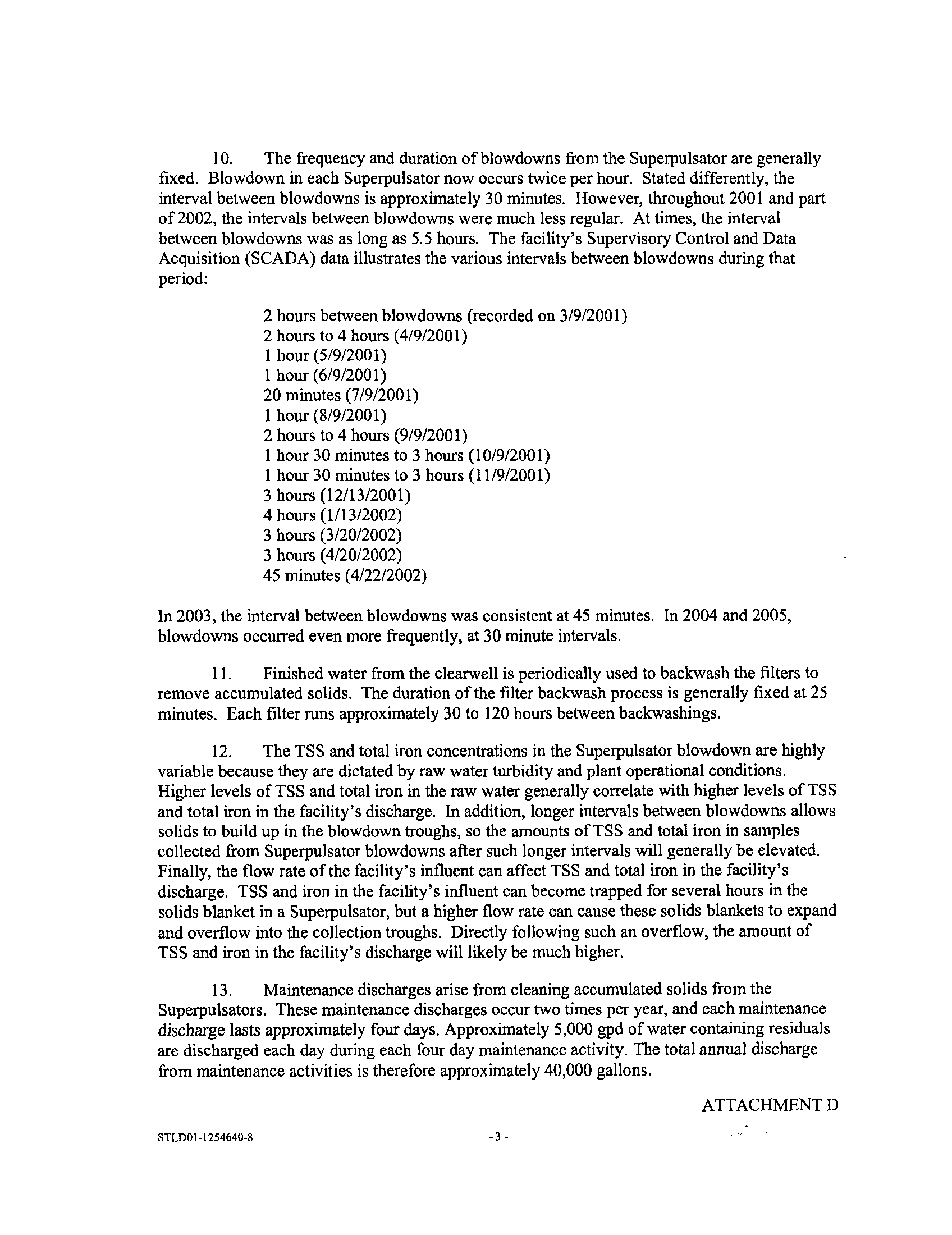
WATER COMPANY'S ALTON PUBLIC WATER
)
SUPPLY FACILITY DISCHARGE
)
TO THE MISSISSIPPI RIVER
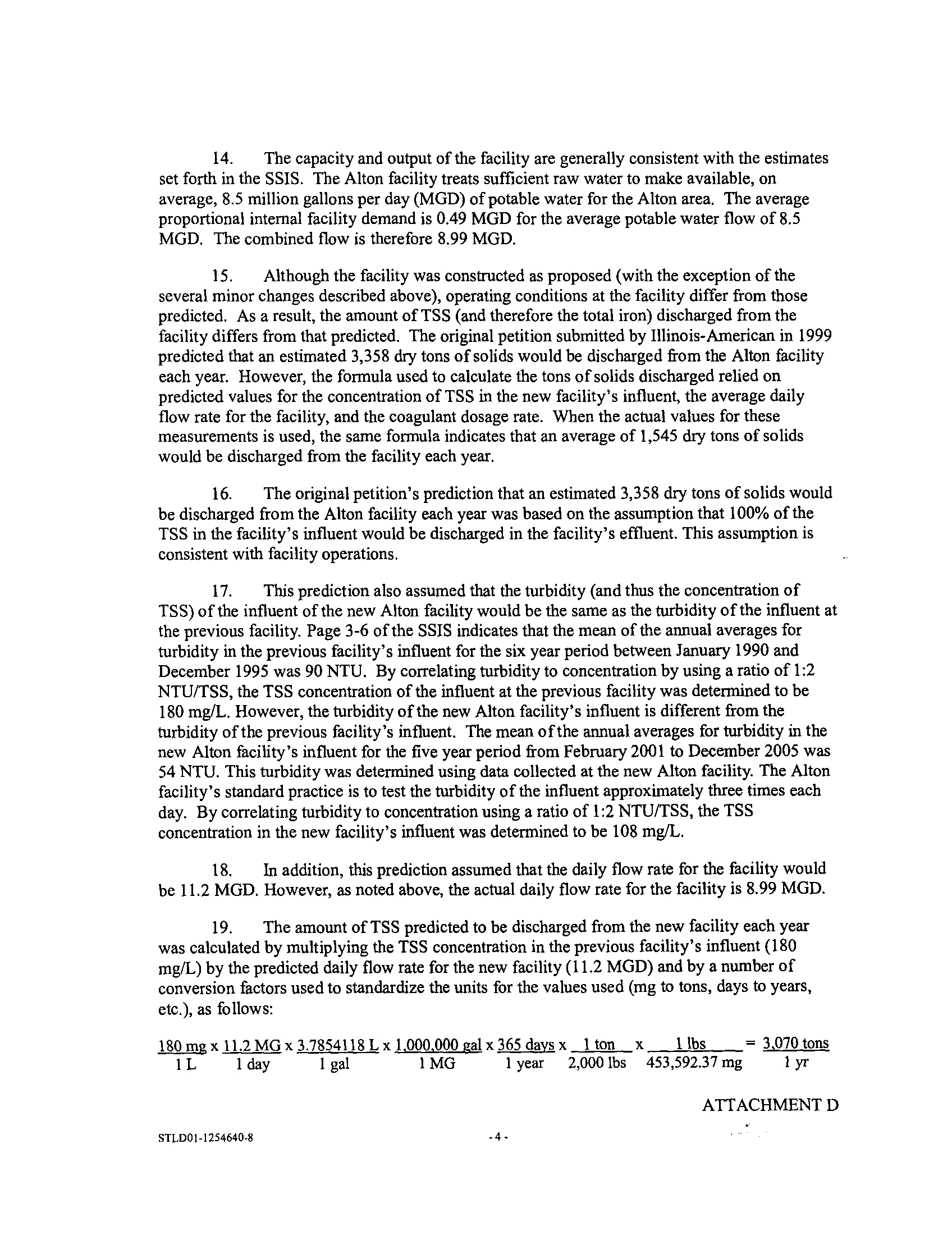
)
AFFIDAVIT OF ALLEY RINGHAUSEN
I, Alley Ringhausen, after being first duly sworn upon my oath, do depose and say as
follows:
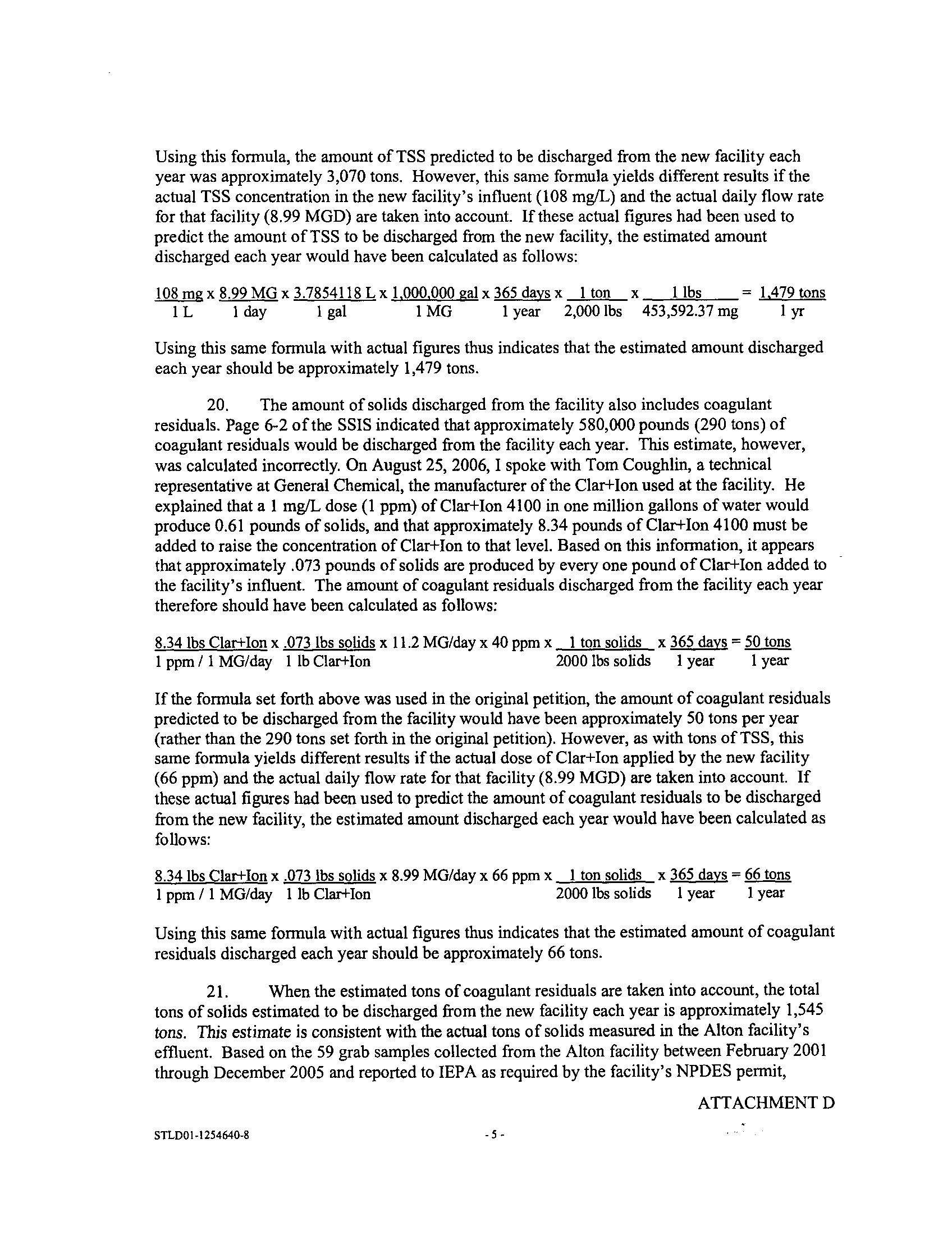
1.
I work at Great Rivers Land Preservation Association, Inc ., also known as Great
Rivers Land Trust ("GRLT"), where I hold the position of Executive Director. I am providing
this affidavit at the request of Brad Hiles, counsel to Illinois-American Water Company
("Illinois-American"), but I do so of my own free will. The statements in this
affidavit
are true
to the best of my knowledge, information and belief, and I am providing these statements under
oath. I would provide this same information in a hearing before the Illinois Pollution Control
Board ("IPCB"), if necessary, also under oath and penalty of perjury .
2.
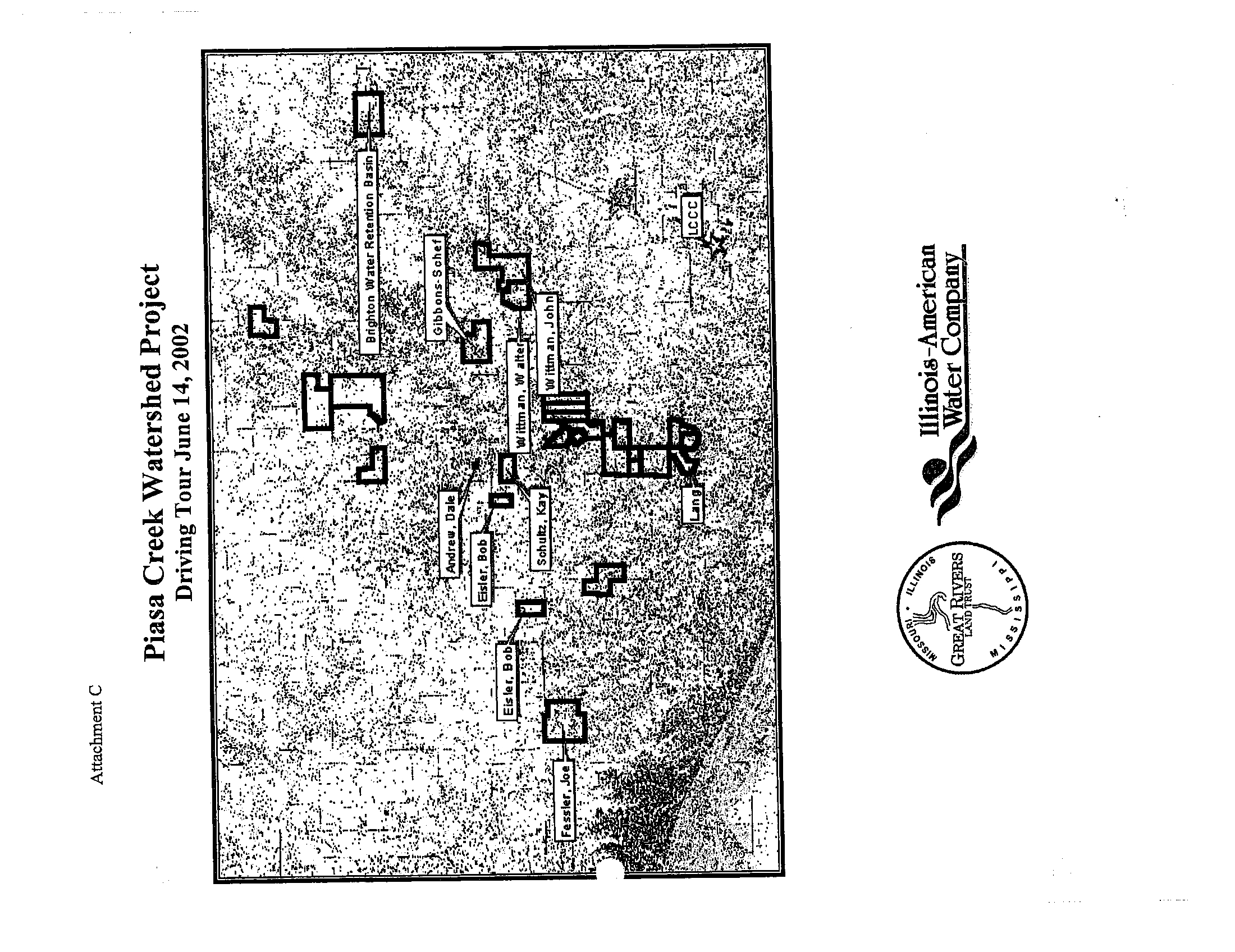
I am familiar with the Piasa Creek Watershed Project (the "Project"), which has
an objective of reducing sedimentation in the 78,000 acre Piasa Creek Watershed, located in
portions of Jersey, Madison, and Macoupin counties . In 2001, GRLT and Illinois-American
entered into an agreement to begin implementation of the Project, and the IPCB approved this
agreement . In return for providing funding for the ten-year life of the Project, Illinois-American
was granted a discharge permit by the Illinois Environmental Protection Agency ("IEPA").
3.
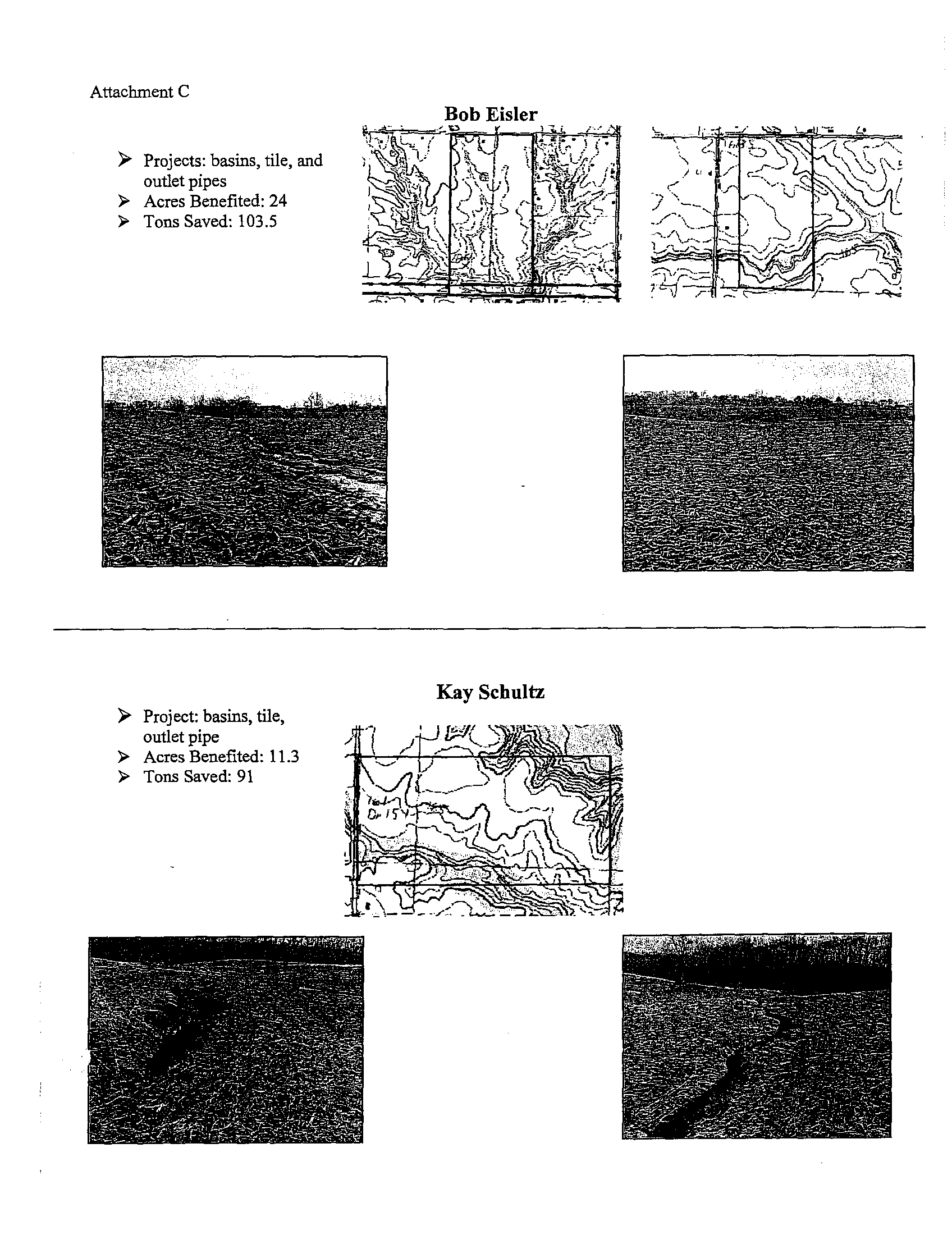
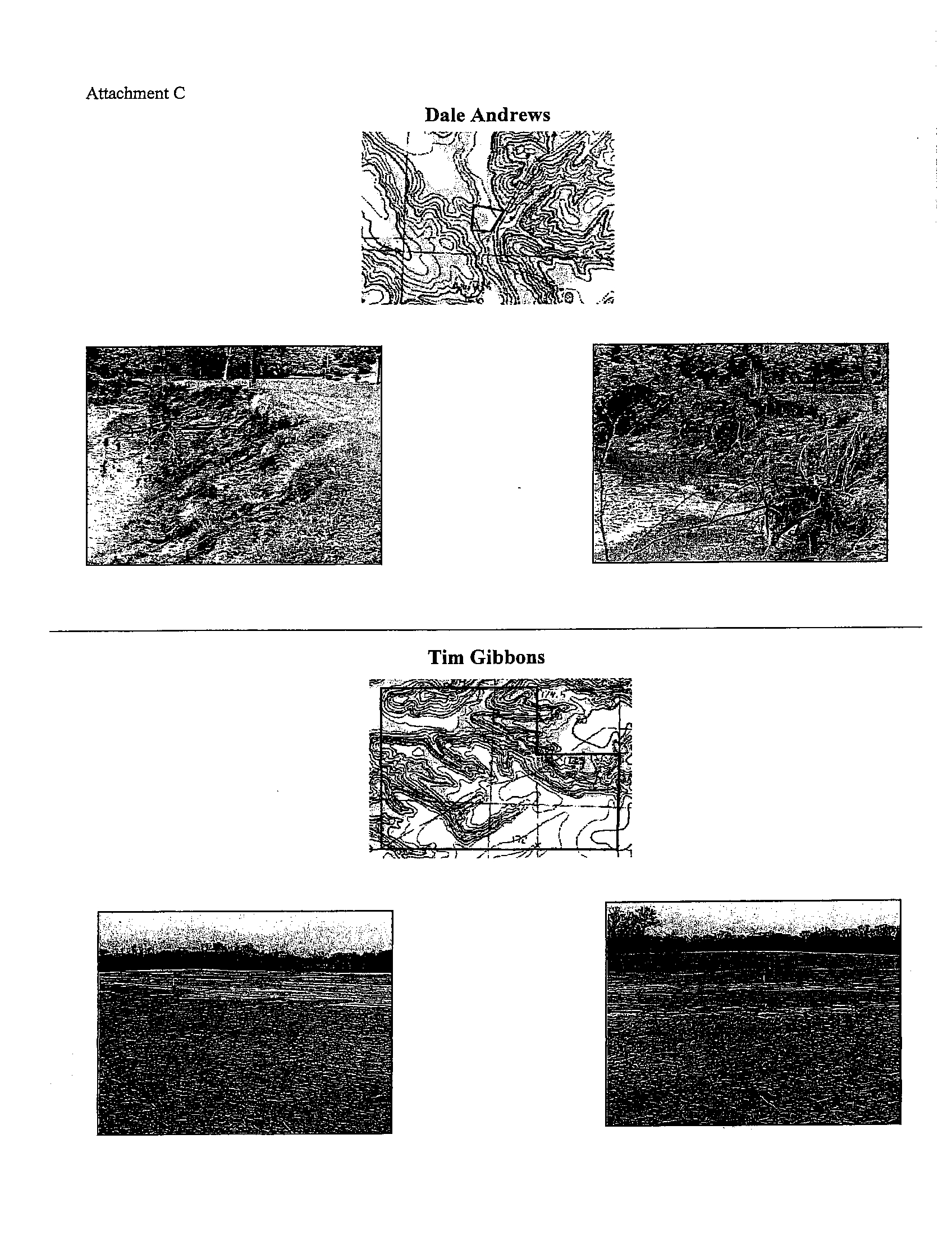
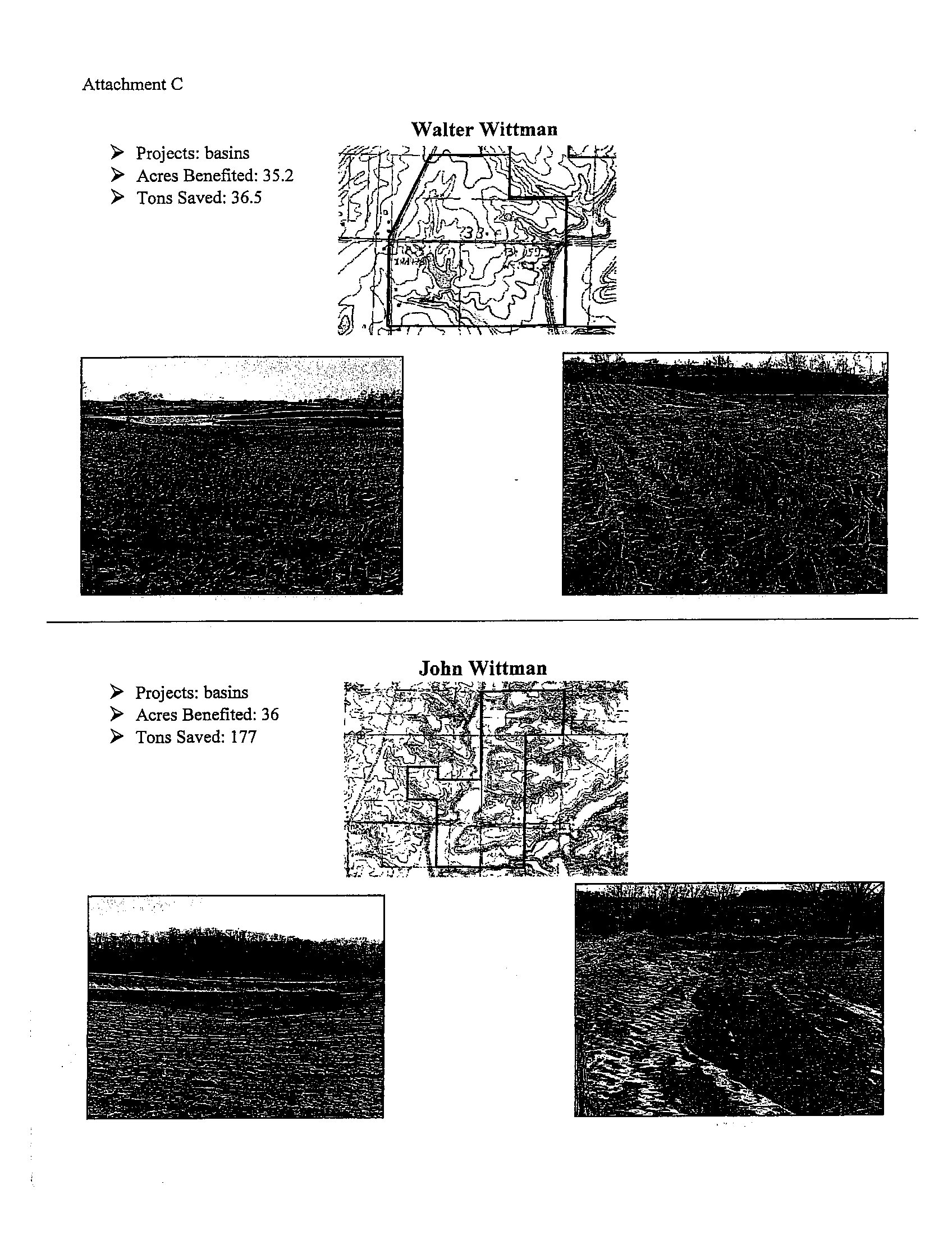
I am responsible for administering and implementing all aspects of the Project. To
implement the Project, I have helped GRLT construct rural sediment basins, retention basins, and
urban water detention/retention basins . I have also helped GRLT implement riparian treatment
measures including riparian corridor protection and restoration, streambank stabilization,
sedimentation reduction, and wetland restoration. In addition, I have helped GRLT purchase
property from willing sellers and establish conservation easements on property in a targeted area
along the riparian corridor of Piasa Creek. Finally, I have helped implement the Project by
working to educate area residents on the importance of watershed planning and how it affects
water quality, erosion, and storm water management and encouraging participation by area land
owners, farmers, community leaders, and other residents in the watershed .
4.
The Project's goal is to reduce sedimentation in the Piasa Creek Watershed by
approximately 6,600 tons of soil per year by the year 2010 . This annual offset of 2 :1 will
prevent two tons of soil from entering the Mississippi River for every one ton of Total
Suspended Solids that Illinois-American's Alton water treatment plant is anticipated to discharge
into the River each year.
STLDOI-1247363-9
ATTACHMENT A
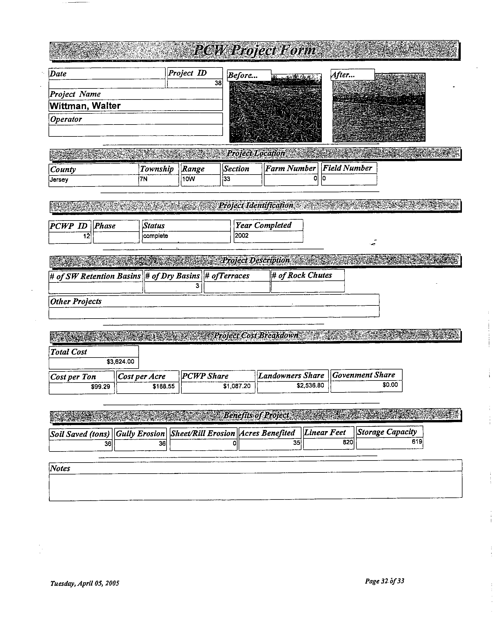
5 .
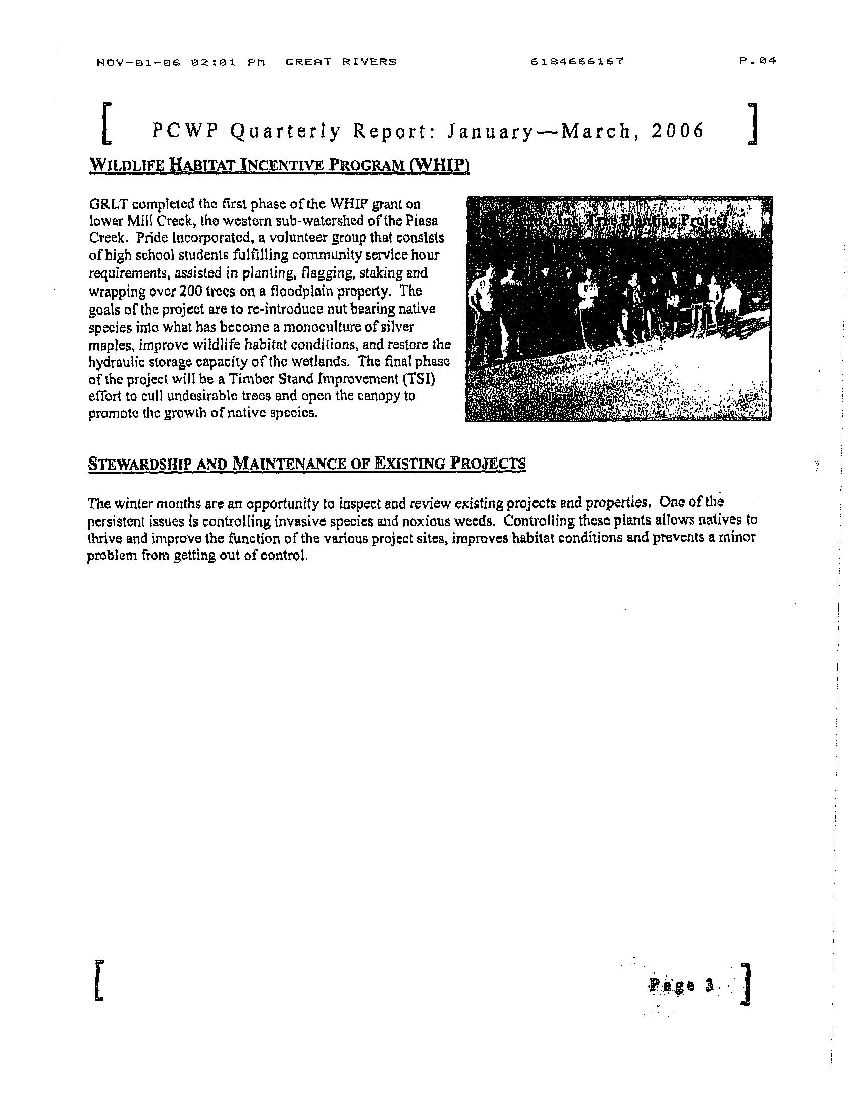
As of October 19, 2005, the Project had achieved a savings of approximately
6,487 tons of soil each year
. As of October 12, 2006, the Project has achieved a savings of
approximately 6,691 tons of soil each year
. Over 200 erosion reduction structures have been
completed on forty-two sites
. However, as part of the Project, GRLT is working on other active
and pending soil conservation projects that will benefit the Piasa Creek Watershed
. These
projects are at various stages of completion
. In addition, GRLT has received numerous requests
from nearby landowners interested in participating in the Project
. When the Project is completed
in 2010, my conservative estimate is that the Project will save approximately 10,000 tons of soil
each year. My hope, however, is that due to this increased interest in landowner participation
and the availability of supplemental funding sources, the Project will save 12,000 to 15,000 tons
of soil -
an amount that is approximately double the goal of 6,600 tons of soil saved
.
6.
The TSS reductions achieved by the Piasa Creek Watershed Project will repeat
year after year provided that certain stewardship activities are completed
. GRLT plans to develop
a strategy of long-term funding for stewardship of certain projects designed to control erosion
and trap sediment
. The TSS reductions achieved by the Project will be sustained above 6,600 if
these stewardship activities are performed on properties owned, leased or under cooperative
agreement with GRLT. Additional funding by Illinois-American will be required for some period
of time after the expiration of the ten-year agreement between Illinois-American and GRLT, but
the Project is expected to reach a point at which it will be sustainable without future funding
from outside sources. GRLT and Illinois-American are currently negotiating the terms of a
contract for maintenance.
7.
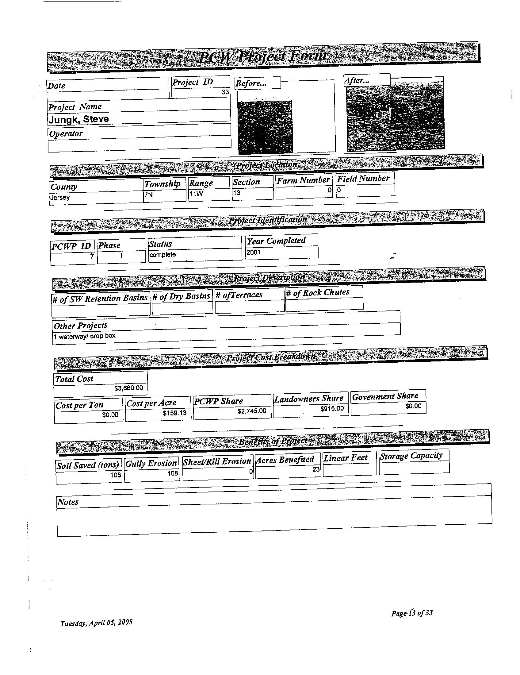
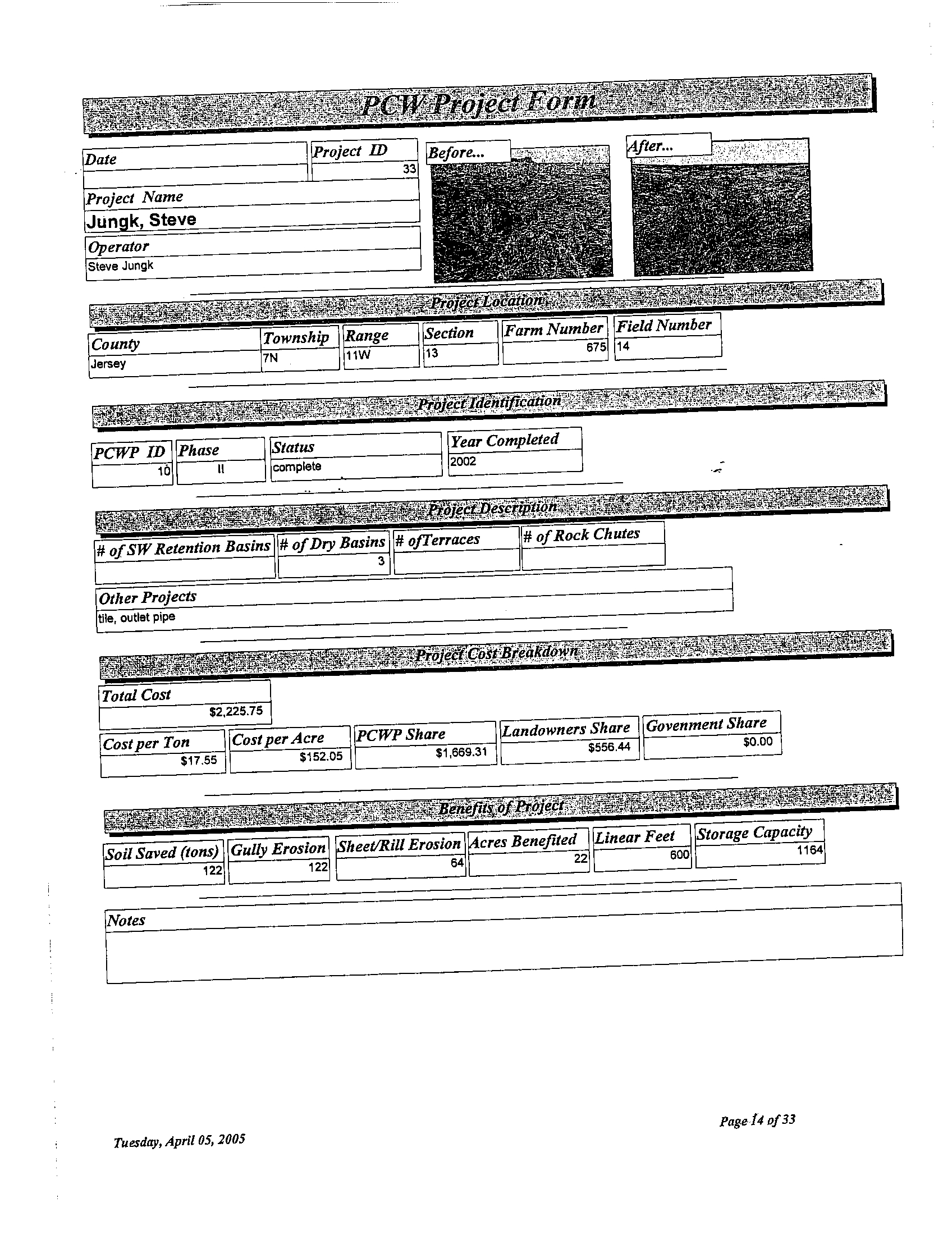
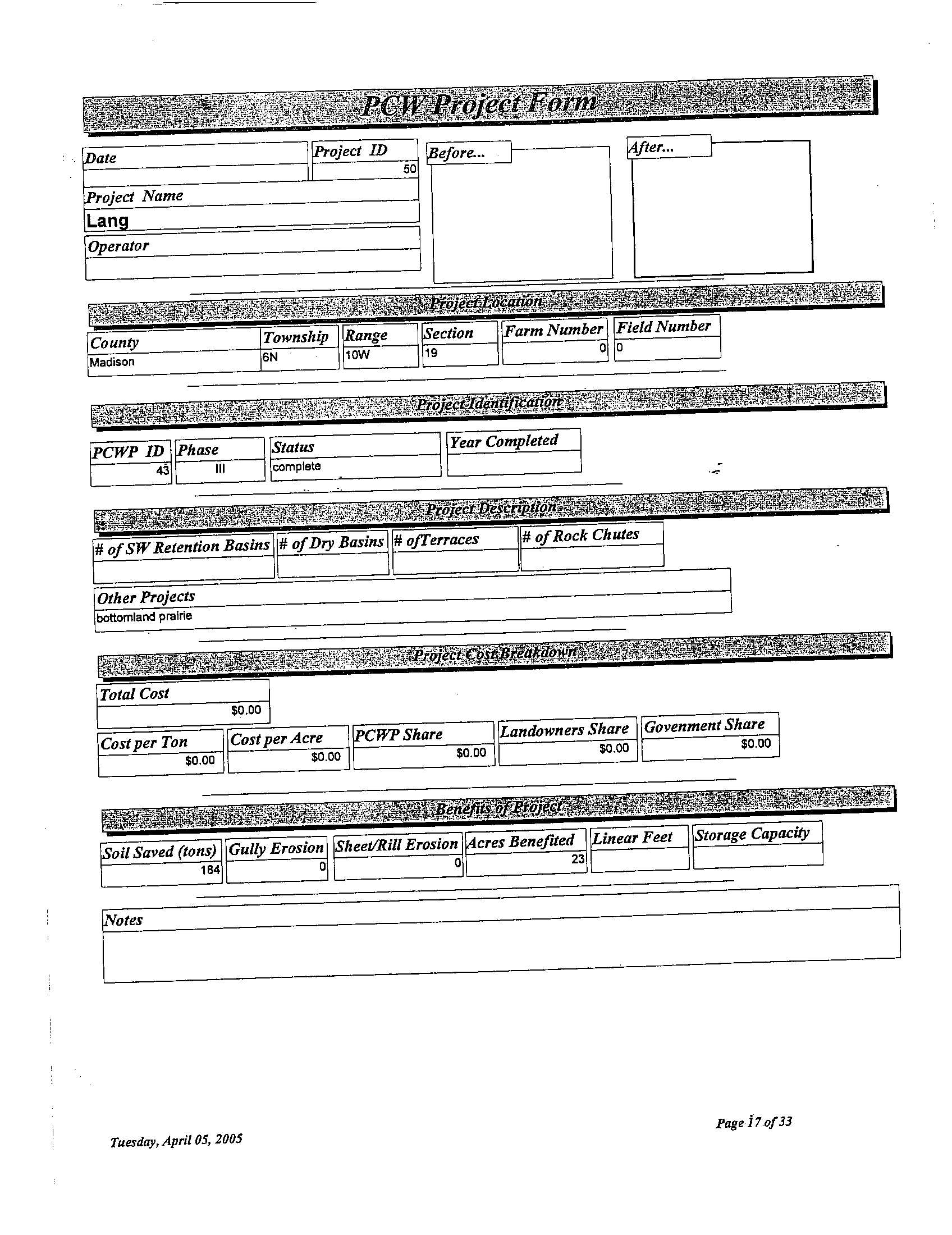
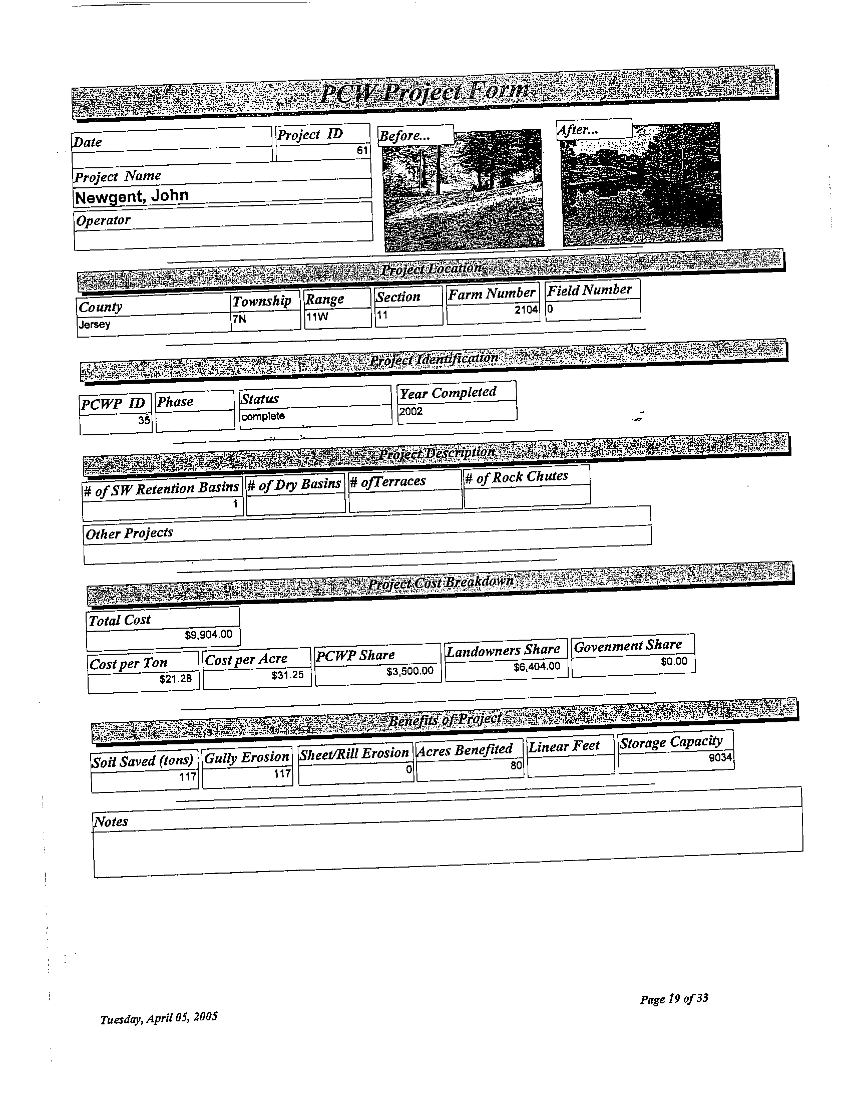
I prepared the Piasa Creek Watershed Project Report (the "PCWP Report")
attached to Illinois-American's Petition for Extension of Adjusted Standard as Attachment B
.
The PCWP Report contains information on the Project's background and goals, detailed
information on specific projects such as the Boy Scout Lake Project, the quarterly and annual
reports submitted to IEPA, and a chart summarizing the soil savings achieved by each individual
project. The PCWP Report is current through October 12, 2006
. However, it is an evolving
document that is updated as new information becomes available
. All numbers set forth in the
PCWP Report are based on calculations by the U
.S. Department of Agriculture (USDA) and are
consistent with industry standards
. The information contained in the PCWP Report is true and
accurate.
8 .
GRLT has received numerous awards in recognition of the Project's success
.
These awards include the Illinois Governor's Pollution Prevention Award for the Community
Group Category, which is awarded by the Illinois Waste Management and Research Center
("WMRC") and the Illinois Governor's office to one organization that has helped the
environment and the economy of Illinois by successfully reducing the generation of gaseous,
liquid, and solid waste; the Innovate Illinois Award, which is awarded each year by WMRC and
the Illinois Governor's office to one business or organization that has implemented a novel
technology or process modification that leads to significant waste reduction or elimination
; the
Illinois Buffer Partnership Award, which is awarded by Trees Forever to one business or
organization that has improved water quality and promoted land stewardship, as well as the
Trees Forever National Award for the Business/Education/Nonprofit Category, which is awarded
to one recipient of an award from a Trees Forever at the state level
; a National Resource
Conservation Service's Conservation Academy Award, which is awarded in recognition of
STLDOI-1247363-9
ATTACHMENT A
conservation-related achievements; a U .S . Department of Agriculture's Earth Team Volunteer
Program Award, which is awarded to organizations that achieve a certain level of volunteer
participation
; and one of three Soil and Water Conservation Society's National Merit Awards,
which are given in recognition of an outstanding project by an organization that promotes
conservation of soil, water, and related natural resources . GRLT has also received an award from
the National Parks Service identifying Rocky Fork, a stream in the Piasa Creek Watershed, as a
site that makes a significant contribution to an understanding of the underground railroad
; this
grant makes GRLT eligible for funding to preserve the lands around Rocky Fork .
9.
GRLT has also received numerous grants to implement the Project . Although
these grants are too numerous to list here, it is notable that GRLT is the only organization in
Illinois that has received a grant from Trees Forever in each year that such grant was offered .
10.
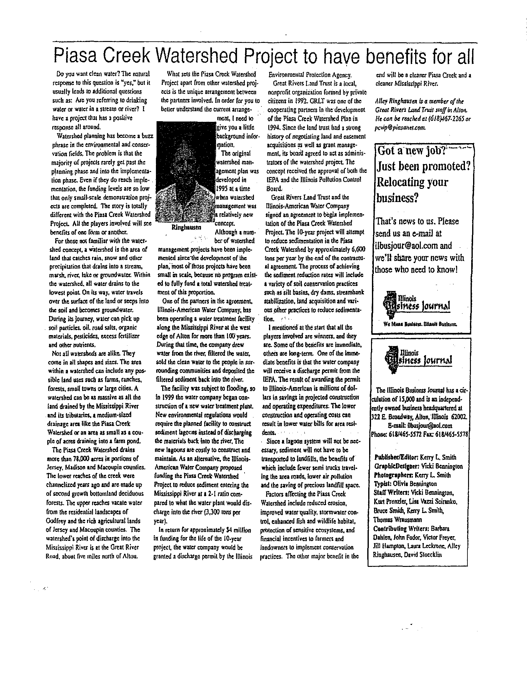
The Project has received considerable attention and acclaim nation-wide as a
result of its success. I have spoken about the Project at numerous nationwide and statewide
events . Notable nationwide events include the National Forum on Synergies Between Water
Quality Trading and Wetland Mitigation Banking (Washington,
D.C.), at which the Project was
presented as a model for water quality trading programs in the United States ; the Clean Water,
Livable Cities: Models That Work Conference (St . Louis, Missouri), hosted by the U .S. Army
Corps of Engineers and the U .S. Environmental Protection Agency ; the National Conference on
Nonpoint Source Pollution (Chicago, Illinois)
; the Land Trust Alliance Conference (Providence,
Rhode Island); the Upper Mississippi River Water Supplier Coalition (Moline, Illinois) ; and the
Mississippi to the Gulf Coalition (Memphis, Tennessee) . Notable statewide events include the
Illinois Watershed Conference ; the Illinois Department of Natural Resources Conservation
Conference ; the Illinois Landmark Preservation Council Statewide Conference; the University of
Illinois's Watershed Academy ; and the Illinois River Coordinating Council Conference
. In
addition, I have given presentations at various colleges and universities, including Southern
Illinois University (Edwardsville); Principia College; University of Missouri (St . Louis);
Southern Illinois University (Carbondale) ; and Lewis & Clark Community College . I and other
individuals responsible for implementation of the Project have also given presentations to an
extensive list of local goups. Finally, articles about the Project have appeared in a number of
national journals and publications, several regional publications, and numerous newspapers, and
the Project has been the subject of over a dozen technical papers and theses .
11 .
I graduated with honors from Southern Illinois University (Edwardsville), where I
received a master's degree in Environmental Studies. I specialized in Watershed Management
.
12.
I am familiar with the report titled Site-Specific Analysis of Impacts of Potential
Alternatives for Handling Public Water Supply Residuals at Proposed Alton, IL Facility, which
was prepared by ENSR in March 1999 (the "Site Specific Impact Study" or "SSIS") . To my
knowledge, the SSIS accurately reflects the conditions present in the Mississippi River (the
"River") near River Mile 204 at the time that study was prepared .
13.
As the individual responsible for administering and implementing the Project, I
am required to regularly observe and monitor the quality of water and of habitats in the Piasa
Creek Watershed. I spend approximately four (4) days each week doing field work in the
Watershed. My observations have given me no reason to believe that the TSS concentrations
STLDOI-1247363-9
ATTACHMENT A
State of Illinois
)
ss
County of Madison )
Subscribed and sworn to before me this
My Commission Expires :
[SEAL]
STLDOI-1247363-9
and turbidity in the Mississippi River have deteriorated since the Site Specific Impact Study was
prepared in 1999
. Rather, these conditions appear to have improved since that time .
14.
The Project has met and exceeded all of its goals to date . Interest and
participation in the Project has been embraced on a local, regional, and national scale
. Private
foundations, governmental entities, service organizations, and even individuals have partnered in
some way to assist in the success of the Project . From the environmental perspective, the Project
has done exactly what it was intended to do - to reduce sediment input into the Mississippi
River. The Project's positive effects go far beyond the innovate water quality trading aspect
;
benefits of the Project include reduced erosion, improved water quality, stormwater control,
reduction of flash flooding, enhanced fish and wildlife habitat, protection of sensitive
ecosystems, public education on watershed management, and financial incentives to farmers and
landowners to implement conservation practices
. On behalf of Great Rivers Land Trust, I
strongly support Illinois-American's petition for an extension of Adjusted S
99-6
Further, Affiant sayeth not
.
3/
da of October, 2006.
IGGZr
Notary Public
..°f
"OFFICIAL SEAL"
Pamela S
. Cunningham
Notary Public, State of Illinois
My Commission Exp
. 03/14/2009
ATTACHMENT A
PwA
CREEK'
WATERSHED PROJECT
Illinois
American Water
RWE GROUP
I.
PCWP Implementation Plan
II. 2001 Reports
III. 2002 Reports
IV. 2003 Reports
V. 2004 Reports
VI. Boy Scout Lake Project
®
VII. Project Files
VIII. Press Releases
IX
. Maps
Piasa Creek
Watershed
Project
-Q;%, American
Illinois
Water
RW E
rp
TABLE OF CONTENTS
H
U
W
O
U,
z
0
gel
d H
w
U
Q
Q
Piasa Creek Watershed Project
Implementation Plan
March 2004
TOPOGRAPHY
5
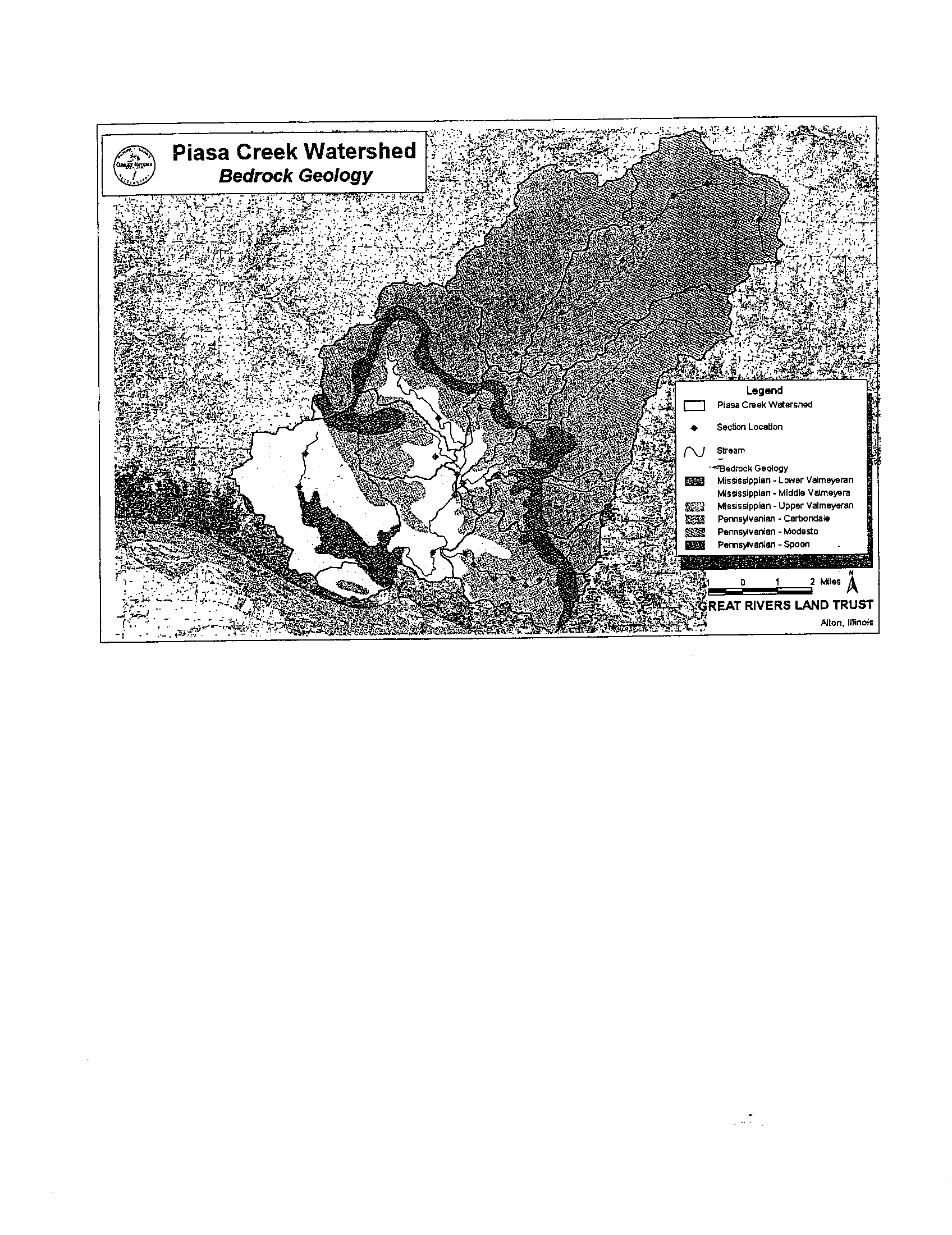
GEOLOGY (BEDROCK AND QUATERNARY)
5
4. SEDIMENT REDUCTION PROJECT PLAN 11
UPLAND TREATMENTS
11
SOILS
6
CLIMATE
6
LAND COVER
6
VEGETATION AND WETLANDS
7
AGRICULTURAL LANDS
7
FORESTS
7
WETLANDS
6
SEDIMENTATION
.
.
. .. ..
...
...
.. ...
.
... .. ... .. ..... . .. ... ... .. ... .. . .. ..... .. . .... 6
Table of Contents
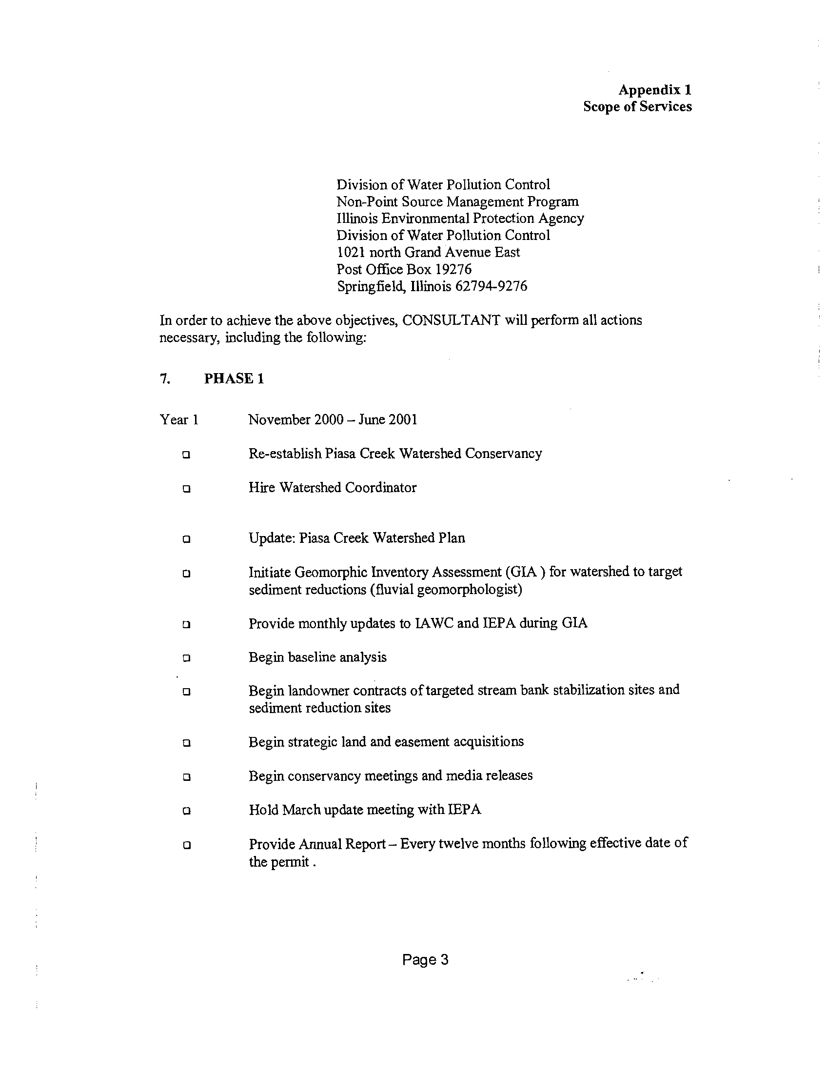
1 . PROJECT BACKGROUND
1
THE ALTON WATER TREATMENT FACILITY & SOLIDS TRADING 1
THE PIASA CREEK WATERSHED
2
2.
GREAT RIVERS LAND TRUST & THE ORIGINAL WATERSHED PLAN 2
PROJECT GOALS, PLAN AND BENEFITS 3
PROJECT GOAL
3
PROJECT PLAN
4
PROJECT BENEFITS
4
3. CURRENT WATERSHED CONDITIONS 5
Piasa Creek Watershed Project
Implementation Plan
March 2004
RIPARIAN TREATMENT
13
SEDIMENT REDUCTION PROJECT SUMMARY 18
4. SEDIMENT REDUCTION MONITORING AND EVALUATION
. ..
.19
5. STORMWATER ORDINANCE DEVELOPMENT 22
6. EDUCATION AND PUBLIC AWARENESS PROGRAMS 23
TOURS
23
PRESS
24
PIASA CREEK WATERSHED EDUCATION TEAM PROJECT 25
PRESENTATIONS
26
1 .
Project Background
The Alton Water Treatment Facility & Solids Tradinq
Illinois American Water (IAW) constructed a new 16
.0 million gallon per day
(mgd) water treatment facility in Alton, Illinois to replace a 100-year old facility
that was susceptible to flooding . The old Alton Water Treatment Facility had site
specific exemption as part of its National Pollutant Discharge Elimination System
(NPDES) Permit for the direct discharge of residual solids and backwash water to
the Mississippi River . The Illinois Environmental Protection Agency (IEPA)
determined that the existing site specific exemption and NPDES Permit did not
apply to the new facility and that standard discharge limits would apply unless
new regulatory relief was granted. Ninety-one percent (91%) of the waste stream
from the new facility is silt removed from the raw water and the other nine
percent (9%) is inert residual coagulants utilized in the treatment process
.
Although a Site Specific Impact Study showed that a direct discharge would not
adversely affect the Mississippi River, IEPA did not initially support the concept of
an Adjusted Standard application for the new Alton Water Treatment Facility
.
IAW continued to pursue the Adjusted Standard application because a direct
discharge would eliminate the need for residuals lagoons, mechanical dewatering
equipment and hauling the dewatered solids to a landfill . In addition to increased
capital ($7 .4 million) and O&M costs ($0 .42 million/year) associated with
dewatering, it was estimated that three (3) to seventeen (17) trucks per day
would be required to haul the dewatered solids from the facility along the Great
River Road to a landfill site . Local residents, government officials and
environmental groups were opposed to the siting of lagoons and the hauling of
de-watered solids along this roadway, which was recently established as a
National Scenic Byway.
IAW developed a unique partnership with the Great Rivers Land Trust (GRLT) to
implement a watershed project, which will provide a sustainable reduction in
overall sediment loading of the Mississippi River . IAW will contribute $4
.15
million over a ten (10)-year period to fund the Piasa Creek Watershed Project
.
The project is expected to obtain a 2
:1 reduction in sediment load to the
Mississippi River as compared to the direct discharge load (9 .2 dry tons/day)
from the new Alton Water Treatment Facility
. IAW amended its Adjusted
Standard application to include this unique suspended solids trading proposal
.
IEPA supported the amended application and the IPCB issued the adjusted
standard AS 99-6
. An NPDES Permit incorporating the terms of AS 99-6 was
issued to allow IAW to start-up the new facility to meet a December 31, 2000
deadline .
Piasa Creek Watershed Project
Implementation Plan
March 2004
Page 1
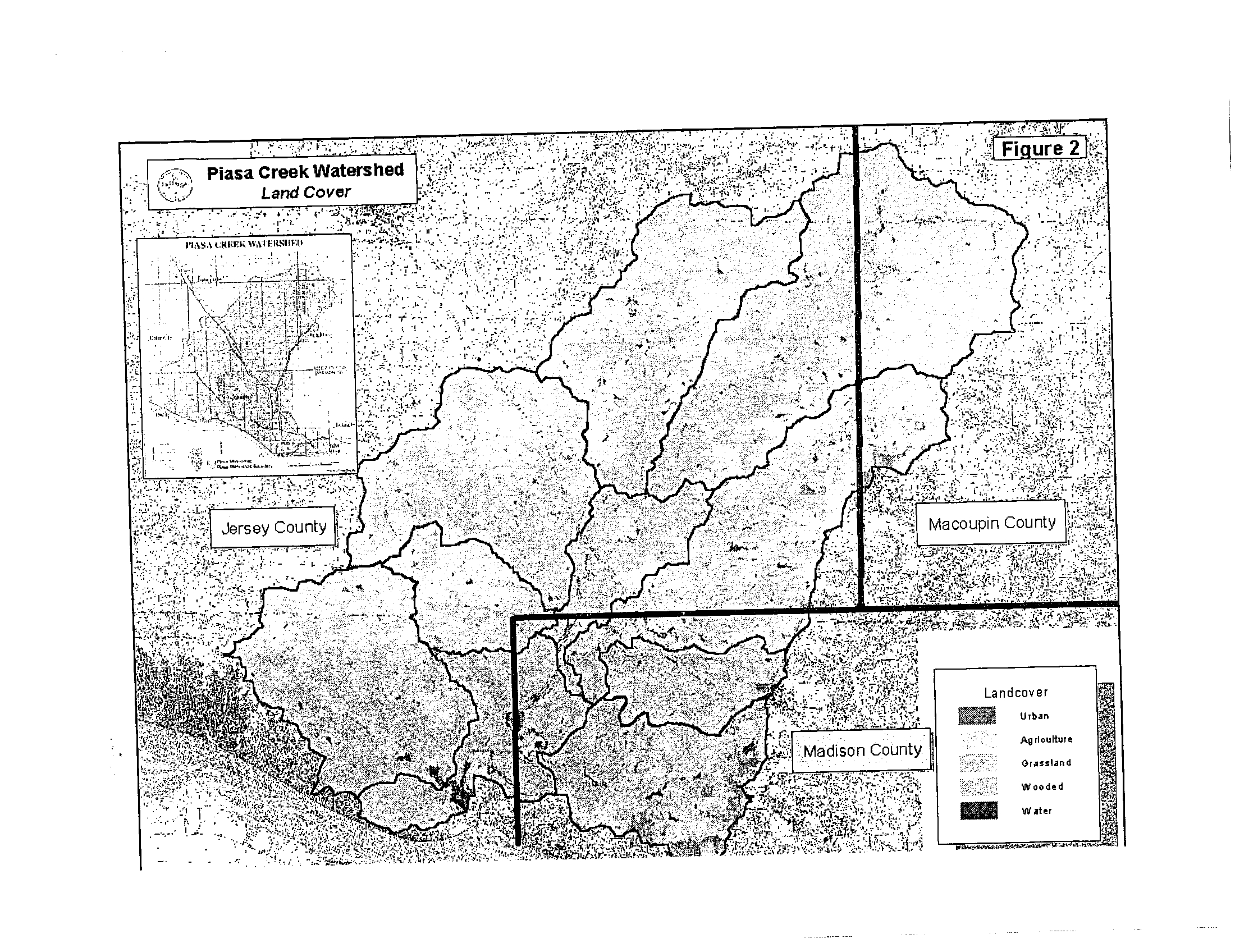
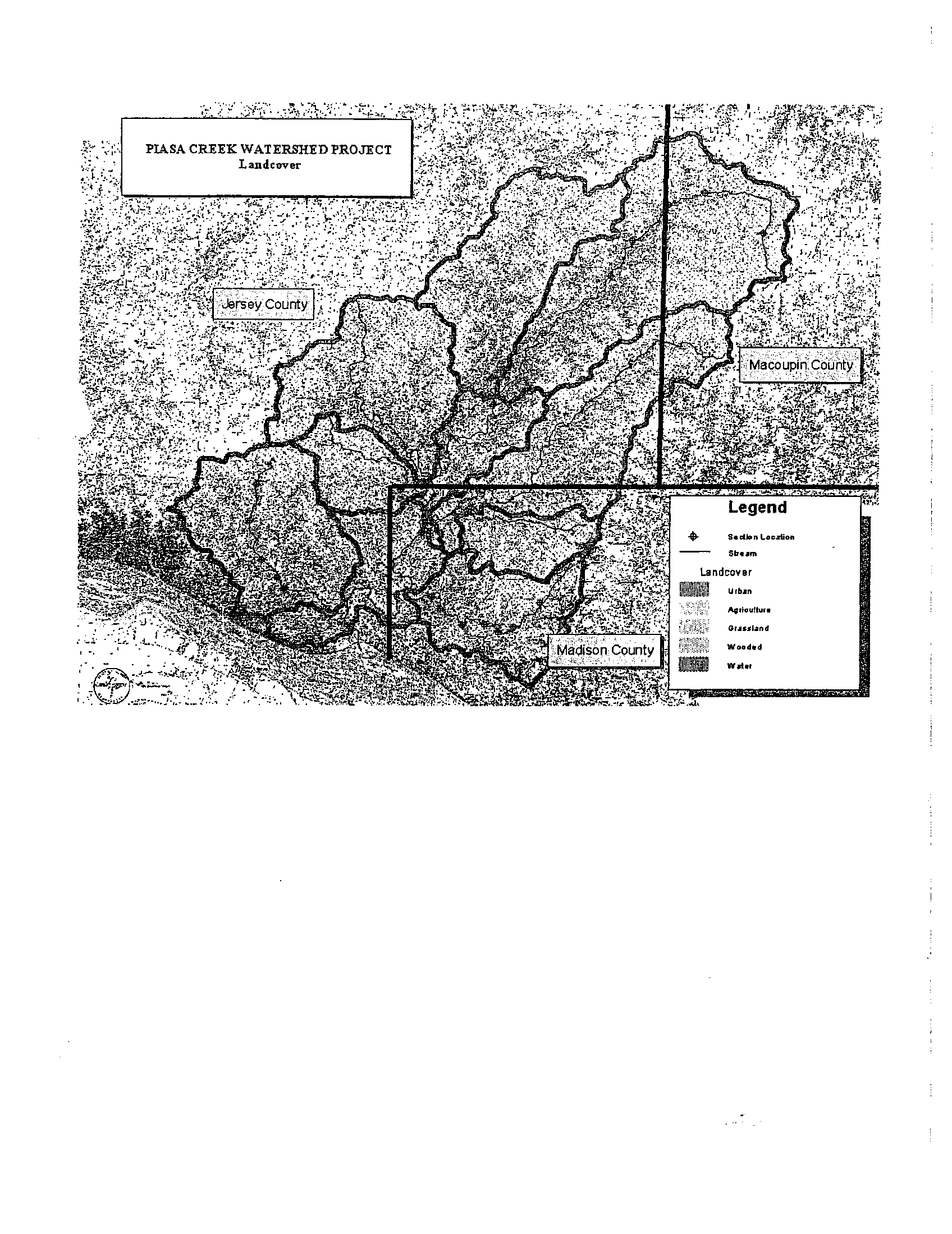
The Piasa Creek Watershed
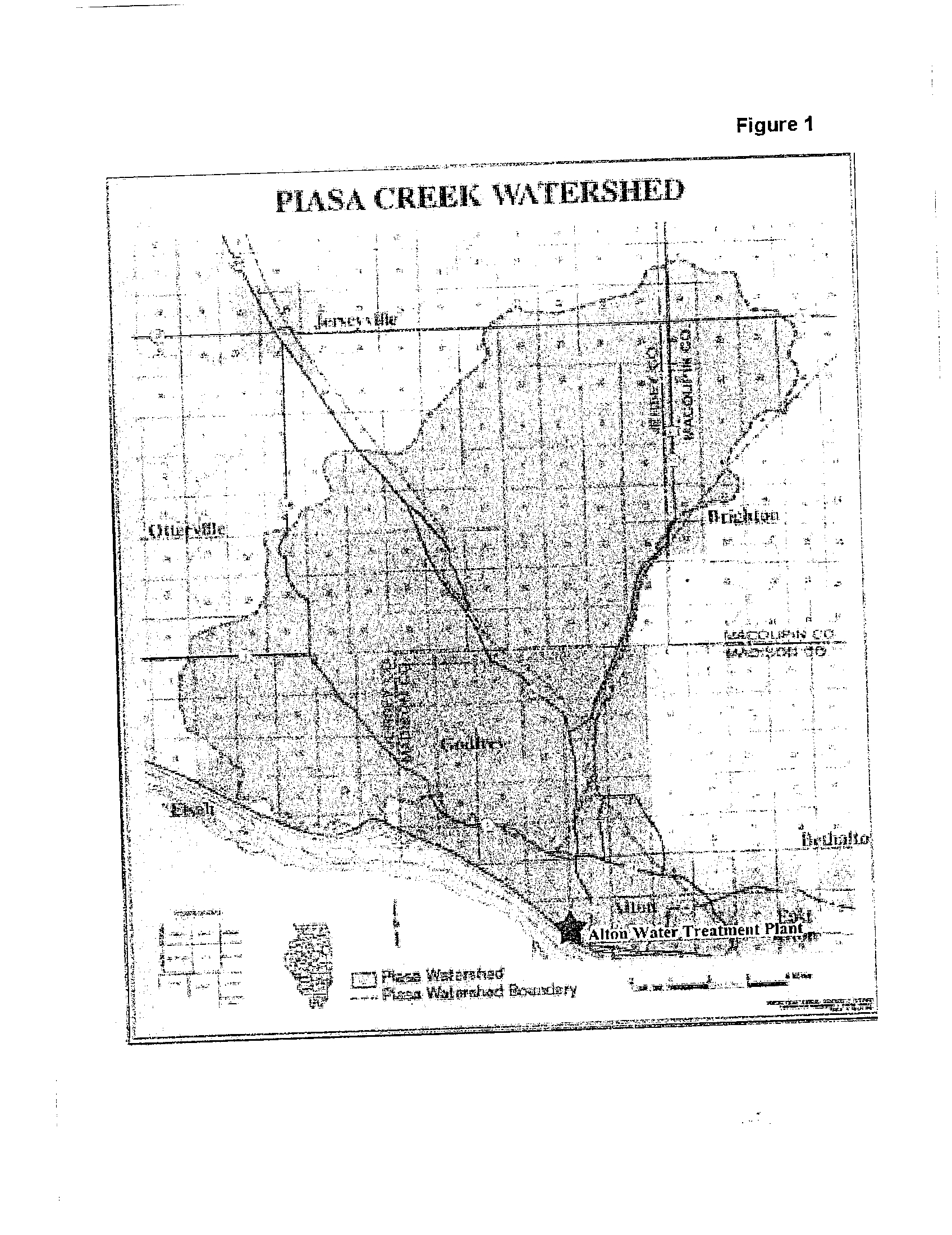
The Piasa Creek Watershed covers approximately 78,000 acres, or 121 .9 square
miles, in portions of Jersey, Madison and Macoupin Counties (Figure 1, Figure
2) . Almost the entire Macoupin County portion of the watershed (12%) is
devoted to intense agricultural practices . The Jersey County portion of the
watershed (62%) is predominantly intense agriculture with the exception of areas
of steeper topography and stream corridor, which are primarily grasslands and
forest cover . The Madison County portion of the watershed (26%) is the only
segment with any significant urban population . The landscape in the Madison
County section all falls within the boundaries of Godfrey
. The agricultural and
forested areas of Godfrey are rapidly being replaced by subdivisions and
commercial development.
As the result of years of hydraulic modification and increased
drainage, Piasa
Creek's natural ability to absorb flood waters, trap sediment or control erosion
are greatly diminished
. Alterations to the watershed hydrology from landscape
modifications coupled with the region's highly erodible loess soils and steep
topographic gradients have increased the magnitude and
frequency of flash
flooding
. The instability of the unconsolidated streambanks has dramatically
increased the sediment load of the water column .
The most pervasive problem
in the upper reaches is runoff from agricultural fields and urban landscapes .
There are no known permitted point source discharges
present within the Piasa
Creek Watershed
.
Great Rivers Land Trust & The Oriqinal Watershed Plan
GRLT is a local non-profit organization formed by private citizens in 1992
. GRLT
was one of the cooperating partners in the development of the original Piasa
Creek Watershed Project in 1994.
In the summer of 1994, GRLT held a series of exploratory meetings
to discuss
possible solutions to water quality and flood related problems in the Piasa Creek
Watershed. Although the Piasa Creek Watershed is impacted
heavily by both
urban and rural land uses, the local groups felt the need
for assistance in
addressing problems stemming from the agricultural sector . With funding from
the McKnight Foundation, GRLT agreed to apply limited
staff and financial
resources to a one-year program for the purpose of working with members of the
agricultural community to address environmental issues
in the Piasa Watershed
in a cooperative, pro-active way
.
Piasa Creek Watershed Project
Implementation Plan
March 2004
Page 2
Using a process developed by the Natural Resource Conservation
Service
(NRCS) known as "resource planning", farmers, landowners and urban residents
met to identify resource concerns and discuss possible solutions .
After several meetings using the nominal group process to identify concerns,
some common themes emerged . Farmers and rural landowners were concerned
about soil erosion and runoff from agricultural lands, but they also viewed urban
pollution and encroaching land uses as equally serious threats to environmental
quality in the watershed . They acknowledged that some flooding might be
attributed to agricultural drainage and hydrologic modification
on rural lands, but
they felt that urban build-up and a lack of stormwater handling facilities in
residential areas greatly contributed to flood-related problems .
Based on these concerns, members of the Piasa Creek Watershed Partnership
steering committee, serving as facilitators for the
meeting process, made the
decision to focus the discussion regarding potential solutions on three main
subject areas : 1) soil erosion, 2) water quality and 3) urban issues
.
Recommendations for solutions to address these problem
areas were also listed,
combined, and ranked using the nominal group process .
The original watershed management plan was finally developed in late 1995 at a
time when watershed management was a relatively new concept
. Although a
number of watershed management projects have been implemented since the
development of the plan, most of those projects have been small in scale,
because no program existed to fully fund a total watershed
treatment of this
proportion .
The $4 .15 million grant from IAW provides the funding resources to resurrect the
Piasa Creek Watershed Project and provide the seed for other funding sources .
IAW and GRLT fully expect the new Piasa Creek Watershed
Project will provide
the sediment reductions required to fulfill the NPDES permit suspended solids
trading requirements .
2.
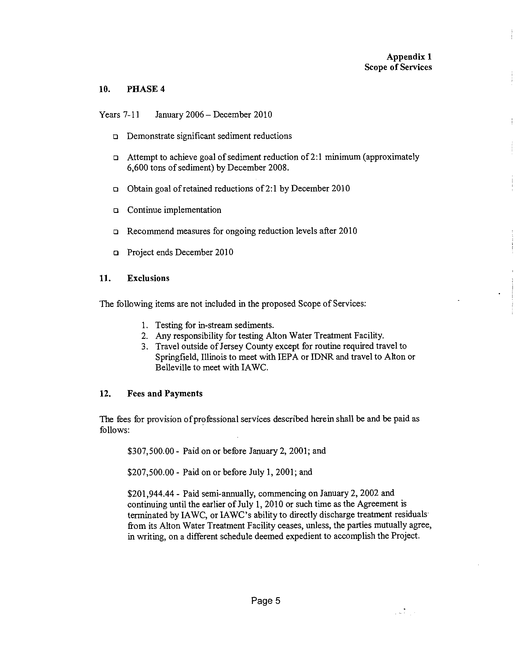
Project Goals, Plan and Benefits
Project Goal
The Piasa Creek Watershed Project will reduce sedimentation in the watershed
by approximately 6,700 tons per year by the end of the ten-year
program in 2010 .
Page 3
Piasa Creek Watershed Project
Implementation Plan
March 2004
Pro ect Plan
The basic project plan is elaborated in the Agreement between IAW and GRLT
and in IEPA's NPDES Permit, which are both included in
Appendix A . In
summary, the project plan includes :
•
Year 1 (2001)
•
Employ Watershed Coordinator
•
Initiate Geomorphic Inventory Assessment (GIA)
•
Initiate watershed stakeholder contacts
•
Years 2-5 (2002-2005)
•
Submit Watershed Assessment Report & GIA within 24 months
after the effective date of the NPDES Permit (1/24/03) .
•
Submit Watershed Implementation Plan within 30 months after
effective date of the NPDES Permit (7/24/03)
•
Implement recommendations within 36 months after effective
date of the NPDES Permit (1/24/04)
•
Address storm water ordinances in Godfrey
•
Monitor sediment reduction
•
Work to attract additional funding
•
Submit comprehensive assessment of the project status
180
days prior to expiration of the NPDES permit (7/24/05) to
determine project viability for 5 more years
.
•
Years 6-10 (2006-2010)
•
Continue implementation
•
Monitor sediment reduction
•
Obtain 2 :1 reduction goal (6,700 tons) by 12/31/08
•
Complete project-12/31/10
•
All Years
•
Quarterly reporting to IAW and IEPA
•
Yearly meeting with IEPA
Project Benefits
There are multiple benefits beyond the sediment reduction
goal. Some of the
benefits are immediate, while others are long term .
One of the immediate benefits is that the water company
received an NPDES
permit from the IEPA allowing direct discharge to the
Mississippi River . The
result of awarding the permit to IAW is millions of dollars in savings in projected
construction and operating expenditures
. The lower construction and operating
costs can result in lower water bills for area residents . Since a lagoon system
Page 4
Piasa Creek Watershed Project
Implementation Plan
March 2004
will not be necessary, sediment will not have to be transported to landfills, the
benefits of which include : fewer semi trucks traveling area roads, lower air
pollution, and saving of precious landfill space .
Factors effecting the Piasa Creek Watershed include reduced erosion, improved
water quality, stormwater control, enhanced fish and wildlife habitat, protection of
sensitive ecosystems, and financial incentives to farmers and landowners to
implement conservation practices . The other major benefit in the end will be a
cleaner Piasa Creek and a cleaner Mississippi River .
3.
Current Watershed Conditions
GRLT secured the services of Shannon-Wilson, Inc . to conduct a Geomorphic
Inventory Assessment (GIA) of the Piasa Creek Watershed . The GIA provides
an assessment of the current geomorphology of the watershed and provides
recommendations for reducing sediment load in Piasa Creek and ultimately the
Mississippi River. The final report was published in October 2002 and is included
in Appendix B . The following section serves to summarize the GIA findings .
Topography
Elevations in the Piasa Creek Watershed ranged from a low of 430 feet National
Geodetic Vertical Datum (NGVD) at the mouth of Piasa Creek to a high of 740
feet NGVD on the bluffs along the Mississippi River . Elevations near the
headwaters of Piasa Creek were approximately 660 feet NGVD .
Slope classifications include : 0-5% slope, 5-20% slope, 20-40% slope, and 40-
100% slopes . GIA Table I presents the total and percent area of each slope
classification within the watershed . Slope classifications were calculated from
30-meter USGS Digital Elevation Models (DEM) of the watershed
.
Geology (Bedrock and Quaternary)
Mapping of the bedrock units within the watershed has been accomplished by
the Illinois State Geological Survey and is presented in the 'Geological Map of
Illinois' (Willman et . al., 1967). Six bedrock formations were identified within the
watershed . Descriptions of the bedrock formations were obtained from the
Handbook of Illinois Stratigraphy (Willman and et . al ., Illinois State Geological
Survey, 1975). GIA Table 1 presents a summary of the total and percent area of
the bedrock. units
. Predominant bedrock deposits include : Mississippian-Upper,
Middle, and Lower Valmeveran, Pennsylvanian-Spoon and Carbondale
Formations, and Pennsylvanian-Modesto Formation .
Piasa Creek Watershed Project
Implementation Plan
March 2004
Page 5
Piasa Creek Watershed Project
Implementation Plan
March 2004
Information for the Quaternary deposits within the watershed was derived from
the `Quaternary Deposits of Illinois Map' (Lineback,
1979), published by the
Illinois State Geological Survey . GIA Table 1 summarizes the total and percent
area of the Quaternary deposits within the Piasa Creek watershed
.
The three
predominant deposits included : Cahokia Alluvium, Peoria Loess and Roxana
Silt, and Vandalia Till Member of Glasford Formation .
Soils
The U .S
. Department of Agriculture (USDA) Natural Resources Conservation
Service, (NRCS)j, has mapped the distribution of soil
types in the Piasa Creek
watershed
. Composite maps of soil types were developed for each county in the
watershed, based on the NRCS soil surveys . Four predominant soil associations
have been identified in the watershed
. These soil associations were designated
by the NRCS based on similar soil characteristics, including parent material,
slope, and drainage . The percent coverage of these soil
associations in each
subbasin is presented in Table 1 of the GIA. The predominant soils associations
and their percentages of coverage in the watershed are as follows :
Clinton-
Keomah Association (45%), Favette-Stringhurst Association (23%), Bottomland,
and Terrace Association, (17%), and
Tama-Muscatine/Harrison-Herrick
Association (15%) .
Climate
The Piasa Creek watershed lies within an area that is characterized by an interior
continental climate . As such, weather is influenced by the Gulf of Mexico, Pacific
Ocean and the Arctic Ocean, depending on the season . Precipitation events in
the spring and summer months tend to be of short duration
and high intensity .
Precipitation events in the fall and winter months are generally of long duration,
frequently lasting several days, but of relatively low intensity .
According to the National Oceanic and Atmospheric Administration,
average
monthly temperatures in the study area are 28
.8° in January, 56 .1° in April, 78 .9°
in July, and 57 .9° in October . Average annual precipitation between 1990 and
2000 was 37 .37 inches
. GIA Table 2 presents a summary of monthly rainfall
between 1990 and 2000.
Land Cover
Land cover, shown in figure 2, is grouped into five general
categories : Urban land
cover (3.9%),
agricultural land cover (48 .1%), grassland land cover
(17.2%),
wooded land cover (28 .7%), and water land cover (2%) .
The further details of
each of these land cover types in each subbasin are presented in GIA Table 1
.
Page 6
Vegetation and Wetlands
Vegetation and habitat were varied within the Piasa Creek Watershed . Very little
pre-European-settlement vegetation remained, but pockets of relatively
undisturbed habitat existed along sections of Piasa Creek . Forest loss can play
a significant role in bank stability and ecosystem health . Vegetation, particularly
forests provide shade and thus keep water temperatures cooler. Forests also
provide organic matter, and contribute woody debris for use as habitat cover .
The roots of vegetation will help stabilize channel banks .
Agricultural Lands
The majority of the land cover within the watershed was in agricultural
production . Many of the bottomland areas adjacent to Piasa Creek and its sub-
basins have been cleared, and have been used for row-crop production .
Similarly, the flat to gently rolling uplands have been cleared of forest and prairie
cover and converted to row-crop production . Row crops produced were primarily
corn, soybeans, and winter wheat . Some pasture was located on areas of rolling
topography . Pasture areas and grassland consisted primarily of fescue . Only
small pockets of native grassland were present within the Piasa Creek
watershed, primarily in upland areas . Most grassland areas were either pasture
or suburban lawns . In addition, only a few orchards were present in the
watershed
.
Forests
Forest habitat occurred primarily adjacent to Piasa Creek and its tributaries and
along slopes and deep draws that were too steep to be plowed for row-crop
production
. Several types of forest habitat occurred within the watershed . These
were generally grouped into bottomland and upland forest types
.
Bottomland forests were found in the flat areas immediately adjacent to the
creeks, and across floodplains
. Bottomland forests consisted of three types: wet,
wet-mesic and mesic, depending on the hydrologic regime . Wet bottomland
forests generally occur immediately adjacent to creek channels, but can also
occur in low-lying areas adjacent to a creek . Common species include silver
maple, slippery elm, box elder, cottonwood, sycamore, green ash and willows
.
Condition of the forests varied throughout the watershed
. A few small pockets of
older growth were scattered throughout the watershed, particularly on the
steeper slopes of upland forests and in bottomland areas of the lower Piasa . In
bottomland areas where agriculture practices have been abandoned, early
successional species were dominant . Notable dominant species were silver
maple and black willow
. Elsewhere, species composition was varied .
Piasa Creek Watershed Project
Implementation Plan
March 2004
Page 7
Wetlands
Wetland assessments included a review of NWI maps, NRCS Food Security Act
Wetland Maps, the Illinois Wetlands Inventory data, aerial photography, and field
investigations . Wetland habitat within the Piasa Creek watershed was limited to
a few types . Most of the wetlands consisted of wetland woods
or palustrine
forested wetlands . Piasa Creek and its tributaries were riverine wetlands . No
marsh wetlands, and only small pockets of shrub swamp wetlands, were
identified . No natural lakes or ponds were present . Scattered livestock ponds
occurred in some areas, but those were not hydrologically
linked to waters of the
United States, and therefore cannot be considered jurisdictional wetlands by
USACE definition .
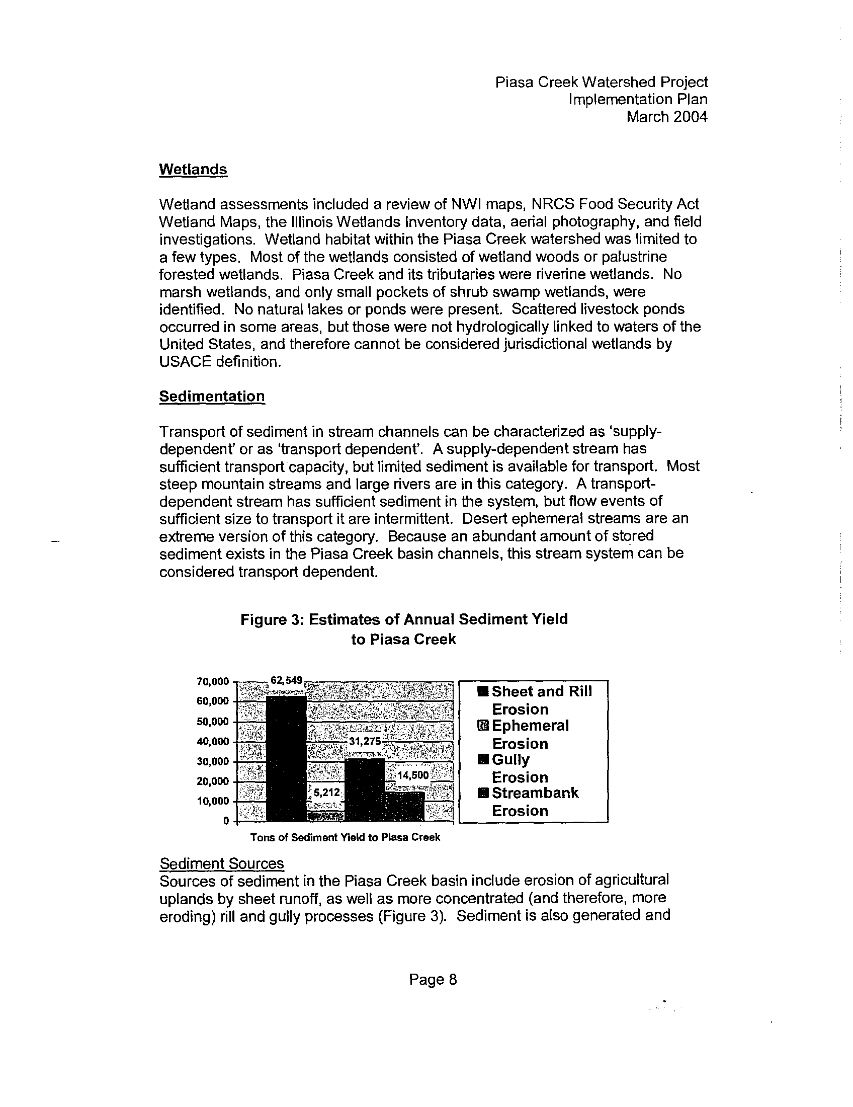
Sedimentation
Transport of sediment in stream channels can be characterized
as 'supply-
dependent' or as 'transport dependent' . A supply-dependent stream has
sufficient transport capacity, but limited sediment is available for transport
. Most
steep mountain streams and large rivers are in this category . A transport-
dependent stream has sufficient sediment in the system,
but flow events of
sufficient size to transport it are intermittent . Desert ephemeral streams are an
extreme version of this category.
Because an abundant amount of stored
sediment exists in the Piasa Creek basin channels, this stream system can be
considered transport dependent .
Figure 3 : Estimates of Annual Sediment Yield
to Piasa Creek
70,000
60,000
50,000
40,000
30,000
20,000
10,000
0
Tons of Sediment Yield to Plasa Creek
Sediment Sources
Sources of sediment in the Piasa Creek basin include erosion
of agricultural
uplands by sheet runoff, as well as more concentrated
(and therefore, more
eroding) rill and gully processes (Figure 3)
. Sediment is also generated and
Page 8
Piasa Creek Watershed Project
Implementation Plan
March 2004
•
Sheet and Rill
Erosion
® Ephemeral
Erosion
•
Gully
Erosion
•
Streambank
Erosion
Piasa Creek Watershed Project
Implementation Plan
March 2004
delivered to the stream system as a result of soil erosion from construction sites
and other areas of disturbed soil . Concentrated stormwater that is discharged
onto slopes in an uncontrolled manner, such as from culverts or ditches, can also
initiate gully erosion and contribute substantial volumes of sediment .
Sediment can also be generated from erosion of channel banks and beds . Flow
velocities and depths can increase substantially during periods of flooding as
seen in GIA Table 2 . As a result, greater shear stress on the bed and banks is
available to erode and transport sediment
. In general, the size and shape of
channels reflect the 1 .5 to 2-year return interval flood, referred to as 'channel-
forming events' . Because of the relative regularity of these flood events, they are
considered responsible for most of the work done in eroding and transporting
sediment within the basin .
The rate of runoff in the Piasa Creek Watershed has increased in recent years
due to an increase in less-permeable surfaces, such as roofs, roads, and
compacted bare soil . In addition, the time between rainfall onset and peak flow
has decreased as a result of increased channelization, such as drain tiles,
ditches and culverts . This change in basin hydrology has
resulted in a greater
frequency of channel-forming events, even though the average size and
frequency of precipitation storm events probably has not changed . Because
much of this hydrologic change has been recent relative to rates of stream-
channel formation, the impacted stream channels are still adjusting (i.e
.,
eroding)
to accommodate the larger and more frequent storm flows
.
In the Piasa Creek Watershed, the beds of many of the upper
and mid-channel
tributaries appear to be armored by bedrock or by gravel and cobbles derived
from bedrock . As
a result, incision in these channels is uncommon . It is not
clear if these channel beds were once alleviated (deposited
by flooding) and the
channel bed sediment has since been eroded, or if the channels were primarily
always founded on bedrock . It seems, at least for Mill
Creek and Rocky Fork that
the latter is most likely . In any event, because of the more
resistant channel
beds, channel erosion is concentrated primarily along
the banks
.
Mill Creek is relatively stable with respect to channel
bed and bank erosion, and
appears to be in relative equilibrium with respect to sediment
and flow events.
Where bank erosion does occur, it is generally limited to the outside of bends,
which is a natural process
.
In contrast, significant bank erosion is occurring all along Rocky Fork
. While the
uppermost reaches appear relatively stable, significant
bank erosion is occurring
in the reaches upstream and downstream from the confluence of two channels
.
In these reaches, the creek bed is composed of bedrock and
the banks are
undercut, near vertical and raw, with numerous trees having
toppled into the
Page 9
Piasa Creek Watershed Project
Implementation Plan
March 2004
channel . Further downstream, Rocky Fork flows through what was once the
Warren Levis Lake . This lake, which measured about 1,800 feet long and 400
feet wide, has filled with sediment to a depth of at least fifteen feet. A dam at the
west end of the lake was breached, allowing the lake to drain and Rocky Fork to
incise through the lake-deposited sediment
.
Banks along this reach were
composed of steep, bare sediment that was sloughing into the creek . In the
lower reaches of Rocky Fork, abundant sediment has been stored in lateral bars .
Bank erosion has occurred as a result of flows deflected by these bars into the
opposite banks
. In addition, channel aggradation has led
to increased bank
erosion .
Similar to the lower reach of Rocky Fork, abundant sediment deposition in the
low-gradient, lower reach of Piasa Creek has aggraded the channel and created
lateral side bars that shift channel flow into the opposite banks . The middle
reaches appear to be a zone of sediment transport and temporary storage, with
abundant in-channel sediment but only scattered areas of bank erosion .
Substantial aggradation can occur in reaches upstream of undersized stream
cross-sections that impede flow, while bed scour and formation of pools
commonly occurs where
flow is
constrained under bridges . Channel erosion
appears to dominate in the uppermost reaches of Piasa Creek .
Although the other tributary channels were not investigated to the same extent as
Piasa Creek, Mill Creek and Rocky Fork, based on similar land
use and
topography, channel conditions in East Newbern, East and West Little Piasa, and
West Piasa Creeks as identified in GIA Figure 1
are probably similar to those in
Upper Piasa Creek . Conditions in South Branch Creek may be closer to
conditions in Rocky Fork Creek (i .e., relatively greater amounts of channel
erosion) due to increased urban development resulting in increased storm runoff
and more frequent high flow events .
Sediment Transport
Erosion and transport of sediment in the Piasa Creek basin occurs primarily
during storm events . During the summer field season,
only fine suspended
sediment and fine sand bedload material was observed moving discontinuously .
As shown in GIA Table 2, estimated average discharges in the
tributaries and
upper reaches of Piasa Creek are very low .
These low discharges would
correspond to low depths and velocities . As a result, the average stream energy
to do 'work' (erode and transport) is also very low in these
reaches during
average flows
. However, as the estimated hydraulic data shows in GIA Table 2
for a flood event, flow depths and velocities are relatively high, resulting in a
greater amount of stream energy to do 'work' .
The type of sediment in the Piasa Creek system is generally
the easiest on which
to initiate movement because it is predominantly composed
of silt and sand. As
Page 10
a result, limited amounts of gravel and cobbles are available to provide a surface-
armoring layer, and particle cohesion is relatively low compared to clay-
dominated sediments . Although sediment data was not collected in Piasa Creek,
visual observations during the field studies indicated the mean sediment size at
most of the measured cross-sections probably ranges from fine to medium sand
(0 .1 to 2 millimeters in diameter) . These particle sizes are entrained at velocities
of 0 .6 to 1 feet per second (fps) . With estimated flood-event velocities in Piasa
Creek and its tributaries of 3 to 7 fps as found in GIA Table 2, substantial
sediment erosion and transport occurs during floods .
4. Sediment Reduction Project Plan
The sediment reduction project plan incorporates the findings of the GIA and
separates the projects into two major categories-Upland Treatment (rural and
urban) and Riparian Treatment .
The most effective measures to reduce the amount of sediment
are those that
reduce eroded sediment at the source before the sediment is transported off site
and into creeks and rivers . Examples of this type of measure include vegetative
cover such as reforestation ; storm water management controls ; best
management practices for agricultural, construction and urban sites; and land-
use changes that will result in a net reduction of erosion
potential. Reducing the
origin of in-channel sediment sources includes the use of channel grade controls
to slow or eliminate head-cutting and measures to stabilize
channel banks . The
types and numbers of sediment reduction projects proposed for the Upland and
Riparian treatment are presented in this section along
with the current estimate
of sediment reduction expected from these programs .
Upland Treatments
Due to increased runoff from agricultural and urban land
uses, and improved
subsurface drainage throughout much of the watershed,
Piasa Creek and its
tributaries are severely overtaxed during periods of excessive rainfall . Increased
drainage and fast runoff during these periods create problems
for both
agricultural and urban residents
. The primary tool is a sediment basin . There
are a number of different designs of the basic sediment basin
that can be
introduced in different settings based need and site
assessment. In some
instances, additional Best Management Practices (BMPs) such as grass
waterways, terraces and others may be used in conjunction
with the basins to
make them more efficient.
Piasa Creek Watershed Project
Implementation Plan
March 2004
Page 11
Piasa Creek Watershed Project
Implementation Plan
March 2004
Rural Sediment Basins
The mechanical practices of sediment basins will be designed to control gully
erosion, reduce sediment, and improve water quality . The sediment basins will
preserve the capacity of ditches, waterways, streams, and Piasa Creek . The
trapped sediment will reduce pollution by providing a place of deposition for soil
particles .
The improved water quality will be based on a 24-hour dewatering time on
cropland fields . This extended retention time will improve deposition time for
sediment load . The majority of these structures are farm through basins that
reduce the loss of production acres while still controlling erosion . The design
criteria of a 24-hour dewatering time will maximize water retention without
damage to growing crops .
Retention Basins
Another mechanical practice to improve water quality and retention of runoff is
the use of upland retention basins . These structures will hold water on a year
around basis. Their appearance is similar to a pond or lake,
however they have
a much greater temporary storage capacity during storm events . The retention
basins have the added capability of providing water for livestock, irrigation,
recreation and aesthetics . Upland retention basins will
be designed to reduce
the outflow to the standard of 0 .15 cfs per acre of drainage . This reduced rate of
release will control peak flow to the downstream drainage system and increase
trapping efficiency 50%-90% . The 0 .15 cfs is recommended by IDOT-DWR for
stormwater reduction and water quality improvement .
The performance of the practice will be calculated on the amount of drainage
acres of control . The control will be based on a 25-year storm event with stage
height above normal pool to control the outflow of 0
.15CFS/ac of drainage .
Participation would be limited to structures draining a minimum of 25 acres .
Urban Water Detention/Retention
Detention/retention facilities will be constructed in the urban portion of the
watershed, the Rocky Fork sub-basin, where feasible due to their increased
effectiveness and positive public acceptance
. Based on an analysis of each site,
some structures may retain water year around while others will only detain water
during storm events . These structures may also have an
associated wetland
area above the main structure . The constructed wetland will absorb stormwater
and pollutants, trap sediment and extend the life of the structure .
Removing pollutants will be achieved by gravitational settling, algal settling,
wetland plant uptake and bacterial decomposition
. The degree of pollutant
removal is a function of pool size in relation to the watershed area . Reliable
Page 12
removal can be achieved if the permanent pool is sized to store between 0 .5 and
1 .0 inch of runoff per contribution watershed area .
Reported sediment removal typically ranges from 50-90% . Urban water
detention/retention basins are not only reliable methods of pollutant removal but
also are widely adapted to most developments and have a longevity of 20 years
or longer .
An additional cause of water quality degradation is excessive streambank
erosion . Studies confirm the effectiveness of these extended detention ponds
not only for water quality improvement but also for "peak discharge control" and
"streambank erosion control ."
Design of detention facilities in the Rocky Fork Sub-Basin will follow the best
design procedures available to improve effectiveness, protect public safety,
increase wetland area, enhance wildlife habitat and consider aesthetic value of
proposed sites before and after construction .
The urban water detention structures will be based upon site suitability and will
focus on fewer but larger structures in the urban areas . Permanent
sedimentation basins will require periodic maintenance, and removal and
disposal of accumulated sediment . Maintenance will be the responsibility of the
landowner.
Riparian Treatment
Riparian Corridor Protection and Restoration
The riparian corridor is the zone of vegetation in, along, and adjacent to a creek,
stream, or river
. The riparian corridor varies in width, but if left unaltered would
include the out-of- bank-flow areas adjacent to streams . Forested areas of the
corridor contain deeply rooted tree species and shrubs that help bind the soil in
the creek banks . This reduces the rate of bank erosion and sediment delivery
into the stream
. Sediment from overland flow or from out-of-bank flow is trapped
by vegetation at the top of bank and adjacent to the channel . Reduction in the
size, or elimination of, the riparian corridor results in an increase in the amount of
sediment eroded and the rate of transport
. In addition to trapping sediment,
trees, shrubs, and grasses in a riparian zone help remove nutrients, pesticides,
pathogens, and other potential pollutants before they enter a stream or creek . A
riparian corridor will help retain runoff and improve infiltration
. A riparian zone
can provide habitat, cover, and travel corridors for many species of wildlife
.
Streambank Stabilization
Unstable streambanks along Piasa Creek contribute a significant amount of
sediment to the channel
. Because of the variability in channel flow and velocity,
Piasa Creek Watershed Project
Implementation Plan
March 2004
Page 13
Piasa Creek Watershed Project
Implementation Plan
March 2004
the banks are prone to caving and undercutting during periods of high water or
storm events . Agricultural producers in the watershed often exacerbate this
problem by farming to the very edge of the watercourse . This increases the
potential for the channel to cut into fields, damaging crops and property, and
adding sediment load to the stream flow
.
The primary objective of riparian corridor treatment is to improve and maintain
the quality of streams within the Piasa Creek Watershed and ultimately the
condition of the Mississippi River
. Objectives for obtaining this goal include the
implementation of streambank stabilization practices such as stream buffers,
pool and riffle technology, incorporating peak stone protection, and debris
removal .
In the past, bank protection usually meant hardening the bank with materials
such as rock, broken concrete, old cars and other discarded materials . Rock
usually was loose dumped, but was occasionally placed as an engineered, riprap
revetment
.
With changes in the Clean Water Act in recent years, more attention and effort
has been directed at less 'hard' measures, and more 'soft' measures . These soft
measures are typically referred to as 'biotechnical stabilization' or'bio-
stabilization' measures because they incorporate some of the engineered hard
methods in combination with the use of live plant and wood material . Although
the use of biotechnical measures can enhance the riparian habitat compared with
a rock revetment, there are some instances where the hydraulic forces and/or the
channel geomorphic conditions preclude the effective use of these softer
measures . Deep-rooted riparian vegetation helps to bind the soil along
streambanks, which helps prevent sloughing off of the banks
. Because the bio-
technical measures rely to varying degrees on the root reinforcement and
channel roughening characteristics of live plant material, a lag period of several
months to several years often occurs until the plants are well developed .
Biotechnical bank stabilization measures are most vulnerable to damage from
flooding and erosion during this lag time, and may require partial repair or
replacement.
The following is a list of various bank protection measures, in approximate order
from 'softest to hardest' . Subsequent items can be added to those listed
previously for combinations with increased bank stability .
•
Bank regrading and revegetation - bank is graded to a typical 2 Horizontal
to 1
•
Vertical (2H
: 1V) slope or flatter, and planted with native grasses and
shrubs
. Water velocities of greater than six feet per second can adversely
affect some vegetation.
Page 14
•
Erosion control blankets- natural or synthetic fiber blankets
maybe laid
over regraded bank and incorporated into revegetation .
•
Toe rock - appropriately sized rock is placed along the toe of the re-
graded bank where scour and erosion is greatest . Toe rock works well
with using vegetation to stabilize other portions of the bank
. Living or non-
living vegetated materials may also be used for toe protection . Reed or
willow rolls and bundles, or rolls constructed of coir (wood) fibers are also
useful . Cribbing of willow or other wood timber is another form of toe
protection .
•
Stone peaks - small piles of stone extending out a short distance from the
bank provide a hard point that can anchor softer bank protection .
•
Rock barbs - rock dikes built to normal high water elevation and extending
out from the bank at an angle oriented upstream . The barbs are intended
to deflect flow away from the bank .
•
Rock spurs - similar to barbs, but larger in that they are built as high as
the design flood level .
•
Full rock revetment- typical bank riprap revetment extending from the toe
up to the bank top or just above design flood elevation . Vegetation is
commonly planted between the rocks
.
Prior to construction of channel bank stabilization measures in Piasa Creek or its
tributaries, a study is conducted of the reach, including drainage area for a given
location, estimated peak storm flows and velocities and
other hydrologic and
hydraulic characteristics . Soil characteristics related
to bank stability (grain size,
permeability, areas of seepage) and types of vegetation the soil can support, and
potential upstream sediment sources that could compromise the stability of an
improvement at a specific location should also be investigated .
Section 404 of the Clean Water Act requires that the U .S
. Army Corps of
Engineers issue a permit for the dredging or filling of material into wetlands and
waters of the United States . Section 10 of the Rivers and Harbor Act has similar
requirements
. Rules formulated for implementing Section 404 will limit the
amount of 'hard' material that may be placed in a water of the U.S
. for
stabilization purposes
.
Rock Riffles
In many areas of Illinois, increased flooding has prompted
landowners to
channelize i .e .,
straighten streams so that floodwaters leave their property more
Piasa Creek Watershed Project
Implementation Plan
March 2004
Page 15
Piasa Creek Watershed Project
Implementation Plan
March 2004
quickly . Unfortunately, channelization increases stream power by increasing the
slope of the channelized section
.
Increased power enables the stream to do
more work to erode its channel and banks, thus increasing the potential for
damage to adjacent properties .
Artificial riffles are made of stone to distribute the drop in streambed elevation
over a longer distance. The technique drowns out the points
of maximum
channel incision and allows the riffles to adjust to future streambed changes .
The riffles are spaced so that local scour creates a pool downstream of each
riffle . Essential to this technique is that sediment is not trapped in pools and bed
material is allowed to move through each pool and riffle . The erosive energy of
floods is dissipated in the deeper pools, thereby reducing bank erosion and
lateral channel migration, and inhibiting the upstream movement of channel
incision. Therefore, the rock riffles not only reduce
bank erosion in channelized
reaches, but they inhibit excessive bank erosion upstream. The technique
provides stability to a stream reach while also protecting the entire watershed
.
Other Best Manaqement Practices
While sediment basins, water retention/detention basins and various streambank
stabilization methods are the tools with the highest level of erosion control, there
may be circumstances at a particular site where other options
may be the best fit
for that situation . In those instances, other Best Management Practices (BMPs)
may be considered . Best Management Practices are those construction
practices that will result in water quality improvements,
particularly sediment
reduction, in a watershed .
While many of the examples given are for use in urban areas, many are
applicable to non-urban areas as well, particularly those
that apply to
construction sites
. Applicable BMPs include :
Protecting grassed buffers at the perimeter of the construction site to help
trap sediment
.
•
Use of sediment fences or staked straw bales to trap sediment before it
leaves a site .
In addition to Best Management Practices that apply to construction
sites and
urban areas, many BMPs apply to agricultural areas as well
. These include :
•
Filter strips of grass, legumes or other non-woody vegetation
that filters
runoff and significantly reduce the amount of sediment
and nutrients
entering a water body .
Page 16
Piasa Creek Watershed Project
Implementation Plan
March 2004
Grass waterways that are either natural or manmade channels to stabilize
small gullies and washouts .
Land Acquisition and Protection
Just as important as upland water detention sites, cropped wetlands, bottomland
fields and riparian areas subject to seasonal flooding should be allowed to carry
out temporary detention functions . From a watershed or community perspective,
these lowlands are potentially more valuable for flood control purposes than they
are for agricultural production . Cropped wetlands and bottomland fields in the
floodplain of Piasa Creek should be targeted for acquisition and conservation
easements.
The introduction of agricultural practices and urbanization into the watershed has
resulted in the two largest causes of increased rates of erosion and sediment
transport within the watershed . As land cover and land uses have changed over
the years, the amount and velocity of storm water flow has increased with a
resultant increase in the rate of erosion and sediment transport, and a resultant
increase in the amount of sediment delivered downstream from its source .
Certain land use practices can be effective in reducing the rate and amount of
erosion, the rate and amount of storm water runoff, and the rate and amount of
sediment delivery .
Agricultural areas loose an average of eight tons of soil per acre per year, and
higher on highly erodible soils and slopes . Forest areas lose an average of one
ton or less of soil per acre per year . Reforestation of agricultural areas would
potentially yield an annual reduction of seven or more tons of sediment per acre .
The majority of Piasa Creek Watershed is in agricultural production, making it the
single largest contributor of soil loss and sedimentation in the watershed . Taking
agricultural areas that are of marginal value out of production and allowing them
to revert to forest will result in a significant annual reduction of sediment yields in
the Piasa Creek .
Development of a greenway to protect the riparian corridor is a positive land use
policy that will help to protect the channel banks, and trap and reduce sediment.
This will have the added benefit of providing protected open space
. Greenways
can provide recreation opportunities for people living within the Piasa Creek
watershed and nearby communities . Greenways can enhance adjacent property
values. Greenways may be developed by property acquisition or by use of
conservation easements
. Greenways require little maintenance .
Greenway development, buffer zones along stream corridors, open space
preservation along stream corridors and in highly erodible areas, and
establishment of conservation easements for forested areas and riparian zones
Page 17
I
Page 18
Piasa Creek Watershed Project
Implementation Plan
March 2004
may be used to help fulfill the National Pollutant Discharge Elimination System
(NPDES) Phase II requirements of the Clean Water Act for small municipalities .
This may be of additional benefit to urbanizing areas along Rocky Fork
.
Wetland Restoration
One of the primary functions of wetlands is to trap sediment . In the case of Piasa
Creek, this occurs for sediment transported by overland
flow that passes through
a wetland prior to entering the channel of Piasa Creek or its tributaries . It can
also occur from sediment transported by out-of-bank flows (flooding) from the
creek or its tributaries . For most of the existing wetlands adjacent to Piasa Creek
and its tributaries, most sediment is captured during periods of flooding
.
Restoring prior-converted wetlands and farmed wetlands to wetland conditions
will have a positive affect on sediment transport in
Piasa Creek . Prior-converted
wetlands are those areas that have been converted or drained
by some method
for agricultural purposes . Farmed wetlands are those wetlands that have not
been drained, but are dry enough to farm periodically .
Restoring wetland areas adjacent to Piasa Creek and the
lower reaches of its
tributaries will be more effective in reducing sediment than in restoring wetlands
in the upper reaches of the watershed . Sediment loads in the stream are greater
in the lower reaches . Longer duration flooding in the lower
reaches allows
interaction between sediment laden flood flows and wetlands
to occur for a
greater period of time. Letting prior-converted wetlands revert to wetlands in
upland areas will intercept sediment that eroded from
adjacent agriculture fields .
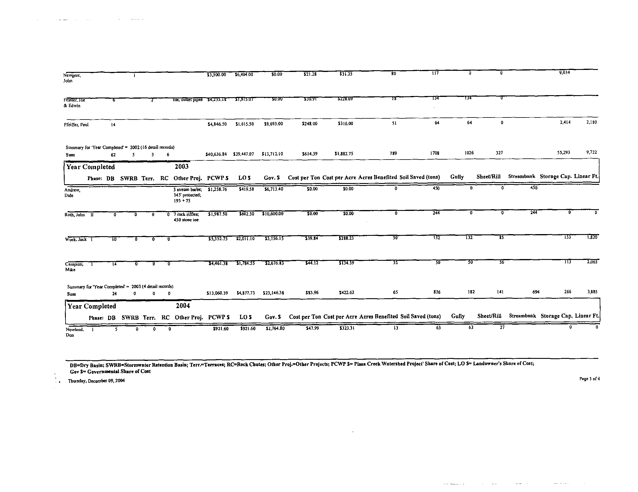
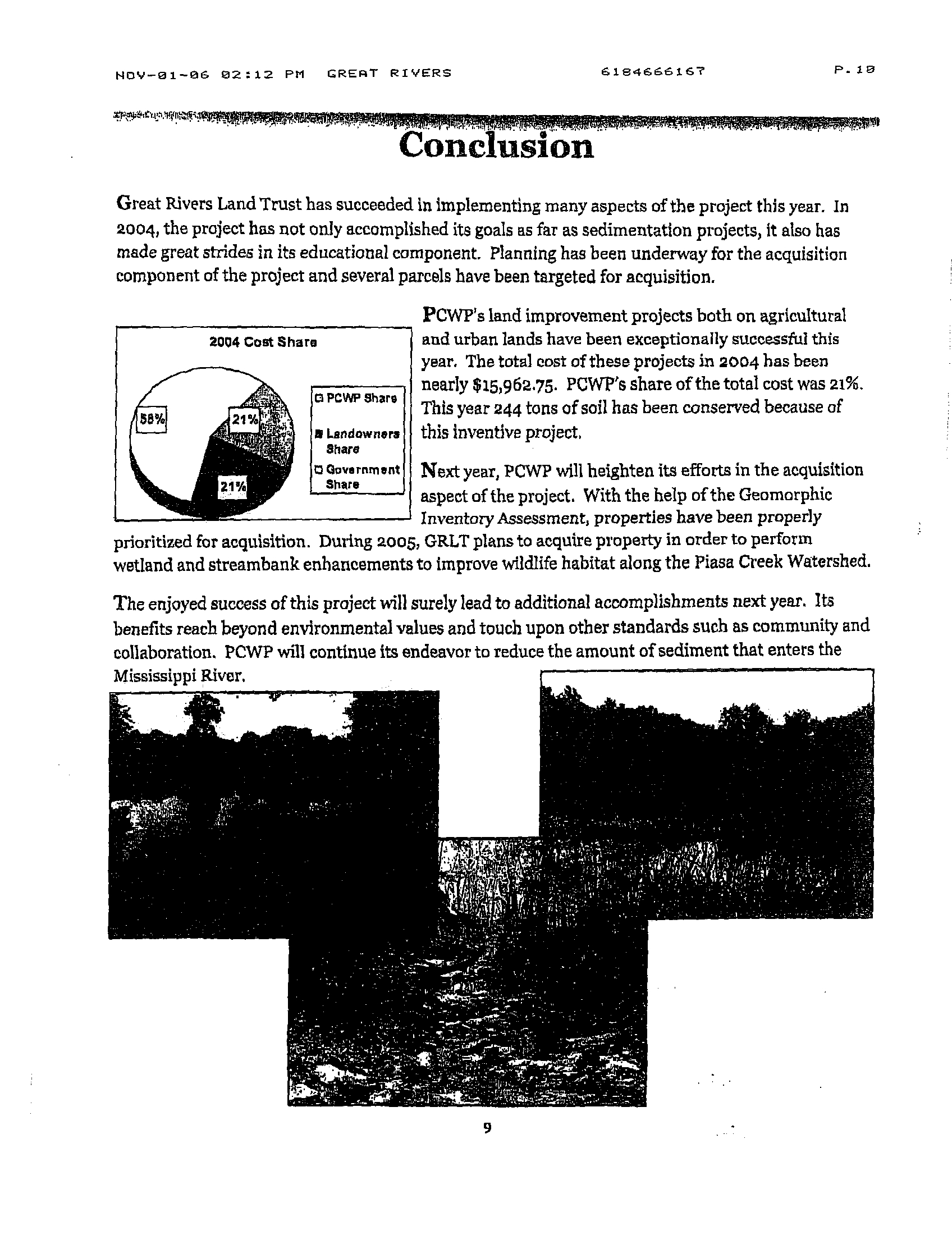
SEDIMENT REDUCTION PROJECT SUMMARY
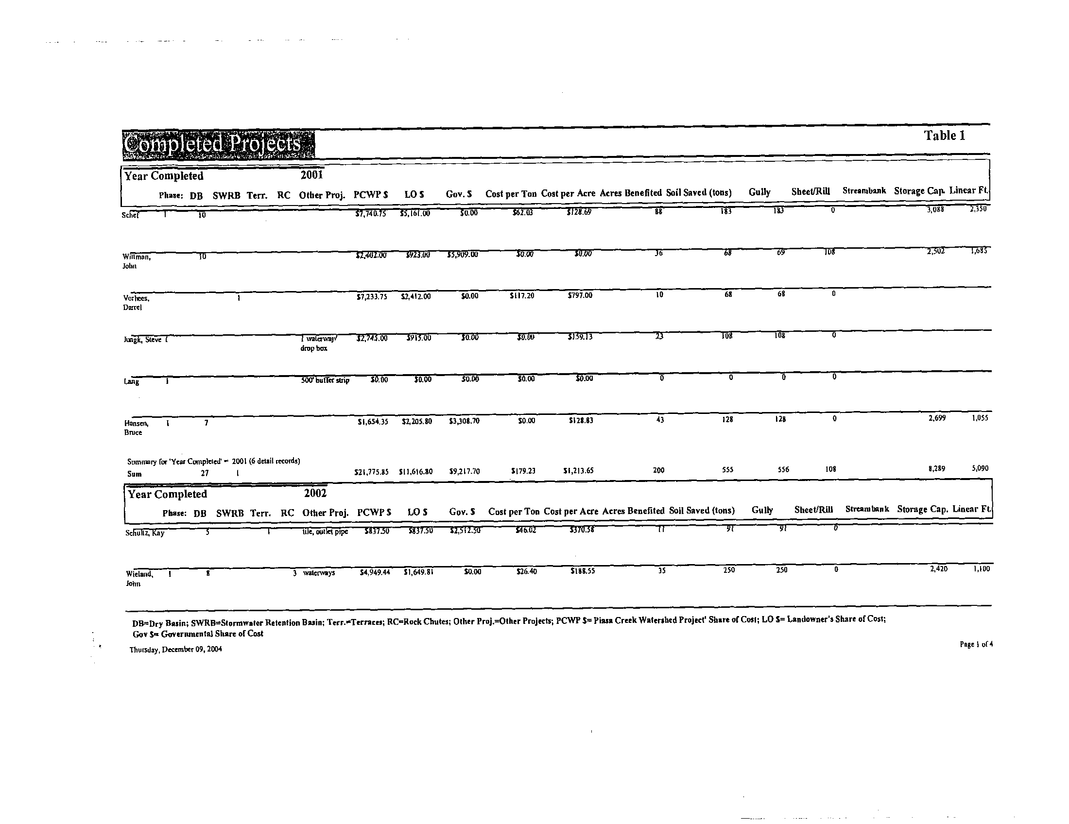
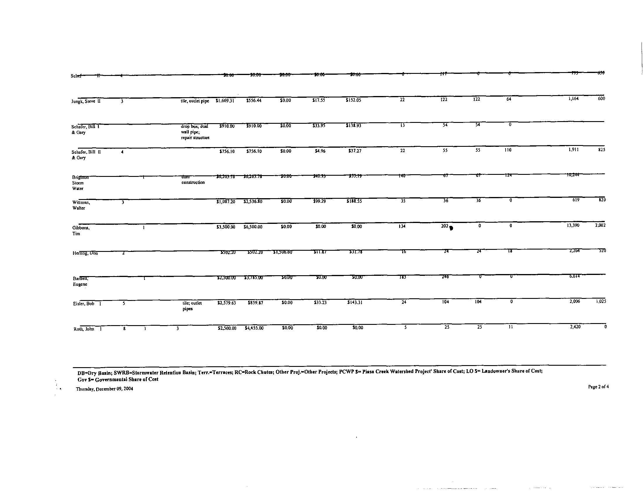
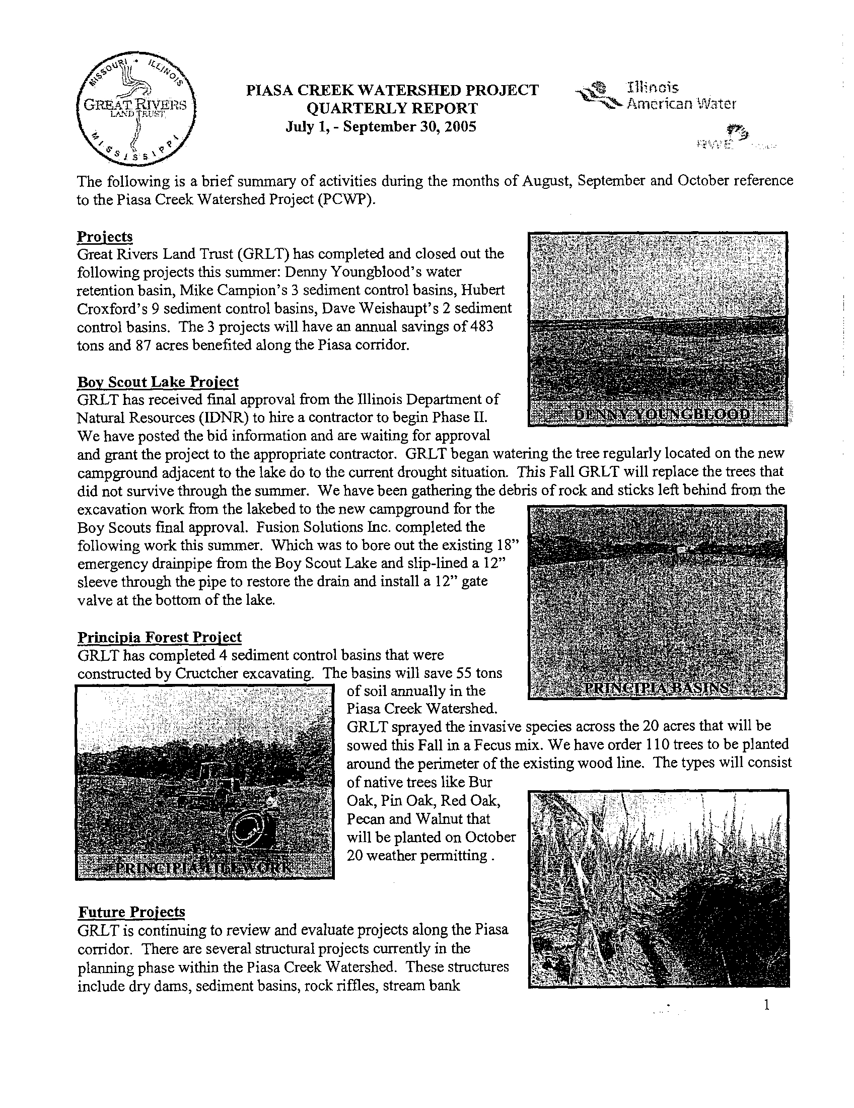
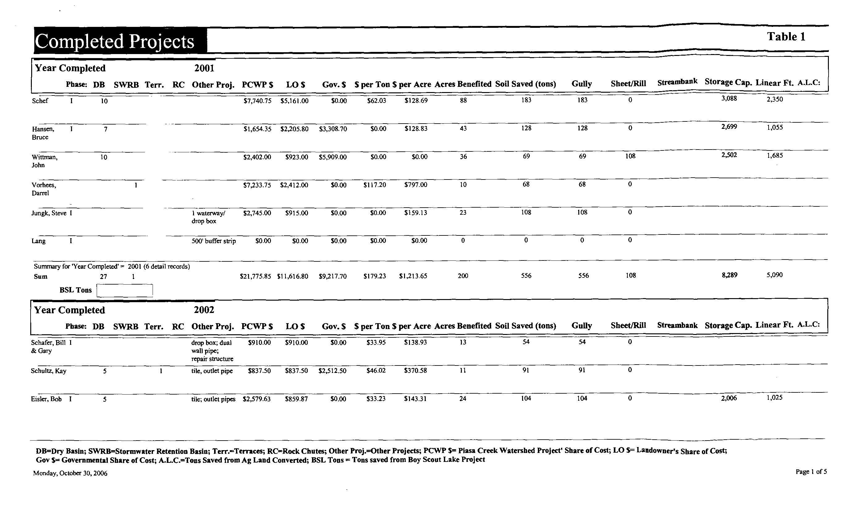
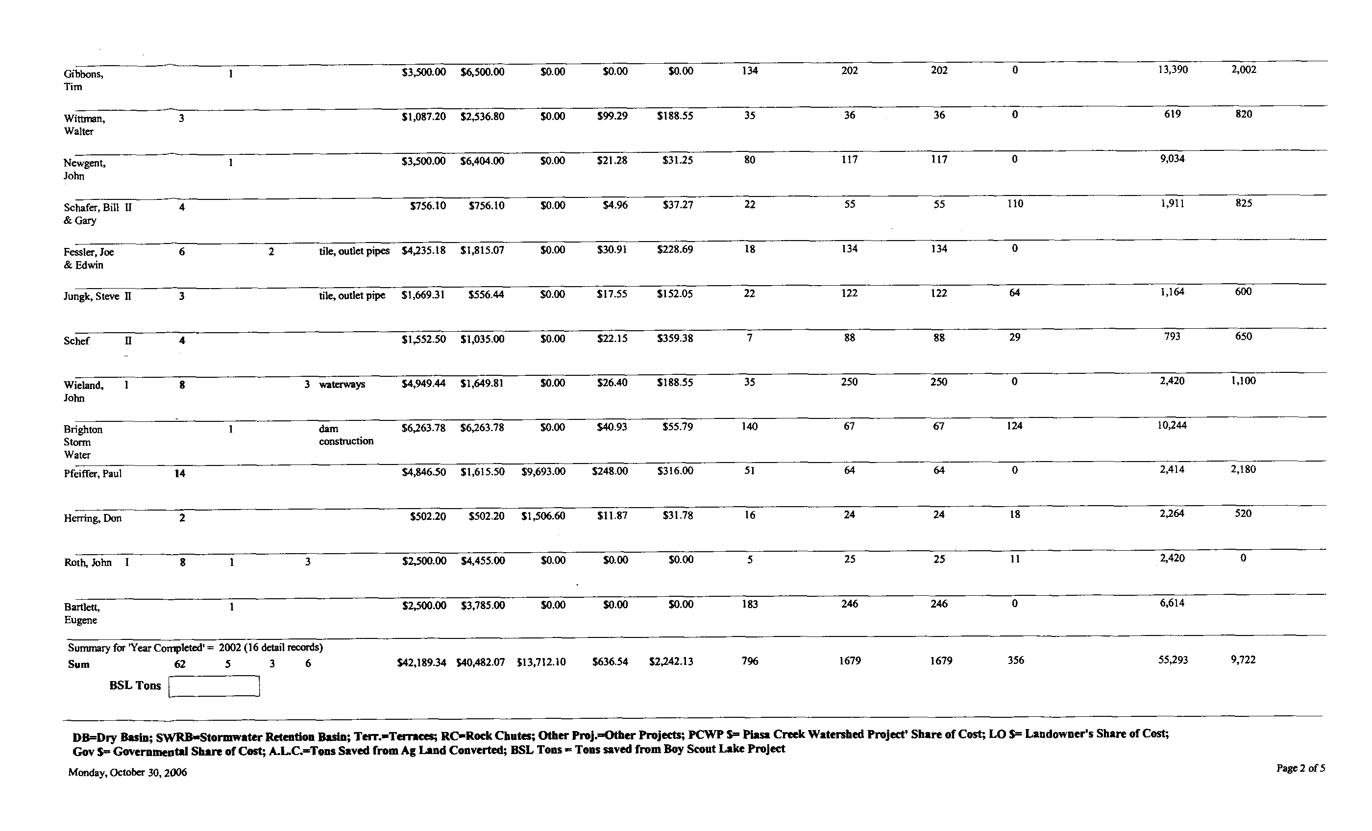
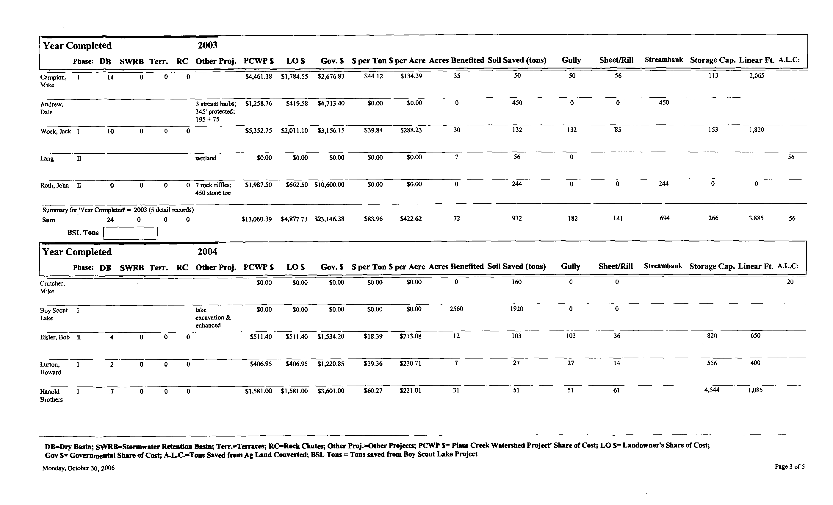
Since the Piasa Creek Watershed Project began in 2001 numerous projects have
been completed including a total of 113 sediment basins,
6 stormwater detention
basins, 3 field terraces, a 500 foot buffer strip, 3 grass waterways, 1 grade
control structure, 2 streambank stabilization projects
that incorporated 3 stream
barbs, 7 rock riffles, and 450 of stone toe protection
(Figure 4) . Each project is
documented and has calculations of numerous statistics including cost and tons
of soil saved . As of January 1, 2004, a total of 3,716 tons of soil have been
controlled (Table 1) .
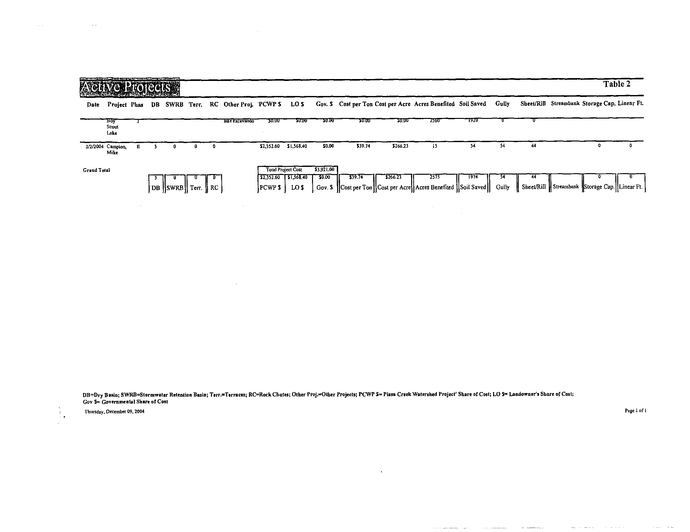
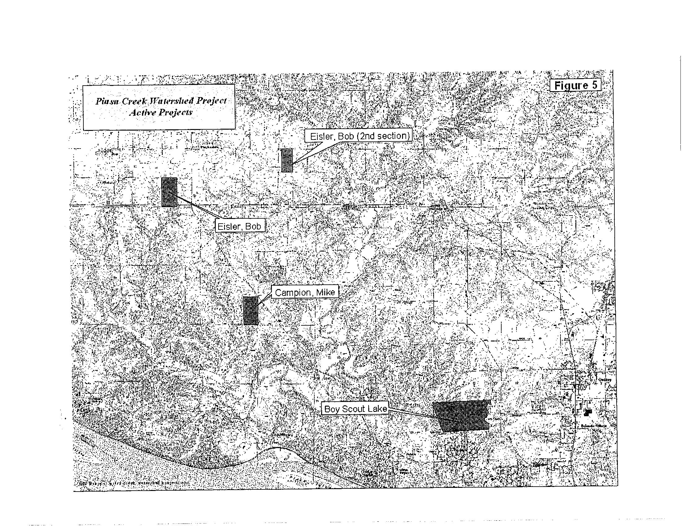
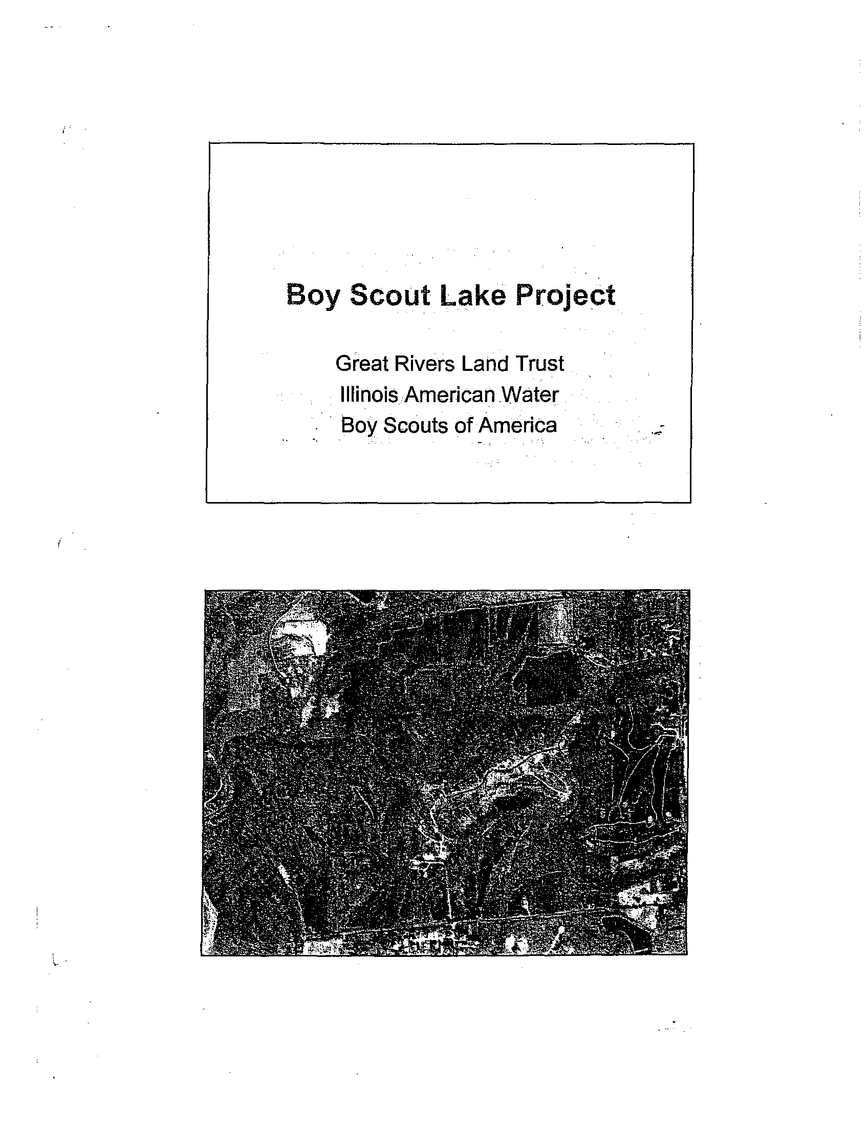
Projects in the active phase include the restoration of the
Camp Warren Levis
Boy Scout Lake in the Rocky Fork Sub-basin
. The Warren Levis Lake
restoration is the largest individual project to date . It involves the excavation of
15 acres of a silted-in lakebed and the establishment of a
10 acre enhanced
wetland above the restored portion of the lake . Completion is anticipated for
April of 2004 . Other projects in the active phase include
an additional 15 smaller
sediment basins in the agricultural sector (Table 2, Figure 5) .
Piasa Creek Watershed Project
Implementation Plan
March 2004
In the area of land protection, GRLT has acquired 169 acres in the Piasa Creek
Watershed, holds conservation easements on 253 acres, has pledges of
conservation easements on an additional 20 acres, and
is in negotiations with
landowners for the acquisition of an additional 151 acres
. Already 422 acres of
the Piasa Watershed have been protected and it is anticipated that over 600
acres will be protected by the completion of the overall
project
.
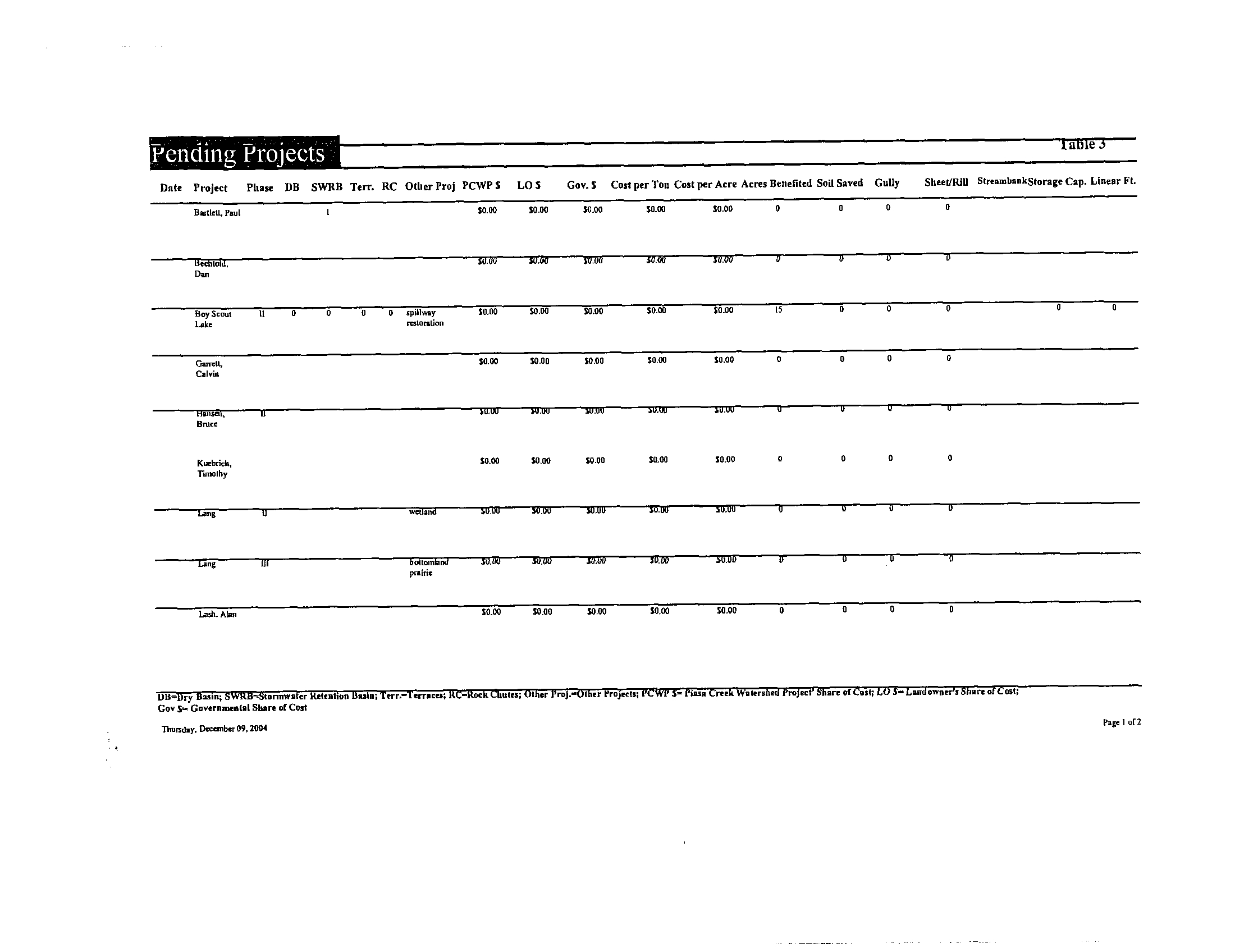
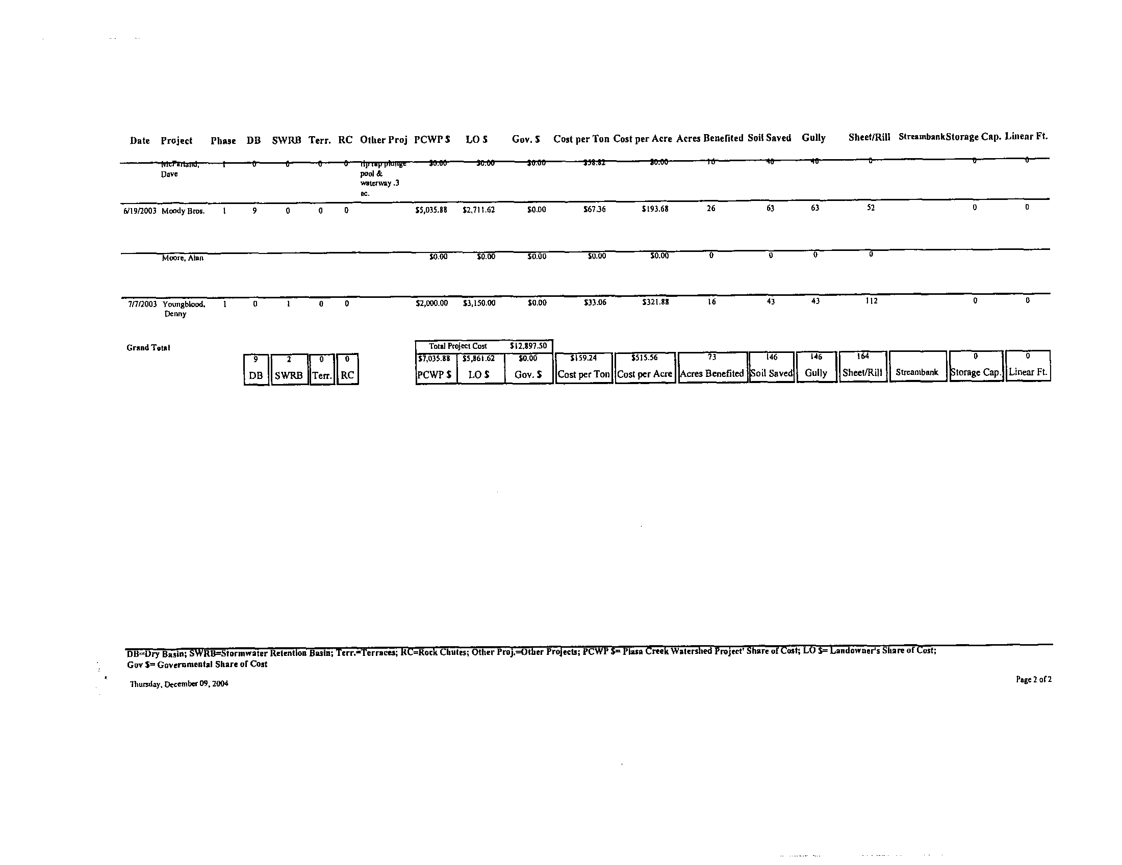
Numerous pending projects are at various stages in the planning process.
Although a number of sediment basins are on the pending projects list (Table 3)
many others are anticipated following the completion
of the Warren Levis Lake
Project . The Piasa Creek Watershed Project is expected to receive more
requests for projects than are possible to complete in the years that remain in the
project timeline. It is anticipated that projects that provide the highest level of
erosion control at the lowest cost will receive highest priority . High quality
projects will still be considered in the agricultural community . A small number of
larger scale sediment control projects will be considered
in the four sub-basins
(West Little Piasa, West Piasa, Upper Piasa, and East Little
Piasa) with the
highest erosion control potential from agricultural
practices and in the Rocky Fork
Sub-basin, the only urban sector (Figure 6)
.
It is estimated that an additional 250 sediment basins will
be constructed in the
watershed, primarily in the agricultural sector
. An additional 5 larger scale water
retention/detention basins will be constructed, one in each of the three northern
sub-basins and two in the Rocky Fork sub-basin
. It is also anticipated that an
average of two large-scale streambank stabilization projects will be completed in
each of the next five years . Additional land and easement
acquisition will be
based on availability of priority properties, price,
and supplementary grants and
donations form outside sources . Other best management practices will be
implemented on a case-by-case basis
.
4.
Piasa Creek Watershed Project Sediment Reduction Quantification
The method of quantifying sediment reductions into the Piasa Creek is the
Sediment Input Reduction Analysis Method (SIRAM) .
SIRAM measures erosion
and sediment trapped through the construction of sediment
basins, stream
buffers, retention and detention basins, and other best management practices
.
SIRAM is a summation of the sediment calculations from various
erosion control
practices
. All calculations will be based on United States Department of
Agriculture (USDA) standards, including LISLE (Universal
Soil Loss Equation)
and RUSLE (Revised Universal Soil Loss Equation) .
Page 19
Piasa Creek Watershed Project
Implementation Plan
March 2004
Different types of erosion have different methods of measurement
. The four
major forms of erosion include sheet and rill, ephemeral, gully and streambank .
•
Sheet and Rill Erosion Rate for Cropped A / B slopes x Acres x SDR 1
•
Sheet and Rill Erosion Rate for Cropped C / D slopes x Acres x SDR 2
•
Sheet and Rill Erosion Rate for Pasture x Acres x SDR 3
•
Sheet and Rill Erosion Rate for Timber x Acres x SDR 4
•
Sheet and Rill Erosion Rate for Urban x Acres x SDR 5
•
Ephemeral Rate x Acres of affected cropland x SDR 6
•
Gully Erosion Rate x Feet of eroding gullies x SDR 7
•
Streambank Erosion Rate X Feet of eroding streambank X SDR 8
Each type of erosion produces sediment, but each also produces differing
amounts
. The amount of sediment produced by the different forms of erosion is
the Sediment Delivery Rate (SDR) . Sheet and Rill erosion has the most variable
SDR's due to the sheet flow
. Ephemeral, gully, and streambank erosion are
considered different forms of channel flow, with generally greater SDR's but less
variability
. The appropriate SDR is multiplied times the gross erosion amounts
for that type of erosion, within a given land use, to obtain sediment "delivered to
the field edge" and ready for flow into the stream system. The total of these
products give the gross erosion in the watershed
. The sediment delivery rate will
then be used in the sediment trapping calculation of any of the erosion control
practices. For example, if it was determined that the best practice to control a
gully erosion problem on an agricultural site was to construct a sediment basin,
an analysis of the site would be conducted . Factors considered would include
the total number of acres drained, soil type, slope, land use, etc, to determine the
gully erosion rate, multiplied by the total feet of eroding gully to give the sediment
delivery rate for that site. If the SDR for this particular project was 100 tons and
a sediment basin was constructed on the site with a trapping efficiency of 90%,
the soil savings would be 90 tons . Soil erosion reductions will be further verified
by periodic physical measurements at completed project sites
.
Documentation of all structures and activities are compiled on an Access
database that keeps a record of all completed, active, pending and future
projects
. (Table 1,2,3 and Figure 4,5) The program will maintain a composite of
the total tons of soil saved from erosion, cost per ton, cost per acre, acres
effected, ownership, cost share dollars, cost share sources and digital photos of
Page 20
Piasa Creek Watershed Project
Implementation Plan
March 2004
each project site . All of the data will be linked to a watershed map to further
clarify the location of each project. GRLT will be responsible for the maintenance
of all records and documentation on the Piasa Creek Watershed Project and will
submit quarterly reports to IAW and the IEPA . The first and third quarterly report
will include the most recent data on the tons of soil saved based on completed
projects . Each end of year report will include the tons of soil saved to date and
projections on the tons of soil savings based on active, pending and future
projects . A time-line illustration will be included with the annual report .
A basis for long-term monitoring was established by identifying 30 monitoring
sites, or 'cross-sections, throughout the watershed . An evaluation of existing
channel conditions at each site included an assessment of the bank and bed
materials, and bank vegetation . Habitat adjacent to Piasa Creek and its
tributaries was identified, including areas of riparian forest, wetlands, and others .
Wetlands that were hydrologically linked to Piasa Creek and its tributaries were
identified based on analysis of existing data and visually verified in the field .
Soils with high erosion potential and hydric soils were identified within the
watershed using NRCS soil surveys and other published data . The information
compiled at the 30 cross-sections will be used not only during the course of this
10-year project, but well into the future . The cross-section data will provide
baseline data for initial work, supporting documentation, and grant development .
It will also serve as the foundation for future studies 15, 20 or even 30 years into
the future
. The methods of electronic documentation and the baseline
identification of monitoring site will also serve as an example and guide to other
watershed implementation efforts in the state and in the country
.
The Piasa Creek watershed was divided into ten subbasins . These subbasins
range in area from approximately 3,220 acres to 16,050 acres as shown in GIA
Table 1 . Thirty channel cross-sections of the existing channel were measured in
the field at key points within the watershed, and at least one cross-section in
each subbasin . Cross-sections were taken at points immediately above and
below the location where a tributary joined the main channel, and where distinct
changes in basin and sub-basin characteristics were observed . Channel and
bed conditions, including hydraulic roughness, were identified at each cross-
section . Channel slope instabilities, where they occurred, were also noted at
each cross-section .
Vegetation was characterized at each cross-section, both in channel and
adjacent to the channel . Identified habitats were correlated with published
mapped data . The depth of rooting was measured on each bank, where it could
be determined
. Each cross-section was photo-documented . Elevations at each
cross-section were determined using USGS Quadrangle maps of the watershed,
and other sources of published topographic data
. The channel width-to-depth
ratio was calculated at each cross section, and used for further analysis of
Page 21
channel morphology
. The channel slope was determined from survey data
collected in the field . Evidence of channel down-cutting, when present, was
ascertained at each cross-section . As no historic stream-gage data was
available, stream power was estimated using the channel slope, cross-section
area and drainage area at key locations .
Photographic documentation of each
cross-section and other field data is found in the Geomorphic Inventory
Assessment of the Piasa Creek Watershed .
The 30 cross-sections identified in the Geomorphic Inventory Assessment report
will be monitored on periodic basis . A frequency of no more than every two
years and no greater than every five years should be a sufficient
interval . This
will give a dynamic picture of how the channels are changing over time . The
sections have been monumented, and located with a GPS system .
This will
make locating the sections relatively simple for future monitoring purposes .
The educational component (PC-WET program) will also conduct monitoring
along the Piasa Creek
. The monitoring will include physical, chemical, and
biological parameters at twelve permanent site locations . Most of the chemical
analyses will be done using instrumentation such as Computer
Based Laboratory
Calculator (CBLs) and Hach DRL instrumentation . The chemical parameters
include : dissolved oxygen, nitrite/nitrates, five day
BOD, phosphorous, pH, and
hardness
. All test procedures will meet EPA standards for data reporting . The
physical parameters will include
: flow rates, depths, sedimentation, and
temperature . Field computers with interfacing probes will be used for the
physical parameters
. Biological parameters will include fecal coliforms and
macroinvertebrates as water quality indicators .
5. Stormwater Ordinance Development
Piasa Creek Watershed Project
Implementation Plan
March 2004
Urban runoff can be a significant source of sediment in a watershed, and is one
of the primary components of urban non-point source pollutants . Urbanization
will have the net affect of increasing the peak of a storm water hydrograph
compared to a pre-urban condition
. Urbanization will also result in the peak
being reached more rapidly than in a non-urban situation . A higher, quicker peak
means that a greater volume of storm water would enter a
creek in a much
shorter period of time with a greater velocity than would
normally be expected in
a non-urban situation . The end result is that the potential for erosion and
sediment transport increases .
Implementing storm water management guidelines will
help to level out the
hydrograph following a storm in an urban area . The use of detention basins will
limit or 'detain' water flowing from a development to pre-development levels .
Detention basins may be either wet detention or dry detention
. Detention basins
Page 22
have the added benefit of trapping sediment at the source, in addition to reducing
erosion potential downstream .
A storm water management, erosion control, and sediment-control ordinance for
urban areas can provide requirements for reducing sediment production at its
source and managing the rate and flow of storm water and sediment transport .
6.
Education and Public Awareness Programs
The most effective methods for deliverance of a knowledge-based program
involve public seminars, demonstrations, and extensive media promotions . This
methodology can be used to focus on the specific issues unique to the Piasa
Creek Watershed .
Brochures, Newsletters and Website
To encourage participation by area landowners, informational brochures have
been developed for distribution throughout the watershed . GRLT publishes its
own brochure about the Piasa Creek Watershed Project (PCWP) . This brochure
provides an overview of what a watershed is and basic facts regarding the Piasa
Creek Watershed . The publication continues by illustrating the various problems
associated by different types of erosion along with the tools GRLT uses to solve
those particular problems . The brochure is distributed at Soil & Water
Conservation Districts and USDA Service Centers, county courthouses, and
libraries in the PCWP three county region .
GRLT distributes a newsletter twice a year to approximately 2,500 residents of
the region . Updates on the Piasa Creek Watershed Project are included in each
issue .
The Piasa Creek Watershed Project is highlighted on the GRLT website, showing
maps and an assortment of projects and updates on the effort . The website is
www. greatriversl
andtrust. com
.
Tours
As various projects are completed, such as stream buffers, sediment basins, riffle
pools, etc.,
tours will be arranged for area landowners to further encourage their
participation by viewing successfully completed projects . On June 14, 2002,
GRLT together with the PC-WET program hosted a driving tour of the major
projects in the Piasa Creek Watershed Project
. The trip began at Lewis & Clark
Community College and drove along the sites of various projects that have been
implemented or are in the planning stages
. Along the way, PC-WET participants
performed water quality tests along certain areas of the creek . The tour proved
Piasa Creek Watershed Project
Implementation Plan
March 2004
Page 23
to be a hands-on approach to learning about how various tools can be utilized to
prevent sediment reduction in the Piasa Creek Watershed .
Press
Piasa Creek Watershed Project has been publicized by various press releases
since the project's beginning in 2000
. These press releases have been in
newspaper publications such as the St . Louis Post Dispatch, the Alton
Telegraph, and the Illinois Business Journal . The project has also been featured
in public radio announcements on WBGZ . Making the public more aware of this
important project has made public acceptance of PWCP a reality. The following
reflects in more detail some of the press releases during recent years
.
•
Illinois Business Journal (2001) -
"Piasa Creek Watershed Project to have
Benefits for All"
•
Alton Telegraph (2002)-"Decision May Help River, Water Plant'
•
St. Louis Post Dispatch (August 8, 2002) -"Organization Will Restore
Lake at Boy Scout Camp"
•
St. Louis Post Dispatch (September 5, 2002) -
"Boy Scout Board OK's
Plans to Develop Lake"
•
St
. Louis Post Dispatch (November, 2002) - "Piasa Watershed May Get
Federal Fund Boost"
•
Alton Telegraph (February 11, 2003)-"Council recommends Catholic
Charities Lease"
•
Alton Telegraph (February 11, 2003)- "After years of planning, road
project to begin"
•
Alton Telegraph (October 3, 2003) -
"Deal will preserve Scout camp in
Godfrey: Conservation group plans to restore 15 acres at Camp Warren
Levis"
•
St
. Louis Post-Dispatch (October 29, 2003)-"Joint project will restore use
of silted-up lake at Scouts' Camp Warren Levis near Godfrey"
•
Alton Telegraph (October 30, 2003) - "Open house Sunday at Camp
Warren Levis"
Page 24
Piasa Creek Watershed Project
Implementation Plan
March 2004
Awards
Piasa Creek Watershed Project was selected as a finalist for the 16th Annual
Governor's Pollution Prevention Awards hosted by the Illinois Waste
Management and Research Center (WMRC). The Governor's Pollution
Prevention Awards annually honor Illinois companies and organizations that are
making efforts to reduce their environmental impact and improve their economic
viability . The award ceremony was held on October 18, 2002 in Champaign,
Illinois
. GRLT's Alley Ringhausen and Amanda Langford attended the event as
well as Mark Johnson from IAW .
Piasa CreekWatershed EducationTeam Project
The Piasa Creek Watershed Education Team Project (PCWET) is an academic
environmental education project that allows middle school students to better
understand the importance of water quality to their community and fosters a
sense of stewardship for their watershed
.
Twenty public and parochial middle schools and two public high schools are
currently participating in the project . It utilizes the watershed as and outdoor
classroom for over one thousand students in the three southwestern Illinois
counties . Through a comprehensive watershed monitoring program, involving
the latest educational technology, the students collect baseline data for the
determination of long-term changes in the physical, chemical and biological
parameters of the watershed . The parameters include flow rates, sedimentation
loads, temperature, depth, pH, dissolved oxygen, phosphates, nitrates, hardness,
BOD, fecal coliform and macro invertebrate indices
.
Grants
Many sources of funding have contributed to the success of the Piasa Creek
Watershed Project. The fundamental funding source for the project comes from
IAW
. The water company will provide $4 million in funding for the 10-year
project. Supplemental funding from other sources can be found from the
following :
•
Illinois Department of Natural Resources, C2000 Program -
$15,000
•
Trees Forever, Illinois Buffer Initiative
- $2, 000
•
Illinois Department of Transportation - $5,400
•
Illinois Clean Energy Community Foundation -
$200,000
•
Service Learning Grant - $4,000
•
Illinois Department of Agriculture, Streambank Stabilization and
Restoration Program - $25,000
Page 25
Piasa Creek Watershed Project
Implementation Plan
March 2004
• Illinois Environmental Protection Agency, Streambank Cleanup And
Lakeshore Enhancement - $500
•
Illinois Department of Natural Resources, Illinois Wildlife Preservation
Fund - $1,000
Presentations
Watershed representatives will also be available for presentations at area
schools and colleges, municipal meetings, local organizations and any other
groups interested in learning more about the project
.
Presentations have also been presented at special events on a regional,
statewide and national scope . These include :
•
National Conference on Nonpoint Source Pollution -
Chicago
•
Illinois Watershed Conference - Peoria
•
"Clean Water, Models That Work", Missouri Botanical Gardens
•
Tri County Regional Planning Commission - Peoria
•
Southern Illinois University Biology Department - Edwardsville
•
East/West Gateway Coordinating Council - St . Louis
•
Illinois Department of Natural Resources Conservation 2000 Conference -
Pere Marquette Lodge - Grafton
Page 26
Piasa Creek Watershed Project
Implementation Plan
March 2004
Scope of Services
CONSULTANT will revise and implement the Piasa Creek Macrosite : A Demonstration
of Non Point Source Pollution Remediation and Water Quality Improvement Plant
("Piasa Creek Plan"O developed in 1995, a copy of which is attached hereto and
incorporated herein by reference, for the purpose of achieving within ten years from the
date hereof a sustained
2
:1
reduction of sediment loading in the Mississippi River when
comparing control of sediment to the Piasa Creek to residual discharge from the IAWC
16 mgd Alton District potable water treatment facility on an average annualized basis
(the "2 :1 ratio")
. CONSULTANT shall submit a draft of the revised Piasa Creek Plan to
IAWC and the Illinois Environmental Protection Agency ("IEPA") for review prior to
implementation . Revisions to such plan will be in accordance with the terms of this
Agreement . CONSULTANT will implement the plan so as to reduce inputs of sediments
into the Piasa Creek within the ten-year period 2001 through
2010 . This ratio shall be
sustainable or exceed able. CONSULTANT will undertake the reduction in silt loads
entering the Piasa Creek through a variety of preventative measures including, but not
limited to, stream bank stabilization, the creation of pool ripple areas, construction of silt
basins, land acquisition and conversion of land use, and county and municipal zoning
modifications. It is anticipated that CONSULTANT will obtain the assistance of third
parties in performing many of said preventative measures
.
CONSULTANT, or an approved subcontractor engaged by CONSULTANT, will
conduct a geomorphic inventory assessment (GIA) of the Piasa Creek. Any such sub
consultant shall be a fluvial geomorphologist
. Prior to initiation of the GIA,
CONSULTANT shall submit to IAWC and EPA for review the proposed inventory work
plan, including specific task and target completion dates
. CONSULTANT shall submit
to IAWC and IEPA a written watershed assessment report including results of the GIA,
within twenty-four (24)
months of the effective date of IAWC's NPDES Permit No .
0000299
(the "Permit") .
CONSULTANT will measure sediment input reductions into the Piasa Creek through the
sediment input reduction analysis method (SIRAM) and also measure stream bank
erosion and sediments trapped through silt basins, ponds, or lakes . For purposes of the
SIRAM, stream bank erosion areas shall be identified
. CONSULTANT shall submit a
Project implementation plan with prioritized sites for sediment reduction based on the
results of the GIA within thirty (30
) months following the effective date of the Permit .
CONSULTANT will begin significant implementation of the plan within thirty-six (36)
months following the effective date of the Permit .
CONSULTANT will conduct a baseline analysis to determine the rate of erosion from
the stream bank . The rate of erosion shall be determined by measuring the height and
length of the erodible stream bank
; placing stakes at intervals along the stream bank ; and
physically measuring the rate of erosion over a one-year period prior to installation of
stream bank erosion protection methods
. Analysis of erosion data will be conducted and
reported, in writing, to IAWC and IEPA annually
. Sufficient silt basins to accomplish the
Project will be constructed. CONSULTANT will quarterly measure and analyze the
Appendix 1
Scope of Services
Page 1
Appendix 1
Scope of Services
basins to quantify the amount of sediment retained therein . Measurements will be taken
in accordance with the U .S. Department of Agriculture's standard for estimating
sediment accumulation in reservoirs, Illinois Engineering Form 10, or any successor
form
. CONSULTANT shall also impose restrictions furthering the purpose of this
agreement on all real property acquired by CONSULTANT with funds provided partially
or fully by IAWC .
CONSULTANT shall report quarterly to IAWC and the IEPA on the status of the
SIRAM and the ongoing GIA . Such reports shall detail : (i) progress in implementing the
recommendations of the GIA and establishing the baseline for calculating sediment
reductions in the Piasa Creek Watershed ; (ii) progress in implementing sedimentation
reduction measures ; (iii) progress in acquiring land and easements and permission to
implement anti-erosion and stream bank protection measures on private land
; and (iv)
progress in working with the Village of Godfrey to amend the Village's storm water
ordinances to further reduce the amount of urban runoff tributary to the Piasa Creek,
including submittal to the IEPA of draft stone water ordinance amendments .
CONSULTANT shall submit these reports to IAWC and IEPA in March, June,
September, and December of each calendar year . Monthly updates will be provided by
CONSULTANT to IAWC and EEPA during the GIA. A minimum of three meetings
will be held with IEPA during the GIA to discuss findings and proposed actions to
conclude the Project . CONSULTANT shall participate in additional meetings, as
reasonably requested by the IEPA or IAWC . CONSULTANT shall promptly notify
IAWC and IEPA of any problems encountered in implementing any of the requirements
of this Agreement or proposals which it has made as a part of the Project, including any
requirements of the Special Conditions of the NPDES permit issued to IAWC by IEPA in
connection with its Alton District water treatment facility, i.e
. NPDES Permit No .
IL0000299 .
CONSULTANT will oversee the construction of silt dams or other erosion control
mechanisms as recommended in the GIA, during the ten-year period contemplated herein
in easement areas or within land purchased as a part of the Project
. Unless otherwise
identified in the GIA, the silt dams will primarily be build in tributaries to Piasa Creed
and where tributaries enter Piasa Creek
. If necessary, maintenance dredging will remove
accumulated sediments and the sediments will be distributed to adjacent farms during the
term of the Agreement
; provided that such action may be undertaken without
significantly decreasing the fertility of the soil or unreasonably increasing the amount of
accumulated metals at the site of distribution. Should either of the foregoing situations
be likely to result from proposed distribution of sediment, CONSULTANT shall utilize a
different method for the handing of such sediments to be discussed and approved by
IAWC and IEPA. CONSULTANT shall obtain any and all licenses, permit(s) and/or
permission(s) with regard to any removal of sediment pursuant to this Agreement
.
All reports to be provided to IEPA by CONSULTANT as a part of the Project shall be
provided to the following address:
Page 2
Division of Water Pollution Control
Non-Point Source Management Program
Illinois Environmental Protection Agency
Division of Water Pollution Control
1021 north Grand Avenue East
Post Office Box 19276
Springfield, Illinois 62794-9276
In order to achieve the above objectives, CONSULTANT will perform all actions
necessary, including the following :
7.
PHASE 1
Year 1
November 2000 - June 2001
•
Re-establish Piasa Creek Watershed Conservancy
•
Hire Watershed Coordinator
•
Update: Piasa Creek Watershed Plan
•
Initiate Geomorphic Inventory Assessment (GIA) for watershed to target
sediment reductions (fluvial geomorphologist)
•
Provide monthly updates to IAWC and IEPA during GIA
•
Begin baseline analysis
•
Begin landowner contracts of targeted stream bank stabilization sites and
sediment reduction sites
•
Begin strategic land and easement acquisitions
•
Begin conservancy meetings and media releases
•
Hold March update meeting with IEPA
•
Provide Annual Report-Every twelve months following effective date of
the permit .
Appendix 1
Scope of Services
Page 3
8.
PHASE 2
Years 2-5
July 2001 - December 2004
•
Submit an implementation plan to IAWC and IEPA with prioritized sites
for sediment reduction controls based on the results of the GIA within
thirty (30) months following the effective date of the Permit.
•
Continue conservancy meetings
•
Address storm water ordinances in Godfrey
•
Work to attract additional project funding
•
Implementation of recommendations from Geomorphic Inventory
Assessment
i.e.,
stream bank stabilization, pool ripple areas, silt dams - to
commence within thirty-six (36) months following the effective date of the
Permit .
•
Hold annual meeting with IEPA and IAWC
•
Continue sediment reduction analysis
•
Provide comprehensive quarterly reporting
9.
PHASE 3
Year 6
January - December 2005
•
Work to attract additional project funding from sources other than IAWC
•
Continue project implementation
•
Continue sediment reduction analysis
•
Provide project report and hold Threshold June 2005 Meeting to determine
course of action and whether Project is proceeding according to
expectations . If deemed so, Project continues onto second stage and
funding to CONSULTANT continued to next phase
. The Illinois
Environmental Protection Agency will make the decision whether the
Project is succeeding .
Appendix 1
Scope of Services
Page 4
10. PHASE 4
Years 7-11
January 2006-December 2010
•
Demonstrate significant sediment reductions
•
Attempt to achieve goal of sediment reduction of 2:1 minimum (approximately
6,600 tons of sediment) by December 2008 .
•
Obtain goal of retained reductions of 2:1 by December 2010
a Continue implementation
•
Recommend measures for ongoing reduction levels after 2010
•
Project ends December 2010
11 .
Exclusions
The following items are not included in the proposed Scope of Services :
1 . Testing for in-stream sediments .
2. Any responsibility for testing Alton Water Treatment Facility
.
3
. Travel outside of Jersey County except for routine required travel to
Springfield, Illinois to meet with IEPA or IDNR and travel to Alton or
Belleville to meet with IAWC .
12.
Fees and Payments
The fees for provision of professional services described herein shall be and be paid as
follows:
$307,500.00
- Paid on or before January 2, 2001 ; and
$207,500.00 - Paid on or before July 1, 2001 ; and
$201,944.44
- Paid semi-annually, commencing on January 2, 2002 and
continuing until the earlier of July 1, 2010 or such time as the Agreement is
terminated by IAWC, or IAWC's ability to directly discharge treatment residuals
from its Alton Water Treatment Facility ceases, unless, the parties mutually agree,
in writing, on a different schedule deemed expedient to accomplish the Project
.
Appendix 1
Scope of Services
Page 5
Additional Services
The goal of CONSULTANT under this Agreement is a sediment reduction of 2 :1
(approximately 6,600 tons of sediment on an average annual basis) by December 2008
(Phase 4)
. Sediment discharge at the Alton Water Treatment Facility is anticipated to be
3,300 tons annually. Should discharge of sediments rise above 4,000 tons annually and
the Illinois Environmental Protection Agency require increased levels of offsets on Piasa
Creek, a modification to the Agreement shall be negotiated
.
If additional services beyond those described in the Scope of Services are required and
agreed to by IAWC, and equitable adjustment in fee and time performance will be
mutually determined prior to proceeding with the additional services, as contemplated in
Article II of the Agreement
Appendix 1
Scope of Services
Page 6
Year Completed
2001
Phase
: DB SWRB
Terr
.
RC
Other Proj
.
PCWPS
LOS
Gov
. S
Cost per Ton Cost per Acre Acres Benefited
Soil
Saved (tons)
Gully
SheetIRill
St reambank Storage Cap
. Linear Ft
.
&Let
Wlllmen,
JoIst
Varhees,
Dmrel
I
hagk Steve I
to
Homm
1
7
Bruce
Snmnmry ire 'Year Completed'- 2001(6 detail ercoeds)
Sum
27
I
I wmwsyl
$2,
.00
coup am
ufestrip
50
.00
$0
.00
50
.00
saw
so
.00
0
0
0
00
S62
.
$118
.69
S9
.W
5 ,909
.00
0
.00
SM
$7,233
.75
52,UL00
$0
.00
$117
.20
$797
.00
ID
65
65
0
.W
$159
.13
$1,654
.35
$1,205
.80
$3,308
.70
50
.00
$123
.53
$21,775
.85
$11,616
.80
$9,217
.70
$179
.23
$1,213
.65
88
l6
43
200
183
68
IU
108
lag
0
128
125
0
555
556
0
108
.0
350
,50
1,68
2,699
1
.055
5,289
5,090
Year Completed
Phase
:
DB
SWRB Terr
.
RC
2002
Other Proj
.
PCWPS
LOS
Gov
. S
Cost per Ton Cost per Acre Acres Benefited
Soil
Saved (tons)
Gully
Sheet/RBl
S4re
.mbank
Storage Cap
. Linear Ft
.
SchulI4 Kay
Ie,
fin ppe
3
.
0
a02
5370
.5$
II
91
Wielad,
I
S
3 wakowya
54,949
.44
51,649
.81
Sam
576
.40
$153
.55
35
250
250
0
2,420
1,100
John
DB=Dry Basin
; SWAB=Stormwater Retention Basin
; Terr
.'Ternm
; RC-Ruck Chutes
; Other Proj
.=Other Projects
; PCWPS=Pima Creek Watershed Project' Share of Coal
; LO S=Landowner a Share of Cost
;
Cam 3=Covermmntal Share or Cost
Mad,
. December09,2004
PageI o14
SO
1
Ilk, oullel pipe
mp
du
call pips
;
repai"
.
.Itre
conmuclion
tile
; outlet
Pipe
820
1
3
600
825
2
.002
)20
1,025
0
DU-Dry Basin
; SWRB=Stormweter Retention Basin
; Terr
.-Terraces, RC-Rock
Chat
.
;
Other PrcJ
.-Olher Projects
; PCW P S=Plasn Creek Watershed Project' Share of Coat
; LO 5=Landowners Share of Cost
;
Go, S- Governmental Share of Coat
Thundsy,Decentber09,2004
Pop 2 of4
$1
.66931
5556
.44
$0
.00
$17
.55
$152
.05
22
122
122
1,164
$ W
93
$756
.10
$756
.10
$0
.00
$4
.96
$37
.27
22
55
55
lie
1
.911
$1,067
.20
$2,536
.80
$0
.00
$99
.29
$188
.55
35
36
0
619
$3,500
.00
$6,500
.00
$0
.00
SOHO
30
.00
134
202
'
0
0
13,390
3
.50120
1)02
.111
31i 0M0
3
. /
1,11
$2,579,63
$859
.87
$0
.00
$33
.23
$143
.31
24
104
104
0
2,006
$2,500
.00
$4,455
.00
$0
.00
$0
.00
$0
.00
5
25
25
11
2,420
lungk Steve II
5cho
I
& Gary
Schafer, Bill 11
& Gory
S
lim
Water
Winmut,
Walter
Gibbou,
Tim
Dear
.,uou
1
Ba
Eugene
Eisler, Bob
I
5
Roll, Jola'
1
8
Neagenl,
1
53,500
.00
54,40400
$0
.
John
RsslerJoe
6
2
ale, au
Cl
PIPes
5 3
3 Glrvin
Proffer,
Not
4
Smmnary for' Year Completed'- 2002 (16 detail records)
Sam
62
5
3
6
Summary fm 'Yew Completed
-
2003 (4 detail records)
$1,258
.76
$4,846
.50
$1,61530
$9,693
.00
$40,636
.84
$39,447
.07
$13,71210
$41958
$6,713 40
$13,060
.39
54,877,73
$23,14638
PCWP 5 LO 5
Gov
. S
$1,987
.50
$662
.50
310,60000
S2,
. 0
,156
.1
$4,461
.38
$1,18435
$1,676
.93
PCWP S LO $
Gov
. S
Nowlvnd,
Dan
1
5
0
0
0
5921
.60
$921
.60
$2,764
.80
$47
.99
$323
.31
13
63
63
27
0
0
DB-Dry Basin
; SWRB-Stormwaler Retention Baia
; Terr,=Terraces
; RC=Rock Chutes
; Other Proj
.=Other Projects
; PCWP $= Pine Creek Watershed Project' Shere of Coat
; LO 5= Landowner's Share of Cost
;
Go, $=Goveramenlel Share of Coat
Thursday, December 09, 2004
Page 3 of4
$
. 8
S31
.25
8o
117
0
0
9,034
u
134
u
$248
.00
$614
.39
$316
.00
$1,882
.75
51
789
64
1708
64
1026
0
327
2,414
2,180
55,293
9,722
Cost per Ton Cost
per Acre Acres Benefited
Soil Saved (tons)
Gully
Sheet/Rill
Streambank Storage Cap
. Linear Ft
.
$0
.00
$0
.00
0
450
0
a
450
$0
.00
$0
.00
0
244
0
0
244
0
0
$39
.84
t2e5
.23
30
132
132
85
153
1,820
$44
.12
$134
.39
35
50
$83
.96
$422
.62
65
876
Ill
141
694
266
3,885
Cost per Ton Cost
per Acre Acres Benefited
Soil Saved (tons)
Gully
Sheet/Rill
St reasbank Storage Cap
. Linear Ft
.
1
Year Completed
Phase
: DR
SWRB Tern
RC
2003
Other Proj
.
Andrew,
Dale
3 ssrtam bobs
;
345'
protected
;
195+75
Ram, John
II
0
0
0
0
7 cock riles
;
450 ewe toe
Wock
.Jack I
10
0
Campmn,
14
0
0
0
Mike
Sum
24
0
0
0
Year Completed
2004
Phase
: DB
SWRB Tern
RC
Other Proj
.
E
Lotion,
Hoswrd
Csoeford
.
1
9
0
0
0
$3091
.75
51
.239
.40
51,859
.10
53263
SOHO
29
109
IU9
0
0
Huben
Hanold
I
/
U
0
U
SI}81
.00
SI
81
.00
S3,bUl m
560
.1
S II MI
Bribe
.
$406
.
U
.85
3
.36
$2' 0
.71
27
27
14
0
0
)I
Summary far' YearCompldW'-300
Sum
Grand Tmd
(5 derail scads)
27
0
0
0
56519
.70
54,660
.35
$10,979
.95
5198
.64
8988
.11
92
353
219
0
0
TotalPsojecICosts
1199,650
.86
581,992
.78
PCWPS
$60,601
.95
LOS
8 70 613
Go
S
J
S 1,076
.22
Cost per Ton
54,507
.13
Cost per Acre
1
1146
Acres Benefited
3490
Soil
Saved (tons)
2117
Gully
795
Sheet/Rill
694
Simambank
63,848
Storage Cap
18,69
Lne rF
140
D13
6
SWRB
Tert
.
6
RC
DB=Dry Basis
; SWRBSStormwater Retention Basin
; Terr
.-Terraces
; RC-Rock Chutes
; Other Proj
.=Other Projects
; PCWP S=PIasa Creek Watershed Project' Share
or
Cars
; LO Sm Landonmer s Share of Carl
;
Coy 5=Covenmental share
or
cost
Thursday
. December 09
. 2004
Page 4 af4
Date
Project
Puss
DB SWRB
Terr
.
RC
Other Proj
. 'PCWP S
LO S
Gov
. S
Cost per Ton Cost per Acre Acres Benefited Soil Saved
Gully
SbeetlRif Strenmbank Storage Cap
. Linear Ft
.
noy
I
sans
Lake
7!212004 Cmnmop,
II
3
0
0
0
Mike
Grand Taint
3
DB
0
SWRB
0
Terr
.
RC
latetuavahtn
3u
.UU
30
.0
SV
.W
30
.lm
w
.UU
420V
IYL
U
U
52,352
.60
S1,565
.40
$0
.00
539
.74
526613
15
54
54
N
0
0
J
539
. 0
J[3366
.33
II
3575
II
1974
11
54
N
Cost per Ton Cost per Acre Acres Benefited
501 Saved
Gully
SheeVRill
Streambonk
Table 2
Storage Cap
.
11
Linear Ft
.
DB=DryBasin
; 5WRB=StarmwaterRetention Basin
;Terr
.mTerncea
;RC RockChutes
;OtherProj,=OlherProjects
;PCWPS=PureCreekWatershedProject'Shareo5Cast
;LO5=LandownersShareofCast
;
Coy 5= Governmental Share of Cost
Thursday
.December09,2004
PagelorI
Vendin
Pro ects
UB
Grow
a en mn
a,
err
nar
.
Gov$
-
G
anfid share
of Cast
Tbunday
.December09,2004
a e
ma
n
re
Page I of 2
Date
Project
Phase
DB
SWRB Ten
.
RC
OtherProj PCWP$
LOS
Gov
. S
Cost per
Too
Cost per Acre Acres Benefited Soil Saved
Gully
Sheet/RU
SinambankStorage Cap
. Linear Ft
.
Bartlet,Paul
saw
30
.00
30
.00
saw
30
.00
0
0
0
0
B
Dan
1QW
.W
¢all
+
.
0
0
Boysenut
Lake
u
0
0
0
0
aadLwy
naaasuon
50
.00
30,00
50
.W
50
.00
$0
.00
0
0
0
0
0
Calvin
saw
50
.00
50
.00
$0
.00
s0
.o0
0
0
0
0
Dam
.,
Bmee
K,ebdch,
r
1h
y
B
saw
$0
.00
50
.00
au
30
.00
3u
.uu
50
.00
u
0
0
u
0
0
Lne
u
weaan
50
.
0
.00
0
0
0
0
Lang
bottmnbnd
'rain,
low
W
0
0
Lad
.
Ai n
50
.00
50,00
50
.00
30
.00
10
.00
0
0
0
0
DB-Dryflags
; SWRU=SiormwaterRelent usBasin, Ierr
.
erraces,B-ockChues
;OtherProj
.-OtherProjects
;PCWP5=PIusCreekWatershedProject'ShareofCosgW5=Laadewner'sShareofCosh
Guy 5=Goveromental Share or Coat
7bunday
. December 09
.2004
Page 2 oft
Date
Project
Phase
DB SWRB Terr
. RC Other Proj PCWP S LO
S
Gov
. S
Cost
per Ton Cost
per Acre
Acres Benefited Soil Saved
Gully
Sheet/Rill StreambankStorage Cap
. Linear Ft
.
Dove
pod &
aatersvay
.3
IC
.
6/1912003 MoodyBms
.
1
9
0
0
0
$5,035
.88
$2,711
.62
S0
.00
56736
$193
.68
26
63
63
52
0
0
More, Alan
. 0
SUM
$0
.00
0
0
0
U
7/7/1003
Youngblood
.
1
0
0
0
$2,000
.00
$3,150
.00
$0
.00
$33
.06
$321
.88
16
43
112
0
0
Denny
Grand Total
Total Project Cost
$12
.897
.50
9
2
0
0
$7035 33
S ,961 62
$000
$159
.24
$515
.56
73
146
146
164
0
0
DB
SWRB
Terr
.
RC
PCWP S
LO S
Go S
Cost per Ton
Cost per Acre
Acres Benefited
Sod So
ed
Gully
SheetIR
II
Stresmbank
Storage Cap
.
Linear F
PIRA CREEK V"VTE SIIEl)
Figure 1
I
Andrew, Dole
2
Bartlett, Eugene
3
Boy Scout Lake
4
Brighton Stormwater Retention Basin
5
Campion, Mike
6
Croxford, Hubert
7 Eisler, Bob
8 Fessler, Joe & Edwin
9
Gibbons, Tim
10 Henold Brothers
Il
Hansen, Bruce
12 Herring, Donald
13 Jungle Steve
14
Lang
15
Lurton, Howard
16
Newgent John
17 Nowland, Don
18 Pfeiffer, Paul
19
Roth, John
20 S
c
h
a
f
e
r, Bill & Gary
21
A W, Bill &
Guy
22
Schef
23 Schultz, Kay
24 Vorhees, Durel
25 Wieland, John
26 Wittman
. John
27 Wittman, Walter
28
Wock
. Jack
Mina
tenvl
Oed pr4piect
Corn plelerl Projects
5
V
nt
so
Figure 4
1
UM
.r
. P
.
r
Pine
Creek Watershed
2001
Completed Projects
2002
Completed Projects
2003
Completed Projects
2004 Corn
plate d Projects
Multiple Phase Projects
Pinsn, Cree
: X
;Ji'i,
Inner
Project
Active
Prgjectr
Piasa Creek Watershed
Priority Area Map
PIASA CREEK WATERSHED REPORT
January 2001
The following is a brief summary of activities during the month of January in reference to
the Piasa Creek Watershed Project .
•
Great Rivers Land Trust hired Alley Ringhausen as the project manager on the
Piasa Creek Watershed Project .
•
Efforts are underway gathering data to update the original watershed plan .
•
Discussions have been held with a number of geomorphologists in an attempt to
hire an individual with the background, knowledge and scheduling flexibility to
complete the study during the prescribed time frame . An agreement should be
completed in the near future .
•
The Project Manager has been working with Natural Resource Conservation
Service (NRCS)'and Soil and Water Conservation District (SWCD) staff from the
participating counties . All of the agencies have been very cooperative in showing
their support and willingness to provide information and expertise on the project
.
• Based on a formal request by the project manager, the USDA State Geologist has
been on a tour of the watershed and has mapped out a series of channel inventory
monitoring sites along the various branches (# 2 streams) of the Piasa Creek
.
•
Groundwork has been completed for a meeting during the first week of February
for various members of the original Piasa Creek planning group
. The purpose of
the meeting is to review the original plan and consequent projects during the years
that followed . Participants will also be updated on the current effort being
initiated in the watershed .
•
Continued exploring additional matching funding sources to further enhance the
overall goals of the project
If you have any questions or require additional information, feel free to contact Alley
Ringhausen at (618) 467-2265 or e-mail pcwp@piasanet .com.
PIASA CREEK WATERSHED REPORT
February 2001
The following is a brief summary of activities during the month of February in reference
to the Piasa Creek Watershed Project
.
•
Project Coordinator attended the Watershed Academy at the University of Illinois
February 1-3. It was a program that focused on planning and implementation of
watershed projects and was an opportunity to network with experts in the various
scientific disciplines .
•
Updates to the original watershed plan have included data from the Natural
History Survey on fish populations as well as water quality data recently collected
through a project conducted by Lewis and Clark Community College .
•
Participated in a talk show program on WBGZ in Alton on February 22
explaining the background and goals of the Piasa Watershed Project
. I -
•
Submitted three grant proposals on the Piasa Creek Watershed Project to the
Illinois Department of Natural Resources Conservation 2000 program
. The total
requested funding was approximately $260,000.
•
A Request for Proposals (RFP) was developed and forwarded to a number of
firms interested in conducting the geomorphic survey on the Piasa Creek Project .
The deadline for submitting proposals is March 9, and we will be conducting
interviews with prospective firms the week of March 19 .
•
The Project Manager has been working with Natural Resource Conservation
Service (NRCS) and Soil and Water Conservation District (SWCD) staff from the
participating counties . The Jersey County SWCD has a list of 15 potential
projects within the watershed that may be interested in participating in the project .
•
The Project Manager, along with the Resource Conservationist from Madison
County are exploring the possibility of a demonstration stormwater/sediment
retention structure in Godfrey Township and will be scheduling a meeting with
the township engineer
.
• The first meeting of some of the original Piasa Creek Watershed Partnership
participants was conducted on February 7 at the Godfrey Town Hall
. Those in
attendance listened to a review of the original plan and an update of events and
activities to the present . Attendees asked numerous questions and were very
interested in participation in various aspects of the plan
.
•
The Boy Scout Lake Restoration Project on the Rocky Fork branch of the Piasa
Creek has been the topic at a number of meetings with the Trails West Chapter of
the Boy Scouts
. The Boy Scout Camp had a 43-acre lake that was ruined by
siltation . The levy has been breeched and the lakebed is overgrown with weeds .
The future goal is to dredge approximately 13 acres of the lake and restore it for
recreational purposes. The remainder of the lake would be developed as a
wetland by the installation of a low water berm . The wetland would serve as both
a sediment trap and a storm water control structure . The Piasa Creek Project will
assist in the initial planning effort .
∎ The Project Manager has been in the field meeting with a number of landowners
who have contacted our office with questions about erosion control on their
property. We will be following up on initial inquiries and utilizing the expertise
of various technical staff in the region to assist on planning worthy projects .
If you have any questions or require additional information, feel free to contact Alley
Ringhausen at (618) 467-2265 or e-mail
pcwp@piasanet
.com.
PIASA CREEK WATERSHED REPORT
March 2001
The following is a brief summary of activities during the month of March in reference to
the Piasa Creek Watershed Project .
•
Developed U.S.G.S. maps highlighting the watershed as well as other land use
maps for use in identifying trouble areas within the watershed highlighting
locations of active and targeted projects .
•
Updates to the original watershed plan have included data from the Natural
History Survey on fish populations as well as water quality data recently collected
through a project conducted by Lewis and Clark Community College .
•
Participated in a talk show program on WBGZ in A1ton on February 22
explaining the background and goals of the Piasa Watershed Project .
•
Submitted three grant proposals on the Piasa Creek Watershed Project to the
Illinois Department of Natural Resources Conservation 2000 program. The total
requested funding was approximately $260,000 .
•
A Request for Proposals (RFP) was developed and forwarded to a number of
firms interested in conducting the geomorphic survey on the Piasa Creek Project .
The deadline for submitting proposals is March 9, and we will be conducting
interviews with prospective firms the week of March 19 .
•
The Project Manager has been working with Natural Resource Conservation
Service (NRCS) and Soil and Water Conservation District (SWCD) staff from the
participating counties
. The Jersey County SWCD has a list of 15 potential
projects within the watershed that may be interested in participating in the project
.
•
The Project Manager, along with the Resource Conservationist from Madison
County are exploring the possibility of a demonstration stormwater/sediment
retention structure in Godfrey Township and will be scheduling a meeting with
the township engineer.
•
The first meeting of some of the original Piasa Creek Watershed Partnership
participants was conducted on February 7 at the Godfrey Town Hall
. Those in
attendance listened to a review of the original plan and an update of events and
activities to the present .
Attendees asked numerous questions and were very
interested in participation in various aspects of the plan .
•
The Boy Scout Lake Restoration Project on the Rocky Fork branch of the Piasa
Creek has been the topic at a number of meetings with the Trails West Chapter of
the Boy Scouts
. The Boy Scout Camp had a 43-acre lake that was ruined by
siltation . The levy has been breeched and the lakebed is overgrown with weeds
.
The future goal is to dredge approximately 13 acres of the lake and restore it for
recreational purposes. The remainder of the lake would be developed as a
wetland by the installation of a low water berm . The wetland would serve as both
a sediment trap and a storm water control structure . The Piasa Creek Project will
assist in the initial planning effort .
∎ The Project Manager has been in the field meeting with a number of landowners
who have contacted our office with questions about erosion control on their
property . We will be following up on initial inquiries and utilizing the expertise
of various technical staff in the region to assist on planning worthy projects .
If you have any questions or require additional information, feel free to contact Alley
Ringhausen at (618) 467-2265 or e-mail pcwp@piasanet.com
.
PJASA CREEK WATERSHED PROJECT
QUARTERLY REPORT
4/1 - 6/30 2001
The following is a brief summary of activities during the months of April, May and June
in reference to the Piasa Creek Watershed Project .
APRIL
Piasa Creek Watershed Project
•
The engineering firm of Shannon and Wilson has been hired to conduct the
geomorphological study of the Piasa Creek Watershed . The proposal was
approved at the March GRLT board meeting . Since that time, the Illinois EPA
and Illinois-American Water have also given their approval to the selection . A
few minor modifications were made to the contract at the recommendation of
Anita Cooper . The contract is now signed and a planning meeting has taken place
to coordinate the
. initial phase and to provide Shannon and Wilson with the most
current data' on the watershed .
a The first review and assessment meeting of the Piasa Creek Watershed Project
was conducted on March 28 . Those in attendance included Mark Johnson from
Illinois-American, Scott Tompkins from IEPA, Wayne Freeman and Alley
Ringhausen. The meeting was to confirm that all of the contractual timeline goals
are being achieved. All parties in attendance approved the progress to date
.
•
Additional landowner contacts have been conducted
. All information is being
compiled in a database . A number of individuals have indicated that they are
willing to participate in projects this year . The first project to involve financial
assistance from the Piasa Creek Watershed project will begin construction this
month and will consist of the installation of 12 sediment basins along the Little
Piasa East . The project is estimated to trap approximately 177 tons of sediment a
year. Our portion of the funding is approximately $1,900 . Other projects being
developed with the assistance of the Soil and Water Conservation Districts
include streambank stabilization projects, grass waterways, a stormwater retention
basin, buffer strips and additional sediment basins . One landowner also expressed
a willingness to sell a small priority property in the floodplain .
•
Various map overlays have been developed that identify the watershed's land use,
topography, prioritized properties, and an inventory of potential project sites
along the stream corridor.
a Conducted a driving tour of properties for representatives of IDNR (Robert Davis
and Randy Holbrook) . It was an opportunity for them to view projects that have
received funding through their agency and to learn more about projects that are
currently being considered for future funding.
• Additional information was prepared for the Lang Property . The 61-acre tract is
located on the upstream side of the Route 3 Bridge as it crosses the Piasa Creek
.
Funding for the purchase of the property is through then IDNR Conservation 2000
program. Title information and legal description are being forwarded to the
appropriate offices in Springfield . Once the agreement is finalized, planning for
streambank stabilization can begin
.
MAY
Piasa Creek Watershed Project
•
The sediment control project on John Witman's property has been completed . A
series on 12 sediment basins were installed on his farm, which will trap an
estimated 177 tons of soil each year . A ten-year maintenance contract will be
developed, after which the Piasa Creek program will contribute approximately
$1,950 toward the project .
•
Plans are being finalized on another sediment control project located in Piasa
Township, Jersey County, on a farm owned by Darrel Vorhees . The project will
focus on gully erosion control as well as sheet and rill erosion control . The plan
calls for the construction of a contour sediment control terrace above a stormwater
retention basin . Piasa Creek will provide 70% of the funding, while the
landowner will provide the remainder in either direct funds or in-kind services on
the project.
•
Conducted a number of site visits to other prospective projects and discussions
with landowners and producers concerning priority projects on their property . All
site-specific information is being included in a project database .
• Discussions are continuing with a landowner concerning the purchase of a small
parcel of property along the Piasa Creek . The property is bottomland that could
potentially be a part of a wetland restoration project, as well as a riparian buffer
and streambank stabilization site .
•
Work continues on the layout for an informational brochure on the Piasa Creek
Watershed
. Once completed, the brochures will be distributed to locations
throughout the watershed as well as the possibility of direct mailings to
landowners within the watershed.
•
Conducted meetings with staff fxom Shannon and Wilson as part of the
geomorphic assessment . We provided S&W with background materials and maps
already compiled
. Guidelines were established on the formats for any future
materials developed to ensure their compatibility with current projects
. The
geomorphological assessment is schedule for completion by the end of October .
• Attended the Nonpoint Source Pollution Conference sponsored by the
Environmental Protection Agency on May 15 -
16
.
•
Received a verbal agreement from Glenn Lloyd with the Save Our Soils
(S.O.S.)
initiative to conduct a program for contractors, developers, planners, engineers,
road commissioners, government officials and any other interested individuals
.
The focus of the S .O.S . is to encourage soil erosion control in developing areas,
such as Godfrey and the 267 corridor, using innovation and cost effective
methods . An additional element of the program is the introduction of a model
sediment control ordinance
.
JUNE
Piasa Creek Watershed Project
•
Geomorphic Inventory Assessment
•
Time was spent in the field with the fluvial geomorphologist (Jeffery_pird) from
Shannon and Wilson. In addition to site identification and property access
contacts, a number of cross section studies have been completed . All information
being compiled at this time is being documented in formats compatible with our
programs . The final report will include a narrative on the condition of the Piasa
Creek, a prioritized list of potential project sites, a recommendation of best
management practices, and a table of GIS and GPS maps
. The product produced
by Shannon and Wilson will be a working document that can be expanded and
modified throughout the life of the project .
•
A draft contract for use on all future Piasa Creek sediment control projects has
been completed . The Illinois EPA approved of our proposal of 10-year contracts
on small structures and 20 year agreements on larger structures . Once the final
contract is approved, we will close the John Wittman project, which consists of 12
sediment basins.
•
Plans are being considered on another sediment control project located in Piasa
Township, Jersey County, on property recently donated to the Village of
Brighton
. The town proposes to construct a stormwater retention basin that would
cover approximately 5 acres
. The initial overall estimated cost is approximately
$7,000 . The site is still being reviewed
•
Discussions are continuing with yet another landowner concerning the purchase
of a small parcel of property along the Piasa Creek
. The property is bottomland
that could potentially be a part of a wetland restoration project, as well as a
riparian buffer and streambank stabilization site .
•
A landowner near Delhi, Timothy Gibbons, has requested assistance on a multi-
level sediment basin project . If the initial review and surveys are completed soon,
the project should be ready to start immediately following the wheat harvest
.
• Conducted a meeting early in the month with Rick Macho and Jeff Blackorby of
the Madison and Jersey County Soil and Water Conservation Districts (SWCD) .
We are considering an agreement with the two organizations to have them
conduct some of the survey work of the various structural projects in the
agricultural settings . It was a preliminary meeting to consider various
possibilities . I have since attended the SWCD board meetings in each county
.
Both Districts have tentatively agreed to assist on the project . The proposal
should be finalized in July .
•
Attended the Stream Restoration
: Practices and Concepts workshop in Elgin on
June 12 and 13 .
•
Attended a meeting on May 31 at the Illinois Department of Natural Resources in
Alton. Jack White of Ecological Services made a presentation of a draft report on
a historical study of the forest and bluff prairies of the Big Rivers Ecosystem
Partnership . Information from the study will be useful in obtaining additional
funding forthe Piasa Creek Project in the-future .
PIASA CREEK WATERSHED PROJECT
QUARTERLY REPORT
7/1 - 9/30 2001
The following is a brief summary of activities during the months of July, August, and
September in reference to the Piasa Creek Watershed Project.
JULY
Geomorphic Inventory Assessment
Landowner contacts are continuing on the geomorphic assessment . The contacts are to
obtain permission for the engineers from Shannon and Wilson to have access to private
property where they conduct their cross section measurements and analysis
. The
majority of the cross sections are immediately below confluences of both the major and
minor streams . Approximately half of the targeted sites have been assessed to date
.
Pro'ects
-
The twelve sediment basins on the John Wittmanproperty are complete and a
final
payment of $2,402 was made to the landowner . The project is estimated to save 177 tons
annually.
The Village of Brighton gave approve to a proposal to constructt a stormwater retention
basin on the west edge of town. The drainage area is approximately 60 acres and the
actual structure would affect roughly 5 acres. The initial estimate of the project is
$7,500. A site review will provide the estimated tons of soil saved and the potential
cubic footage of water that could be detained by the structure .
Excavation work has begun on a project near the northern edge of Piasa Township . The
project will include a contour sediment basin and a larger basin on the same property.
The first phase of the project is complete and the second phase will commence upon
completion of additional survey work . The estimated cost is $9,000
. Final soil numbers
will be included in the next report.
There are 16 other Structural projects currently under consideration within the Piasa
Creek Watershed . The types of structures include dry dams, sediment basins, rock riffles,
streambank protection, stormwater retention basins, grass waterways, and buffer strips
.
Discussions have also been initiated on four parcels of property that may be considered
for acquisition along the riparian corridor.
A memorandum of agreement between the Piasa Creek Watershed Project and the Jersey
and Madison County Soil and Water Conservation Districts has been developed
. The two
districts would provide, for a fee, technical assistance of structure projects
. The
agreement would be on a project-by-project basis and would be based on our request
.
The Districts would provide a site review, survey, and designs
. Both of the Districts'
Board of Directors have approved the agreement at their most recent board meeting and
are awaiting a final copy of the proposal .
GRLT Piasa Creek Watershed Committee
The four members of the Piasa Creek Committee met on July 12 to review a number of
issues. At the meeting the committee approved a contract that will be used on each of the
structural projects completed within the watershed . Depending upon the type of project,
the maintenance agreement will exist for 10 or 20 years . The committee also approved a
tentative agreement with the Jersey and Madison County Soil and Water Conservation
Districts. The third issue was a discussion of erosion control structures associated with a
large-scale lake in the watershed and whether or not it was a worthwhile project .
Other
Submitted a proposal to the IEPA on an Illinois River 2020 project . The water quality
project would focus on the portions of Jersey, Greene, and Calhoun Counties that drain
into the Illinois River
. The total request is $950,000 to be spent over the next two years .
The funds would be used for structural projects in the upland areas and for acquisition of
sensitive ecosystems such as wetlands, bill prairies, and floodplains . Great Rivers Land
Trust would serve as the administrator of the project .
Attended the Healthy Environment Conference at the Collinsville Convention Center on
June 28.
AUGUST
Geomorphic Inventory Assessment
A
total of 29 cross-section assessment sites have been completed by Shannon and Wilson
as part of the Geomorphic Inventory Assessment (GIA)
. As part of the agreement with S
& W, the Piasa Creek Watershed Project agreed to make the landowner contacts to obtain
access permission at the various sites . Of the 29 sites, not a single landowner objected
.
The GIA is now in the analysis phase of the project and is expected to be complete by the
end of October .
Pro'ects
The layout and design work has been completed on the Brighton stormwater retention
basin. Earthwork on the project should be completed in September
.
The Vorhees project at the northern edge of Piasa Township is approximately half
complete. Weather permitting
; the project should be complete in three weeks . This
particular project will have a soil savings of over 68 tons per year on gully erosion alone
.
A series of 10 sediment basins have been flagged and designed on the Elfkin farm on the
Little Piasa East. The estimate of soil saved on the project is 183 tons per year and the
overall cost is $11,351
. Construction work on the project will begin immediately after
the soybean harvest .
A memorandum of agreement between the Piasa Creek Watershed Project and the Jersey
and Madison County Soil and Water Conservation Districts has been updated and the
attorneys for both districts are again reviewing the document .
Initial work has begun on a collection of streambank stabilization projects in conjunction
with the Illinois Department of Agriculture. The program provides 75% funding of
projects up to $10,000 . Three projects are being considered for submission, two on the
main Piasa and one on the Little Piasa East. Normally projects can be submitted through
government entities, however we have been given permission to submit proposals on
behalf of the watershed project
.
The Trees Forever program in Iowa have expanded into Illinois recently where it has
been renamed the Illinois Buffer Initiative . The program will fund twenty demonstration
projects each year in the state
. The funding provided is $2,000 per proposed site . The
Buffer Initiative proposes a three-layered buffer along stream banks that includes trees,
shrubs and native grasses
. Background information and applications have already been
obtained and proposal will be submitted next month .
Meetings were conducted with two landowners, not previously contacted, who are
willing sellers of their property . They have been added to a database of potential
property purchases within the watershed
. The potential usefulness of each parcel will be
evaluated and prioritized. Prior to taking any further action, we are awaiting result of a
land acquisition grant submitted to the Illinois Department of Natural Resources
. The
requested funding is $200,000 to be matched with program funds .
Other
GRLT received a monetary offer for the purchase of a temporary and permanent
easement on the Lang property from the Illinois Department of Transportation (IDOT)
.
According to the information provided, IDOT plans to do work in the Piasa Creek
directly above the Rt . 3 Bridge that involves revetment and scour . The permanent
easement is for the actual work on the creek . The temporary easement is for a haul road
to and from the site . The total offer by DOT is $1,300. No action has been taken until
specific information has been provided to our organization .
A meeting is scheduled with members of the Madison County Soil and Water
Conservation District Board at the end of the month. The Madison County SWCD is
considering cooperating with GRLT to participate is the Open Land Trust (OLT)
program . Since GRLT is not eligible for OLT funds, the Madison SWCD would take
ownership of the property with money provided by OLT and Great Rivers
. Our focus
would be to purchase priority properties along the Piasa Creek riparian corridor
.
Updated files and activities on the Lang project and the Emmons Project based on
requests by the Illinois Department of Natural Resources
.
Conducted a tour of completed and proposed projects in the Piasa Watershed with Mark
Johnson of the Illinois-American Water Company .
The Shedd Aquarium in Chicago is planning a documentary on innovative methods of
non-point pollution control and is planning to devote a portion of the program to the
Piasa Creek Watershed Project . They have been provided with additional background
information on the program and are considering a visit to our area this fall .
SEPTEMBER
Geomorphic Inventory Assessment
A meeting was conducted with representatives of Shannon and Wilson concerning the
Geomorphic Inventory Assessment (GIA) on the Piasa Creek Watershed
. A preview of
portions of the GLA was presented including a variety of maps, cross section profiles,
stream slope and a pictorial booklet of each of the site assessments . An overall analysis
of the data and recommendations are currently being completed.
Pro ects
The previous month's report the made reference to the Trees Forever program in Iowa,
which has been expanded into Illinois where it has been renamed the Illinois Buffer
Initiative. The Buffer Initiative proposes a three-layered buffer along stream banks that
includes trees, shrubs and native grasses
. An easement buy-out offer by the Illinois
Department of Transportation was also referenced . Additional information from DOT
indicates that extensive work will be conducted on the Piasa Creek upstream from the
Rt.3 Bridge
. A number of trees will have to be removed to construct a haul road and to
complete the work . The tree mitigation proposed by DOT was
minimal
. An alternative
proposal was presented to DOT that would mitigate the tree removal by implementing
the Trees Forever standards
. If DOT will provide and install the trees, shrubs and
grasses, GRLT will waive the easement buy-out
. The proposal is currently under review .
An additional meeting was held with members of DOT's Environmental Division staff
on a separate subject
. A memorandum of agreement is being developed between GRLT
and DOT to implement wetland and tree mitigation projects
. As the new 255 bypass and
the 67 corridor are being constructed, any forest or wetland destroyed by the new road
must be replaced in another area . GRLT will be working with DOT to identify and
purchase properties suitable for the required mitigation . The area of focus will be the
Piasa Creek stream corridor . The initiation of the project is targeted for the spring of
2002
.
Paper work on the Brighton stormwater retention basin is nearly complete and the
contract will be signed before the end of the month
. The Brighton mayor will make
arrangements with the contractor to complete the earthwork .
The Vorhees project at the northern edge of Piasa Township is complete
. Benefits of the
structure will include a reduction of gully erosion and storage of water during flash flood
events. The additional storage space will help reduce streambank erosion in the lower
reaches of the Piasa Creek
.
A memorandum of agreement between the Piasa Creek Watershed Project and the
Madison County Soil and Water Conservation District has been completed and signed
.
The same agreement with the Jersey County SWCD should be complete by the time you
read this report.
An educational program on the Piasa Creek Watershed Project entitled PC-WET (Piasa
Creek Water Education Team), has been operating in the Alton middle schools for the
past two years . The program is being expanded into the Jerseyville and Southwestern
School Districts. PC-WET teaches middle school children about the water quality of
Piasa Creek. The program is funded by the Piasa Creek Watershed Project and an Illinois
Department of Natural Resources' C-2000 Program through a grant prepared by GRLT
.
An article on the Piasa Creek Watershed was written and submitted to the Illinois
Business Journal. The story appeared in the September issue of the publication
.
PIASA CREEK WATERSHED PROJECT
IIlinoig-American
QUARTERLY REPORT
Water Company
January 1- March 31, 2002
The following is a brief summary of activities during the months of January, February,
and March in reference to the Piasa Creek Watershed Project.
Geomorphic Inventory Assessment
r .~~
INMCMY
. .
Projects
There were five Structural projects finished and closed out by the end of 2001 within the
Piasa Creek Watershed
. The types of structures include sediment basins, grass
waterways, and storm water retention basins. The total
cost for the following projects was $28,053 .50 and
Piasa Creek share was $14,035
.10. The projects will
save 421
.2 tons annually through the Piasa corridor.
A series of 10 sediment basins have been complete on
Elfkin Schef farms (Tim Gibbons) near the Little Piasa
East
. The estimate of soil saved on the project is 183
tons per year and the overall cost is $12,901 . Piasa
Creek Watershed closed the project out the beginning of January and paid S7740 .75 .
Excavation work has begun on five projects within the Piasa Creek Watershed
. The
types of structures will include sediment basins, grass
waterways, and rock chutes . The total cost for the
following projects, Piasa Creek's share and amount
save annually through the watershed will be
illustrated in the following graph and charts .
A series of two projects have been flagged and
designed for B . Schafer and J. Fessler
. The estimate
A preview of portions of the GIA was
presented including a variety of maps such as,
soil classification, land cover, bedrock
geology, wetlands, quaternary geology, and
prior converted wetlands covering the Piasa
Creek Watershed . An overall analysis of the
data and recommendations are currently being
completed
. A copy of the draft document is
included with this report
.
of soil saved and cost on the projects is still pending
. Construction work on these sites
will begin sometime this spring .
The Village of Brighton gave approval to a proposal to construct a storm water retention
basin on the west edge of town
. The drainage area is approximately 60 acres and the
actual structure would affect roughly 5 acres
. The cost of the project is $7,810 . Piasa
Creek Watershed will pay half the cost of the storm water retention basin and sediment
control practices . The estimated tons of soil saved will be 190 .8 annually by the
structure . Brighton has selected Fester Bros . as their contractor, which plans to start in
the spring.
There are 10 other Structural projects currently under consideration within the Piasa
Creek Watershed . The types of structures include dry dams, sediment basins, rock riffles,
streambank protection, storm water retention basins, grass waterways, and buffer strips .
Other
At the Illinois Buffer Initiative meeting at Springfield,
we were accepted as
a demonstration site along Piasa
Creek
. The program will fund Piasa Creek Watershed
$2,000 at the Lang property directly above the Rt . 3
Bridge. The Buffer Initiative proposes a three-layered
buffer along stream
banks that includes
trees, shrubs and
native grasses.
Illinois Department of Transportation (DOT) has
begun the construction process of clearing to
stabilize
the bridge supports. Once complete, we will begin
planting the stream bank buffer. The $2,000 from the
Buffer Initiative will be matched with $5,400 from
IDOT to complete the project.
The Piasa Creek Water Education Team (PC-WET) has successfully expanded into the
Jersey County and Southwestern School Districts
. Program funds were matched with a
grant from the Illinois Department of Natural Resources (IDNR) to expand the
educational component.
An additional grant is being submitted through the Unit 100 School District to establish
an Adopt-a-Stream Program in the Piasa Creek Watershed
. Students from area schools
would adopt a stretch of stream and assist in keeping it clean as well
as participating in
restoration efforts .
Great Rivers Land Trust received a $200,000 grant from the Illinois Clean Energy
Community Foundation
. The funds are earmarked for land acquisition along the riparian
corridor of the Piasa Creek and will be used as matching funds for existing program
funds.
If you have any questions or require additional information, feel free to contact Alley
Ringhausen or Pat Goetten at (618) 467-2265 .
Attachments
Attachment A-PCWP 2001 Project Costs
Attachment B - PCWP 2002 Project Costs
Attachment C - PCWP Total Project Costs
Attachment D - PCWP Total Tons Saved
Attachment A
Piasa Creek Watershed Project
Total Project Costs 2001
: $28,053
.50
•
PCWP
•
Government
•
Owners
Attachment B
Piasa Creek Watershed Project
Total Project Costs 2002 : $54,716.50
Attachment C
Piasa Creek Watershed Project
Total Project Costs
: $82,770*
On
rom
7
30000
25000
20000
15000
10000
5000
* Cost incurred over the last six months.
2001
2002
∎ PCWP
14035.1
25946 .02
∎ Government
9217.7
14379.9
∎ Owners
4800.7
14390.58
Attachment D
2001
Total Tons Saved
2001
2002
2002
69%
1000
900
800
700
600
500
400
300
200
100
0
•
2001
•
2002
Owner Name
Tons Saved
T. Gibbons
183.0
J. Wieland
250.0
B. Eisler
103.5
K. Schultz
91 .0
T. Joehl
64.0
W. Wittman
36.5
Brighton
190.8
B. Schafer
J
. Fessler
Total
918.80
Owner Name
Tons Saved
J. Wittman
117.0
B
. Hansen
128.0
S. Jungk
108.2
D
. Voorhees
68.0
Total
421.2
PIASA CREEK WATERSHED PROJECT
QUARTERLY REPORT
April 1- June 30, 2002
The following is a brief summary of activities during the months of April, May, and June in
reference to the Piasa Creek Watershed Project .
Pro'ects
The work on many projects was delayed due to weather
circumstances . We were able to complete four basins on the
Elfkin-Schef Farms near Little Piasa East . Tile work has been
completed on Bob Eisler's, John Wieland's, and Walter Wittman's
properties. The sediment basins and the waterways will be
constructed this fall.
Survey work was conducted at several proposed sites . We will
begin excavation on Bill Schafer's and Joe Fessler's properties sometime in July once the wheat
has been harvested.
Brighton Storm Water Retention Basin
The Village of Brighton began
construction in June on the
stormwater retention basin on
the west edge of town. The
drainage area is approximately
60 acres and the actual structure
would affect roughly 5-6 acres .
Fester Bros . completed the
project by the end of June . Piasa
Creek Watershed will close this project out in the next few weeks after a final review has been
completed.
Dale Andrews
We are currently reviewing Mr. Andrews's property and
consulting with different agencies to find appropriate steps in
controlling this severe erosion
problem. Along the 200 feet
of Piasa corridor on his
property, he has lost over eight
feet of embankment in the past
five years . A number of
potential sources are being
considered for matching dollars .
Illinois-American
Water Company
I
Boy Scout Lake Project
GRLT is currently conducting talks with the local chapter of the Boy Scouts to consider a
wetland enhancement project at Camp Warren Levis in Godfrey . It would be a large scale
project with high sediment trapping potential over a long period of time .
Future Protects
There are eight other Structural projects currently under consideration within the Piasa Creek
Watershed. The types of structures include dry dams, sediment basins, rock riffles, streambank
protection, grass waterways, and buffer strips . A series of three stormwater retention basins have
been identified as potential projects for controlling sediment and stormwater volume .
PCWP Driving Tour -June14, 2002
On June 14, 2002, GRLT
together with the PC-WET
program hosted a driving
tour of the major projects
in the Piasa Creek
Watershed Project The
trip began at Lewis &
Clark Community College
and drove along the sites of
various projects that have been implemented or of projects that are in the planning stages . Along
the way, PC-WET participants performed water quality tests along certain areas of the creek .
The tour proved to be a hands-on approach to learning about how various tools can be utilized to
prevent sediment reduction in the Piasa Creek Watershed
.
2002 Governor's Pollution Prevention Award
GRLT submitted an application for the 2002 Governor's Pollution Prevention Award and the
"Innovate Illinois" award in early May
. The Governor's Pollution Prevention Awards annually
honor Illinois companies and organizations that are making efforts to reduce their environmental
impact and improve their economic viability
. The "Innovate Illinois" award is presented to one
company or organization that illustrates a new and innovative pollution prevention technology
.
The submitted application for each award featured the Piasa Creek Watershed Project .
2
Recently, GRLT received notice that the Piasa Creek Watershed Project has been selected as a
semi-finalist for the 16th Annual Governor's Pollution Prevention Awards hosted by the Illinois
Waste Management and Research Center (WMRC) . A technical advisor will arrive at GRLT for
a site visit
. Once the project is reviewed after the site visit, the WMRC will give notice whether
the project has been selected as a finalist
. If selected, the award ceremony will be held on
October 18a' in Champaign, Illinois
. Information regarding this award is available at
http://www.wmrc.uiuc .edu/govemorsawards/.
IEPA Section 319Nonpoint Source Pollution Control Program
The Illinois Environmental Protection Agency (IEPA) receives federal funding through Section
319(h) of the Clean Water Act to implement IIlinois' Nonpoint Source Pollution (NPS)
Management Program. The program works cooperatively with local units of government and
other organizations toward protecting the quality of water in the state of Illinois by controlling
NPS pollution. The program consists of funding for implementing cost-effective corrective and
preventative best management practices (BMPs) on a watershed scale ; funding for the
demonstration of new and innovative BMPs on a non-watershed scale ; and the development of
information/educationNPS'pollution control programs.
Currently, GRLT is preparing a proposal to the IEPA for this program
. Piasa Creek Watershed
Project fits well in the criteria presented in Section 319(h) . The project length under this
program is two years . The program reimburses sixty percent of the total project costs . The
remaining percentage remains the applicant's responsibility .
Trees Forever Illinois Buffer Initiative
Preliminary site preparation has gone underway at lower
Piasa Creek for the anticipated buffer demonstration site .
Planting will begin within three to four weeks after IDOT
finishes it work
stabilizing the bank
side. A series of
grasses, shrubs, and
trees will be planted
near the top of the riprap established by IDOT
.
Attachments
Attachment A
Total Project Costs 2002
Attachment B
Total Tons Saved
Attachment C
Tour Handout
Attachment D
2002 Governor's Pollution Prevention Award Letter
Attachment E
Project Sign
3
Attachment A
Piasa Creek Watershed Project
Total Project Costs for 2002 to Date
•
PCWP
•
Government
•
Owners
Attachment B
Total Tons Saved
2001
2002
Owner Name
Tons Saved
Brighton Storm Water Retention Basin
190.8
Eisler, B .
103.5
Fessler, J
.
133.9
Gibbons, T . / Schef-Elfkin Phase I
183.0
Gibbons, T . / Schef-Elfkin Phase II
116.8
Joehl, T.
64.0
Schafer, B
165.0
Schafer, G
.
53 .6
Schultz, K .
91 .0
Wieland, J.
250.0
Wittman, W .
36.5
Total
1334.5
Owner Name
Tons Saved
Hansen, B .
128.0
Jungk, S .
108.2
Voorhees, D
.
68.0
Wittman, J .
117.0
Total
421.2
U
C
U
I
a
IU
Attachment C
•
Projects : basins,
rock chutes, waterway
•
Acres Benefited : 35
•
Tons Saved : 250
Lang
Joe Fessler
Attachment C
Projects: basins, tile, and
outlet pipes
•
Acres Benefited : 24
•
Tons Saved: 103 .5
•
Project: basins, tile,
outlet pipe
•
Acres Benefited : 11 .3
D Tons Saved: 91
Bob Eisler
Kay Scbultz
-t
S
~ ~~eII~4Tn77
Attachment C
Tim Gibbons
Attachment C
•
Projects : basins
•
Acres Benefited : 35.2
•
Tons Saved
: 36.5
•
Projects: basins
•
Acres Benefited : 36
> Tons Saved
: 177
John Wittman
Attachment C
Brighton Storm Water Retention Basin
•
Projects
: storm
water detention
basin
•
Acres Benefited :
140
•
Tons Saved : 190 .8
Projects on this property have been
funded in part by the
Piasa Creek Watershed Project
A cooperative effort of
Great Rivers Land Trust
and
Illinois - American Water Company
-$~
°'s
GREAT
LAND TRUST
RMRS
Iss1
Great Rivers Land Trust
P.O. Box 821
Alton, IL 62002
Boy Scout Lake Project
The Trails West Council of the Boy Scouts of America
recently approved a tentative agreement with Great Rivers
Land Trust to begin work on a project that will benefit both
organizations. The Boy Scouts own a camp that is within the
Piasa Creek Watershed. The facility, Camp Warren Levis,
once had a 40-acre lake, which over the years filled with silt
and became useless. The levy of the lake was breeched in
1989 in an attempt to dry the lakebed, however no funds were
available to complete the restoration process.
PLASA CREEK WATERSHED PROJECT
QUARTERLY REPORT
July 1-September 30, 2002
® Illinois-American
Water Company
The following is a brief summary of activities during the months of July, August, and September
in reference to the Piasa Creek Watershed Project
.
Pro'ects
The projects this summer were very productive, tile work was
laid and thirteen basins were constructed on Steve Jungk, Bill
Schafer, and Joe Fessler properties . Once the crops are
harvested, we will finish the sediment basins on John Wieland's
and Walter Wittman's properties . In Madison County, we will
construct six basins for Tony Joehl located on Little Piasa East .
Survey work was conducted at potential sites such as John
Newgent and Tim Kuebrich for future stormwater retention
structures .
Storm Water Retention Basin
As shown in the photo, this summer we have finished four
stormwater retention basins
. The Brighton basin is operating
to its capacity by holding sediment and water during peak
rainfalls . The remaining three basins are located on Paul
Bartlett, Tim Gibbons, and John Roth Within these projects,
we have over 300 acres of stored drainage area .
1
Future Projects
There are five other structural projects currently under consideration within the Piasa Creek
Watershed. These structures include dry dams, sediment basins, rock riffles, streambank
protection, grass waterways, and buffer strips
. A series of three storm water retention basins
have been identified as'potehtial projects located at Lewis and Clark Community College, Dick
Killion's property and the city of Godfrey for controlling sediment and storm water volume .
2002 Governor's Pollution Prevention Award
GRLT has received notice that the Piasa Creek
Watershed Project has been selected as a finalist for the
16th Annual Governor's Pollution Prevention Awards
hosted by the Illinois Waste Management and Research
Center (WMRC) . The award ceremony was held on
October 18th in Champaign, Illinois.
The Governor's Pollution Prevention Awards annually
honor Illinois companies and organizations that are
making efforts to reduce their environmental impact and
improve their economic viability . The "Innovate Illinois"
award is presented to one company or organization that illustrates a new and innovative pollution
prevention technology. Information regarding this award is available at
http://www.wmrc.uiuc
.edu/govemorsawards/ .
IEPA Section 319 Nonpoint SourcePollution Control Program
The Illinois Environmental Protection Agency (IEPA) receives federal funding through Section
319(h) of the Clean Water Act to implement Illinois' Nonpoint Source Pollution (NPS)
Management Program. The program works cooperatively with local units of government and
other organizations toward protecting the quality of water in the state of Illinois by controlling
NPS pollution . The program consists of funding for implementing cost-effective corrective and
preventative best management practices (BMPs) on a watershed scale
; funding for the
demonstration of new and innovative BMPs on a non-watershed scale
; and the development of
information/education NPS pollution control programs
.
Great Rivers has proposed restoring approximately half
of the original lake and the remainder will become an
enhanced wetland . The restored lake will provide the
Scouts with a variety of recreational activities and the
wetland area will trap sediment and detain stormwater .
In exchange for the restoration work, Great Rivers will
receive a conservation easement on the entire 287-acre
camp. Great Rivers is currently finalizing language on
the easement and the restoration agreement .
2
GRLT sent a proposal to the IEPA for this program this August . The IEPA has .received the
proposal and it is now in review . Piasa Creek Watershed Project fits well in the criteria
presented in Section 319(h) . The project length under this program is two years . The program
reimburses sixty percent of the total project costs . The remaining percentage remains the
applicant's responsibility.
Trees Forever Illinois Buffer Initiative
Preliminary site preparation has gone underway at lower Piasa Creek and has been approved by
the Illinois Buffer Initiative as a demonstration site for the Piasa Creek Watershed . The trees and
shrubs will arrive the middle of October . We will plant and sow grasses later this month. Illinois
Buffer Initiative has evaluated two potential projects at Dale Andrews and Boy Scout Lake .
Both projects were submitted for extra assistance through the buffer initiative.
Before, during, and after pictures of the stream buffer project
Service Learning Grant
The planting work for the Illinois Buffer Initiative demonstration site will be made possible by a
$4,000 Service Learning Grant awarded to District 100
. GRLT will work cooperatively with
Jersey Community High School students
. The state grant will make it possible for the students
to be involved in a stream buffer installation promoted by the Trees Forever program
. Students
will assist in planting trees, shrubs, and prairie grasses that will ultimately stabilize the
streambank, control erosion and filter out pollutants .
Attachments
Attachment A
Cost Summary
Attachment B
Total Tons Saved
Attachment C
2002 Governor's Pollution Prevention Award Letter
Attachment D
Recent Press Releases
3
Attachment A
2001
GREAT RIVERS LAND TRUST
Piasa Creek Watershed Project
PCWP COST SUMMARY
•
PCWP
•
Landowner
0 Government
2002
October 2002
Attachment B
TOTAL TONS SAVED 2002
2002
GREAT RIVERS LAND TRUST
October 2002
Piasa Creek Watershed Project
PRESS RELEASE
For Immediate Release
Re
: Illinois Buffer Partnership First
Annual Celebration
From: Diane White, Publicity Chairman Great Rivers Land Trust
Great Rivers Land Trust (GRLT) is preparing to implement the final phase of an innovative stream buffer program .
The stream buffer project is part of the ten year Piasa Creek Watershed Project administered by GRLT . This effort
on the Piasa Creek, located above the Route 3 Bridge is one of only ten pilot projects in the state of Illinois to be
implemented this year. Alley Ringhausen, Executive Director of Great Rivers Land Trust attended a luncheon in
Springfield recognizing organizations involved in the Illinois Buffer Partnership
. The special guest speaker was
Mr. Joe Hampton, Director of the Illinois Department of Agriculture . The topic of the reception was "Celebrating
the Stewards of our Streams ." The Illinois Council on Best Management Practices and Trees Forever sponsored this
event, which was held at the Illinois Executive Mansion in Springfield, Illinois .
Illinois Buffer Initiative project on Piasa
Creek Design depicts the locations of
trees, shrubbery, and other vegetation that
will be placed along the streambank
Before, during, and after pictures of the stream buffer project .
The Illinois Buffer Partnership is a new program announced in November 2000 by Trees Forever, which will
develop 100 demonstration projects along streams and rivers, primarily on farms, over the next five years
. Types of
landowner demonstration projects will include streamside buffer planting, plantings around livestock facilities,
stream channel enhancements, streambank stabilization, and constructed wetlands . Their goal is to demonstrate
how buffers, or living filters consisting of streamside plantings of trees, shrubs and native grasses, intercept runoff
water, sediment and residue moving from fields .
Educating the public on the importance of using buffers to improve water quality is just one aspect that the Illinois
Buffer Partnership endeavors to achieve . The Illinois Buffer Partnership not only promotes its own conservation
efforts, but also those of other agencies and organizations through numerous presentations and interviews across the
state
. The program has brought increased attention in buffers at each level of government . This is verified by
increased funding for buffer programs, increased research on the benefits of buffers for water quality, and
numerous publications on buffer plantings .
The Illinois Buffer Partnership has completed its first year of the
program. Great Rivers Land Trust is proud to be one of the select
organizations that are participating in the 2001 Illinois Buffer
Partnership that, in all, has improved 531 acres of land and has
protected over 12 miles of buffered streams
. The Illinois Buffer
Initiative project on the Piasa Creek has been designed and is ready for
implementation in the summer of 2002 . The stream buffer will be a
supplement to revetment work by the Illinois Department of
Transportation. Ringhausen states, "Great Rivers is excited about
being a part of the Illinois Buffer Initiative . It is encouraging when so
many organizations with similar goals can work together for the health
of our streams
." For additional information regarding this project,
please contact Alley Ringhausen at Great Rivers Land Trust, 618-467-
2265.
PRESS RELEASE
For Immediate Release
Re: Brighton Storm Water Retention Basin
From: Diane White, Publicity Chairman Great Rivers Land Trust
Great Rivers Land Trust (GRLT) is a local non-profit organization formed by private
citizens in 1992. GRLT is dedicated to preserving the region's lands and waters through
conservation and scenic easements, land acquisitions, and conservation projects . Two
years ago, GRLT and the Illinois-American Water
Company signed an agreement to begin implementation of
the Piasa Creek Watershed Project . The 10-year project
will attempt to reduce sedimentation in the Piasa Creek
Watershed by approximately 6,600 tons per year by the end
of the contractual agreement . The process of achieving the
sediment reduction rates will include a variety of soil
conservation practices such as silt basins, dry dams,
streambank stabilization and various other practices to
reduce sedimentation.
One such sediment reduction practice that has been
used recently in the PCWP is a stormwater
retention basin
. Water that runs off the land during
and after a rainstorm is called stormwater runoff
.
This runoff and any pollutants it carries flows into
streams, rivers, lakes throughout the landscape
. In
urban areas, natural physical, chemical, and
biological processes are disrupted and litter, animal
waste, oil, greases, heavy metals, fertilizers, and
pesticides are carried downstream. A stormwater
retention basin provides a temporary storage space
for the runoff created by development in the
watershed, releasing it slowly and reducing the
potential for flooding
. The basin also provides some treatment of the pollution carried by
the stormwater runoff.
The Village of Brighton gave the approval to construct a stormwater retention basin on
the west edge of the town . The Brighton stormwater retention basin has a drainage area
of approximately 60 acres and the actual structure would affect roughly 5-6 acres
. Nearly
190.8 tons of soil will be saved annually by the structure
. This particular project has
great importance since it will save such a significant amount of soil each year
. The
Brighton stormwater retention basin will not only be a vital effort
in sediment reduction,
it will also serve as a recreational lake used for fishing, canoeing, swimming, and other
water recreational activities .
Alley
Ringhausen,
GRIT
Executive
Director, and Mayor Arlin Cunningham,
Village
ofBrighton
Boy Scout Lake Project
GRLT and the Trails West Council of the Boys Scouts of
America have a verbal agreement to reestablish approximately
fifteen acres of lake and fifteen acres of wetlands . The project
has multiple benefits for the parties involved . The Piasa Creek
Watershed project will increase the total tons saved by
constructing the wetland and add significantly to stormwater
control. The Boy Scouts and the community in general will
once again benefit from the recreational and environmental
opportunities
. In exchange for the enhancement work, the Boy
Scouts will place their 287-acre camp under a conservation
easement.
PIASA CREEK WATERSHED PROJECT
Illinois-American
QUARTERLY REPORT
Water
Company
October 1-December 31, 2002
The following is a brief summary of activities during the months of October, November, and
December in reference to the Piasa Creek Watershed Project .
Pro'ects
This past quarter, GRLT closed
out the following projects : John
Roth, Paul Barlett, Kay Schultz,
Joe Fessler, Tim Gibbons, John
Wieland, Walter Wittman, Paul
Pfieffer and Don Herring. These
projects include three
stormwater retention
basins, thirty-six dry
basins, and three rock chutes . The total cost of these
projects was $72,577 . Piasa Creek's share of the total
cost was $28,342 . The projects will save 1,218 tons
annually through the Piasa Corridor .
1
Future Projects
Survey work was conducted for a potential stormwater
retention basin on Dick Killion's property and twenty-five dry
basins to be built on the following properties : Campion,
Lurton Farms, and the second phase of John Wieland . These
projects will be conducted in the spring of 2003 . There are
many other structural projects currently under consideration
within the Piasa Creek Watershed . Two stormwater retention
basins are being developed as potential projects at Lewis and
Clark Community College and the city of Godfrey for controlling sediment and storm water
volume
.
Trees Forever Illinois Buffer Initiative
The second stage of planting the trees and shrubs has been
completed at the demonstration site for the Piasa Creek
Watershed. The plantings were completed with the help of the
Jersey Community School
District High School students
through the Service Learning
Grant. The students also assisted
in cleaning the surrounding area
at the Piasa Creek of trash and
debris. The final stage of planting native grasses will be sowed in
the spring. The seed will arrive sometime in January or February .
Service Learning Grant
Attachments
Attachment A
Attachment B
Attachment C
Currently the Jersey Community School District High School
students are working on a streambank simulator project
. This
is being developed to demonstrate erosion, control methods,
and stream current. The simulator will be made mobile to use
it as a learning tool for local schools and the conservation
offices
. Great Rivers wrote the grant cooperatively with the
Unit 100 school district
.
Cost Summary
Total Tons Saved
Recent Press Releases
2
Attachment A
GREAT RIVERS LAND TRUST
Piasa Creek Watershed Project
PCWP COST SUMMARY -2002
•
PCWP
•
Landowner
D Government
December 2002
Attachment B
GREAT RIVERS LAND TRUST
Piasa Creek Watershed Project
TOTAL TONS SAVED 2002
2002
December 2002
The following is a brief summary of activities during the months of January, February, and
March in reference to the Piasa Creek Watershed Project .
Pro ects
Boy Scout Lake Project
Preliminary drawings are being finalized and the construction
contracts are being drawn for bid consideration . This large-scale
project will consist of excavating over 140,000 cubic yards of
soil from the Warren Levis Lake site . The excavation of this soil
will remain on the Warren Levis site, which will reduce the
overall estimated cost .
PIASA CREEK WATERSHED PROJECT
QUARTERLY REPORT
January
1-March 31, 2003
® Illinois American
Water Company
This winter many projects have
been reviewed and surveyed for
construction starting in the
spring . We plan to build 25 dry
basins, 2 water retention basins
and 1 grass waterway. These
projects will be
constructed on the
following properties :
Lurton Farms, John Wieland, Mike Campion, Dick
Killion, and George Moody .
Wetland
GRLT has currently signed a contract with the city of Alton to
rebuild 6.6
acres through mitigation on our property along Piasa
Creek
. Survey work has been completed by Madison County
Soil and Water . We are anticipating the final drawings to be
completed for the wetland
. We will begin construction in the
following months
. This project will coincide with our buffer
strip that was finished last fall .
I
Future Projects
Survey work was completed for a potential stormwater retention basin
on the Lewis and Clark Community College property and on an
estimated nine dry basins to be built on the Weaver and Youngblood
properties. These projects will be
conducted early summer. Many
other structural projects within the
Piasa Creek Watershed are
currently under consideration .
One of these projects is a
stormwater retention basin located
on Bruce Hansen's property in
Jersey County.
George Moody's Property
Trees Forever Illinois Buffer Initiative
Illinois Buffer Initiative evaluated Dale Andrew's property last
year. They have agreed to assist us on reconstructing and
stabilizing the following stream bank
as shown in the picture . This
project will be projected to start this summer
.
Student Tree Planting
Dale Andrew's Property
Service Learning Grant
Through the Service Learning Grant, we have purchased 1,000
trees to plant along the Piasa Corridor. We will have 15-20
Jerseyville Community School District students and
representatives from Trees Forever Illinois Buffer Initiative to
assist in the planting on April 14
.
2
The following is a brief summary of activities during the months of April, May, and June in reference to the
Piasa Creek Watershed Project .
Pro'ects
This spring was a difficult time to
excavate on any of the projects because
of the continuing rain through May and
June. We proceeded to work in
conjunction with the farmers and the
landowners on
the proposed
projects. We
were able to lay field tile at Campion Farms and
Lurton Farms, the dry basins will lie completed
this fall after crop harvesting to close out the
projects
. The survey work will be completed on
Jack Wock, John Wieland and Hubert Croxford
this summer
. The construction on Jack Wock
will start after the wheat is harvested
. We plan to build 10 sediment basins
that will save 217 tons of soil annually on Jack Wock's property .
Bov Scout Lake Project
GRLT and the Trails West Council of the Boys Scouts of America have a
letter of agreement to reestablish approximately fifteen acres of lake and
fifteen acres of wetlands . Drawings are finalized and the construction
contracts are being drawn for bid consideration
. The bids will be posted by
the early August and we plan to start excavating by mid August
. The Piasa
Creek Watershed Project will increase the total tons saved by constructing the
wetland and add significantly to stonnwater control
. The Boy Scouts and the
community in general will once again benefit from the recreational and
environmental opportunities. Additional grants are being drafted to
supplement the funding of the lake project .
PIASA CREEK WATERSHED PROJECT
QUARTERLY REPORT
April 1-June 31, 2003
Illinois-American
Water Company
Wetland
GRLT plans to start the excavating of the wetland by the end of the
summer. Survey work has been completed by Madison County Soil and
Water, and they have established a plan to create many different water
cells and islands across the 6 .6 acres. We anticipate the planting of shrub
and tree this fall after they become dormant . The wetland project will be
of benefit to the overall Piasa Watershed effort, but is funded entirely by
an outside source .
1
Future Projects
We have evaluated three more potential
sites on Moody Bros ., Dave McFarland
and Denny Youngblood properties and
estimated ten dry basins, two waterways
and one water retention basin to be built
.
These projects could be conducted early
spring. Many other structural projects
within the Piasa Creek Watershed are
currently under consideration .
Stream Bank Stabilization Projects
Through the Illinois Department of Agriculture, we received two $12,500
grants to assist on reconstructing and stabilizing the following stream
bank as shown in the pictures located at Dale Andrews and Jon Roth . We
will survey the proposed sites this summer to decide on the final costs,
materials and methods use to restore the current stream banks . These
projects will greatly reduce sediment along the Piasa corridor to continue
achieving our annual goal
. The majority of the funding for these projects,
80% will be providing by the Illinois Department of Agriculture . The
high level of funding was attributed to the Watershed Plan .
Service Learning Grant
Dale Andrew's Property
On April 14, students from Jersey Community School District and
representatives from Trees Forever assisted in the planting of 1000 trees
.
After two months of growth and a very wet spring, we estimated a survival
rate of 80% . We feel this is an excellent stand for planting 6 to 12 inch
seedlings
. The trees were planted behind our original buffer strip that will
also help control sediment reduction and slow down water runoff
.
On June 6, Jersey Community School District High School students
assist in a Streambank Cleanup and Lakeshore Enhancement (Scale)
along Piasa Creek
. We received a $500 grant from Illinois EPA to
clean up litter along Illinois streams that impacts water quality and
wildlife and fish habitats .
SIU-E
GRLT is working closely with a group of professors and graduates students at Southern Illinois University at
Edwardsville in a number of projects on the Piasa Creek Watershed
. Projects focus on mapping, land use,
aquatic habitat, and test plots for stream buffer plants .
2
PLASA CREEK WATERSHED PROJECT
QUARTERLY REPORT
October 1 - December 31, 2003
Illinois-American
Water Company
The following is a brief summary of activities during the months of October, November, and December in
reference to the Piasa Creek Watershed Project.
Projects
Wet conditions along with the late harvest made excavating many projects
difficult . Great Rivers Land Trust (GRLT) proceeded to work in conjunction
with farmers and landowners on proposed projects. Field tile was laid at
Hanold Farms and Lurton Farms and dry basins were completed on Mike
Campion's property. GRLT completed the pre-survey and cost estimate for
this spring and summer on Hubert Croxford, Denny Youngblood, and Bob
Eisler's property
. Two projects were closed out for 2004 consisting of 24
sediment basins and 2 rock chutes that will save 217 tons of soil annually on
Jack Wock's property . The twenty-four structures were designed with a
storage capacity of up to 9,847 cubic yards or approximately 2 million gallons
of water during a peak rainfall
. These projects plus two streambank stabilization projects will save
approximately 1,017 tons of soil per year along Piasa Creek.
Stream Bank Stabilization Projects
The survey work was completed in late summer and construction began in late
September on two sites where GRLT built seven rock riffles, laid 450 feet of stone
toe protection and built three stream barbs that will protect up
to 345 feet of Piasa
Creek
. The landowner, John Roth, worked with
GRLT by planting over 500 trees above the stone
toe that will assist in reinforcing the streambank
.
The projects will save 694 tons of sediment
annually. GRLT will apply again next year to the
Illinois Department of Agriculture for the
streambank stabilizing grant since there are other
projects along the Piasa Corridor under
consideration.
Bov Scout Lake Project
GRLT and the Trails West Council of the Boys Scouts of America agreed
on a contract this fall to excavate approximately fifteen acres of lakebed and
enhance fifteen acres of wetlands . Drawings were finalized and the
construction began in October. Due to the wet fall, progress has been slow
however
; GRLT will follow its original goal to complete the lake by spring
in order to allow it to be in operation for summer activities
. The lake will
also increase the total tons saved by constructing the wetland, which also
adds significantly to stormwater control
. The Boy Scouts and the
community will once again benefit from the project's recreational and
environmental opportunities, while coinciding with the goals of the watershed project
.
1
Wetland
GRLT created many different wetland
cells and berms across the 6 .6-acre
wetland
. A variety of 160 shrubs and 200
trees consisting of Oaks, Chestnuts,
Dogwoods, and Chokecherry were planted
this fall once they became dormant . The
grasses were sowed early November and
fortunately, the warm weather provided an
excellent start as shown in the pictures
.
The wetland project will be a benefit to the overall Piasa Watershed effort and is funded entirely by an outside
source.
Future Projects
Service Learning Grant
The final project conducted with funding from the
Service Learning Grant involved
property
monitoring with survey equipment to mark the
boundaries. This project will assist GRLT in
patrolling the properties for hunting and
trespassing issues. Next year the first project
involves constructing a kiosk to provide
information on the benefits of wetlands.
The
students will complete the next two projects
during the 2003-2004 school year
. A second
Service Learning Grant has been approved for the next school year as well
.
SN-E
Professors and graduate students at Southern Illinois University at
Edwardsville established three test plots for wetland and stream buffer
plants located at our new 6.6-acre wetland . The plantings shown in the
photo will assist GRLT in future projects to determine the best plants for
wetlands along the Piasa corridor
. The anticipated benefits will include
reductions in overall costs and labor . The project was funded through an
Illinois Wildlife Preservation Fund grant.
Two more potential sites on the Paul
Weisaupt and Donald Nowland properties
have been evaluated and an estimated five
dry basins and one water retention basin will
be built. These projects could be conducted
next year during the spring . Many other
structural projects within the Piasa Creek
Watershed are currently under
consideration .
2
Three years ago, Great Rivers Land
Trust and Illinois-American Water
Company signed an agreement to begin
implementation of the Piasa Creek
Watershed Project. The 10-year project
will attempt to reduce sedimentation in
the Piasa Creek Watershed by
approximately 6,600 tons per year by the
end of the contractual agreement . The
process of achieving the sediment
reduction rates will include a variety of
soil conservation practices such as silt
basins, dry dams, streambank stabilization and various other practices to reduce
sedimentation.
Illinois-American Water Company has been operating a water treatment facility along
the Mississippi River at the west edge of Alton, Illinois for over 100 years . During that
time the company drew water from the river, filtered the water, sold the clean water to
the people in surrounding communities, and deposited the filtered sediment back into
the river. The facility was subject to flooding, so in 1999 the water company began
construction of a new water treatment plant . New environmental regulations would
require the planned facility to construct sediment lagoons instead of discharging the
materials back into the river . The new lagoons would be costly to construct and
maintain. As an alternative, the Illinois-American Water Company proposed funding
the Piasa Creek Watershed Project to reduce sediment entering the Mississippi River
2:1 compared to what the water plant would discharge into the river (3,300 tons per
year). In return for approximately $4 million in funding for the life of the 10-year
project, Illinois American would be granted a discharge permit by the Illinois
Environmental Protection Agency .
The Piasa Creek Watershed Project works with local, state, and federal experts on
assessing the Best Management Practices (BMP) for targeted sites within the Piasa
Creek Watershed
. A Geomorphic Inventory Assessment (GIA) has been helpful in
prioritizing areas of the watershed with the greatest need for erosion control practices
.
Year 2003 has been a productive year for the Piasa Creek Watershed Project
. Not only
has many successful conservation practices have been implemented, we began work on
the Boy Scout Lake Project that will benefit not only Great Rivers but also the
Community as well.
1
GRLT is currently reviewing the Geomorphic
Inventory Assessment to assess the higher
priority issues along Piasa corridor . Geomorphic
Inventory Assessment of Piasa Creek Watershed
was completed in 2002 in order to enable GRLT
to better understand the critical areas in need of
protection in the watershed . The assessment
includes a variety of maps such as, soil
classification, land cover, bedrock geology,
wetlands, quaternary geology, and prior
converted wetlands covering the Piasa Creek Watershed
.
Excavating the Lakebed
During the winter of 2002, Great Rivers Land
Trust (GRLT) and the Trails West Council of the
Boy Scouts of America came to an agreement
regarding a project that will benefit the Boy
Scouts, the public, and the environment
. The Boy
Scouts own a camp that is within the Piasa Creek
Watershed
. The facility, Camp Warren Levis,
once had a 40-acre lake, which over the years
filled with silt and became useless . The levy of
the lake was breeched in 1989 in an attempt to dry
the lakebed, however no funds were available to complete the restoration process
.
Great Rivers has proposed restoring
approximately half of the original lake and the
remainder
will become an enhanced wetland .
The restored lake will provide the Scouts with a
variety of recreational activities and the
wetland area will trap sediment and detain
stormwater. In exchange for the restoration
work, Great Rivers will receive a conservation
easement on the entire 287-acre camp.
Excavation work on the lakebed began in Fall
2003 .
2
Proposed Project
TREAM:BANK STABII:IZATION
PRO
This year Great Rivers received two grants from the
Illinois Department of Agriculture to reestablish
streambanks along the Piasa corridor . The construction
began in September on two sites where we built seven rock
riffles, laid 450 feet
of stone toe and
built three stream
barbs that will
protect up to 345
feet of Piasa Creek.
In working with the
landowner, John Roth planted over 500 trees
above the stone toe to assist on the reinforcing
the streambank. The projects will save
annually 694 tons of sediment .
3
Length of Sediment Basins
388.,
2001
2D02
Years
2003
& Madison County in three years.
These twenty-four structures plus the
two-streambank stabilization projects is
designed with a storage capacity to hold
60000
up to 9,847 cubic yards or approximately
i
40000
2 million gallons of water during a peak
a
20000
rainfall . These projects will also save
ci
approximately 1,017 tons of soil per year
along Piasa Creek
Several important projects have been
implemented this year. Due to the wet spring
and fall, GRLT was only allowed to finish
two projects . During 2003, the two projects
consisted of twenty-four sediment basins and
two rock chutes
. Four projects have been
evaluated and pre-surveyed to start in 2004
.
Support from the farming community has
made this project a success by creating over
18,697 feet of sediment basins across Jersey
Storage Capacity
of Sediment Basins
684
2001
2002
Years
2003
Great Rivers was instrumental in making the city of Alton's Indiana Avenue
Economic Development Project happen
. Great Rivers helped the city meet federal and
state regulations in regards to wetland preservation
. Because of this mitigation project,
Alton moved forward in rebuilding its economic
development base
. The wetlands are preserved for
wildlife habitat, recreation, and erosion control
- all
while federal
and state
regulations are
being met.
4
12000
10000
8000
gin
6000
4000
09
2000
0
Great Rivers Land Trust developed a Service
Learning Grant cooperatively with the Unit 100
School District in Jersey County and submitted
the proposal to the Illinois Board of Education for
the second year . The
approved grant will
assist in
funding
student participation
on four projects in
the Piasa Creek Watershed for 2003 . The project consisted
of planting trees and shrubs for a Buffer Strip that was
created along Piasa Creek, planting 1000 trees to extend a
wooded corridor near Piasa Creek, and participating in a
watershed festival at Lewis Clark Community College .
The final project was a property monitoring with survey
equipment to mark the boundaries .
Next year the first project involves constructing a
kiosk to provide information on the benefits toward
nature that the wetland posses along the Berm
Highway in Alton. The students will complete the
next two projects in the spring' of 2004 . The
projects include prairie restoration at Ouatoga Bluff
and implementing a plan to control and clear
invasive species through Mayer Woods.
5
GRLT acquired funds through the Illinois
Environmental Protection Agency's Streambank
Cleanup and Lakeshore Enhancement (SCALE)
grant program. SCALE is aimed at fundin
cleanup events
at streambanks
and lakeshores.
GRLT was
awarded $500
from this
program
. On June 11, GRLT conducted a cleanup
event in the Piasa Creek Watershed with the help of
Jersey Community High School students . Our goal
is to continue to make this project an annual event with the support from the
surrounding community schools
IL DEPARTMENT OF NATURAL RESOURCES
& IL CLEAN ENERGY COnrnrLNlTn
Long-term erosion control can best be achieved by long term protection of the
stream's riparian corridor . It has been proven that the best method of accomplishing
this goal is acquiring specifically identifiable stream corridor properties from willing
sellers and placing them under perpetual conservation easements . Great Rivers has
earmarked funds each of the first two years for land acquisition
. Those funds have
been matched with grant funds from the Illinois Department of Natural Resources the
first year and a grant from the Illinois Clean Energy Community Foundation the second
year, thereby doubling the earmarked funds for land acquisition . Implementation of
both grants will take place in 2003 .
6
The educational component of PCWP is a vital asset in informing school-aged
children about the importance of the watershed . Allowing students to have hands-on
experience with this project not only yields more to their knowledge base regarding
water ecology, but also gives them the realization of their own responsibility in
ensuring clean water. Because of this, the value of stewardship is instilled in the
stakeholders of tomorrow.
PLASH GREEK WATER EDUCATION .
.TEAM (PC-WET)
An educational program entitled Piasa Creek
Water Education Team (PC-WET) involves water
quality testing at various sites in the watershed .
Participants include students from the middle
schools and high schools in the Alton,
Southwestern, and Jersey County school districts .
This past year PC-WET focused on five key
locations to do a daily study on the changes in
sediment and water flow along the Piasa Creek through out the summer
.
The Jersey County Soil and Water Conservation District conducts an annual meeting
o review their projects and accomplishments each year
. A special segment of the
program was dedicated to the Piasa Creek project
. Highlights included the significant
amount of sediment trapped and the financial assistance provided to landowners
.
7
Piasa Creek Watershed Project has been publicized by various forms of press
releases since the project's beginning in 2000
. These press releases have been in
various newspaper publications such as the St
. Louis Post Dispatch, the Alton
Telegraph, and the Illinois Business Journal
. The project has also been featured in
public radio announcements on WBGZ
. Making the public more aware of this
important project has made public acceptance of PWCP a reality
. The following
reflects in more detail the press releases during 2003
.
Alton Telegraph (February 11, 2003) -"
Council recommends Catholic Charities
Lease"
-
Alton Telegraph (February 11, 2003)
- "After years of planning, road project to
begin"
Alton Telegraph (October 3, 2003) -
"Deal will preserve Scout camp in Godfrey :
Conservation group plans to restore 15 acres at Camp Warren Levis"
I
St
. Louis Post-Dispatch (October 29, 2003)- "Joint project will restore use of
silted-up lake at Scouts' Camp Warren Levis near Godfrey"
Alton Telegraph (October 30, 2003) -
"Open house Sunday at Camp Warren
Levis"
Major events, updates, maps, and press releases regarding the project can also be
located at Great Rivers Land Trust's website
. The site is a direct method of
dispersing information regarding PCWP and GRLT's other major projects
. Great
Rivers Land Trust's website address is www.greatriverslandtrust.org
and information
regarding Piasa Creek Watershed Project can be found on the navigational linked
"PiasaCreekWatershed" .
Great Rivers Land Trust has collaborated with many organizations, agencies, and
municipalities while implementing the Piasa Creek Watershed Project
. The
following list highlights the various entities GRLT has collaborated with on this
project.
4 Illinois-American Water Company
4
Illinois Department of Natural Resources
e4 Illinois Clean Energy
4
Trees
Boy Scouts
Foreverof
America
44 Village of Brighton
44 Village of Godfrey
4 Illinois Environmental Protection Agency
y4 Lewis & Clark Community College
4. Illinois Department of Transportation
4 Community School District 100
4. The Nature Institute
4 Illinois Nature Preserve
d
. University of Illinois
a4 Soil & Water Conservation District
e4 U.S
. Department of Agriculture
-16 Resource Conservation &Development
4 Cooperative Extension Service
Lewis
COMMUNITY
0
COLLEGE
Clark
N*Y_
® lllinoit-American
erCompany
Ilinois Environmental
,
ProtecdonAgency
Y
minis
... . . . .
Ckan
.. . . ...
Em
. . . . .
O ~~~ Natural
ConservaticnResources:Servite
?
9
NATURAL
USDA
`~ATURETITUTE
Great Rivers Land Trust has succeeded in implementing many aspects of the project
this year . In 2003, the project has not only accomplished its goals as far as
sedimentation projects, it also has made great strides in its educational component .
Planning has been underway for the acquisition component of the project and several
parcels have been targeted for acquisition .
PCWP's land improvement projects
both on agricultural and urban lands
have been exceptionally successful this
year. The total cost of these projects in
2003 has been over $41,000 . PCWP's
share of the total cost was 32% . This
year over 1,000 tons of soil has been
conserved because of this inventive
project. Over 65% of the soil saved is
derived from streambank stabilization .
GRLT has eighteen sediment basins on _
four different properties, one riprap plunge pool, and a potential stormwater retention
basin arranged for implementation in 2004
.
Programs such as PC-WET and its work with the Unit 100 School District in Jersey
County has made the Educational component prosper this year. Teaching today's
youth will create environmentally conscience adults in the future . In the upcoming
year, PCWP's commitment to education will continue with the aid of these programs
.
As mentioned, GRLT will work in conjunction with Jersey County High School
students on three other Piasa Creek Watershed projects in 2004 with the Service
Learning Grant.
Next year, PCWP will heighten its efforts in the acquisition aspect of the project
. With
the help of the Geomorphic Inventory Assessment, properties can be properly
prioritized for acquisition
. During 2004, GRLT plans to acquire property in order to
perform wetland and streambank enhancements to improve wildlife habitat along the
Piasa Creek Watershed .
The enjoyed success of this project will
surely lead to additional
accomplishments next year . Its benefits
reach beyond environmental values and
touch upon other standards such as
community and collaboration
. PCWP
will continue its endeavor to reduce the
amount of sediment that enters the
Mississippi River, which is illustrated in
this photo showing the drainage point of
the watershed into the river .
10
i
,
~tgr'~
The following is a brief summary of activities during the months of January, February, and March in reference
to the Piasa Creek Watershed Project .
Pro'ects
Great Rivers Land Trust (GRLT) has been very productive this year on
many projects started last fall
. GRLT worked in conjunction with
farmers and landowners on proposed projects. The final phase of
constructing the basins at Hanold Farms and Lurton Farms was
completed
. The two projects that will be closed out this spring consist of
9 sediment basins saving 158 tons of soil annually . Last winter, GRLT
completed the surveys and cost estimates for properties owned by Hubert
Croxford, Mike Campion, Don Nowland, Denny Youngblood, and Bob
Eisler. The total estimated amountof soil saved on these proposed
projects is yet to be determined .
Streambank StabilizationProjects
GRLT completed the final planting of trees and shrubs consisting of native
Oaks and Birches along Dale Andrew's property
. Final touches such as
sowing prairie and wetland grasses
along the Piasa corridor, added to the
newly established rock riffles, stone toe
protection and stream barbs that will
protect up to 345 feet of Piasa Creek.
John Roth worked with GRLT by
planting over 500 trees above the stone
toe that will assist in reinforcing the
streambank. Both of these projects will save 694 tons of sediment annually
.
GRLT is currently reviewing several sites to submit to the fllinois
Department of
Agriculture for the Streambank Stabilization Program in 2004
. There are numerous projects along the Piasa
Corridor to consider that will qualify for the program .
PIASA CREEK WATERSHED PROJECT
QUARTERLY REPORT
JANUARY 1- MARCH 31, 2004
Boy Scout Lake Project
GRLT will follow its original goal to complete Phase I of the Boy Scout
Lake Project by late spring
. Drawings were finalized for repairing the
spillway and levy and construction should begin on phase II in late April
.
The lake will also contribute to the total tons saved
. The enhanced wetland
area will trap sediment and control flash flooding during significant storm
events
. The Boy Scouts and the community will once again benefit from
the project's recreational and environmental opportunities, while coinciding
with the goals of the watershed project .
D
:\Quarterly Reports\2004\pc I-A Quarterly 04-2004 .doc
®I Illinois
American Water
RWE 5
1
Wetland
GRLT created many different wetland cells and berms across the 6
.6-acre
site. A variety of 160 shrubs and 200 trees consisting of Oaks, Chestnuts,
Dogwoods, and Chokecherry were planted last fall once they became
dormant Grasses were sowed in flat areas
. This spring GRLT finished
seeding in and around the cells before the spring rains . Every acre of
cropland converted to native vegetation is estimated to save eight tons per
acre per year .
Future Projects
The Kay Schultz property is an evaluated potential site and requires an estimated fifty-five dry basins . This
project is so severe that it will be considered a higher priority case over many of our surveyed projects . This
project could be implemented next year during the spring . Many other structural projects within the Piasa
Creek Watershed, such as those listed previously in this report, are currently under consideration
.
Service Learning Grant
The Service Learning project under the new grant involved planting trees,
shrubs and grasses along Dale Andrews property . A 30" posthole digger
was rented to assist in planting 1 0-gallon trees and shrubs . The next project
involves participation in the Annual Water Festival on the Lewis & Clark
Community College's campus .
Streambank Cleanup And Lakeshore Enhancement
GRLT acquired funds through the Illinois Environmental Protection
Agency's Streambank Cleanup and Lakeshore Enhancement (SCALE) grant program for the second time
.
SCALE is aimed at funding cleanup events at streambanks and lakeshores
. GRLT was awarded $500 through
this program, and we plan to conduct a cleanup event along the Piasa Creek with the help of Jersey Community
High School students
. Our goal is to continue to make this project an annual event with the support from the
surrounding community schools
SIU-E
Professors and graduate students at Southern Illinois University at
Edwardsville established three test plots for wetland and stream buffer plants
located at our new 6 .6-acre wetland
. They have recently finished the
final
plantings this spring as shown in the photo
. The project was funded through
an Illinois Wildlife Preservation Fund grant
.
D
:\Quarterly Reports\2004\pc I-A Quarterly 04-2004 .doc
2
The following is a brief summary of activities during the months of April, May, and June in reference to the
Piasa Creek Watershed Project .
Pro'ects
This quarter, Great Rivers Land Trust (GRLT) has worked on four
projects on the following properties: Eisler, Lurton, Nowland, and
Hanold. (Figure 1) Projects closed out in early summer consisted of 19
dry basins, saving 244 tons of gully erosion and a total of 380 tons
saved annually including sheet and rill erosion . The four projects will
benefit over 60 acres of cropland in Jersey County at an average cost of
$41 .00 per acre . Tile work was completed on Mike Campion (Phase II)
and Croxford Farms this spring before the crops were planted . GRLT's
goal is to build the basins on the two projects this fall once harvest has
been completed
. The estimated tons of gully erosion saved are 162 tons annually .
Boy Scout Lake Project
Wetland
GRLT's 6.6-acre wetland has been extremely successful in erosion
and stormwater control
. The spring rains have filled the different
wetland cells as planned . The conversion from intensive row crop
cultivation to native wetland plants will provide an estimated
savings of 8 tons of soil an acre annually . The wetland will also
retain millions of gallons of runoff which will reduce intense flash
flooding and streambank degradation .
D:\Quarterly Reports\2004\pc I-A Quarterly 07-2004 .doc
PIASA CREEK WATERSHED PROJECT
QUARTERLY REPORT
APRIL 1- JUNE 30, 2004
aIe
IllinoisAmerican
Water
GRLT is only a few weeks away from completing Phase I of the Boy
Scout Lake Project
. Phase II of the project will consist of repairing the
spillway, levy and boring out the previous drain line
. Drawings have
been finalized for Phase II but reclassification of the dam by the Illinois
Department of Natural Resources (IDNR) from class Ill to class II has
caused delays in the project GRLT was required to complete a breach
analysis before beginning the final phase construction
. Ted Gray and
Associates from Oakbrook Terrace, IL was hired to complete the
stream analysis .
1
Future Projects
Kay Schultz's property was estimated to require fifty-five dry basins when first evaluated. After further review,
there could be up to 60 - 70 basins built over the next three to four years in two or three phases . GRLT is
planning to partner with the Jersey Soil and Water District in applying for additional funding for this project .
This project is so severe that it will be considered a higher priority over many of the other surveyed projects
along Piasa Creek. Many other structural projects within the Piasa Creek Watershed are currently under
consideration.
Service Learning Grant
As part of the Service Learning Grant, GRLT participated in the Annual
Water Festival on the Lewis & Clark Community College's campus
. GRLT
staff used display boards and the stream table, built
as a result from a
previous Service Learning Grant, to teach students the problems associated
with streams and the methods used to help control erosion and stabilize
streambanks .
Another project completed under this
grant involved a Student Work Day . On
:June 15'h, 38 students from Jerseyville
High School's summer Government Class completed four hours each of
community service by assisting GRLT staff in painting a structure at the
historic Riverview House in Elsah, trimming trees, cutting back brush, trash
cleanup on a native prairie, streambank clean up along Piasa Creek and
erosion stabilizing on the GRLT property .
Streambank Cleanup And Lakeshore Enhancement
Funds acquired through the Illinois Environmental Protection Agency's
Streambank Cleanup and Lakeshore Enhancement (SCALE) program
also contributed to the Student Work Day . A streambank cleanup day
was first implemented this year on May 26m while the second day
coincided with the Student Work
Day
. Programs such
as SCALE
allow GRLT to help establish
strong stewardship values in
today's generation.
Total Gully Erosion as of July 1, 2004: 2,008 tons
D :\Quarterly Reports\2004\pc I-A Quarterly 07-2004 .doc
2
PIASA CREEK WATERSHED PROJECT
® Illinois
QUARTERLY REPORT
~~~ American Water
JULY 1- SEPTEMBER 30, 2004
5'
RWEft
The following is a brief summary of activities during the months of July, August, and September in reference to
the Piasa Creek Watershed Project .
Pro'ects
This quarter, Great Rivers Land Trust (GRLT) initiated four new projects
on the following properties : Campion, Croxford, Youngblood, and
Sandcamper (Figure 1) . Tile work was completed on Mike Campion
(Phase II) and Croxford Farms this spring before the crops were planted .
Installing drainage tile in advance gives the soil time to settle and reduces
structure failure in the long
run. Excavation work for
the dry basins is under
way on both projects
.
Preliminary surveying was
completed on the
Youngblood project for a
1-2 acre water retention
basin
. On the property of
Sandcamper, the design
work was completed for 6
basins to be constructed this fall
. GRLT's goal is to complete
the remaining four projects by the end of the year .
Boy Scout Lake Project
GRLT has completed Phase I of the Boy Scout Iake Project.
This particular phase of the project consisted of dredging
183,000 tons of soil from the lakebed and construction of an
enhanced 10-acre wetland directly above the restored lake .
GRLT seeded the wetland basin and berms . The berms built
inside the basin will serve as a wildlife habitat . We are currently
seeding the re-shaped slopes around the lakebed above the
projected waterline. Once the dredge material deposition sites
have been recontoured, seeding will also be completed
. Planting
has been put on hold due to the dry September weather
. GRLT is
waiting to begin Phase II of the project, which consists of
repairing the spillway, levy and restoring the dewatering device .
Drawings have been finalized for Phase II but reclassification of
the dam by the Illinois Department of Natural Resources (IDNR) from class III to class II has caused a delay in
the project
. GRLT was required to conduct a breach analysis and hydraulic survey before beginning the final
phase construction.
Future Projects
Kay Schultz's property was approved to start this winter or
early spring based on weather conditions
. There could be up to
60- 70 basins built over the next three to four years . Jersey Soil
and Water District applied for additional funding Conservation
Practices Program funds and was accepted due to the severity of
erosion at the site. Many other structural projects within the
Piasa Creek Watershed are currently being evaluated and
prioritized for possible consideration in the future .
Wetland
After a successful spring for our new 6 .6 acres wetland, a
representative of the Corp of Engineers toured and evaluated
the wetland for the final time to close out the mitigation
project GRLT received an excellent review on the project .
The Corp was pleased with the success in converting the
intensive row crop system back to a functioning wetland. It
was stated that this wetland should be used as an example to
other groups of a successful wetland project . The end result is
less erosion, flood water storage capacity, enhanced wildlife
habitat and stable streambanks .
Kay Schultz Property
Springfield Dioceses Youth Group Project
As part of GRLT involvement with educating our youth, 22 high school students and four advisors from
Springfield Youth Group from Marquette Park Fellowship Camp came to help clean up brush and debris at the
Boy Scout Lake and Wetland Site before GRLT sowed the wetland grasses
. The students also helped control
Johnson grass and Hop Vines, which are common invasive species in this area
. The volunteers covered the 6.6
acres of wetland by using backpack sprayers and spot spraying specific areas .
Service Learning Grant
Once again this year, GRLT has submitted a grant to participate with
the Jersey Community School
District on the Service Learning
Grant. This collaboration has
been successful in the past and
has been beneficial to the high
school students . As part of the
Service
Learning Grant, GRLT participated in the Annual
Water Festival, stream
cleanup days,
environmental outings, and tree plantings .
2
The following is a brief summary of activities during the months of October, November, and December in
reference to the Piasa Creek Watershed Project.
Pro'ects
Inclement weather through much of the fourth quarter,
delayed many of the projects Great Rivers Land Trust
(GRLT) was working on in November and December .
Four projects on the following properties : Campion,
Croxford, Youngblood, and Sandcamper are scheduled to
be completed this winter or spring weather permitting .
The projects are anticipated to save 441 tons annually
.
The total estimated cost of the projects is $15,268
. Piasa
Creek Watershed Project's share
ofthe total cost will be
$7,450 . The projects will include 17 dry basins, 2
terraces and 1 water retention basin .
PIASA CREEK WATERSHED PROJECT
QUARTERLY REPORT
OCTOBER 1 - DECEMBER 31, 2004
M
Illinois
American Water
RW
. Y
.
BoyScout Lake Project
GRLT has completed Phase I of the Boy Scout Lake
Project, including exaction of the lake bed and
construction of the enhanced wetland
. Berms built inside
the wetland basin will serve as a wildlife habitat
. Grass
has been seeded around the new camping area and along
the north side of the Lake
. Bulldozers are currently
putting the finishing grade on the new campground this
winter, weather permitting . GRLT is waiting to begin
Phase II of the project, which consists of repairing the
spillway, levy and restoring the dewatering device . The
Illinois Department of Natural Resources (IDNR) has
delayed the project due to the dam reclassification from
class III to class II .
Engineers at Sheppard, Morgan, and
Schwab have completed a breach
analysis and hydraulic
survey for the final phase of construction
. On November
10th, trees were planted with the help of eighteen Principia College science students
. The 12-acre wetland
planting was completed in one day thanks to these volunteers
. The trees were staked and wrapped to protect
them from the wildlife in the surrounding area
. Next spring GRLT will plant additional trees . The spring
planting will be at the new campground that served as a deposition site for the soil dredged out of the lake
.
1
Wetland
The 6.6 acres wetland has been functioning successfully
this fall, retaining and absorbing excessive rains in
November and December. Wetland benefits include less
erosion, floodwater storage capacity, enhanced wildlife
habitat and stable streambanks. We continue to maintain
our trees, shrubbery and grasses as part of a stewardship
plant in establishment of a healthy, sustainable wetland .
Future Projects
Trees Forever Illinois Buffer Initiative
Previously this year, Trees Forever approved a $2,000
grant to purchase trees and grasses for the wetland area
and surrounding embankment of the new Boy Scout Lake
located at Camp Warren Levis . GRLT has received three
Trees Forever grants in the past three years, all of which
have been implemented as part of the Piasa Creek
Watershed Project The next proposal will involve a
streambank
stabilization project for the protection of a 40-
acre wetland prairie . If approved, the project would be
installed this summer with the assistance of volunteers
.
There are five structural projects currently in the planning
phase within the Piasa Creek Watershed . These
structures include dry dams, sediment basins, rock riffles,
stream bank protection, grass waterways, and buffer
strips
. Many other structural projects within the Piasa
Creek Watershed are currently being evaluated and
prioritized for possible consideration in the future .
Alfred Galloy's (Kay Schultz's tenant) property was
approved to start this winter or early spring based on
weather conditions as a three to four phase project and
George Moody's property is currently being reviewed for
nine basins and one grass waterway .
2
Erosion Saved as
of December 2004 :
Gully Erosion
2,008 tons
Streambank Erosion ~
694 tons
NOV-01-06
02
:07
PM
GREAT
RIVERS
6184666
167
Piasa Creek watershed Project
2004
Annual Report
,e
o ~ Illinois
Water
F2W )
P
.02
NOV-01-06 02
:07 PM GREAT RIVERS
Project History
a
6184666167
P .03
Four years ago, Great Rivers Land Trust
(GRLT) and Illinois-American Water
Company signed an agreement to begin
implementation of the Piasa Creek
Watershed Project
. The ro-year project
attempts to reduce sedimentation in the
Piasa Creek Watershed by
approximately 6,6oo tons per year by
the end of the contractual agreement,
The process of achieving the sediment
reduction rates will include a variety of
soil conservation practices such as silt
basins, dry dams, streambank
stabilization and various other practices
to reduce sedimentation
.
Illinois-American Water Company has been operating a water treatment facility along the
Mississippi River at the west edge of Alton, Illinois for over loo years
. During that time the company
drew water from the river, filtered the water, sold the clean water to the people in surrounding
communities, and deposited the filtered sediment back into the river .
The facility was subject to
flooding, so in 1999 the water company began construction of a new water treatment plant
. New
environmental regulations would require the planned facility to construct sediment lagoons instead
of discharging the materials back into the river
. The new lagoons would be costly to construct and
maintain . As
an alternative, the Illinois-American Water Company proposed funding the Piasa
Creek Watershed Project to reduce sediment entering the Mississippi River
2:1 compared to what the
water plant would discharge into the river (3,3oo tons per year)
. In return for approximately $4
million in funding for the life of the to-year project, Illinois American would be granted a discharge
permit by the Illinois Environmental Protection Agency,
The Piasa Creek Watershed Project works with local, state, and federal experts on assessing the
Best
Management Practices for targeted sites within the Piasa Creek Watershed .
A Geomorphic
Inventory Assessment has been helpful in prioritizing areas of the watershed with the greatest need
for erosion control practices
.
NOV-01-06
02 :eS PM
GREAT RIVERS
3
6184666167
®y Scout Lake Project
to complete the restoration process . GRIT
has proposed restoring approximately half of
the original lake and the remainder will
become an enhanced wetland
. The restored
lake will provide the Scouts with a variety of
recreational activities and the wetland area
will trap sediment and detain stormwater,
In exchange for the restoration work, GRLT
received a conservation easement on 253
acres of their ramp.
P .04
During the winter of 2002,
GRLT and the
Trails West Council of the Boy Scouts
of
America came to an agreement regarding
a project that will benefit the Boy Scouts,
the public, and the environment . The Boy
Scouts own a camp that is within the Piasa
Creek Watershed . The facility, Camp
Warren Levis, once had a 40-acre lake,
which over the years filled with silt and
became useless
. The levy of the lake was
breeched in 1989 in an attempt to dry the
lakebed, however no funds were available
Excavation work an the lakebed has
been completed for Phase I as of Fall
2004.
Phase II of the project, which
consists of repairing the spillway, levy
and restoring the dewatering device has
been delayed by the Illinois Department
of Natural Resources (IDNR) due to the
dam reclassification from class III to
class II
. Engineers at Sheppard, Morgan,
and Schwab have completed a breach
analysis and hydraulic survey for the
final phase of construction .
NOV-01-06 02
:09 PM GREAT RIVERS
?la`i3i.Fx
Wetland Mitigation Project
Great Rivers Land Trust was instrumental in
making the city of Alton's Indiana Avenue
Economic Development Project happen, GRLT
helped the city meet federal and state regulations
in regards to wetland preservation . Because of
this mitigation project, Alton moved forward in
rebuilding its economic development base
. The
wetlands are preserved for wildlife habitat,
recreation, and erosion control - all while federal
and state regulations are being met
.
The 6
.6 acres wetland has been functioning successfully and has retained and absorbed excessive
winter rains
. Work continues to maintain the trees, shrubbery and grasses as
part of a stewardship
plant in establishment of a healthy, sustainable wetland .
The wetland has been extremely successful in
erosion and stormwater control
. The rains filled
the different wetland cells as planned
.
The
conversion from intensive row crop cultivation to
native wetland plants will provide an estimated
savings of eight tons of soil an acre annually
. The
wetland will also retain millions of gallons of runoff
which will
reduce intense
flash flooding and
streambank degradation .
4
6184666167
P .05
NOV-01-06 02
:09 PM
GREAT RIVERS
w
:arygx,? 'Ir
Agricultural Land Improvements
During
2004, the projects consisted of
18 dry basins.
Support from the farming community has made this
project a success by creating over
3,450
linear feet of
sediment basins across Jersey & Madison County during
2004 bringing the total linear feet up to
22,147 since the
project began
.
Storage Capacity
of Sediment Basins
6184666167
2500D
4
2000016000
10000
5000
0
Length of Sediment Basins
P_06
--~ ~~-_
nnrnnnnn
2001
2002
2003
2004
Grand Total t3aeh Year
T1't~D
These i8 structures are designed with a storage capacity
1
to hold up to 7,612
cubic yards or approximately 2
.5
I
million gallons of water during a peak rainfall
. These
projects will also save approximately
244
tons of soil per
Grand Total Each Year
year along Piasa Creek
. This brings the total amount of
soil saved per year up to 3,355 tons since the project first
began.
Approximately eight project sites have been evaluated and pre-surveyed to start in 2005
. GRLT has
over 26 sediment basins,
2 terraces, 2
grassed waterways, and a stormwater retention basin on eight
different properties arranged for implementation in 2005.
E
a 8000060000
40060
20000
0
2001
2002
2003
2004
6
NOV-01-06 02
:10 PM GRERT RIVERS
.n,„,ng7
•Drit~tVM.gyq~y
Grant Programs
Great Rivers Land Trust developed a Service
Learning Grant cooperatively with the Unit ioo
School District in Jersey County and submitted the
proposal to the Illinois Board of Education for the third
year, This collaboration has been successful in the past
and has been beneficial to the high school students
.
With this grant, GRLT participated in the Annual Water
Festival, stream cleanup days, environmental outings,
and tree plantings
.
Trees Forever approved a $2,000 grant to
purchase trees and grasses for the wetland area
and surrounding embankment of the new Boy
Scout Lake located at Camp Warren Levis
. GRLT
has received three Trees Forever grants in the past
three years, all of which have been implemented
as part of the Piasa Creek Watershed Project
. The
next proposal will involve a streambank
stabilization project for the protection of a 40-acre
wetland prairie. If approved, the project would be
installed this summer with the assistance of
volunteers.
6
6184666167
P .07
GRLT acquired funds through the Illinois
Environmental Protection Agency's Streambank
Cleanup and Lakeshore Enhancement
(SCALE) grant program
. SCALE is aimed at
funding cleanup events at streambanks and
lakeshores
. GRLT was awarded $goo from this
program
. On June 11, 2004 GRLT conducted a
cleanup event in the Piasa Creek Watershed with the
help of Jersey Community High School students
.
Our goal is to continue to make this project an annual
event with the support from the surrounding
community schools
.
NOV-01-06 02 :10 PM
GREAT RIVERS
Piasa Creek Watershed Project has been publicized by various forms of press releases since the
project's beginning in 2000.
These press releases have been in various newspaper publications such
as the St, Louis Post Dispatch, the Alton Telegraph, and the Illinois Business Journal, The project
has also been featured in public radio announcements on WBGZ
. Making the public more aware of
this important project has made public acceptance of PWCP a reality,
Major events, updates, maps, and press releases regarding the project can also be located at Great
Rivers Land Trust's website
. The site is a direct method of dispersing information regarding PCWP
and GRLT's other major projects . GRLT's website address is www.greatriverslandtrust.com
and
information
regarding Piasa Creek Watershed Project can be found under "GRLT Projects"
.
W
i hi+t6'rys'+`~~~t
'L
/r~rrl rtJY~'Ee(,r' ° ~d
"~'
FU E& vi" Pavarkes Toils
Help
Back
"y~, r"~) f search -1
Pavortes
f1
'
n,;, c ,
;Shepil/w
w
i,go&rneralardrust .ccri*ac,Mm
~~° LB°a"
Up
Press Releases
SIS4666167
PCW Project
Plasa Wetland 41
Streambank Project Rlvarview House
7
P . 08
Piasa Creek Watershed drains over 78,000 acres In
Madison, Jersey, and Macoupin counties
. The lower
reaches of the stream were channelized years ago
and are comprised of second growth boltoniland
deciduous forests
. The upper reaches vacate water
from the residential landscapes of Godfrey and the
agricultural lands of Jersey and Macoupin counties
.
The watershed's point of discharge Into the
Mississioul is 1 the Great River Road
. about five
t=
NOV-01-06 02
:11 PM GREAT RIVERS
Great Rivers Land Trust has collaborated with many organizations, agencies, and municipalities
while implementing the Plasa Creek Watershed Project
. The following list highlights the various
entities GRLT has collaborated with on this project
.
.44% 0 Illinois
American Water
PWEt
Put,
L('
COMMUNITY
.)xn.;; 0
COLLEGE
Clark
9
Illlnols Environmental
Protection Agency
6184666167
USDA
THENATU
O ti TITUTE
F
"
Illinois
Clean Energ
6
RCS Natural ResOiirces
Conservation Service
P .09
•
Illinois-American Water Company
• Illinois Department of Transportation
•
Illinois Department of Natural
Resources
• Community School District zoo
•
Illinois Clean Energy
• The Nature Institute
•
Trees Forever
•
Boy Scouts of America
o
•
Illinois Nature Preserve
University of Illinois
•
Village of Brighton
• Soil & Water Conservation District
•
Village of Godfrey
• U.S. Department of Agriculture
•
Illinois Environmental Protection Agency •
Resource Conservation &Development
t
Lewis & Clark Community College
•
Cooperative Extension Service
NOV-01-06 02
:12 PM GREAT RIVERS
Conclusion
6184666167
P .10
Great Rivers Land Trust has succeeded in implementing many aspects of the project this year . In
2004, the project has not only accomplished its goals as far as sedimentation projects, it also has
made great strides in its educational component
. Planning has been underway for the acquisition
component of the project and several parcels have been targeted for acquisition
.
PCWP's land improvement projects both on agricultural
and urban lands have been exceptionally successful this
year. The total cost of these projects in 2004
has been
nearly $15,962 .75
. PCWP's share of the total cost was 21%.
This year 244 tons of soil has been conserved because of
this inventive project,
Next year, PCWP will heighten its efforts in the acquisition
aspect of the project
. With the help of the Geomorphic
Inventory Assessment, properties have been properly
prioritized for acquisition . During 2oo5, GRLT plans to acquire property in order to perform
wetland and streambank enhancements to improve wildlife habitat along the Piasa Creek Watershed
.
The enjoyed success of this project will surely lead to additional accomplishments next year
. Its
benefits reach beyond environmental values and touch upon other standards such as community and
collaboration
. PCWP will continue its endeavor to reduce the amount of sediment that enters the
Mississippi River.
9
Boy Scout Lake Project
Great Rivers Land Trust
Illinois American .Water
Boy Scouts of America
C
II
Legend
Plua Cr
.tk Wahvh
.d
2001
C .mpl .b d
Prop .b
2002 C omplab d Proj
.
2003 C omplat d P rol.cb
2104 C om pl.l. d Pt.j.cb
Mu1Nple P h .c
. P roJ.ob
Date
Project
Name
Andrew, Dale
Operator
Project ID
60
ecatiort
County
Jersey
Township
7N
PCWP ID
34
# of
SW
Retention
Basins
Total Cost
Phase
Cost per
Ton
$0 .00
Soil Saved (tons)
450
Tuesday, April 05, 2005
(Status
complete
Gully
Erosion
0
(Range
11W
I#of Dry Basins
Section
25
# ofTerraces
rCWP Share
$1,256.75
ISheet/Rill
Erosion
0
Farm
Number
0
Year
Completed
2003
Landowners
Share
$419 .58
Acres Benefited
0
Field
Number
0
#
of Rock
Chutes
(Other Projects
3
stream barbs
; 345'
protected ;
195 + 75
up/down
inear Feet
Govenment
Share
$6,713
.40
Storage
Capacity
page 'l of
33
r,
4 t
r .
$8,391 .75 l
Cost perAcre
$0
.00
stlireakdo
u t
V
lit
1124
3`qfPtir Ee> ~y k
it e
Notes
Date
Project ID
63
Project
Name
Bartlett, Eugene
(Operator
Paul Bartlett
County
Jersey
Township
7N
i
d,~eft
lde
hficattort'
, ,
IPCWP ID
37
Other Projects
(Phase
lajef~DCSCI'~j1,ltarK~
`~`~Ts
a
#
ofSWRetention
Basins
7
Total Cost
$6,265.00
Cost per
Ton
$0 .00
(Status
complete
I#
of Dry Basins
+r y ~ `
lect, °
t`eakdo
;
_rA
Cost per
Acre
$0 .00
a,Re
(Range
Jim
(Section
6a7
2002
# of Terraces
CDT Share
$2,500.00
Farm
Numberlo t
Field
o
Number
Year
Completed
#
of Rock
Chutes
Landowners
Share
$3,785
.00
Linear Feet
Govenment
Share
$0 .0 0
(Storage Capacity
6614
Notes
Page'2 of 33
Date
Project
Name
Boy Scout Lake
Operator
Project ID
62
rx
oleet,~ .,,
41
~ '•
y
P o ecf:(denitfr~atton
.:><~ ,~
1
'_
(Phase
Other Projects
site excavation
&
enhanced wetland
Cost per Ton
$0
.00
Soil Saved (tons)
1920
Notes
preliminary values on acres benefited and soil saved
hesday, April 05, 2005
Status
complete
# of Dry Basins
Cost
per Acre
$o.oo
Gully
Erosion
0
Range
Section
28
Sheet/Rill
Erosion
0
Farm Number
0
I#
ofTerraces
2560
Field Number
low
0
I
Pag13
of 33
Date
Project LD
37
Project
Name
Brighton Storm Water Retention Basin
County
Jersey
Township
7N
PCWP ID
3
Other Projects
dam construction
I#
of SW Retention
Basins
Total Cost
$12,527 .56
Cost per
Ton
$40 .93
Soil
Saved (tons)
67
Range
low
I#
of Dry Basins
(Cost
per Acre
$65
.79
Gully Erosion
67
(Section
year completed
2002
Field Number
0
Status
complete
(Farm Number
~
t
~Pitije
"hna
#
of Rock
Chutes
I#of
Terraces
a
Breakdvpun' ry*
PCWP
Share
$6,263.76
Landowners
Share
$6,263
.78
Sheet/Rill
Erosion
124
Acres
Benefited
140
Linear
Feet
Govenment
Share
$0 .0 0
(Storage Capacity
10244
Page 44 of
33
Notes
Tuesday, April 05, 2005
Date
Project
Name
Project ID
74
Campion, Mike
Operator
County
Jersey
PCWP
ID
48
~# of SW Retention
Basins
0
(Other Projects
Phase
Status
complete
olect Descriptrdn~a ~''
# of Dry Basins
14
r~jeef CosYBrealedo
n„ .~~~s '
Total Cost
$8,922
.75
Cost per
Ton
$44.12
Soil Saved (tons)
50
TLesday, April 05, 2005
I Cost
per Acre
$134 .39
11W
Section
SW 12
year Completed
2003
I#of
Terraces
PCWP Share
$4,461
.38
Farm
Number
3373
dentr catcaie
'
'-`
# ofRock Chutes
0
Landowners
Share
$1,784
.55
FieldNumber
3,9,10,11
Govenment Share
$2,676
.83
Gully
Erosion
50
Sheel/Rill
Erosion
56
Acres Benefited
35
u
:ear Feet
2065
Storage
Capacity
I
113
Page55
of 33
Notes
Date
Project ID
57
Project
Name
Eisler, Bob
County
Jersey
Township
7N
PCWP ID
31
(Phase
Range
11W
(Section
33 & 35
Farm
Number
4334
..
cwt
,~ { k ~'tly,
' z'
eYi a eCf~dCl
;~t1fC,
(Status
complete
Year Completed
2002
(Field Number
1
o,~
ee1~'AE"scrtEhr~n
Ix
n
# ofSWRetention
Basins I
# of Dry Basins
5
Costper
Ton
(Soil Saved (tons)
104
Notes
$3,439.50
Tuesday, April 05, 2005
Cost
per
Acre
$143 .31
Gully
Erosion
104
#ofTerraces
IPCWP
Share
$2,579 .63
Sheet/Rill
Erosion
0
# ofRock
Chutes
Other
Projects
tile; outlet
pipes
bleCt
twos,
Landowners
Share
$859
.87
Acres Benefited
Linear Feet
1025
I
Govenment
Share
$o.oo
Storage
Capacity
Page6of33
Date
Project
Name
Project II)
1/30/2004
57
Eisler, Bob
Operator
gggm
s
ui
County
Jersey
'kt
'
PFa
ectlderii~
a
!a
-
PCWP ID
51
17je
D
O
C71PtlOl
I
# of
SW Retention Basins
0
Other Projects
Notes
Phase
11
Soil Saved (tons)
103
Township
7N
Range
i1W
(Status
complete
# ofDryBasins
4
Cost
per
Acre
$213 .06
Gully
Erosion
103
Section
33 & 35
Year Completed
2004
#
ofTerraces
~heet/Rill Erosion
36
Farm Number
3963
# of Rock Chutes
12
Field Number
6
0
Govenment Share
$1,534.20
Date
Project Name
Fessler, kJoe & Edwin
Operator
JJoe Ferssler
I
Project ID
59
County
Jersey
PCWP ID
33
L"',
Phase
e
Cost per
Ton
$30 .91
Township
=W!ns!hh~
ip
# ofSWRetention
Basins
Total Cost
$6,050 .25
Costper
Q11,
~r A
$228
=
.69
Range
11W
Ti
rge
Status'
complete
#
ofDry Basins
1
0
Section
3,10 .11
F#-OfTerraces
IL----------
[PCWPShare
$4,235
.18
Farm Number
2362
Year
Completed
2002
#
ofRock Chutes
LLandowners Share
$1,815
.07
Field
Number
4
M
FARIP50~0~
am
[Other
Projects
tile, outlet pipes
Govenment Share
~$O 00
oil Saved (ions)
134
Notes
Gully
Erosion
Sheet/Rill
Erosion
1~!n
U
cres Benefited
18
Storage Capacity
1,# 8
of 33
Date
Project ID
56
Project
Name
Gibbons,Tim
.yM~T~,q^y~ ~g
Township
7N
ecg;
0
Farm
Number
I Field Number
County
3596
1252
Jersey
rs
~rro~'
:r
$Protect
:r t
LPCWPID
30
`yk
~#
of SW Retention
Basins
Other Projects
(Phase
Status
complete
e
#
ofDry
Basins
s
ect Cas
&reakttg
Total Cost
Cost per Ton
$0 .00
Tuesday, April 05, 2005
Cost
per Acre
$0 .00
Range
low
Section
18
# of
Terraces
PCWP
Share
$3,500
.00
Year completed
2002
prroJeettDescnptrh1t
# ofRock
Chutes
Landowners
Share
$5,500
.OD
Govenment
Share
$0 .0 0
Gully Erosion
202
Acres Benefited
134
Linear Feet
2002
Notes
Page'9 of 33
80
Hanold Brothers
Township
County
7N
Jersey
ange
low
Section
13 NE
Farm Number
3456
Field Number
1
~~ s~x;~1+a
~Prq)ecY
.rderitzficafcon ~ ~` ~~°
, s~~`>*
Operator
Hanold Brothers
PCWP ID
58
Other Projects
tes
Tuesday, April 05, 2005
Status
complete
# of Dry Basins
S
$6,763
.00
Cost per Acre
$221
.01
# of
Terraces
0
CWP Share
$1 58 00
Landowners Share
$1,581
.00
page 100 of 33
Date
Project ID
27
Project
Name
Hansen,
Bruce
Operator
7
ojec
°ca'~tot~'~'
t h
wProdeclL
F
eiittficatwn,~
~,K . -~ ~„r,
z=.
PCWP
ID
# ofSWRetention
Basins
(Status
complete
# ofDry
Basins
7
Other Projects
Total Cost
~~'"'~,.~eoled
Cos_rB~eakdoW'rF
4~
$7,168
.85
Cost per
Ton
$0 .00
Soil Saved (tons)
128
Cost
per Acre
$128 .83
Section
28
PCWP Share
$1,654
.35
ISheet/Rill
Erosion
0
Year completed
2001
# ojTerraces
# ofRock
Chutes
Landowners
Share
$2,205.80
Field
Number
0
Linear Feet
1055
Govenment
Share
$3,308.70
Notes
Date
Project ID
70
Project Name
Herring, Don
County
Jersey
Township
8N
PCWP ID
45
# of SW
Retention
Basins
(Other Projects
niilect Cbst,$reakdoltm
r
Total Cost
$2,511 .00
Cost per
Ton
$11 .87
Phase
Soil
Saved
(tons)
24
Tuesday,
April 05, 2005
Gully Erosion
24
(Status
complete
~# of Dry Basins
2
Cost
per Acre I
(PC WP Share
$31
.78
$502.20
Section
25 SW
# ofTerraces
Year
Completed
2002
# of
Rock
Chutes
Landowners
Share
$502.20
Govenment
Share
$1,506.60
(Storage Capacity
2264
Notes
Page 12 of 33
Date
Project ID
33
Project
Name
Jungk, Steve
WY
County
Jersey
Township
7N
41V~
4
,4y
Ofe
o
cart)
Phase
# of SW
Retention
Basins
Total
Cost
$3,660 .00
I
Cost per Ton
$0
.00
I
(Status
complete
Other
Projects
1 waterway/
drop box
ry ptrolect`CostBreakdat
CostperAcre
$159.13
Gully Erosion
108
Range
11W
# ofDry
Basins
Section
13
I#of
Terraces
PCWP
Share
$2,745.00
Farm
Number
0
# ofRock
Chutes
Landowners
Share
$915
.00
Field Number
0
Govenment Share
$0.00
(Storage Capacity
Notes
Page f3 of 33
Date
Project ID
33
Project
Name
Jungk,
Steve
Operator
Steve Jungk
orCF;x„
O
County
Jersey
Township
7N
PCWP ID
(Phase
I
# of
SW
Retention
Basins
Total Cost
$2,225 .75
Cost per Ton
$17
.55
(Soil Saved (tons)
122
Tuesday, April 05, 2005
(Status
Icomplet
# of Dry Basins
I
Cost per Acre
$152 .05
(Gully Erosion
122
11W
Section
13
# ofTerraces
PCWP Share
$1,669
.31
Sheet/Rill
Erosi
6a
Farm Number
Year Completed
2002
Acres Benefited
22
675
Field
Number
14
'£, I''`ofeeCldentrfCahon
# of Rock Chutes
(Other
Projects
tile, outlet pipe
Landowners Share
$556
.44
Govenment Share
$0
.00
4
IL7
..
Linear
rs
Feet
5~1
Storage
Capacity
on
00
6
1164
Notes
page l4 of
33
Operator
Range
low
Before
...
ole
atib
Section
II
Farm Number
ty
0
Field
Number
0
Date
Project ID
50
Project
Name
Lang
(County
Madison
Township
6N
ofecfjdetilz catron'_r
PCWP ID
24
# of SW
Retention
Basins
Other Projects
500' buffer strip
Phase
II
Status Year
Completed
t
complete
2001
' , o14cG
escr;gtran
!' ,?art
d
a"
;a . .
#
of Dry
Basins
Total Cost
$0 .00
Costper
Ton
$0 00
Soil Saved (tons)
0
Cost
per Acre
$0 .00
#
ofTerraces
PCWP Share
I Sr heet/Rill
Erosion
0
# ofRock
Chutes
Landowners Share
$0 .00
Linear Feet
I
Govenment
Share
$o.oo
(Storage Capacity
Notes
Page 13
of
33
Date
Project ID
50
Project
Name
Lang
Operator
00W
1*1
160€A9
PCWP
ID
38
1
# of SW Retention Basins
Other Projects
wetland
Total Cost
Cost per Ton
$0
.00
Phase
I
Soil Saved (tons)
56
Notes
Tuesday, April 05, 1005
$0
.00
(Status
complete
r
fie
Deseript(n
Nw
# of
Dry Basins
Cost per
Acre
$0 .00
Gully
Erosion
0
# of
Terraces
r
CWP Share
ISheet/Rill
Erosion
Farm Number
0
Year
Completed
# of Rock Chutes
Landowners Share
$0.00
Linear Feet
Govenment Share
$0
.00
Page 16
. of 33
Date
Project ID
50
Project
Name
Lang
Operator
C3a
~~,~4
. ~mTl rte
.
.+ a
.z, v +,-> r.w
low,ldedwfF,
. C
IPCWP ID
43
IPhase
7
III
Range
low
(Status
complete
# of SW
Retention
Basins
Total Cost
$0
.00
Cost per Ton
$0.00
(Soil saved (tons)
184
1
Gully Erosion
0
~#
of Dry Basins
Cost
per Acre
50
.00
~PCWP Share
$0 .00
Sheet/Rill
Erosion
0
(Farm Number
0
Year completed
I#ofTerraces
# of
Rock
Chutes
Field Number
0
(Other Projects
bottomland prairie
l
(Landowners
Share
$0 .00
Acres
Benefited
Linear
Feet
23
I
Govenment
Share
50
.00
(Storage Capacity
Date
Project
Name
Lurton, Howard
6/1612004
1
Project ID
75
County
Jersey
Township
7N
PCWP
ID
52
(Phase
Status
complete
Range
1W
Section
33 SW
(Farm Number
815
Year
Completed
2004
Field Number
2A
.pole
# of SW
Retention
Basins
# ofTerraces
Other Projects
Total Cost
$2,034
.75
Cost
per
Ton
$39
.36
Soil Saved (tons)
27
Cost per Acre
$230 .71
Gully Erosion
27
#
of Dry
Basins
20
~CWP Share
$406
.95
Sheet/Rill
Erosion
14
~#
of Rock Chutes
0
9 5`P."~4xS£'~2s
kw-'
,
r i s„a~:'
r c
a
",KZ~}sT
... ia~
Yl1~eCta
.C09
Bredkdo}I!IF,,
,
,,
Landowners
Share l
$406 .95
enefitcd~l'rglect
=
cF,
Acres
Benefited
7
Linear
Feet
400
Govenment
Share
$1,220
.85
Storage
Capacity
556
Notes
Page
18 of 33
Date
Project
Name
Newgent, John
Operator
Project ID
61
olect.L4cat
(County
Jersey
Township
7N
IPCWP ID
35
Phase
Range
11W
(Status
complete
Section
11
Farm Number
Year
Completed
2002
2104
Field Number
0
P
afect'fidetsttf:catxon''°rr
~~ `
r
4S_CrllJt<O
# of SW
Retention
Basins
Other Projects
Soil
Saved
(tons)
117
Notes
Tuesday, April 05, 2005
# of
Dry
Basins
Cost
per Acre
$31 .25
Gully Erosion
117
I#oJTerraces
~PCWP
I
Share
$3,500 .00
ISheet/Rill
Erosion
0
# of Rock Chutes
Landowners Share
$0,404
.00
Govenment Share
$0 .00
Page 19
of 33
Date
6/16/20041
Project LD
81
Project Name
Nowland, Don
Operator
Bob Hawkins
FIM
1t
atw
t~s e
, .
t
County
Jersey
ectl~errh
atton:~J,
i w;~,'',,~ a;~s
PCWP LD
59
(Phase
e crig 'qn
.. A
i#
of SW Retention
Basins
0
(Other Projects
Total Cost
Cost per
Ton
$47 .99
~, ene rts`;Fprolgc
:
Soil
Saved (tons)
63
Township
7N
Status
complete
# ofDry
Basins
5
$4,608 .00
Cost perAcre
$323 .31
Gully
Erosion
63
Range
low
(Section
32 SE
PCWP
Share
$921 .60
ISheet/Rill
Erosion
27
Farm
Number
4062
year Completed
2004
# of
Terraces
0
I
# of Rock Chutes
0
Landowners
Share
$921
.60
Acres
Benefited
13
(Field Number
t
rnear
Feet
1315
Govenment
Share
$2,764
.80
Storage
Capacity
1692
Notes
page 10of33
Date
Project ID
66
Project
Name
Pfeiffer, Paul
Operator
Paul Pfeiffer
County
Madison
Township
6N
PCWP
ID
40
Phase
I
# of SW Retention
Basins
(Other Projects
Total Cost
$16,155
.00
Cost
per Ton
$2 48 .00
Soil
Saved
(tons)
64
Notes
Status
complete
# of Dry Basins
11
# ofTerraces
s
;SFtajecr,Cogh
.~rrakdarvgT?;" `
I
Cost per Acre
$316
.00
~PCWP
Share
$4,846 .50
(Farm
Number
1054
Year
Completed
2002
d"Al 0119
eSerLPtlan. ~ y{s~
,
".,
I#
of Rock Chutes
11
Landowners
Share l
$1,615
.50
Govenment
Share
$9,693.00
Gully Erosion
64
Sheet/Rill
Erosion
0
Arms "I
u
Acres
Benefited
51
I
Linear
Feet
2160
Storage Capacity
2414
Page 21
. of 33
Date
Project ID
69
Project
Name
Roth, John
"=Pioleetr
a
o~'`~'`
County
Jersey
Township
7N
v
, -'-
-
>Project Identrfcpnof
Y
s ;
IPCWP ID
44
Phase
Status
complete
rgleggesersptton
; „,.
~# of SW Retention
Basins
1
Other Projects
Pt¢jeet,C4s
rea,kilown
Total Cost
Costper Ton
$0
.00
Soil saved (tons)
25
$6,955 .00
Tuesday, April 05, 2005
# ofDry
Basins
6
I
Cost per Acre
$0
.00
1
Gully Erosion
25
# ofTerraces
IPCWP Share
$2,500.00
enefiCs~of
Projecl„~~~?
ISheet/Rill
Erosion
11
Year Completed
2002
~# of Rock Chutes
3
(Landowners
Share
$4,455 .00
Field Number
0
Acres
Benefited
5
tnear Feet
01
IGovenment
Share
$0 .0 0
(Storage Capacity
2420
Notes
page 22 of33
ate
Project Name
Roth, John
Operator
County
Jersey
PCWP ID
Phase
11
Township
7N
Status
complete
Project
ID
ectL"~cahRtt
?r.~'x".;1g
Range
11N
69
Section
2
arm Number
Field Number
17
Year completed
2003
~
t~o7ectpescn~tian
n F
# of Terraces
0
Other Projects
7 rock riffles
; 450 stone toe
Cost per Ton
$0 .00
$13,250.00
Cost per Acre
$0
.00
CWP Share
$1 ,987 .50
Gully
Erosion
Sheet/Rill Erosion
Landowners Share
$662
.50
Govenment Share
$10,600 .00
Date
Project ID
34
Project Name
Schafer, Bill & Gary
Operator
Gary Schafer
~ ~
-n
,.
* r~~pdect
~ocr~ottrq'i
I
County
Jersey
Township
7N
Range
low
r^
~
.
, .r
',}.=*
dP
-Pr- .jeC;IdEtttifcatton---
Year
Completed
IPCWP ID
Oat
8
(Soil Saved (tons)
54
(Phase
n #
"f~-, a. ~'r jIcG
escrrzti9
' .xv
='<r ~ u
# ofSWRetention
Basins
(Other Projects
drop box
; dual wall pipe
; repair structure
Tuesday, April 05, 2005
Status
complete
# of Dry
Basins
(Cost per Acre
$138.93
Gully Erosion
54
ISheet/Rill
Erosion
0
Section
7
Farm Number
1274
# ofTerraces
II# of Rock
Chutes
~CWP Share
$910
.00
cOWO
Ereakdo yrt
l andowners
Share
$910 .00
Acres Benefited
13
Field Number
2
linear Feet
IGovenment
Share
$0 .00
roject'
; ''1~
Storage
Capacity
page 24of33
Notes
Project Name
Schafer, Bill
& Ga
Operator
Bill Schafer
Total Cost
Cost per Ton
$4 .96
Soil Saved (tons)
55
TLesday, April 05, 2005
Cost per Acre
$37
.27
Range
low
PCWP Share
$756
.10
Section
17
#
ofTerraces
Sheet/Rill Erosion
110
Landowners Share
$756.10
Govenment Share
$0 .00
Storage Capacity
1911
Page 25 of
33
Date
Project
ID
29
Project
Name
Schef
(Operator
County
Jersey
Township
7N
F
V
-~
a4 .
.
.
;~Prr
, ,
spraaecflder rficatta>*
µK
;`~
PCWP ID
3
r
Phase
i
(Status
wmpleta
iscTeptron
n
# of SW Retention Basins
Other Projects
Total Cost
Cost per Ton
$62 .03
# ofDryBasins
10
oil Saved (tons)
183
Notes
$12,901
.25
Tuesday, April 05, 2005
Gully
Erosion
183
Cost per
Acre
$128
.69
Section
29
Year
Completed
2001
# ofTerraces
(PCWP Share
$7,740
.75
reet/Rill
Erosion
0
Farm Number
# ofRock
Chutes
Field Number
0
rolect
„
l
o~tBceakdown
,
. av ,*
Landowners Share Govenment Share
$5,161
.00
$0
.00
Linear Feet
2350
Storage Capacity
3088
Page
36 of33
Date
Project ID
29
Project Name
Schef
2
q }
44J
-473
Township
7N
-pie
`
i geafion £
I
County
Jersey
e
rltrit_ajicanorr
:.
PCWP ID
Other Projects
Total Cost
Cost per Ton
$22.15
Soil Saved (tons)
88
# ofSWRetention
Basins
$2,587 .50
Status
complete
# of Dry Basins
4
r
s
oyeCtepsC$reakiloltitt
Cost per
Acre
$359
.38
Gully
Erosion
88
Range
low
ection
29
#q/Terraces
PCWP
Share
$1,552 .50
ISheet/Rill
Erosion
29
Farm Number
0
Year Completed
2002
# of Rock
Chutes
Itandowners
Share
$1,035.00
cres Benefited
7
Field
Number
0
inear Feet
650
Govenment Share
$0 .00
lei
t ;
Storage
Capacity
793
Notes
Page
27. of33
Date
Project ID
58
Project Name
Schultz, Kay
Range
11W
-=Prpjecfldenhf`Catlam-`
PCWP ID
32
Total Cost
(Phase
,%ojgct
pescFLpnan 3
"
# of SW
Retention
Basins
Other
Projects
.1e,
outlet pipe
Cost
per Ton
$46.02
(Soil Saved (tons)
91
(Status
complete
Gully Erosion
91
#
ofDry Basins
5
$4,187
I
Cost
.50
per
I
Acre
$370 .58
ISheet/Rill
Erosion
0
Section
36
# ofTerraces
Year Completed
2002
tI
#
ofRock
Chutes
PCWP
Share
ILandowners
Share
$837
.50
$837
.50
Acres Benefited
11
Field Number
8
inear
Feet
gCtCOSS yak
Govenment
Share
$2,512 .50
etteftsi-dfProfect
L
1
Storage
Capacity
Notes
Page 38 of 33
Date
Project ID
32
Project Name
Vorhees, Darrel
Operator
C
eF
44-}L
County
Jersey
r
PCWP ID
6
# ofSW
Retention
Basins
Total Cost
$9,645 .00
(Phase
soil
saved (tons)
66
Township
7N
1
Status
complete
(Cost per Acre
$797 .00
Gully
Erosion)
6
8
Range
low
# ofDry
Basins
Section
4&5
,' o)erl.Xdei
of
#
ofTerraces
Farm
Number
0
Year
Completed
2001
(Field Number
0
#
of Rock
Chutes
Other Projects
x
A Pxo7ec(
--on
X11
?~~?~'t ~'z?<`~ ,
teets>~ost;'Breakdown,~`
:,
PCWP Share
$7,233 .75
ISheet/Rill
Erosion
0
Landowners
Share
$2,412 .00
ertefds;=#fPfo7e,
Acres Benefited
10
inear
Feet
IGovenment
Share
$0 .0 0
Storage
Capacity
Notes
Date
Project ID
28
Project Name
Wieland, John
County
Jersey
Township
6N
oject7deitfcahon
.~k-~x
;~' ~Ty~~?~s
:.
PCWP ID II Phase
2
I
# of SW Retention Basins
(Other
waterwaysProjects
Total Cost
$6,599
.25
I Cost per Ton
111 $26
.40
Soil Saved (tons)
250
Tuesday, April 05, 2005
Status
complete
Gully Erosion
250
I# of Dry Basins
Section
5
# of Terraces
Cost per Acre 11PCWP Share
$188.55
I
$4,949.44
Year Completed
2002
# of Rock Chutes
3
eakdonit
c
o n kk
Landowners Share
$1,649
.81
' "eflfs'"of3tr?ro1ecta~e
Acres Benefited
Sheet/Rill Erosion0
35
(Field
0
Number
Linear Feet
1100
Govenment Share
$0.00
Storage Capacity
2420
Notes
page 30 of 33
Date
Project ID
30
Project Name
Wittman, John
Operator
County
Jersey
Township
7N
L
y, ,,. .+
?'i
k
7
h 4
?
. } ,,;x
;
v{? ~I ',olg~t
ldentefCataOn
,,
PCWP
ID
4
Phase
# of
SWRetention
Basins
Cost per Ton
$0 .00
Tuesday, April 05, 2005
Total Cost
$9,234 .02
Status
complete
# of Dry Basins
10
Cost per Acre
$0 .00
Range
low
Section
27, 33 & 34
PC" Share
$2,402.00
Farm Number
0
Year Completed
2001
M
aJ
x
!!
IDe$rripd'o
4I
# ofTerraces
Other Projects
# of Rock
Chutes
Landowners Share
$923 .00
Field Number
0
Govenment Share
$5,909 .00
e` is u
s1
Notes
Page 3
.
1- of 33
Soil Saved (tons)
Gully Erosion
Sheet/Rill Erosion
cres Benefited
Linear Feet
Storage Capacity
69
69
108
36
1685
2502
Date
Project ID
38
Project Name
Wittman, Walter
Operator
?Y4
County
Jersey
Township
7N
5' x Yk
'Ac't 1-deh
PCWP ID
12
Phase
TSYfr'~iP'aI
.
ltan
.
;~
;
:~'~
# of SW Retention Basins
Other Projects
Soil Saved (tons)
36
Total Cost
$3,624.00
Cost per Ton
$99
.29
Tuesday, April 05, 2005
Status
complete
# of Dry Basins
3
Cost per Acre
$188
.55
Range
low
Section
33
Year Completed
2002
#q/Terraces
Eb;
1
PCWP Share
$1,087
.20
Farm Number
0
,Breakdown
Landowners Share
$2,536
.80
gBp eats-iJPr6T~ct
Gully Erosion
36
Sheet/Rill Erosion
0
Acres Benefited
35
# of Rock Chutes
Field Number
0
Linear Feet
820
Govenment Share
$0.00
Storage Capacity
619
r
Notes
Page 32, of 33
Date
Project ID
73
Project Name
Wock, Jack
Operator
Randy Neal
POW
.
CountyNAMMML-1
OWN"
Jersey
Township
7N
PCWP ID
47
Total Cost
$10,520 .00
Soil Saved (tons)
132
Phase
1
# of SW Retention Basins
0
Cost per Ton
$39 .84
Tuesday, April 05, 2005
Cost per Acre
$288
.23
Gully Erosion
132
Range
11W
Status
complete
# of Dry Basins
10
Sheet/Rill Erosion
85
Section
NE 1/416
# of
MY
Terraces
0
MO Share
Farm Number
3951
1 ~
W
"
NW
JA
TV
?Jgc
W-
irW
-4a
-
Am Completed
2003
i!iotoit&A
4cres Benefited
30
nip
of Rock Chutes
0
Field Number
122
Other Projects
Landowners Share
$2,011 .10
Linear Feet
1820
Govenment Share
$3,156
.15
Storage Capacity
153
Notes
Page 33 of 33
Piasa Creek Watershed Project to have benefits for all
Do you want clean water? The natural
What sets the Mss Creek Watershed
Environmental Protection Agency .
end will be a clesner Mass Creek and a
response to this question is "yes," but it
Project apart from other watershed proj .
Great Rivers Land Trust is a local,
cleaner Mississippi River.
usually leads to Additional questions
ects is the unique aarangetnent between
nonprofit organization formed by private
such as: Arc you referring to drinking
the partnes i nvolved
. h
r
order far you to citizens in 1992. GRI;f was one of the
Alley Ringhmuen Is a
member of the
water or water in a stream ar river? I
better understand the current arrange-
cooperating partners in (tie development Great Rivers Land
trust staff In Alton .
have a project that has a positive
runs, I need to
of the tibias Creek WatershedPlara in
He can be reached at (di8)467 .1265 or
response all around.
give you a little
1994. Since die land trust had a strong
pcvvpopiaaater.com.
Watershed planning has become a ho
background infor- history of negotiating land and casement
phrase in the environmental and comer.
motion,
acquisitions as well
ss
grant manage-
vation fields, The problem is that the
The original
meat. its board agreed to act as adminis-
majority of projects rarely get past the
watershed man.
trators of the watershed project The
planning phase and into the inrplameeta-
gemcat plan was concept received the approval of both the
lion phase. Even if they do reach impk- .
eloped in
IEPA and the Illinois
Pollution Control
mcnmtion, the funding levels arc so low
995 at a time
Board .
that only small-scale demonstration pmj-
hen watershed
Great Rivers Land Trust and the
ects are completed. Tire story is totally
management was Rlinois-American Water Company
different with the Plan Creek Watershed
relatively new
signed an, agreement to begin implemen-
Project Ali the players involved will see
RJngdnusen
concept,
ration of the Piasa Creek Watershed
benefits of one form or another
.
Although a mm- Project . The l0-year project will attempt
For those Am familiar with the water-
her of watershed
to reduce sedimentation in
Eric pilot
shed concept, a watershed is the area of management Projects have been imple.
Creek Watershed by approximately 6,40
land that catches rain, snow and other
rotated sins the development of the
tons pa year by theend of the contmctu-
precipitation that drains into a stream,
plan, most oflhose projects have been
11 agreement The process of achieving
musk river, lake or groundwater. Within small in scale, because no program exist- the sediment .redudion rates will include
the watershed, all water drains to the
ed to fully fund a total watershed treat,
a
variety of sail observation practices
lowest point On
is
way, water travels
went of this proportion .
such so silt basins, dry dams, saeamhank
over the surface of the land or seeps Into
Near the partners in the agreement,
stabilization
. land acquisition and vital.
am soil and becomes groundwater.
Illinois-American Water Company, has
oats .other practices to reduce sadimenta-
During its journey, water can pick up
been operating a water treatment facility lion, r
soil panicles oil
. Mad salts, organic
along the Mississippi
River at
the west
I mentioned- at the start that all the
materials, pesticides, excess fertilizer
edge of Allan for more than 100 yew-
players Involved arc winners, and they
and other nutrients,
Dating that time, the company drew
are. Some of the benefits arc Immediate,
Not of watersheds arc alike. They
water from the river, filtered the water,
othea Are long-term One of the hnme-
come in all shapes and sites . The arcs
sold the clean water to the people in sun dials benefits is that the water company
within a watershed can include any pots- rounding communities and deposited the will receive a discharge permit from the
siblc land uses such as farms, ranches,
filtered sediment back into the river.
IEPA . The result of awarding the permit
forests, small towns
or largo cities. A
The facility was subject to Flooding, so to Illinois-American is millions of dol-
watershed can be u massive as all the
In 1999 the water company began con-
lass In savings in projected construction
land drained by the Mississippi River
stmetion of a new water treatment plant. and operating expenditures. The lower
and its tributaries, a medium-sized
New environmental regulations would
construction and operating calls coo
drainage area like the Piasa Creek
require the planned facility to construct
result in Iowa water bills for area resi-
Watershed or an area as small as a coo-
sediment lagoon instead of discharging
dots,
plc of acres draining into a farm pond .
the materials back Into the liver, The
Since a lagoon system will not be ace-
Tim Mass Creek Watershed drains
new lagoons arecostly to construct and
essay, sediment will not have to be
mine than 78 .000 acres in portions of
maintain. As an alternative, the Illinois-
transported to landfills, the benefits of
Jersey, Madison and Macoupln counties. American WaterCompany proposed
which include fewer semi trucks travel-
The lower ruches of the creek were
funding the Plan Creek-Watershed
lug the area mad&, Iowa air pollution
channclized years ago and arc made up
Project to reduce sediment entering the
and the saving of precious landfill space.
of second growth bottondand deciduous Mississippi River
at a 2-I ratio cam.
Factors Affecting the Piasa Creek
forests. Tire upper reaches vacate water
pares to what Ore wafer plant would dis- Watershed include reduced erosion,
from the residential landscapes of
charge into the Over (7,1® tons per
Improved Water yuality, stormwater con-
Godfrey and the rich agricultural lands
year),
Ink enhanced fish, and wildlife habitat,
of Jersey and Macoupin counties. The
1n return for approximately $4 million protection of sensitive ecosystems, and
watershed's point of discharge into the
in funding fm the life of the to-year
financial incentives t farmers and
Mississippi River is at the treat River
project, the water company would be
landowners to implement conservation
Road, about foe miles north of Alton.
granted a discharge permit by the Illinois practices . The other major benefit in the
Got anew ]ObT-
Just been promoted?
Relocating your
business?
That's news to us. Please
send us an e-mail 8t
ilbusjour@aol.com
and -
we'll share your news with
those who need to know!
c
Illin6ia
81n#SSjournal
Wit Mao Baton. flaws euahuc
tin
journal
The Illinois Business Journal has a cir-
culation of 15,00 ad is an independ-
ady owned business headquarttsed at
722 E Broadway, Alton, ltlioois 62002 .
F: malt BbusjourtaoLam
Phana: 6181465.5572 Fax 618/461.5578
Publisher/Editor: Kerry L, Smith
GrapbieDesigaer. Vicki Bennington
Photognpherr Kerry L Smith
Typist : Olivia Bennington
Staff Welters: Vicki Bennington,
Kurt Prouder, Use Vazzi Sciranka,
Brace Smith, Kerry L Smtlh,
Thomas WEsussmarm
Contributing Writers: Barbara
Dahlen, John Fodor, Victor Freyer,
fill Hampton, Laura Leckmec, Alley
Ringhausee, David Sloccklin
SQL
T~Q Y „
0 1 Sf, LOUIS WEB SITE
(print] (Close]
By
Piasa
Terry
watershed
Hillig
may get federal fund boost
GODFREY
-
An ongoing cleanup of the Piasa Creek watershed could be in line for a $1
.2 million boost of federal
funding.
The project' is one of five in Illinois nominated last week by Gov. George Ryan to share
in $21 million in grants to
be awarded under a new federal watershed initiative: Ryan, also nominated a similar project
in the Kaskaskia
River watershed in Southern Illinois for a grant of $975,000. About 20 projects will be funded nationwide.
The 10-year Piasa Creek project is the product of aparhership between tare nonprofit
;
Great Rivers
. Land Trust
and Illinois-American Water Co. Several weeks ago, the govemoes office announced the project had been
honored with one of the governors annual pollution-prevention awards.
The Illinois Pollution Control Board approved the project in 1999-as
an alternative to requiring ttl at Illinois-
American build sealing lagoons at Its new water treatment plant The lagoons would have kept sediment filtered
from Mississippi River water from being returned to the river .
Illinois-American officials said the lagoons would have added $7.4 million to construction costs and an estimated
$1.4 million a year in operating expenses . The company proposed instead to provide $4 .15 million for a 10-year-
cleanup and restoration of the watershed .
The lagoons would have kept about 3;300 tons of sediment out of the river each year, but the watershed project
will reduce sediment by twice thatt amount, said Alley Ringlrausen, executive director
of
Great Rivers Land Trust
Ringhausen said the plan will save money for the company and its customers while improving the environment
"This is a win-win situation all around,' he said
.
Piasa Creek drains an area of more than 78,000 acres in Madison, Jersey and Macoupin
counties and empties -
into the Mississippi River north of Godfrey . Experts estimate that the watershed discharges 113,000 tons of
sediment into the Mississippi each year.
Ringhausen said the project Is now in its third year
and has taken important steps toward Us goaL In cooperation
with various organizations and public and private land owners, numerous erosion-control projects have been
undertaken. He said Great Rivers is working with another nonprofit organization, Trees
Forever, to plant trees,
shrubs and grass to help stabilize stream banks and reduce runoff
.
Ringhausen said the requested federal grant would allow an expansion of the project to further reduce the
volume of sediment discharged Into the river
.
Reporter Terry HiUig
:
E-malt thillig@post-dspatch.com
Phone : 618-659-3638
ST. LOUIS POST-DISPATCH
Organization will restore lake at Boy
This
Scout
story was published
camp
in A-section on Thursday, August 8, 2002 .
By Alexa Aguilar
Of The Post-Dispatch
The Boy Scouts of the Trails West Council have been longing
for a
lake
at their summer camp since
1988, when their lake went dry
.
They may be swimming in the lake by next summer, thanks to a deal struck Wednesday between the
council and the Great Rivers Land Trust to re-establish the lake at Camp Warren Levis, near
Godfrey .
In exchange for restoring the lake, the council has agreed to a conservation easement that prohibits
development on the grounds.
The deal will go before the council's executive board later this month, where passage is expected
The lake at Camp Warren Levis, a 287-acre camp operated by the council, was originally built in
1947. Once a central part of the campgrounds, the lake filled in with sediment from the surrounding
areas by the late 1980s
.
The council, which serves more than 9,000 boys in a six-county area of . southwestern Illinois, ;had
searched for a way to fix it for more than a decade
but
were unable to find an entity willing to
shoulder the cost of the project. They began talkingwith Great Rivers Land Trust, a nonprofit
organization, in December, said Mark D . Speciale, former council president and chairman of the lake
development committee.
A take is long overdue, Speciale said . The council operates another camp in Missouri, andSpeciale
said more Scouts camp there because it has a lake.
'The total camping experience for a Scout includes a lake," Speciale said. "It's been a really
. sore
subject for us. Most camps have a lake, but no one was willing to take on the cost ."
Alley Ringhausen, executive director for Great Rivers Land Trust, said he did not have air estimate
for the project, but said it would easily be a six-figure job . Bids on the project will be sought by the
end of the year.
The lake restoration will be part of the Great Rivers Land Trust's 10-year Plaza_ Creek watershed
project, which works to reduce sedimentation
of
the Mississippi River, Ringhausen said. Camp
Warren Levis is within the boundaries of the project .
He said 20 acres of the original 40-acre lake will be restored to a lake for use by the Scouts
;. the other
20 will become a wetland area that will keep the sediment from refilling the lake
.
As pan of the easement, the Scouts will be able to build, repair, or tear down any of their facilities in
a 55-acre area- They can also build traits, restrooms, or shelters anywhere in the camp
.
What they cannot do is develop the 287 acres
. The Scouts are not prohibited from selling the land,
but it has to be to an entity that will preserve the open space .
Speciale said it is likely the lake will be ready by camping season next year
.
VoL IOLNe,M
Serving the River Bend Since 1836 -
1
.
N4tiorial,
,
group fielp's fund'
environmental
.
ptoject here
(( .
WhatThat they're
:to 2u: w N:1 !at
ea
titre , it's
doing
a pretty
down
Creek into - Me IS
hub receiving assistance
- r:
An
21
Italian
ij
he at, ivers ; a ~d
ason
A
n
lid
arson
Trust has been working on a Trees Forews0feld coord-
10-year projeRA Creek . - natural
flits
A
to
andsmand
Plai~'Cmek . such
aremas
7~sno
work
nor,
on~!~
discussing Land
a
Greek
the
ATheso
amount o(jidiromtfactions
would reduce
and
the
1
flowing'brf brin Pleas Creek . He sold the
fields and ather-allet Intwda, Illinois
Department
of
dreek Ana
- evisetuallytd-the : Truspartatlon
pat-in tromp
Wosissippi- - --
r -
along the batik cy the bridge
I
Now, a nonprofit environs iii keep the channel from shift .
mental agency called Trees
leg
nd affecting the bridge .
Forever hes .choseaSmation, of He said Great Rivers will
a natural buffer,zare along come in this rall-ind plaw :
ue am of the creek ss one of[ treesi, shrubs and grosses as
it5 zkpinjects in Illinois,, ' ', ~ an extra buffer .
Ringlalusen, ixecu .*
sa t
th
e par of.
e Ws'm going breams In
fivers, behind all Unit rock and pat
in
set Is above the
j -
Illinois
Routes bridge an
N ao ;IicijECI! ;aw AM
4
Project .
5 Continued tram Pass At
of
fishedoplants,
levels
Some
plants
ill"OlIg
t
tall
to
start with,' It ntfisiuse
,~51 1.111
Was benefits Vba Imoaraedliob,a:,
:'
Jason Anderson, Trees Pot~vee
field coordinator for the siLdherk half
of Illinois, said this is one of the
q
or projects the organization is funding,
itiall
.
,
:bon that means Great I
-
A
,more with the,
Trees
I
mForever
will
.1 1.~(
the exgitmsea, .S.t to exceed $2, Xg ..
.W ist theyle doing down them ."
.0
s a pretty
id. -IDOT h
e
noble eat'- vvit 11Z
=flyers decided it wsnted .tit,
the-area. TMN what we deC
We look iLL restoring
: repairing areas,
to filter water In rural areas It's 'a'
natural IL'
17,
Anderson slid the rusts of the, -
plants, trees and' es provide
art-
Ideal
habitat for
rgardians .
"
;'The
. biomass acts
as
a sponge to`.
contaminants that enter our streams
-
sediments, nitrogen, osphortaij :
any berbiclileg or peau,-
he said:,
-NiftIve (plants)
have high duusll, :
and'irblurratht roots
. Theym tougher}
'I've
aeon where
.Atraxina .will move
.
into . the .gran
. The plant will turd ,
brawl, but later re-grow from the'
dMdergrj1-Th
e'
roappy
;;d stmetursalso
works
;
in manag!,I
lag hatstresmf When it gets out
of
I
bank, a It does there, tree =to will`
hold the banks, slow the water, spread,'
,(he water. The steal energy froI4
.
tba.t~isoatar as It'gets out of their
.
boalail''Itimalt, a ladiprocif systars .'
Kohl's store opening next week
y SM
vawia
. The Telegraph
®WARDSVHd .E -
All
of thekme should
be worked
opening
our by
of
Thursday's
the Haul's store,grand
company nodali say .
-We're getting ready to
ad the macbaodlse h
in
plea stare man'
age Rdoq Hall Old .
He said employees
Were
wrapping up training this
week o0
opena
oedirty such
c
ers
a
ad Cnsmmer setwin pcoto-
The stone his IN ample
set although 7a7 raw wmk-
ea hgau setting up the hits
d°r fixture aid merehan'
dose
after
co avntion was
completed in l at . August
Hall said Mare employee
may be needed during the
holiday season, be maid.
Each of the scores
I°
the
Kohl's chain curie boos,
wares and dome see Items, as
well as clothing
and
oboe in,
mil, women and
children.
Something positive in that
The 95 ODU sgnarB~oat
bM°ayerOars EdMother said.
stare at 2720 Tray Road ,dddW' n m, ar~°
d
(IPmais flouts 159) Was
pleased Withtithe ehas
positive
renovated tam the forever part
met0dhe=a
inn'
Knwt stors, which dosed
g :w
The
in
Midwest
Fed°
department
.ul
ie. ° 'l
in early June last yet
,tantoday
.
win
ate eel
eC :
at 2125 Troy
RoadRoad
R b on d the valfpo'a
The 55,o00e
( l vine mint successful marlin .
s The company recently
Roam 181 was reamnovataud
opened a store
in
hum the former smartrmn,
Uomlnaod, m •
ad amtR
which closed
m early late ervNordi. t
last ye a r
.m toto
1 =g_Ml-ar
. The
tmsadwork
was
hid¢
donthe
Aeeordin re tr m
by L~Momxtioe
m St.
the
city
econmic
officials
impact
estimate
fromthat
,alas and property taxes
could
possibly exceed
¢mpe
-when
annuallyae
leaned
.
that
. .
were .terywas going out, we
were
Proactive and
hopeful that we could get
yayttheydqate'
: three lager
•MeStsuper-.L ds
order to olmre sewing our
maker
malls Imkm{
chains(m
on
temporaryThursday
astomemSt
. Louie
; the
ha
ad
never
sayshod
a
rrwplackeme°ts
o
m case d a grocer, wotkensvlls.
ledconsk.m
Ed
a
spokesman
Schnook Markets [n.
for
United Food end
aimnyhates
Is
.
Markets
b
Inc.
U2 Commercial Workers Union
FMeWarehousee ledtm,
ti
s°msin`
Prime
amb
However,
by thme
to
believe
he
-dentsaid
y
the
train
h was
vary
mreplacementa
taunt
Hare'adn-t0
Invetors, Kohl's plans to
. ad elara,
workaa
The dedsian
i s three daiswhether
.
open another N shire this
days
The
after
ad, published
mine workma
twoat
moraine,
strike will
when
tone
LocalTuesday
ass
to
the stares rejected
a nearly mambas an to gather at the
tour-year
that supermarket
contract propaalnodal
.
Amerle's
scoter hi downtownCenter
conventionS<
os,
have r
their final doee
..
A twothitds majority of those
IoM muwacs We makmhiyI° attendance Is
required to
`hiring
measure
Is
and
a -precautionary'doese aact
mm
authMa a strike
•
Abaft km of Local
ant's
strike er lockout in
10700 members noised an the
noh'aet proposed.
markets to
the
Allentie,satinsMfdwet,
NortheastMid
Sm(0• • •r and other central
regioneothpany
. Inwill the
and
Souththe
.
yearThe
with M2 lime, accepted e
07 itcwaw at thecod a(m02
maawvwenminmn
PREPIRING FUR STRIKE
-St
. Louis grocers advertise
for replacement workers
,:
ST. LOUIS (A?) - While ' 'Unit companies must mw
calling thekwurkers •the bout aceienm our efforts t his
end train replacements in
the Greater SL Loui e Food
_rfail
I page mews,applaced.r ad
temporary e .hsan
.
SmuIt's ada
unique
.
trThyThe
.
e creBay
Scoutsal are
said.
de-1 f mgemmt
s
pat
Leah-d,
in
bbea~Boy
gua
gYSctout c mp .fa
Great finance Land Yeavviv
an the land protected }ad
. will
.Waamddachieve est'program
m
.
em
Creek
the
Great
work
Watershed
Risers
through
willits
Prefectpay'Pt
.
for
.
The stream that flows
through the lake at Camp
Warren Levy Is We Rocky
Fork Creek, a tributary; to
Plea. Crams
. The wetland
mend at the lake would aF
per sediment from the water
and improve water quality
dwmwnt which Is a .g°d
of the watershed project.
w*U
s
. .d aloe would
bdp m control slash flooding
In that area,
Rmghauaen said the
group one would send out
bid
tractor
padme
for
m eeeldng
the projedL$ea
eou .
aid the project would W4g0
00
to
whetherdo
the wink
an aemdahle
gets
submith
d
,
tin
I
Running
Aroa/nodele Aoa
obrenade,
AS
Clasddeds 04 Dave, DnUiteg . Flar,tm, Rvh, Henson-
Pifer wins Mud Mountain
o ncs
Bz Jobnsan, Ceeman essi lie . uann
race at SIUE
_a
Editorial
- A4
Mackay: McCOllum Me n en . Rapan
.
Horoscope
. . .
l . B2
Siren
Swaadngin The, Wesrholl,
Page, DI
II
Hadon/world
. .
.. .Ca Youngb"
foe
HE TELEGRAPH
Seroing'the RiuerBend Since 1836
167, No. 20fi_SSo gents-_
.
Thursday, August 8, 2002
Damp lake .
may be rebuilt
'Boy Scouts used old site
as bicycle track last summer
HyBHAtyNCWGB
done. for more I4 an 100 years
. The
TmGgIaDh><aRsTter
water company tostead would save
to have will large lagpaos
.
takeblast
GGbFRE1-al
tti
Guiy
8 •. year
Wal:Boyutldgahe
Stools ehemptyad a
list
bii;yelq
}rack,: hot
st Le4is as a
'tot Nture
eels k al
the
could'
tame,change
- The
Council
West icauecilExecutive
cll of tlBoard
•I e4Boy
of
Seoutrofthe
Trans
Americam
a
.
is expected to vote . later
this month an as agreement But
would have the Great Rivers Land
Trust
take site
. a-Warty lake at=did
I
site . The hoard's executive
IlBada-American agreed
to read
the watershed ,
derel" lopmeot it (he
EPA'
permit
would
.
Ringhauseh
approve
saidits'disehazse
. This would-
allow
.cut the
going
waters
intohrd to reduce sedi-
the
Aliasissippi .
River by twice as much
as what
lWnms-American "grewld discharge,
he said,
T
he project hass a number of
benefits
Rfng4amen
for
saida
number
. 'The
of
agreementgroups."
committee has recommended the
.
between filiaols-American and
board approve the agreement.
Don .
Great' Rivers will enable us,te [rap
Key, Scout, executive of the coon ,
sediment coming not of Godfrey
. It
cH, sail the council, previously has wilt restore approximately bettor
seen estimptes that it would take
the old lake, an Boy
Secure
aid oth-
F%,W6 m remoralhe lake
en will have access to the fake
.
Boy
Saouls from the Trails West
`Above the fake
. we West to
Cadneil -have
used the camp' since establish a wetland area that will
tkt7
: Theeoundlhinll'a 4d-lime lake lisp sediment before I( gets to the
there in 19u
by damming the Rocky lake,' so It wont lilt in like
it did the
Fork Creek. which branches off from
last time . IL will act as a storm
Plus Greek.' Scouts used the lake watec
:cooLrot meaxus, as welL and
for canoeing, fishing. rowing and
.
will prevent flesh growling issues
.
ig,
bur silting in the lake It+) below the lake'
t=4 l to drain It In ihot
Great Rivers
: which would bone-
IGnney said the Scours used the fit by reachingg the necessary levels
dry lake bed as a BMX bicycle track of sediment control within the to-
fast grommet:
year span of thee watershed project.
W e
built berms and jumps on also would gam by a conservation
the lake .-Kinpeybed
. said
. 'The agreement between it and Trails
West Council: This agreement
lorev .
er world keep
the
Scouts from aeB-
ing ?ea acres of the land to 'anyone
who would develop It Iota subdivr
slide.
wonderful piece of proper-
ly that does has encroachment
Issues from surrounding develup-
ntenL' Hinghausen said
. -Basically .
It's a win=win situation for every
body involved'
Besides allowing the Scouts to
move their' canoeing and other
water-related 'activities back to the
camp from Sportsman's Lake in
Godfrey . Kinney said development
of the lake with a wetlands would
provide other benefits .
kidvhad a-blasa
but I'in sure theyd
prefer traveling the damee course in
callus and rowboats.'
Alley' ljlnghauaen, executive
director of Gnat Rivers Land Trust.
said the agreement would be mutes
aty, bepefietal to the Boy Scouts .
Grew Riven and Illinois-Ameriesa
Water Co
.
Rtaghausen said Great Rivers
has worked to control the now of
sediment into the Mississippi River
through' the Puma Creek Watershed
project, He said Illinois-American,
when It built a new water plant a
couplee
o[ years ago . was told by the
Illinois Environmental Protection
Agency that it no longer could
return sediment that it filters out of
I
www.thetele
ALTQ-N, AREA POST
mL Ay, stPWJMRb. iapd
NEWS BRIEFS
BoyScoutboard lEs
plans-to develo lake
M
StodaenTrikWeafaacaTheexecWwbeudofBcapplwed
pWtatµt-
atebeJIIMWmitCUap
WanesLCArisGedney
.
da
TbeVaiemhayoup,etibamuYmmmdhbnmdof
dteetmmapmaek.T
aJnWai$Rea.dmephoalat
drraud[a'l2awbtr
lm theceWe&itab, 7TUJJ
. . imeudatsWO.OmNrtmo
.
hd mlpcVseaaclM beard hu
apsol
mtadevelunhle
w -.cn
eeap W te aeabnsb .
Wlanderes oat mtbe like,
pRmAyLen
aboutIO,TtellsWanCoesW
ltietunda
youlhachyerservo'of.
MadYOtSt&kncy.
wmlpo,GSS5.adCahmse
ATCI
YMCA Wig honor tWao
word winners at dinner
Em
nodJbUselt
use
bave,banselmee
YW{~. -ofplmyutdsmmia
eteee nr
Asia
mewpbl,aeseddmna
adMaumi4eard.,The
YWCA'smamdinernutnmv
n 1skWeeo Cmaay CW
.
.
aenrd
Each
Ie
yearta,mla
. Yea
.
YWCA
inn.
uw ho
RumPOST-06rnti
Motorcycle rally will help abased children
Cycle Saints support new Hope Center p ;b
a
tam,
BYTEenYniWG
k
epR
by ileadef he utWld aemesF7mamvy4SO>
Win .wa.DI wW
~sTm µmmee(ly br apma a innuY n3e Rally llan& eaSit-
nuii benuxN mossy I. the
drag'
k oni
Dbsia
used
aN
shah
a Jm
abided
showelaSS
wday. Wilt de cycle Saim
yin ,ns m
mhR a Cttmi
tb
Nerd 1
.4 Far. ibt
IY Ilopn
Cmoe[, a afso support
COTTAGE Inns - Crpmr
tMeorlC'
pu ~a'Ihr mupieled
14
1R nlmelcycle Odes pastlpited,
cues M paoyle W cmdd Ode
oadr dream et t vneaavq
CIdiGm1 h ope Ca
: YbW b alder R1d00 for the ebRdevl ,
du pemr, each .aµ she sad
July tee shined edlddth ho'
t b apm b Jimmy. We bays miner,
man
becamtaRS,matnmlbrm`d
w ,aideou and er
wdlietdrfWrlvlapmmmu^eY-
'Ths33h0.WUVelatfadibyIs
teesWteihYbia,maea
ea
the teeaeh
ateievesun
the-
pudv50ns .
b.Mnd Co'mmo'n nape Crmr
TTeCycleSalmMaptreytbe st see 11th Suet In Cobare
SeeRaey, Perca
THE GRAY AND THE BLUE
au
1
Bike Rally Benefit
5 I
mmfm~m~nCH
h
, il,R
966d FAN $In i CNbprnn ;
bb Mat. pi¢.t pmq a
anlmcydsslme, n satin fled
aMlt
i%e tenpgpanSaluth .
MYI: ra m a mtre h *5.e
Hells fa ebum0 children
bewdbrCpasdats
.,-County
is asking
offices
to reduce
budgets
Mt
r
ow
l
,
A?
49
I
IIIjj
1011
I
al
Aj
"1
i
.
12
a
SLiOUI$POET-DISPATCH
wmiSTLtodaycom
N
?]Qt AS •
MM
.Na7.
OctaS.r a
c
Lka
rust
a 4.Coun'ail
Sunday, November 2
3-6pr
Camp Warren Levis Lodge
in Godfrey
k ffistorat on & Y
e, .1_,M
- ' cement Pcojeet
.
Apple COer "1 Snacks
Oldfashioned Music
"Bring the WholeFamil
{ .$
. M3O 5
~i -
(Open- house
AREA
.Sunday
at
•
Camp- Warren Levis
Telegraph staff repert
Rivers
GO
•
DFREYLand
Trust
- The
is invit-Great
ing the public to an open
house Sunday .
at Camp
Warren Levis, where visi- .
tors :can learn about the
group's plan to restore the
camp's lake and other pro-
jects,,'
The open house will run
from 3 to 6 p-m- Sunday at
Alan
the Boy
-°
Alley"
Scout
RinghausenLodge,
said
;
executive director of the
Great Rivers Land Trust .
.
The event is free and will
include live music 'and
refreshments . A group of Boy
Scouts will perform their flag
ceremony about 4 :30 p-m .,
Ringhausen said .
Hn'said there will be some
informational displays about
-the Boy Scout Lake' project,
as well as more overall infor-
mation about the Piasa Creek
Watershed Project, of which
it is a part.
P
.Neighbors
and
people
who are, curious can talk, to
the staff and the Boy Scouts,"
Ringhausen said- 'People
can
see
the condition of the lake
now, and we hope at some
point in the future, they can
come back and see the fin-
ished product."
Great -Rivers .
Land Trust
reached an agreement with
the Boy Scouts earlier this
year to restore about 15 acres
of the lake at Cardp
Warren
Levis in exchange for a guar-
,
antee that the camp
would
never be developed commer-
cially- Great Rivers will cre-
ate 10'acres of wetlands as.
partof the proje'c`t.
Inn exchange,
the
Trails
West Council of the Boy
Scouts of America will give,
Great Rivers a conservation
easement for the wholee
camp. The Boy Scouts will be
able to continue using the
camp. .for Scouting activities
new
and will
structures
be allowedfor
Scoutingto
erect
purposes
To get
.
to Camp Warren
Levis, take Illinois Route-3
to Boy Scout Lane . the
camp
lane,
is
and
at
the
the
exitend
of,from
the
large
Route
sign3
is
.
marked with a
For more information
about the open house, call
Ringhausen . at (628') 467-
2265. .
Page Ala •
Sunday, September 1, 2002
0
Land
Trust helping Scouts build lake wetland
In-perpetuity
agreementwill
meanan
douncil can never sell land
"'GODI!REY
The
'
e2kudve Board of Trails
.,
West
sary to begin restoration of the for restoration. -
tuity Agreement will mean the
COhicil last week voted to
lake
said
fTed Parsons .
prP5-
Officials from Trails West council never' can sell the 280
establish a conservation ease-
ident ofTrails West
Coonsla
and the Land trust say the
acres of land at Camp Levis
.
-mentor Camp Warren Levis
When the' agze'ement .iscnm- cooperative project will be
•This collaboration with the
aa_d,te create a take and wet-
pleted,,, the trust will:, create a beneficial too both groups- The
. Great Rivers ;Land trust
fits
land, area with help of the
20-acre lake at the old,~drained trust's plan is to-create a
wet- well with our strategic plan for
Cat Rivets Land Trust
d
lake site at the camp
. The prig- lands areas above the new take, the ..nundii's outdoor edacatioo
On Wednesday,, the board inal40-acre lake was created in Tbat area will trap sediment
plan, -and is consistent with
authorized Trails West's Lake 1947 by damming' Rocky pork and prevent it from going into
. Boy Scout of America's mis-
Qeyelopment Committee to Creek, which branchess off train . the lake, and also will control
sio¢.of working with local orga-
complete an agreement with Piasa Creek- .Scouts . used the storm water flow
to prevent nizattons for the benefit of
tha4ust, although some details lakee for canoeing, f+shing,row- flash floddiag below the lake,
youth and the community,'
remain to be worked out on the ing and swimtntng, but Scout '- °The creation of the wetland
Trails West Scout Executive
conservation
la&a engineering
easement
documents,and
officials had the lake drained, area has many benefits
to the .-Don Kinney sail-
in 1989 because of quantities of ecology of-
the
area ;, indadmg
Council'
:The affirmative
Executivevote Boardby
the silt
in the
the
years that
filtering
followed,
iviildfifof
efe
pollutants"Mat
amt serving.as<
means that our Lake Boy Scouts used Sportsman's
a settling basin forgot, • said
Committee and the Great
Lake in, Godfrey for beating, Mark$pecalq,chairman'Ofthe .
Ryveis Land Trust gin finalize
and fishing , the camp has a. Lake Development Committee .
thgllauugoage and details nece
swimrniug,pool that is slated
Once m piace~ the in-perpe-
Tefegraphsfaff report
Zn $ar-acasev
Council recommends Catholic Charities lease
The
l&aph
The
Telegreph
Amendment to agreement requires one-year notice for termination
-
ALTON - Catholic 'reltiiburse,officialssalds
flew rescue truck already
Oparities It closer to lean
∎
.log the city-owned, former
Guyton, Albers
With
&
Peckham,Vigils
Inc . moaton
order
.
. -for
the depart-
Senlor Service& Plus lnc.' far assistance too city of0- 0 Accept thelow, respon-
tiuitdinq following a recant, ctals-in seeking an exten- also bid from Wlllta h F.
the
mendatlon'Monday
of like
aldernianic
Whole.
Committeeenight
by sionfinancing
- af itss
district
tax incrementteam
the various
Brockman
snack
of Hazelwoodconcessionsfor
current 23 years to 055 for thePark and Recreation
unanimously
,.,Committee
recommended'members
years-
exceed
The
$7,5001cost
is not to Department
.
tits
approveA'ltoa
an amended
'City_ Counciltease
delinquent
a
all With
tax
Madison
agent
CountyJoseph $190
∎ Accept
per,
the
mouthlow
bid
fromof
agreement witw- thee orgaN-- Meyer to purchase three
nation
. The lease allows Innerclty Mexico neighbor-
Catholic Charities to rent
.
hood 'lots for a total of
the
Blvdbuilding,
., for
$1
per
1512
year
McArthurfor
10
$2,275recommended
; The committee
that Altonalso
years and Indemnifies, the . 'advertise for bids for devei-
cityagabostUabWtles
.
.opera to bid on three city-
Tkee amendment change', owned lotss an tang Avenue,
wording that would haye also in the Mexico area.
allowed the city to teind-
The committee .. also Tee,
days'
nate the
notice
agreement
to requiringWith
90 'ommended that His, city :
∎ Establish the Alton
one year's warning
.
'Beautification and Clean
The comntittce also rec4-,CStyCommittee .
ommended unanimpuply
∎ Accept a bid of $29,190
that the city sign
agree-
me4ts :
q
.
tabsWith
t
mOrpsld
bji}a -
on
Q`ea a of Volitiona_
-
4a
anntelling
,.fhb
test"stn
. .
lZid'uls$
from AEC
Fire and Safety
of Springfield, Ill ., for a
jaws of life
- extrication
too[ far the Alton' Fire
.
Department . The bid was
the highest of three, with
p .the lowest at $2$,525, but
':°',the
cates
tabulatlop
the lower bids'
sheet
equip-indi-
mabt,did not meet speclfi-
:aatlons. Plans call for
device` to be carried an a
AREA
Brantley Pest Management
for peat control services in
city buildings ; the other
blda were $425 and $525 pet
month
.
.
before
The resolutions
the City Council
will cameat
Its meeting Wednesday
night.
Tuesday . February 11, 2001 , Page A5
After years of planning, road
project to
begin
y [W c Troll!
The Telegraph
ALTON - Work an the
long awaited lgdlana Avenue
overpass finally should begin
this week with
. clearing of.
beess and vegetation, to grade
the proposed route.
Plans art for excavators
.. from Keller Excavating of Glen
The four-lane road wll rue east of A be Center Busimi s Parkand event y have spurs
that go oft eastviud Inch the eld Eat fnd idustrWar m
Carbon to begin' work Tuesday .
weather permitting . said
.
Phil
RoggM. Aft. ditedot of
dent
opment and foaming
'Evcrything is done, and
PKOJEGT
mid PAGE Al
approval was necessary .
The environmental tests
revealedd
only
minor contam-
ination, with, some lead and
oil
Once
on lbasitecompleted
.
. the .66-
mile-tong street willl run
-from-Eat Broadway' near
the
Alien ,
Law Enforcement
Center and Minn Plaza to
the south. The road will can-
nest with a .-stub' that dates
to
he'u%0s .
waft
juts
to
the
norm from ethers Route 143
-IHerntHighwayl :
Thee four-late road wel
Inn east of Atton'Centtir
Business Park sod evenuial-
ly have spursn that gp-off
eastward Into the old East
jed
End" Industrial
win involvee
area
removingToo
Pro-
'trees, which will be replaced
and eliminating some live
acres ofwetlandt
The MS . Corps of Army
Engineers .however,' Is
requirttg the city to estab-
Rp5 6.63 acres of new
s
web
land's in.order. .to obtain a
Section as permit undo the
Mani whir"AkCTo comply
.
the citylusa contract with
the Great Rivers Land Trust
to create~aq off-siteweilands
an property 9 West Ddbtn
Aveou( a =a at a cost
of $49,276.
City officials have worked
for years to get the project
under way, believing that
havingg an Inroad to the for-
mer manufacturing area on
the city's East End is neces-
sary to spur new develop-
ment .
the contract has been award-
ed far Phase
1;
Reggie said
.
Preparations have
stretched several years, First
came the design, then tth*
Shcppard', Morgan and .
Scnwaab of Altoji provide-
ehgioeering servicess for the
Project: Kewer wan the ecea-
:
voting job with Its -'bid .:or -
52.2T:721 . Roggio said .
Kd1or's bidd was 36 percent
lower than-engineers had
estimated.
The first phase involves
clearing the site and building
three .
40-toot-tall earthen
emb)nkmea
that Will
. sap-
partthe mast's bridge above
the wetland must be
embankm with dst he. built
in,
graduallythan
'feat
. With
time'
dirt
allowedhauled
so the sell' can drainn and set .
tie . Moredirt then will he
added and thee process
repeated_
Because of the time
required, Jar the embank-
ment dirt to settle,
Roggio
said-.the - first phase could
take
Some
six
negotiations
months to a
remainyear
.
with
omen
of one property
rains RaIlroa tracks
that now run along.g the South
side of East Broadway.
Phase 2, will bee the actual
Construction of the road.
The entire project could
be completed to 16 months' to
two yeah, Regglo said .
The road project may cast
about m
maam Some 91 mil-
lion b coming from the Minds
Comet
mpdssslon and
Mother si}induct". iss hit the
federal 'T-a1' Transportation
Efficiency
Act,
money that
metdfspew a
The remaining cost Is
being split between . .Madlson
Caomy aid the city, the ab
I ten which 1s derived from
part of 50.5
million in bonds
that Altos sold
.
~rimarity to
cover the citys share of
cows redevelop The former
Owens-Illinois Inc . glass-
works. how Alton Center
Ru$ntss Park,
impact on buildings and the
environment. Also involved
was inegotiation with 15 own-
of property to
buy or lease land for the
street and right of way .
approval of the design report These agreements had to be
by fhe'feinois Departmentof finalized, and City Council
Tratmpartatfon. which had mW
conduct cultural and environ-
mental studies looking at
. See N2JBT, Page A
;
`EN-15-2002 ?1'E 37
.31 P.",
ILLINQIS i3}i
;46Th?,
FPX N0
. 61827-t7406
P
. 02
DONALD 1F. SANDIDGE
MAYOlt
101 Ea c77dni 5neet
Atwa.II
. 62002
(618) 463-3500
Fax (618)463-3525
January 2, 2002
American Academy
of
Environmental Engineers
130 Holiday Court
.
Suite 100
Annapolis, MD 21401
Dear American Academy of Environmental Engineers
: .
.eat: Excellence
Enviroanun
. , r ee
-Il a
Company-Alma
WeterTreatmentFact
-WaterTreatment Residuals
o ; c WHandling
via
Suspended Solids Tmdina
The City of Alton was pleased to seethe partnership between Iilinals-American
. Water
Protection
Company(IL-A
AgencyWC), (E?A)Gregdevelop
: Rivers
into
Lard
a
Trust
tudque
(621,1?=andsalmon
to
thea
water
Illinois
reshaent'residuals
handling problem. The new
Alton water Treatment
Facility
is a tremendous new asset
for our cotnraut ty.
The suspended solids trading agreement allows the discharge of these water
. Lrewx ant
residuals, provides
for a net reduction in suspended . solids discharge to the Mississippi
river and
eliminatesunsightty
lagoons a d residuals hauling trucks traveling along the
Great River Road--one of
the nation's newest scenic byways
.
We thoroughly support IL'-kWC's entry in the AAEE Eroellence In Environmental
Engineering competition
.
Sincerely.
Donald E. Sa1g- a d~
Mayor
ILLINOIS
i
OEPARTMEXT OF
NATURALRESOURCES
June 26, 2002
Alley Ringhausen
Great Rivers Land Trust
P.O
. Box 821
Alton,IL 62002
Dear Mr . Ringhausen,
Congratulations! You have been selected as -a semi-finalist for the I e Annual
Governor's Pollution Prevention Awards hosted by the Illinois Waste Management and
Research Center (WMRC), a division of the Illinois Department ofNatural Resources
:
A WMRC technical assistance provider may contact you to arrange a site visit of your
facility. Your contact information has also been forwarded to the Illinois Environmental
Protection Agency (IEPA) for a review
. Once the'site:yisit
and the ]EPA review are
complete, we will notify you whether you have been selected as a finalist
.
The Governor's Awards will be held Friday, October 18 in Champaign, Illinois
. The
event will kick off with a continental breakfast and, an Open House at the Waste
Management and Research Center
. Join us early to tour the WMRC facilities, observe
demonstrations, and learn more aboutt the services we
.have to offer
. We' Will also be
transporting you over to University ofIllinois' Memorial Stadium, home of the 2001 Big
Ten Champions and the 2002 Chicago Bears, to take abehind the scenes look atthe
renovated facilities and the field made of recycled materials
. The awards ceremony and
luncheon will take place at 12
:30 at Hawthorn Suites in Champaign
.
If you have any questions, please feel free to call either Jini Cook (217-244-6553) or Bob
Iverson (217-333-8946) . We look forward ro working with you andd hope to sec you at
the ceremony in October
. Good luck in the competition!
Illinois Waste Management
and Research Center
One E. Hazelwood Drive,' Champaign, Illinois 61820
(217)333-8940
Fox (217)333.8944
TOO (217) 782-9175
k
Tim Cook
Bob Iverson
Information Specialist
Information Program Manager
Printed on Recycled Paper
htrpl/www.wmrc.uiucedL
Piasa Creek Watershed
,
Aerial Photo
Phase, Croak Watershed
Section Location
Stream
GREAT RIVERS LAND TRUST
Anon, Illinois
Piasa Creek Watershed
Bedrock Geology
It,
11
Legend
Q Piece CreekWAershed
•
Section Location
(Ij Stream
Bedrock Geology
® Mississippian-LowerValmeyemn
Mlsossippian-Middle Valmeyem
Mssissipplan-Upper Valmeyeren
53
Penne4VeMen-CerbondaN
PennsylveNen-Modes[o
® Pems anion-Spoon
1
00
1
2 Miles
A
REAT RIVERS LAND TRUST
PIIUn
. Illinois
~
: Madison County
Jersey, County
A
PIASA CREEK WATERSHED PROJECT
Iandcvver
f
Legend
So dion Laczfion
Sb ...
Landcoyer
Will Urban
1
.
Madison County
.
-
abeam
Legend
Satin Location
Quaternary Geology
C .hokla dklUWnjrm
P.
.,. Lo as . and a .. . a . SIC
Vandal . Till Member
f
a
I.,
MU CREEK WATERSHED PROJECT
Quarternary Geology
PIASA CREEK WATERSHED PROJECT
QUARTERLY REPORT
January 1 - March 31, 2005
Illit3i}iS
eticaii Water
The following is a brief summary of activities during the months of January, February, and March in reference
to the Piasa Creek Watershed Project (PCWP) .
Pro'ects
Projects have been proceeding as planned this spring due to the
lack of rain in the area
. Great Rivers Land Trust (GRLT)
worked on three projects each in their final stages on the
following properties
: Campion, Croxford, and Sandcamper
. The
tile has been completed on Croxford and the basins have
partially been completed
. Sandcamper tile was laid and the dirt
work is planned to start in May of 2005, weather permitting .
Mike Campion's three basins have been completed and GRLT
will close out the project next month
. Denny Youngblood's
water retention basin was surveyed and we plan to have it
completed in the months to come
. Alfred Galloy's (Kay
Schultz's tenant) property on Phase I was surveyed early this
spring
. The tile and dirt work are planned to start in May . The first phase of this project will include 18 basins,
I rock chute and 3 grass waterways with 261 total tons saved annually, costing $16 .85 per ton for Piasa Creek
Watershed . This project will benefit 53
.9 acres, at an estimated cost of $22,000
. PCWP's share at 20% is
currently estimated at $4,400 .
Boy Scout Lake Project
GRLT is waiting to begin Phase II of the Boy Scout Lake Project, which consists of repairing the spillway, levy
and restoring the dewatering device
. The Illinois Department
of Natural Resources (IDNR) has approved the final phase of
the project to restore the dam . Engineers at Sheppard, Morgan,
and Schwab have completed a breach analysis and hydraulic
survey for the final phase of construction . The preliminary
brush removal has begun on the levy and the excavation has
been planned to begin this summer
. The 12-acre wetland
planting completed last fall is growing quite well due to the
excessive rains in January . This spring, GRLT will plant
additional trees again with help from volunteers at the new
campground located above the restored lake bed . This area
once served as a deposition site for the soil dredged out of the
lake last year
.
Principia Forest Project
GRLT will provide reforestation services to Principia
. GRLT has developed a reforestation plan to be
implemented over a five-year period with an additional five years of stewardship at the restored forest areas
.
GRLT would lease acreage targeted for restoration
. The fields would be mapped and entered into a GIS
program to design a planting schedule that would mirror a natural forest progression along the perimeter of
I
open spaces
. The planting pattern would be in the form of concentric rings starting at the edge of the existing
forest and working toward a central ridge
. The central ridge could remain an open ridge-top prairie to
accommodate access to the property
. Bottomland and floodplain fields would be reforested in a similar plan,
but would start at the base of the hills and expand to the stream system on the same 5 year planting progression
.
Tree species will be natives and will be based on historic presence and compatible soil types . Planting density
will be based upon U .S
. Forest Service planting standards . GRLT will also work closely with Principia
instructors, students and staff on projects and research that can be conducted concurrently with the reforestation
effort.
Principia would enter into a ten-year lease with GRLT for reforestation on targeted acres identified by Principia.
Funding for the proposal would be provided in part by the Piasa Creek Watershed Project
. The Piasa Creek
Watershed Project is a ten-year initiative aimed at reducing sediment entering the Piasa Creek and its
tributaries
. The majority of Principia Campus drains into Mill Creek, a major tributary of Piasa Creek . The
other source of funding would be provided by the Conservation Reserve Program (CRP)
. GRLT also has a
history of acquiring funding through Trees Forever, the Streambank Stabilization Program, Conservation 2000,
and other funding sources for a variety of conservation efforts that could be incorporated as part of the overall
reforestation effort
. The result is the reforestation of all areas targeted by Principia, at no cost. The entire effort
would be a turnkey project in which GRLT would be responsible for all costs associated with planning,
insulation and stewardship over a ten-year period
. An evaluation of the success of the project would be
reviewed by Principia, with an option for GRLT to renew stewardship for an additional ten years .
Future Projects
GRLT is continuing to review and evaluate projects along the Piasa corridor
. There are three structural projects
currently in the planning phase within the Piasa Creek Watershed
. These structures include dry dams, sediment
basins, rock riffles, stream bank protection, grass waterways, and buffer strips
. Many other structural projects
within the Piasa Creek Watershed are currently being evaluated and prioritized for possible future
consideration.
Trees Forever Illinois Buffer Initiative
Previously this year, Trees Forever approved a $2,000 grant to
purchase trees and grasses for the wetland area and surrounding
embankment of the new Boy Scout Lake located at Camp
Warren Levis
. The trees were purchased last fall and the seed
this spring
. GRLT has completed the wetland seeding and tree
planting and is currently waiting for RiverBend Contactors to
put the final grade on the dirt excavated from the lakebed to
seed and plant trees . Another proposal has been submitted that
will involve a streambank stabilization project to protect a 40-
acre wetland prairie
. If approved, the project would start this
summer with the assistance of volunteers
.
2
PIASA CREEK WATERSHED PROJECT
QUARTERLY REPORT
April 1 - June 30, 2005
.nois
-~ -
ieritan Wate
The following is a brief summary of activities during the months of April, May, and June in reference to the
Piasa Creek Watershed Project (PCWP) .
Projects
After the wheat was harvested this year, Great Rivers Land Trust
(GRLT) proceeded to build a water retention basin on Denny
Youngblood's property. This project will save 155 tons of soil
annually in the Piasa Creek Watershed . On Alfred Galloy's
property, the tile work was completed by the end of May and the
earth work will be completed this Fall once the soybeans have
been harvested. On Mike Campion's property, the tile and earth
work were completed by the beginning of June and the project
was closed out by the end of June . The third project, on Dave
Weishaupt's property, was completed this Spring. Two dry
basins and a grass waterway with an annual 42 tons saved per
acre was constructed at this site . This project will be closed
out by the end of Summer .
Boy Scout Lake Project
GRLT is waiting for the final approval from the Illinois
Department of Natural Resources (IDNR) to hire a contractor
to begin Phase II . This Spring, GRLT prepared the seed bed
and sowed turf-type fescue throughout the newly modified
campground above the Boy Scout Lake . Sixty trees have been
planted on the newly constructed berms dividing the
campgrounds and along highly eroded areas around the campgrounds . GRLT is pleased with the new growth of
native grasses and flowers in our 12-acre wetland at Rocky Fork Creek (located at the entrance of the Boy Scout
Lake). GRLT hired Fusion Solutions Inc
. to bore out the existing 18" emergency drainpipe from the Boy Scout
Lake and slip-lined a 12" sleeve through the pipe to restore the drain and install a 12" gate valve at the bottom
of the lake.
Future Projects
GRLT is continuing to review and evaluate projects along the Piasa corridor
. There are several structural
projects currently in the planning phase within the Piasa Creek Watershed
. These structures include dry dams,
sediment basins, rock riffles, stream bank protection, grass waterways, and buffer strips
. Many other structural
projects within the Piasa Creek Watershed are currently being evaluated and prioritized for possible future
consideration.
1
Principia Forest Project
GRLT has proceeded with the reforestation project at Principia
College. Survey work was completed for three dry basins that
will be constructed this summer by Crutcher Excavating . This
Fall, GRLT will sow grass on the newly constructed basins and
the remaining 6-10 acre farmland to help control the current
erosion problem . GRLT has purchased $2,000 worth of trees for
the first year of planting with the help of Trees Forever Illinois
Buffer Initiative
. These trees will be planted in October or
November weather permitting.
Trees ForeverIllinois Buffer Initiative
Previously this year, Trees Forever approved a $2,000 grant for
GRLT to purchase trees for Principia Forest Project due to the
great success in years prior . Shown in the picture is an example
at Boy Scout Lake located at Camp Warren Levis
. The trees
were planted and the grass was sowed last Fall and everything is
going quite well this year. GRLT has been watering the trees
weekly to keep them alive through the ongoing drought .
Streambank Cleanup And Lakeshore Enhancement
Funds acquired through the Illinois Environmental Protection
Agency's Streambank Cleanup and Lakeshore Enhancement
(SCALE) allowed a streambank cleanup day along Piasa Creek .
The first implemented this year on July 18th students assist on
the 2 days from SIU Edwardsville and Alton High School
.
Programs such as SCALE allows GRLT to help establish
strong stewardship values in today's generation by clean up
litter along Illinois streams that impacts water quality and
wildlife and fish habitats .
2
PIASA CREEK WATERSHED PROJECT
QUARTERLY REPORT
July 1, - September 30, 2005
Future Projects
GRLT is continuing to review and evaluate projects along the Piasa
corridor. There are several structural projects currently in the
planning phase within the Piasa Creek Watershed . These structures
include dry dams, sediment basins, rock riffles, stream bank
leric. Water
The following is a brief summary of activities during the months of August, September and October reference
to the Piasa Creek Watershed Project (PCWP) .
Projects
Great Rivers Land Trust (GRLT) has completed and closed out the
following projects this summer : Denny Youngblood's water
retention basin, Mike Campion's 3 sediment control basins, Hubert
Croxford's 9 sediment control basins, Dave Weishaupt's 2 sediment
control basins
. The 3 projects will have an annual savings of 483
tons and 87 acres benefited along the Piasa corridor .
Boy Scout Lake Project
GRLT has received final approval from the Illinois Department of
Natural Resources (IDNR) to hire a contractor to begin Phase II .
We have posted the bid information and are waiting for approval
and grant the project to the appropriate contractor. GRLT began watering the tree regularly located on the new
campground adjacent to the lake do to the current drought situation. This Fall GRLT will replace the trees that
did not survive through the summer
. We have been gathering the debris of rock and sticks left behind from the
excavation work from the lakebed to the new campground for the
Boy Scouts final approval . Fusion Solutions Inc
. completed the
following work this summer
. Which was to bore out the existing 18"
emergency drainpipe from the Boy Scout Lake and slip-lined a 12"
sleeve through the pipe to restore the drain and install a 12" gate
valve at the bottom of the lake
.
Principia Forest Project
GRLT has completed 4 sediment control basins that were
constructed by Cructcher excavating. The basins will save 55 tons
of soil annually in the
Piasa Creek Watershed.
GRLT sprayed the invasive species across the 20 acres that will be
sowed this Fall in a Fecus mix
. We have order 110 trees to be planted
around the perimeter of the existing wood line . The types will consist
of native trees like Bur
Oak, Pin Oak, Red Oak,
Pecan and Walnut that
will be planted on October
20 weather permitting .
1
protection, grass waterways, and buffer strips . Many other structural projects within the Piasa Creek Watershed
are currently being evaluated and prioritized for possible future projects .
Trees Forever IllinoisBuffer Initiative
The trees this year will be planted October 20 weather permitting
with the help from Principia College science classes
. They will plant,
stake, wrap, and hang scented soap on each tree to repel and protect
from the deer. The materials will be
purchased with the $2000 grant that we
received through Trees Forever Illinois
Buffer Initiative. Shown in the pictures
is the great success we have had
working with Trees Forever over the
pervious years
.
Wildlife Habitat Incentives Program
Great Rivers applied for WHIP through the United States Department Agriculture (USDA) for 68 acres along
Piasa Creek
. This program provides financial assistance to help landowners restore high quality habitat that
support wildlife
. WHIP is part of USDA's 2002 Farm Bill, and WHIP opportunities are open to all Illinois
landowners
. Through WHIP, the Natural Resources Conservation Service (NRCS) provides technical and
financial assistance to restore upland, wetland, riparian, and aquatic habitat areas . Participants enter into
agreements to maintain the habitat for 5 to 15 year periods
. During this period NRCS technical specialists or an
Illinois Department of Natural Resource's (IDNR) Biologist will work one-on-one with you to customize your
wildlife habitat development plan
. NRCS employs a range of technical specialists who will thoroughly examine
the complex and interrelated factors involved in any habitat restoration project
. While wildlife habitat is "wild"
in many ways, it still needs management and maintenance . This partnership between GRLT and NRCS will not
only contribute to this project but also many projects in the future own by GRLT
. This will help us mange the
land over time to achieve optimum results for wildlife habitat
.
GRLT Driving Tour-June 14, 2005
On June14, 2005, GRLT hosted a driving tour of the major
projects in the Piasa Creek Watershed Project . The following
people from EPA, Illinois American Water and Great Rivers
Board were able to see project first hand. The trip began at
GRLT office and drove along the sites of various projects that
have been implemented or of projects that are in the planning
stages
. Along the way, Alley Ringhausen explained the
projects and the methods we use to construct and solve the
common erosion problems throughout Paisa Creek Watershed
.
2
PIASA CREEK WATERSHED PROJECT
QUARTERLY REPORT
October 1, - December 31, 2005
I
merican Water
R
;%,E
/r
The following is a brief summary of activities during the months of October, November and December
reference to the Piasa Creek Watershed Project (PCWP).
Projects
Great Rivers Land Trust (GRLT) will complete the first phase of Alfred Gallay this winter by constructing the
18 sediment and shaping the 3 grass waterways . The tile work was completed last spring before the crops were
planted
. This project will have annual savings of 261 tons and benefit 53 acres in the Piasa watershed .
Boy Scout Lake Project
After GRLT received final approval from the Illinois Department of Natural Resources (IDNR) we approved
the contract with Riverbend Contracting to complete Phase II
. Earth work will start this winter with a goal to
finish by March 2006, weather permitting
. This Fall GRLT replaced 20 trees at the new constructed
campground adjacent to the lake that died this summer due to the drought conditions .
Principia Forest Project
GRLT tilled the existing 20 acres and sowed a fescue mix
to help control previous erosion problems and to enhance
wild life habitat. We planted 110 trees around the
perimeter of the existing wood line as part of the five year
tree restoration project. The trees were planted with the
help of students from Principia College Science class on
October 26, 27 . The types consist of native trees like Bur
Oak, Pin Oak, Red Oak, Pecan and Walnut that were
planted
. Sediment control basins that were constructed by
Cructcher excavating are work fine and the sediment is all
ready accumulating in front of the 4 basins .
Grants
Great Rivers Land Trust received $24,000 .00 to develop and implement a plan to create a wetland area in
association with the restored Boy Scout Lake in Madison County, Illinois
. The project will create sediment
control, stormwater retention, enhanced habitat for flora and fauna and recreational and educational experiences
for the entire community
. Great Rivers Land Trust received a second grant of 31,450
.00 to build riffle pools on
one of six branches of the Piasa Creed
. Benefits include reduction of streambank erosion, enhanced fish and
wildlife habitat and improved water quality
.
Future Projects
GRLT is continuing to review and evaluate projects along the Piasa corridor
. There are several structural
projects currently in the planning phase within the Piasa Creek Watershed
. These structures include dry dams,
sediment basins, rock riffles, stream bank protection, grass waterways, and buffer strips
. GRLT is continuing to
look for property to convert back to natural habitat
. Many other structural projects within the Piasa Creek
Watershed are currently being evaluated and prioritized for possible future projects .
1
Trees ForeverIllinois
Buffer Initiative
Trees Forever hosted its 2005 Annual Celebration on October 19, and 20, in Ames Iowa
. With a theme of
"Growing Futures," the event was an opportunity to thank the many volunteers, partners, and sponsors that
make Trees Forever programs and project possible
. That
evening 114 people attended the Trees Forever banquet
where Great Rivers Land Trust was honor with a plaque for
their dedicated work along the Piasa Creek Watershed
through the business, education and nonprofit category .
Wildlife Habitat Incentives Program
Great Rivers is working on the first phase of the WHIP
program
. Working with the community, GRLT, Alton
High, and Marquette students planted, staked, flagged
and cover the over 200 trees
. Projects such as the WHIP
program allow GRLT to help establish values in today's
generations
. The 200 trees, we planted along the Piasa
corridor will help restore an existing wetland that GRLT recently purchased
. Our next goal is to do a selective
cutting on the invasive species that is currently over taken the wetland and restore the area back into a native
forest.
Harris Tavern
Great Rivers recently purchased 8 acres along the Piasa
Creek Corridor located along the entrance of Piasa
Harbor and the Mississippi
. Great Rivers goal is to turn
the following 8 acres adjacent to the current bike trail
into a
nature park with kiosk to explain are working efforts along
the Piasa Watershed
. GRLT is currently removing the
existing buildings and cleaning and restoring the grounds to
a native prairie, to assist in our goals by reducing erosion,
enhanced fish and wildlife habitat and improved water
quality.
2
NOV-01-06 01 :59 PM GREAT RIVERS
EROSION CONTROL PROJECT CONSTRUCTION
Work has also been completed on the Sancamper farm
where a total of six basins have been constructed . Annual
soil saving at the Sancamper site is calculated at 61
.3 tons
per year. Both projects will be added to the List of projects
being monitored for erosion control . GRLT is continually
evaluating potential projects for participation in the Piasa
Creek Project based on the greatest amount of benefit for
the lowest capital expenditure .
CONSERVATION 2000 GRANTS
Pool
& Riffle
Project funded by C2000
Piasa Creek
Quarterly
Watershed
Report
Project,®
tn;noiS
~`®AmcricanWater
January-March, 2006
r
6184666167
P .02
Great Rivers Land Trust (GRLT) has completed the first
phase of the project work on the Alfred Gallay properly
this winter by constructing eighteen sediment basins and
shaping three grass waterways. Tile work was completed
last year at the site before crops were planted . This process
allows the soil to naturally compact and prevent failure of
the structures
. The project will save 261 tons of soil
annually and benefit 53 acres In the Plasa Creek
Watershed .
GRLT was the recipient of three grants from the Illinois
Department of Natural Resources (IDNR) Conservation
2000 program, all of which will be implemented in the Piasa
Creek Watershed
. The first grant will provide $24,000 of
matching funds to complete the wetland basin associated
with the Boy Scout Lake project
. The second grant will
provide $31,000 in matching funds to install a pool and riffle
project on the Little Piasa East sub-watershed
. This project
will control streambank erosion and improve fish habitat,
The third grant will provide $12,000 in matching funds for a
small land acquisition effort in the riparian corridor of the
watershed, Contracts have been signed on all three projects
and implementation will begin this summer
.
NOV-01-06 02 :00 PM GREAT RIVERS
6184666167
P .03
PCWP Quarterly Report
: January-March, 2006
TREES FOREVER
Once again, GRLT is the recipient of another Trees
Forever grant . GRLT is the only organization in the state
of Illinois to receive grant awards through the program for
five consecutive years. All five projects are in the Piasa
Creek Watershed . The money will be used to expand a
land use change effort on the campus of Principia College.
As part of a long term lease agreement between GRLT and
the college, approximately fifty acres of intense tillage row
crop land will be converted to trees and native grasses
.
The estimated soil saving of such a land use conversion is
estimated at eight tons per acre, per year. As part of the
long-term agreement, the property will be enrolled in the
Conservation Reserve Program (CRP) to provide financial
assistance for maintenance and stewardship . Additional
matching funding may be provided by the U .S. Fish and
Wildlife Service for the initial purchase of trees
. In addition to erosion control, the project provides improved
wildlife habitat, suppression of invasive species and noxious weeds, and serves as an outdoor classroom for the
students of Prineipia College .
BOYSCOUT
LAKE
1
The Boys Scout Lake project at Camp Warren Levis in
Godfrey is nearing completion The contract for phase II
of the lake reconstruction effort was awarded late in 2005
.
The scope of work on phase
II includes demolishing the
wing walls on the old spillway
; removing pitted and
scoured concrete
; grouting the subsurface; resurfacing the
spillway deck including the introduction of energy
dissipation piers
; installing the valve and draw-down
structure; closing the wetland berm
; and repairing the
breach in the main levy
. To date, all of the demolition
work has been completed, the majority of the concrete has
been poured, and the valve and pipeline has been installed .
Once the Department of Natural Resources approves the
final design on the drawdown, the contractor will proceed
with the final aspects of the project
. The lake should begin
filling this summer .
gage;
2 ,
1
NOV-01-86 02
:01 PM GREAT RIVERS
6184666167
P .04
PCWP Quarterly Report : January-March, 2006
WILDLIFE HABITAT INCENTIVE PROGRAM (WHIPI
GRLT completed the first phase of the WHIP grant on
lower Mill Creek, the western sub-watershed of the Piasa
Creek . Pride Incorporated, a volunteer group that consists
of high school students fulfilling community service hour
requirements, assisted in planting, flagging, staking and
wrapping over 200 trees on a floodplain property . The
goals of the project are to re-introduce nut bearing native
species into what has become a monoculture of silver
maples, improve wildlife habitat conditions, and restore the
hydraulic storage capacity of the wetlands . The final phase
of the project will be a Timber Stand Improvement (TSI)
effort to cull undesirable trees and open the canopy to
promote the growth of native species .
STEWARDSHIP AND MAINTENANCE OF EXISTING PROJECTS
The winter months are an opportunity to inspect and review existing projects and properties
. One of the -
persistent issues is controlling invasive species and noxious weeds
. Controlling these plants allows natives to
thrive and improve the function of the various project sites, improves habitat conditions and prevents a minor
problem from getting out of control
.
1
1
Com leted Pro'ects
Jungk, Steve I
Lang
I
Summary for 'Year Completed' = 2001 (6 detail records)
Sum
27
1
BSL Tons
Schafer, Bill I
drop box
; dual
wall pipe
;
repair structure
I waterway/
drop box
500' buffer strip
1
tile, outlet pipe
tile
; outlet pipes
Table 1
Year Completed
2002
Phase
: DB
SWRB Terr
.
RC
Other Proj
.
DB=Dry
Basin
; SWRB=Stormwater Retention Basin
; Terr
.=Terraces
; RC-Rock Chutes
;
Other Proj
.=Other Projects
; PCWP $= Mass Creek Watershed Project' Share of Cost
;
LO $= Landowner's Share of Cost
;
Gov $= Governmental Share of Cost
; A
.L
.C =Tons Saved from Ag Land Converted
;
BSL Tons = Tons saved from Boy Scout Lake Project
Monday, October 30, 2006
Page I of 5
Year Completed
2001
Phase
: DB
SWRB Terr
.
RC Other Proj
.
Schef
10
Hansen,
Bruce
I
7
Wittman,
John
10
Vorhees,
Darrel
1
& Gary
Schultz, Kay
5
Eisler, Bob
I
5
PCWP $
LO $
Gov
. $ $
per Ton
$
per Acre Acres
Benefited
Soil
Saved (tons)
Gully
Sheet/Rill
Streambank
Storage Cap
. Linear Ft
. A
.L
.C
:
$7,740
.75
$5,161
.00
$0
.00
$62
.03
$128
.69
88
183
183
0
3,088
2,350
$1,654
.35
$2,205
.80
$3,308
.70
$0
.00
$128
.83
43
128
128
0
2,699
1,055
$2,402
.00
$923
.00
$5,909
.00
$0
.00
$0
.00
36
69
69
108
2,502
1,685
$7,233
.75
$2,412
.00
$0
.00
$117
.20
$797
.00
10
68
68
0
$2,745
.00
$915
.00
$0
.00
$0
.00
$159
.13
23
108
108
0
$0
.00
$0
.00
$0
.00
$0
.00
$0
.00
0
0
0
0
$21,775
.85
$11,616
.80
$9,217
.70
$179
.23
$1,213
.65
200
556
556
108
8,289
5,090
PCWP $
LO $
Gov
. $ $
per
Ton
$
per Acre Acres Benefited
Soil
Saved (tons)
Gully
Sheet/Rill
Streambank
Storage Cap
. Linear Ft
.
A
.L
.C
:
$910
.00
$910
.00
$0
.00
$33
.95
$138
.93
13
54
54
0
$837
.50
$837
.50
$2,512
.50
$46
.02
$370
.58
11
91
91
0
$2,579
.63
$859
.87
$0
.00
$33
.23
$143
.31
24
104
104
0
2,006
1,025
BSL
Tons
DB=Dry Basin
; SWRBaStormwater Retention Basin
; Terr
.-Terraces
; RC-Rock Chutes
; Other Proj
.=Other Projects
; PCWP 5= Piasa Creek
Watershed Project' Share of Cost
; LO
5=
Landowner's Share of Cost
;
Gov
S=
Governmental Shin of Cost
; A
.L
.C
.=Tons Saved from Ag Land Converted
; BSL Tons
=
Tons saved from Boy Scout Lake Project
Monday, October 30, 2006
Page 2 of 5
Gbbons,
Tim
I
$3,500
.00
$6,500
.00
$0
.00
$0
.00
$0
.00
134
202
202
0
13,390
2,002
3
$1,087
.20
$2,536
.80
$0
.00
$99
.29
$188
.55
35
36
36
0
619
820
Wittman,
Walter
Ncwgent,
John
1
$3,500
.00
$6,404
.00
$0
.00
$21
.28
$31
.25
80
117
117
0
9,034
Schafer, Bill B
&
Gary
4
$756
.10
$756
.10
$0
.00
$4
.96
$37
.27
22
55
55
110
1,911
825
Fessler, Joe
& Edwin
6
2
tile, outlet pipes
$4,235
.18
$1,815
.07
$0
.00
$30
.91
$228
.69
18
134
134
0
Jungk, Steve 11
3
tile, outlet pipe
$1,669
.31
$556
.44
$0
.00
$17
.55
$152
.05
22
122
122
64
1,164
600
Schef
IJ
4
$1,552
.50
$1,035
.00
$0
.00
$22
.15
$359
.38
7
88
88
29
793
650
Wieland,
1
John
8
3 waterways
$4,949
.44
$1,649
.81
$0
.00
$26
.40
$188
.55
35
250
250
0
2,420
1,100
Brighton
I
dam
$6,263
.78
$6,263
.78
$0
.00
$40
.93
$55
.79
140
67
67
124
10,244
Storm
Water
construction
Pfeiffer, Paul
14
$4,846
.50
$1,615
.50
$9,693
.00
$248
.00
$316
.00
51
64
64
0
2,414
2,180
Herring, Don
2
$502
.20
$502
.20
$1,506
.60
$11
.87
$31
.78
16
24
24
18
2,264
520
Roth, John
1
8
1
3
$2,500
.00
$4,455
.00
$0
.00
$0
.00
$0
.00
5
25
25
11
2,420
0
Bartlett,
Eugene
1
$2,500
.00
$3,785
.00
$0
.00
$0
.00
$0
.00
183
246
246
0
6,614
Summary for Tear Completed' = 2002 (16 detail records)
Sum
62
5
3
6
$42,189
.34
$40,482
.07
$13,712
.10
$636
.54
$2,242
.13
796
1679
1679
356
55,293
9,722
Year Completed
2003
Phase
:
DU
SWRB
Ten
. RC
Other Proj
.
PCWP $
LO
$
Gov
. $
$ per Ton $ per Acre Acres Benefited Soil Saved (tons)
Gully
Sheet/Rill
Streambank
Storage Cap
. Linear Ft
. A
.L
.C
:
Campion,
1
Mike
Andrew,
Dale
14
0
0
0
$4,461
.38
$1,784
.55
$2,676
.83
3 stream barbs
;
$1,258
.76
$419
.58
$6,713
.40
$0
.00
$0
.00
345' protected
;
195+75
Wock, Jack 1
10
0
0
0
$5,352
.75
$2,011
.10
$3,156
.15
$39
.84
$288
.23
30
132
132
85
wetland
$0
.00
$0
.00
$0
.00
$0
.00
$0
.00
7
56
0
$1,987
.50
$662
.50
510,600
.00
$0
.00
$0
.00
0
244
0
0
244
0
0
$44
.12
$134
.39
35
0
50
450
50
0
56
0
450
113
2,065
153
1,820
DB=Dry Basin
; SWRB=Stormwater Retention Basin
;
Ten
.-Terraces
;
RC-Rock Chutes
; Other Proj
.=Other Projects
;
PCWP $=
Plus
Creek Watershed Project' Share of Cost
; LO $= Landowner's Share of Cost
;
Gov $-
Governmental Share of Cost
; A
.LC
.=Tons Saved from Ag Land Converted
; BSL Tons
=
Tons saved from Boy Scout Lake Project
Monday, October 30, 7,006
56
Page 3 of 5
Summary for Year Completed' = 2003 (5 detail records)
$13,060
.39
$4,877
.73
$23,146
.38
$83
.96
$422
.62
72
932
182
141
694
266
3,885
56
Sum
24
0
0
0
BSL Tons
Year Completed
2004
Phase
: DB
SWRB Ten
.
RC
Other Proj
.
PCWP
$
LO $
Gov
.
$ $
per Ton
$
per Acre Acres Benefited Soil Saved (tons)
Gully
Sheet/Rill
Streambank
Storage Cap
. Linear Ft
. A
.L
.C
:
Crutcher,
Mike
$0
.00
$0
.00
$0
.00
$0
.00
$0
.00
0
160
0
0
20
Boy Scout
Lake
i
lake
excavation &
enhanced
$0
.00
$0
.00
$0
.00
$0
.00
$0
.00
2560
1920
0
0
Eisler, Bob
II
4
0
0
0
$511
.40
$511
.40
$1,534
.20
$18
.39
$213
.08
12
103
103
36
820
650
Larton,
Howard
1
2
0
0
0
$406
.95
$406
.95
$1,220
.85
$39
.36
$230
.71
7
27
27
14
556
400
Hanold
Brothers
1
7
0
0
0
$1,581
.00
$1,581
.00
$3,601
.00
$60
.27
$221
.01
31
51
51
61
4,544
1,085
Roth, John
R
0
0
0
0 7 rock riffles
;
450 stone toe
Sandcamper I
Far s
6
0
0
0
Gallay,
1
18
0
0
1
Alfred
$0
.00
$0
.00
$0
.00
$101
.14
$142
.53
$4,400
.00
$0
.00
$0
.00
$84
.29
$408
.16
0
0
61
261
61
0
0
0
0
0
261
0
0
DB=Dry Basin
; WRB=Stormwater Retention Basin
; Terr
.=Terraces
; RC-Rock Chutes
; Other
Proj
.=Other Projects
; PCWP
5= Piasa Creek Watershed Project' Share of Cost
;
LO $=Landowner's Share of Cost
;
Gov
S-
Governme tat Share of Cost
;
A
.L
.G=Tons Saved from Ag Land Converted
; BSL Tons
=
Tons saved from Boy Scout Lake Project
Monday, October 30, 2006
0
0
0
Page 4 of 5
0
0
0
$921
.60
$921
.60
$2,764
.80
$47
.99
$323
.31
13
63
63
27
1,692
1,315
Nowland,
1
5
Don
Summary for 'Year Completed' = 2004 (6 detail records)
$3,420
.95
$3,420
.95
$9,120
.85
$166
.01
$988
.11
2623
2324
244
138
7,612
3,450
20
Sum
18
0
0
0
BSL Tons
L
1920
Year Completed
2005
Other Proj
.
PCWP $
LO
S
Gully
Sheet/Bill
Streambank Storage Cap
. Linear Ft
. A
.L
.C
:
Phase
: DB
SWRB Terr
.
RC
Gov
. $
$
per Ton
S
per Acre Acres Benefited
Soil
Saved (tons)
Lang
III
bottomland
prairie
$0
.00
$0
.00
$0
.00
$0
.00
$0
.00
23
184
0
0
184
Croxford,
1
9
Hubert
0
0
0
$3,098
.75
$1,239
.40
$1,859
.10
$32
.63
$0
.00
29
108
108
81
272,602
1,860
Youngblood, 1
Denny
0
1
0
0
$2,000
.00
$3,150
.00
$0
.00
$33
.06
$321
.88
16
43
43
112
651,656
0
Weishaupt, I
Dave
2
0
0
0
$1,592
.00
$531
.00
$0
.00
$37
.20
$56
.86
28
42
42
0
0
421,948
500
0
Principia
1
College
4
0
0
0
50 acres Ag
land conversion
$4,096
.00
$0
.00
$0
.00
$60
.23
$585
.14
50
447
47
21
0
126,329
0
400
Campion,
II
Mike
3
0
0
0
$2,352
.60
$1,568
.40
$0
.00
$39
.74
$266
.23
15
54
43
149,600
780
Summary for 'Year Completed'= 2005 (6 detail records)
$13,139
.35
$6,488
.80
$1,859
.10
$202
.86
$1,230
.11
161
878
294
257
0
1,622,135
3,140
584
Sum
18
1
0
0
BSL Tons
0
Year Completed
Phase
: DB
2006
SWRB Terr
.
RC
Other
Proj
.
PCWP $
LO $
Gov
.
$ $
per Ton
S
per Acre Acres Benefited
Soil
Saved (tons)
Gully
Sheet/Rill
Streambank Storage Cap
. Linear Ft
. A
.L
.C
:
Summary for 'Year Completed' = 2006(2 detail records)
Sum
24
0
0
1
BSL Tons
Grand Total
1920
BSL Tons
I
0
173
DB
7
SWRB
3
Terr
.
7
RC
$4,400
.00
$0
.00
$0
.00
$185
.43
$550
.69
0
322
322
0
0
0
0
0
Total Project Costs
$221,928
.36
$97,985
.88
$66,886
.35
;57,056
.13
$1,454
.03
$6,647
.31
3852
6691
3277
1000
694
1,693,595
25,287
660
PCWP $
LO $
Gov
. $
$ per Ton $ per Acre Acres Benefited
Soil Saved (tons)
Gully
Sheet/Rill
Streambank
Storage Cap
.
Linear Ft
.
A
.L
.C
.
DB=Dry Basin
; SWRB-Stormwater Retention Basin
; Terr
.=Terrac'es
;
RC=Rock Chutes
; Other Proj
.=Other Projects
; PCWP
$= Plan Creek Watershed Project' Share of Cost
; LO $= Landowner's Share of Cost
;
Gov $= Governmental Share of Cost
; A
.L
.C
.=Tons
Saved
from Ag
Land Converted
; BSL Tons = Tons saved from Boy Scout Lake Project
Monday, October 30, 2006
Page 5 of 5
EVALUATION OF RESIDUALS DISCHARGED
FROM ILLINOIS-AMERICAN WATER COMPANY'S
ALTON WATER TREATMENT PLANT
I.
Background
Illinois-American Water Company ("Illinois-American") operates a public water
supply treatment facility in Alton, Illinois . This public water supply treatment facility
(the "Alton facility") was constructed in 1999 and 2000 to replace the public water
supply treatment facility previously located nearby . The new facility, which began
operating on December 31, 2000, is authorized by NPDES Permit No
. IL0000299 (the
"Permit") to discharge clarifier sludge blowdown, Superpulsator blowdown, cleaning
waste, and filter backwash into the Mississippi River (the "River") near River Mile 204
. 1
The Permit is attached to this Report as Attachment A . The Permit does not contain
specific load limits for iron (total) or Total Suspended Solids (TSS), but rather provides
that the discharges at outfalls 001 and 002 shall not be subject to the effluent standards
for TSS and iron in 35 Ill . Adm. Code 304 .1242 This exemption was granted by the
Illinois Pollution Control Board (IPCB) due to the anticipated reduction of TSS and iron
by the Great Rivers Land Trust (GRLT) soil conservation project (the "Project") and
Illinois-American's financial support of the Project . To demonstrate the success of the
Project and further illustrate the net reduction of TSS and iron entering the Mississippi
River through this agreement, Black & Veatch Corporation ("Black & Veatch") was
retained to review the Alton facility's monthly NPDES monitoring sample data and the
data reported by GRLT to Illinois Environmental Protection Agency (IEPA)
. Black &
Veatch also conducted soil sampling in the areas affected by the Project, and conducted
sampling of water discharged from the Alton facility . Black & Veatch then evaluated the
volume of iron and TSS discharged to the River from the Alton facility, and compared
those amounts to the volume of TSS and iron prevented from entering the River due to
the success of the Project .
II.
Plant Waste Stream Sampling.
In accordance with the Permit, the staff at the Alton facility collects monthly grab
samples of the facility's discharge from outfall 002
. This discharge is made up of filter
backwash and Superpulsator blowdown, which contains the TSS and iron removed from
the water during treatment . Black & Veatch understands that these samples are collected
during a filter backwash cycle or during a Superpulsator blowdown cycle . The timing for
sample collection is important to this evaluation because the concentrations of TSS and
iron in the discharge are higher during a filter backwash cycle and during a Superpulsator
blowdown cycle than during normal operations . A summary of the monthly NPDES
monitoring results submitted by the Alton facility to IEPA, which is the basis for Black &
' The expiration date of the Permit was December 31, 2005
. However, Illinois-American filed a timely
application for renewal of the Permit on June 22, 2005 .
2 The Alton facility has not utilized outfall 001 .
ATTACHMENT C
Veatch's calculation of the Alton facility's average yearly discharge of TSS and iron, is
attached to this Report as Attachment B . 3
In addition, Black & Veatch visited the Alton facility on June 20, 2006 and
conducted additional sampling of two filter backwash cycles (Filter No
. 3 and Filter No
.
6) and two Superpulsator blowdown events (Superpulsator No . 2 and Superpulsator No
.
4). These Black & Veatch samples, taken at approximately one minute intervals during
the filter backwash cycles and at approximately 0 .3 minute intervals during the
Superpulsator blowdown events, were used to more accurately evaluate the total iron
discharged by the Alton facility and to verify the monthly data collected by the Alton
facility's staff. A summary of the Black & Veatch sample data collection, sample
analysis, and evaluation is attached to this Report as Attachment C .
III. GRLT Soil Conservation Project Sampling .
Over the past six years, GRLT has completed soil conservation projects at 42 sites
in the Piasa Creek Watershed, which have greatly reduced soil erosion and corresponding
sediment transport to the Mississippi River . Ranging from stormwater detention to
stream bank stabilization, these projects prevent erosion and trap eroded sediment before
that sediment reaches the River. GRLT has determined that these projects have
prevented the erosion and subsequent deposition of approximately 6,691 tons of soil each
year
. GRLT has also estimated that the Project will reduce sedimentation in the
watershed by at least 10,000 tons per year (and possibly by as much as 12,000 to 15,000
tons per year) by the end of the ten-year program in 2010 . Since the amount of eroded
soil and sediment correlates directly to the amount of materials entering the River, one
ton of soil protected from erosion or prevented from deposition typically equates to one
ton of suspended solids not present in the River .
Black & Veatch also used GRLT's data regarding tons of soil saved to estimate
the net yearly decrease of iron in the River. To determine the amount of iron contained in
each ton of soil saved by the Project, Black & Veatch conducted sampling of the different
soil types present in the soil conservation project areas . During this sampling, completed
on June 21, 2006 and June 22, 2006, Black & Veatch collected 44 soils samples from 15
different project locations, from depths of zero to six inches below ground surface . The
U.S . Department of Agriculture (USDA) Natural Resources Conservation Service
(NCRS) has mapped the distribution of soil types in the Piasa Creek Watershed . Four
predominant soil associates have been identified in the watershed
. The predominant soil
associates and their percentages of coverage in the watershed are as follows
: Clinton-
Keomah Associate (45%), Fayette-Stringhurst Association (23%), Bottomland and
Terrace Association (17%), and Tama-Muscatine/Harrison-Herrick Association (15%) .
(Great Rivers Land Trust, 2004
.) Since each project location may contain more than one
' Although the Alton facility began operating on December 31, 2000, Illinois-American has indicated that
the Alton facility did not begin full operations until February 12, 2001, and that the first monthly grab
sample of the Alton facility's discharge was obtained on February 28, 2001 . The monthly grab sample data
reported for December 2000 and January 2001 was therefore collected from the effluent stream of the old
water treatment plant previously located nearby
.
type of soil, sampling activities were coordinated to obtain one sample from each soil
type and each project type . These samples were then submitted to TEKLAB, Inc
., an
environmental testing laboratory, for analysis to determine the iron content of the soils in
accordance with NELAP accredited testing (SW-846 3050B, 601 OB, Metals by ICP) .
This analysis indicated that the iron content of the soil types ranged from approximately
185 mg/kg-dry to 27,300 mg/kg-dry . A weighted average of the soil types and associated
iron content was then considered along with the GRLT soil conservation estimates to
determine the total amount of iron in the soils saved by the Project each year, and thus the
total amount of iron prevented from entering the Mississippi River . A summary of the
Black & Veatch soil sampling and evaluation is attached to this Report
as Attachment D
.
IV. Analysis of Data Collected Since the Facility Began Operations
Black & Veatch used the data described above to evaluate the volume of TSS and
iron discharged to the River each year from the Alton facility, and compared those
amounts to the volume of TSS and iron saved by the Project to determine the success of
the Project.
A.
Total Suspended Solids (TSS) .
The Black & Veatch evaluation of the NPDES monthly monitoring results from
February 2001 through December 2005 indicates that the TSS in the Alton facility's
waste stream has averaged approximately 1,333 tons per year of solids
. Listed below is a
summary of the yearly estimates of TSS from the Alton facility's monitoring reports :
Based upon this evaluation of the sampling data, the highest yearly TSS discharge
occurred in 2001 when approximately 3,900 tons of TSS was discharged by the Alton
facility. The lowest TSS discharge during the reporting period was 486 tons during 2004
.
As noted above, GRLT has determined that the Piasa Creek watershed soil
conservation projects completed to date have prevented 6,691 tons per year of TSS in the
form of soil and sediment from entering the Mississippi River each year through reduced
erosion and sedimentation control . Based upon the evaluation of the NPDES sampling
data, Illinois American's support of the Project has directly contributed to a net yearly
decrease of 5,358 tons of TSS in the Mississippi River - 6,691 tons of TSS are saved by
Year
Average TSS
mg/1
Average daily
waste flow
MGD
Total TSS
Tons/yr
2001 *
3,931
0.67
3,898
2002
684
0.68
691
2003
831
0.66
868
2004
777
0.53
486
2005
1,133
0.49
721
Average
1,333
*No data was obtained for January 2001 from the new Alton facility .
the Project each year, and Illinois-American's discharge contains an average of only
1,333 tons of TSS each year . This equates to an approximately 5 .0 to 1 offset of the TSS
discharged by the Alton facility each year
.
B.
Total Iron
Black & Veatch also evaluated the NPDES monthly monitoring results for iron
from February 2001 through December 2005
. This evaluation indicated that the iron in
the plant waste stream has averaged approximately 21 tons per year . Listed below is a
summary of the yearly estimates of iron from the Alton facility's monitoring reports :
Based upon this evaluation of the NPDES sampling data, the highest yearly iron
discharge occurred in 2001 when 54 tons of iron was discharged by the Alton facility
.
The lowest iron discharge during the reporting period was 9 tons during 2003 .
In addition, Black & V eatch conducted additional sampling as indicated in the
Plant Waste Stream Sampling section of this report. The analysis of the Black & Veatch
sampling data collected during filter backwash cycles and Superpulsator blowdown
cycles indicates that the total iron discharged by the Alton facility is approximately 4 .3
tons (3,906 kg) per year . However, it is important to note that at the time of this
sampling activity, the Mississippi River in the vicinity of River Mile 204 contained very
low turbidity levels . Black & Veatch therefore compared the turbidity levels in the River
at the time of sampling to the average turbidity in the River on other days in 2005, and
determined that the turbidity at the time of sampling was approximately one-half of the
average turbidity . To reflect the total tons of iron that would be discharged at average
turbidity, Black & Veatch adjusted its conclusion regarding the total tons of iron
discharged, in proportion to its findings regarding turbidity
. Adjusting this value to
correspond to the average daily turbidity in 2005 indicates that the total iron discharged
by the Alton facility is approximately 9 tons .
By comparison, the Black & Veatch evaluation of the Project and the Black &
Veatch soil sampling data indicates that approximately 79 tons (71,264 kg) per year of
iron are contained in the soil and sediment that is prevented from entering the Mississippi
River each year through reduced erosion and improved sedimentation control . Based
upon the evaluation of the NPDES sampling data, Illinois American's support of the
Year
Average iron
mg/1
Average daily
waste flow
MGD
Total iron
Tons/yr
2001 *
60
0.67
54
2002
14
0.68
14
2003
8
0.66
9
2004
17
0 .53
11
2005
25
0.49
16
Average
21
*No data was obtained for January 2001 from the new Alton facility .
Project has directly contributed to an approximate net yearly decrease of 58 tons of iron
in the Mississippi River - 79 tons of iron are saved by the Project each year, and
Illinois-American's discharge contains an average of only 21 tons of iron each year . This
equates to an approximately 3 .8 to 1 offset of the iron discharged by the Alton facility
.
However, based upon the evaluation of the Black & V eatch sampling data, Illinois
American's support of the Project has directly contributed to an approximate net yearly
decrease of 70 tons of iron in the Mississippi River - 79 tons of iron are saved by the
Project each year, and Illinois-American's discharge contains an average of only 9 tons of
iron each year . This equates to an approximately 8 .8 to I offset of the iron discharged by
the Alton facility
. In either case, the amount of iron saved by the Project is far greater
than the amount in Illinois-American's discharge .
V. Analysis of Data Collected in Recent Years
As indicated by the tables set forth above, the TSS loading and the iron loading in
the year 2001 was significantly higher than in later years. For TSS, the total tonnage per
year in 2001 was approximately 3,000 tons per year higher than the highest tonnage
measured after 2001 . For iron, the total tonnage per year in 2001 was approximately 38
tons per year higher than the highest tonnage measured after 2001 . Illinois-American has
indicated that data reported for 2001 reflects the amount of TSS and iron in the facility's
discharge prior to operational optimization within the facility .
The data for 2002 through 2005 reflects consistently lower values than those
shown in the first year of operation . In addition, Black & Veatch sampling verifies the
accuracy of the data for 2002 through 2005
. Consideration of only the data collected for
2002 through 2005 is therefore likely to present a more accurate representation of the
tons of TSS and iron discharged by Illinois-American's Alton facility each year
.
For 2002 through 2005, the average total tons of TSS discharged by the Alton
facility is 691 per year, and the average total tons of iron discharged is 12 .5 tons per year .
The Project's savings of approximately 6,691 tons of TSS and 79 tons of iron therefore
represents an approximately 9
.7 to 1 offset of the TSS discharged by the Alton facility
each year, and an approximately 6 .3 to I offset of the iron discharged by the Alton
facility each year.
VI.
Conclusion
The Alton facility's NPDES Permit No . IL0000299 contains special conditions
which were determined by IPCB to provide the greatest protection to the environment of
the Mississippi River
. One of the key conditions in the Permit requires Illinois-American
to support the GRLT soil conservation project . Based upon the sampling and analysis
performed by Black & Veatch as described above, this cooperative agreement has
resulted in a significant net reduction in both TSS and iron levels in the Mississippi River
in the vicinity of the Alton facility's discharge .
As reported by GRLT, the Project has resulted in reduced erosion and improved
sediment trapping, which prevent 6,691 tons of soil and sediment from entering the
Mississippi River each year . This equates to net reduction of approximately 6,691 tons of
suspended solids and 79 tons of total iron the River. By comparison, the Alton facility
discharges an average of 1,333 tons of suspended solids and 21 tons of iron each year
(based on analysis of the NPDES sample data) . This represents a 5 .0 to 1 offset in
suspended solids and a 3 .8 to 1 offset in iron over the discharge from the Alton facility .
When only the data collected after the plant's operations stabilized in 2002 is considered,
the Alton facility discharges an average of 691 tons of suspended solids and 12 .5 tons of
iron each year, which represents a 9
.7 to 1 offset in suspended solids and a 6 .3 to 1 offset
in iron over the discharge from the facility .
ATTACHMENTS
Attachment A - NPDES Permit No . IL0000299
Attachment B - Illinois-American Monitoring Data / Evaluation
Attachment C - Black & Veatch June 20, 2006 Alton Facility Sampling Data /
Evaluation
Attachment D - Black & Veatch Soils Sampling Data / Evaluation
CERTIFICATION
I, Jeffrey T . Kaiser, certify this report was prepared under my supervision by personnel
qualified, and regularly engaged in the practice of civil engineering . The statements in
this report are true to the best of my knowledge, information and belief.
I work at Black & V eatch Corporation where I hold the position of Project Manager for
water and wastewater projects . I have been actively engaged in the field of civil
engineering for more than 20 years, and I am registered by the state of Illinois as a
Professional Engineer .
e
DateSigned_ //~
ILLINOIS ENVIRONMENTAL PROTECTION AGENCY
217/782-0610
February 15 . 2001
Illinois-American Water Company
100 North Water Works Drive
Belleville, Illinois 62263
Re:
Illinois-American Water Company
Illinois-American Water Company - Alton District
NPDES Permit No. IL0000299
Modification of NPDES Permit (Without Public Notice)
Gentlemen :
The Illinois Environmental Protection Agency has modified the above referenced NPDES permit as
follows:
The expiration date has been changed from December 31, 2001 to December 31, 2005 .
Enclosed is a copy of the modified Permit
. Because the changes made in the Permit were minor, no
formal Public Notice of the modification will be issued
.
Should you have questions or comments, please contact Fred Rosenblum of my staff
1021 NORTH GRAND AVENUE EAST, P.O . Box 19276, SPRINGFIELD, ILLINOIS 62794-9276
THOMAS V
. SKINNER, DIRECTOR
Thomas G. McSwiggin, P .E.
Manager, Permit Section
Division of Water Pollution Control
TGM:FLR :00082901 .dlk
Enclosure : Modified Permit
cc
:
Collinsville Region
Records Unit
Compliance Assurance Section (with enclosures)
SIMAPC
Missouri
GEORGE H . RYAN, GOVERNOR
NPDES Permit No . IL0000299
Illinois Environmental Protection Agency
Division of Water Pollution Control
1021 North Grand Avenue East
Post Office Box 19276
Springfield, Illinois 62794-9276
NATIONAL POLLUTANT DISCHARGE ELIMINATION SYSTEM
Modified (NPDES) Permit
Expiration Date
: December 31, 2005
Issue Date
: January 24, 2001
Effective Date : January 24, 2001
Modification Date
: February 15, 2001
Name and Address of Permittee
:
Facility Name and Address :
Illinois-American Water Company
Illinois-American Water Company
100 North Water Works Drive
Alton District
Belleville, Illinois 62263
1200-1201 West Broadway
Alton, Illinois 62002
Discharge Number and Name:
Receiving Waters:
001 Clarifier Sludge Blowdown and Cleaning Waste and Filter
Mississippi River
Backwash
002 Superpulsator Sludge Blowdown and Cleaning Waste and
Mississippi River
Filter Backwash
In compliance with the provisions of the Illinois Environmental Protection Act, Title 35 of Ill
. Adm
. Code, Subtitle C and/or Subtitle D, Chapter
1, and the Clean Water Act (CWA), the above-named permittee Is hereby authorized to discharge at the above location to the above-named
receiving stream In accordance with the standard conditions and attachments herein .
Penmittee is not authorized to discharge after the above expiration date . In order to receive authorization to discharge beyond the expiration
date, the permittee shall submit the proper application as required by the Illinois Environmental Protection Agency (IEPA) not later than
160 days prior to the expiration date.
Thomas G. McSwiggin, P .E.
Manager, Permit Section
Division of Water Pollution Control
TGM :FLR:000B2901
.dlk
Page 2
Modification Date :
NPDES Permit No . ILDOD0299
Effluent Limitations and Monitorinq
LOAD LIMITS lbs/day
CONCENTRATION
DAF (DMF) LIMITS m A
30 DAY
DAILY
30 DAY
DAILY
SAMPLE
SAMPLE
PARAMETER
AVERAGE
MAXIMUM
AVERAGE
MAXIMUM
FREQUENCY
TYPE
1
. From the effective date of this permit until the date of elimination of discharge from outfall 001, the effluent of the following discharge(s)
shall be monitored and limited at all times as follows :
`See Special Condition 7 .
**See Special Conditions 6 and 8 .
Outfall : 001"
Flow (MGD)
See Special Condition 3
Monitor When
Discharging
Continuous
pH
See Special Condition 4
1/Month
Grab
Total Suspended Solids
See Special Conditions 6 and 11
1/Month
Grab
Iron (total)
See Special Conditions 6 and 11
1/Month
Grab
Total Residual Chlorine*
0 .05
1/Month
Grab
Page 3
30 DAY
DAILY
PARAMETER
AVERAGE
MAXIMUM
LOAD LIMITS lbs/day
DAF (DMF)
*See Special Condition 7 .
"See Special Conditions 11-20
.
NPDES Permit No
. IL0000299
Effluent Limitations and Monitoring
CONCENTRATION
LIMITS mall
Modification Date :
30 DAY
DAILY
SAMPLE
SAMPLE
AVERAGE
MAXIMUM
FREQUENCY
TYPE
1
. From the date of commencement of discharge from the superpulsator plant at outfall 002 until the expiration date, the effluent of the
following discharge(s) shall be monitored and limited at all times as follows :
Outfall : 002"
Flow (MGD)
pH
Total Suspended Solids
Iron (total)
Total Residual Chlorine*
See Special Condition 3
See Special Condition 4
See Special Conditions 11 and 12
See Special Conditions 11 and 12
0 .05
Monitor When
Discharging
1/Month
1/Month
1/Month
1/Month
Continuous
Grab
Grab
Grab
Grab
Page 4
Modification Date :
NPDES Permit No . IL000D299
Soecial Conditions
SPECIAL CONDITION 1
. Samples taken in compliance with the effluent monitoring requirements shall be taken at a point representative
of the discharge, but prior to entry into the receiving stream .
SPECIAL CONDITION
Z. The permittee shall record monitoring results on Discharge Monitoring Report forms using one such form for
each discharge each month
. The completed Discharge Monitoring Report form shall be submitted monthly to IEPA, no later than the 15th
of the following month, unless otherwise specified by the Agency, to the following address :
Illinois Environmental Protection Agency
Bureau of Water
Compliance Assurance Section
1021 North Grand Avenue East
Post Office Box 19276
Springfield, Illinois 62794-9276
,,PECIAI
. CONDITION 3 . Flow shall be reported as a monthly average and daily maximum
.
SPECIAL CONDITION 4
. The pH shall be in the range 6.0 to 9 .0. The monthly minimum and monthly maximum values shall be reported
on the DMR form.
SPE.QIAL CONDITION 5
. If an applicable effluent standard or limitation is promulgated under Sections 301 (b)(2)(C)
and (D),
304(b)(2),
and 307(a)(2) of the Clean Water Act and that effluent standard or limitation Is more stringent than any effluent limitation In the permit or
controls a pollutant not limited in the NPDES Permit, the Agency shall revise or modify the permit in accordance with the more stringent
standard or prohibition and shall so notify the permittee
.
SPECJAI . CONDITION 6 . Pursuant to 35 Ill
. Adm. Code 304 .206, the discharge at outfall 001 shall not be subject to the effluent standards
for Total Suspended Solids and Total Iron in 35 III . Adm . Code 304 .124 .
SPECIAL CONDITION 7
.
All samples for total residual chlorine shall be analyzed by an applicable method contained in 40 CFR 136,
equivalent in accuracy to low-level amperometric titration . Any analytical variability of the method used shall be considered when
determining the accuracy and precision of the results obtained .
SPECIAL CONDITION 6;
Discharges from this facility shall not result in sludge or bottom deposits, floating debits, visible oil, grease, plant
or algal growth, odor, color, or turbidity of other than natural origin in the waters of the State
.
-
SPECIAL CONDITION 9.
In the event the pennittee shall require the use of water treatment additives other than those previously approved
by this Agency, the permittee must request a modification of this permit In accordance with the Standard Conditions, Attachment H
.
S~PF,CIAL CONDITION 10
. Construction of treatment facilities which may be necessary to meet the requirements of this permit may not
be started until a construction permit has been issued by this Agency .
SPECIAL CONDITION 11
.
Total suspended solids and iron (total) shall be reported In mg/i as monthly average and daily maximum
concentrations.
SPECIAL CONDITION 12.
Effluent and Water Quality Standards
a .
In accordance with AS 99-6, the discharge at outfall 002 shall not be subject to the effluent standards for Total Suspended Solids and
Total iron at 35 Ill
. Adm . Code 304
.124 and offensive discharges at 35 III . Adm . Code 304 .106.
b .
In accordance with AS 99-6, the general use water quality standard for offensive discharges at 35 III
. Adm: Code 302 .203 shall not
apply to a one-mile stretch of the Mississippi River that receives effluent from the permittee's facility and is immediately downstream
from permittee's discharge from outfall 002
.
SPFCIAL CONDITION 13 .
a .
Permittee and Great Rivers Land Preservation Association (GRLPA) shall adhere to the "Year 1" provisions of the Funding Agreement
between Illinois -
American and GRLPA dated October 20, 2000 .
Page 5
Modification Date :
NPDES Permit No
. IL0000299
Soecial Conditions
b . The 1995 "Piasa Creek Macrosite : a Demonstration of Non-Point Source Pollution Remediation and Water Quality Improvement Plan"
("Piasa Creek Plan) shall be revised to achieve by October 2010 a sustained 2
:1 reduction of sediment loading In the Mississippi River
when comparing control of the sediment to the Piasa Creek to the discharge of residual solids from permittee's Alton facility
.
c. Permittee through the GRLPA shall submit the revised Piasa Creek Plan to the Agency for review and approval prior to implementation
.
d . A geomorphic inventory assessment ("GIA") of the Piasa Creek watershed to target sediment reductions shall be conducted in
accordance with sediment reduction measurement-related provisions of the Scope of Services provisions of the Agreement Permittee
through the GRLPA shall submit to the Agency for review and approval the proposed GIA workplan, including specific task and target
completion dates .
e. Permittee through the GRLPA shall submit quarterly reports to the Agency as described in Special Condition 14a of this permit and
shall provide monthly updates of the progress of the GIA to the Agency .
f. Within 24 months of the effective date of this permit, permlttee through the GRLPA shall submit to the Agency a written watershed
assessment report, including results of the GIA
g .
Within 30 months of the effective date of this permit, permittee through the GRLPA shall submit to the Agency for review and approval
a Project implementation plan .
h . Within 36 months of the effective date of this permit, permittee through the GRLPA shall begin significant implementation of the Piasa
Creek Plan
.
SPECIAL CONDITION 14 .
Project Implementation, Measurement, and Monitoring
a.
Permittee through the GRLPA shall submit to the Agency quarterly progress reports in March, June, September and December of each
calendar year detailing the following :
1 .
progress in implementing the recommendations of the GIA and establishing the baseline for calculating sediment reductions
in the Piasa Creek watershed ;
2 .
progress in implementing sedimentation reduction measures ;
3 .
progress in acquiring land and easements and permission to implement anti-erosion and stream bank preservation measures
on private land;
4 .
progress in working with the Village of Godfrey to amend the Village's stornwater ordinances to further reduce the amount of
urban runoff tributary to the Piasa Creek including submission to the Agency for review any draft storm water ordinance
amendments .
b .
Permittee through the GRLPA shall submit to the Agency annual reports detailing the reductions achieved by implementation of the
sediment reduction measures, describing the sediment load reductions achieved for each measure or practice Implemented .
SPECIAL CONDITIONJ.
Submission of Reports . The reports required in these Special Conditions 13, 14 and 16 shall be submitted to
the Agency at the following addresses :
Illinois Environmental Protection Agency
Division of Water Pollution Control
Non-Point Source Management Program
1021 North Grand Avenue East
P .O . Box 19276
Springfield, Illinois 62794-9276
Illinois Environmental Protection Agency
Division of Water Pollution Control
Compliance Assurance Section
1021 North Grand Avenue East
P
.O
. Box 19276
Springfield, Illinois 62794-9276
Page 6
Modification Date :
NPDES Permit No . ILD000299
Special Conditions
SPFCIAL CONDITION 16
. 5-Year Assessment -
On or before 1 BO days prior to expiration of this permit, permittee and the GRLPA shall
submit to the Agency a comprehensive assessment of the Project and shall meet with the Agency to determine whether the project is
meeting expectations and to determine a course of action for the next 5 years of the project
. The Agency will make its decision whether
to continue the Project for another 5 years under permittee's renewed NPDES permit
.
SPECIAL CONDITION 17
.
Permittee shall promptly notify the Agency of any problems in implementation of the Project or compliance with
the terms of this permit
.
SPECIAL CONDITION 18 .
Permittee shall promptly notify the Agency of any action contemplated under Article VIII - Lack of Performance
Notice
- of the Agreement .
SPECIAL CONDITION 19 .
Permittee shall promptly notify the Agency of its intention to terminate its relationship with GRLPA under Article
IX - Termination of Services
- of the Agreement
. In the event that permittee terminates its Agreement with GRLPA, the Agency will allow
permittee a reasonable period of time to employ another consultant .
SPECIAL CONDITION 20
.
Upon notice to the Agency, permittee may discontinue the Project prior to achieving the required reduction and
apply to the Agency for a modified NPDES permit
.
Page 7
11)
ATTACHMENT H
Standard comlden .
DeMlthn
Act means the I'moi En.noiv ental Protection Act. Ch. 111 1 :2 b Rev Sm. Sts. tODI-
1052 as Amended
Agency means de Snot tnvkonmMW Protection Agency.
bard men the Winter; Pollution Conucl Board .
MOM
Watar Act Ilrmady released Io a
the
Federal Water Pollution Control AN means
Pub L 92-500. as anueme ed .13 U.S.C 1251 OI soy
NPDES WaDOnel Portent D ;scnarg Ekidnaon SystrN meam Dr
.
national
program for
info"nature,
modilyt',
and anlrcitg
rsroe9
pretraeman
and rasu
;no,
nqulnmMt
tamln.tino,
under
monitoring
Sections
and
107enirelng
. .02
. 31$
permitand
.
.05and
of the Clean Water Act
USEPA mw to United Stein EnvhonmanW Pmtcnn Agency .
Daily Discharge mean the dcharye o/ a pollutant measured dMng a calendar day or any
2A-hou parbd Wet satrapy nyr.Mnt the calends day for puppxs of sempfir
. For
polpanr
totoes
Man
nonrrnltbn
Ofthe
ezpruaed
pollutant
in
dschergad
units of mass,
n the
de
day"deny
. For
dachpontnt .roeunion
-
6 calculatedOttertail
.
Do
..
analysed in other units oI Maawemenv, de "decay dacha's" M nkuotad a . the mange
nmr .ar'ammmend of the pallutMt err IM dry
.
Maximums Dolly Discharge Limitation lest mashnuni mum our Outlast atowsra dray
dhcha9e,
Average Monthly Die rhwge Wnltatbn (1D day average) moan the higher abwable
average of
date
dixheopae par a calendar month caku4ld as the srh of al daily
dndt9M meesuad ring e calendar month divided by me srmar of dell, diWeron
measured data that mend
Arare9O Weekly WecMna Imitation A day unread nature the highest allowable
array, of due, dsclnryn ovr a calender waek WeMtd .s to was of d duty dachrpee
flea awed dump
. calendar wart divided be ton number of ddy discharges measured ding
that Must.
Seen M.nagemarn PrMtc .e Ishopel mean. schdulet of .cthet e, pohIbiMm of
practces maintenance procdures, adotlw nenpment quotas to
prevent r raders. ties
penbn of wen. of to States IMPS ano include .Mtmenl r Wkament oprabo
pqudxaa rd practices to contol plant Ate runoff
. eplaos r leaks sludge r waste
&-1--1
r dainpo Imo raw matrW storpb
Anthem men s ample of specified yo wit used to mde
w
a total
transistor
sample.
Grab Sectors mare an
individual unpl
of N has
loo maStn cogxtd
r
e randomly-
aelettd time ovr a period not ascatdp is mine e,
24
I W
NprConipcehe
mlSRtn, mneded
Seesplamam
at periods
a comb
Mann
ation
dung ton
of at
operatinglent
I samplehours
of
aequota
fatSty,
o1ourat
.
least2a-
hor partial .
I Hers Mutil ations Sample mean a compnnn of
at least 3 sapleeoquou
0 .1
her 100
MEOtrs,
collected
a priodl labarva thing de operating hr's of a fdcMt over an hour
Period
Flow Proportoaul Canlpdelto Sample mean . combination of sample ",owe of at tar
500 nAltare cWMctd at periodic Intonae suds that after, the tine mural between own
atquot r ton volra of audit aliquot M proportional m afth r the abeam Mew at to Sure of
ramp ng r gar tW steam flow asp ton concton of the previous aliquot
Duty t oontply . Tire pminee net ooingy
Mill
el vpndnttns
0
fire emit
Any emit weet .1 piance constitutes a violation .1 the Act and is Ineraft 1.
Mircerrment action peanut tanniebA crouton and Wrnenn toodPln;ot
or far denial of a parterre renewa .ppcebn The prWbe SW am* even,
offhand stdards
or pohmnlom aatM;snad and . Section 107W pI the Clan
Wall, Act far Well, plp.nt
within dry Ones
proud m to r"uleton first
Modest these standWs or pohlNlbna
. eves t can voters hat not yen bass
modnd t lnpmont to nrdrnent
(2) Duty t reapply. M de Penniless ramie t Continues
an
aclvit regulatd by this
pmil after the aepleatbn
daft
of the, pemit the pnnht.e must apt for and
obtain a caw pant d to pant . submits a DOW
appcdon as rpWOd by
to Agency no, later than 180 den pr to drs avpintion data then case ark slop
continue m lull force and afford halt the Boil Agent deciatn on the application
has been made.
W Need t IWt r reduce activity et a dalww . k f
br
not b a defMU
Ir a
palmist.. t an anlorcwMM action tat ft would hue ban necessary to halt
or
reduce iM per ittd actvit h onar t mamWn ernptnce Mq th condition
of tone permit
Ill Duty t mltlgcta
. The pemhinu shd tells
ci reasonable
seep t minbics or
p revent
en dacia91 in vlddon of this perm which Me a oesooMMe Ikatood
of .&.*
sHeetng hum. . Male or the anrfonaent
..
151
Proper operatIon ad mlntannee, The prmlnp Man at al tines properly
readoperat
eppunanaraai
ad martin
which
.t fadibs
re i
and
sttedsyesne
or used
of
by
b..nent
the pmrd
;tte
cent
t
othersled
comp end . with IM conditions of tis permit Proper operedun and mettarlanc.
Includes aHxihe prfomanceoadequate harder, adequae
. operator stf rp ad
rninrp ad adequate laboratory ad pons . coned.
Including
appropriate
rt6t s.uanc . pocdurat THs provision reouins the operation of book-W
.
r
u.6try f .dfitoa or alenllr .yttms Duly when oxou.p to achieve
oompli .nce with the condition. of the permit.
Id) Pariah actions, This peemut may be otodifha& ranked OndPlumed
. orInmiated
far Wee by One Agency pursuant to 60 CFR 122 .62 The Iltng of a must by
[b
Donationsnosermon
porncordforof ion
.
panedprune,
tengrmodfcaionor
revocaMtdptd
tionnoncomplianceand
Mscuenca
.
or
does
ramindrnot
staytw anay
(71 Property rights. This peanut does not convey any property tights of ear sort r
an y aaclu.he privilege.
fl) trey n ~='idi :ad:Mil.n Tie Penn ha. sot tumors to 1M Agency within e
n.wnable tics. any Tlptndon which the Agency may request m delermnne
whetar pus . oats Ion modfyingm revoking ad messing, r tonnloatv9 this
permit
or to doterm ;rie ednpli no. with ton permit The pmdtee M al ra
Iranian b the Agrwy
. upon request coples of records requited to b kept by this
pent
101 tnepectbn end harry . The pnninN shag allow M authorizd repnsen4g . of
th. Agency, upon the presenudnn of cred.nden ad other documents n me, b
vaquld by leer. m:
• Enter upon ton pmltu's etches where a regdatd fact r xWit i .
located or conducted r wbn records must be leapt udar m conditions
of this permit
art
Hare acce s to and copy . el nesonaMS Writ My racemes that must be
sell
Wen
our conditions of this prm1C
• Inspect at maomebh t . My
,
lachbt equ;rrent including morto .tr9
and coned pepmond, pmtces . r operation reprrtd n requud
Miler one prmh: am
• Sampler dneti forth. prpu of assuring permit
oompaee Or
.. Mutineers andlecefted by the, Act. Me but.., Or
peramtn at vie location.
1101 Monltrlng ad records
•
Samples and mpourrnrm takes Ir On purpose of monhen9 then b
repn .antative of the mo itrad actvit .
•
The peonltiee std retain cons of a moNtwi9 inlonnation i c uding
N
calmnM'
and
muse
tonence records, ale M original snip than
recor69s beonqumoue rmrmdod9 msbarrmermtatipn c oies os srprt
readuid
by We petnt am tacrde of ai date tad Io complete t e
application for is pmiL tdr a pried of at been 1 yen from de dale of
tub emit tee... ant report r apGOMn This period may b
attended by nutrient of the Agency at any time,
Id
Records of mrdod9 Information shit Include :
(1)
The data exact pact
ad
tine of tunpll'r ma.uannnt
m The YdwduAW
adho
the .or"
ft,
COO
The detW
analyses
wrs prfo med ;
(4)
T e YdHWualad who pertomed to animus :
(5) The analytical techniques r methods used
: ad
(6)
The
main
of audh anlyMa
Id Monitoring must b oondpld accordt9 t *at procdunr approved
alder e0 CFR part 116, MOOD, odor tar procedures Me
. been spodfwd
m into plant When n ten poudwe under a0 CFR PM 116 Me ban
appnvud. to pmitee mint submit t the Agency a test ant od lot
appovaL Th . prmlsta sh.11 caimrst std
prfom mainMans
procedures
on
all mdloring and analytical tsotrer .uWn at otanais t
ensure accunr of mmuremant
till Signatry regulremmt AE apneatiru . reign r mlomuton sulxnnd m the
Agency seal b apnd and crthd
(a)
Aplicaton M point appliubns Nat b signed
.s b lower:
(71
hays
For a
of
ewprsWnvia
president
: by a
r
principal
a
parsonMecute r
Creature
ofilter of
he-Indr
least ton
rupnibSly for enkr..enW mters for the
corporation;
(2)
Fr a prtenhiP r won poprl.twNip : by a gepnl wooer r
the popem, mpeqlfray : r
931 For a mntdplhy, beta . Federal. er other public
agent
: by
titer a pedal nequne or. r ranking started! oIfi
w
Rappt,VnprtropirdbypermitrothrMlpmatonrpuntdby
de Allotropy, Must b sipud by a person described in paragraph lal r by a
duly argptad upMMYtys of ha person . A person M a duly authorized
rapre entaWe only q
PPlNTFn nil Prrvrl rn Pnorp
11) The authorization n
ands F writing by a Anon described M
parre,saph 1,); ad
12) The authorization specifies eithr, .n idMdul r a position
responsible for t ovrY
operation of the facility . Iron which
in*
discharge originua such
as . plant manor. supmte dent m
person of equivalent responsibility : end
OI
Tb Minor eutrhstbn M submlR .d to IM Aprey.
Attachment B
Illinois American Water Company's Alton Facility
NPDES Constituents Report for Data Reported February 2001
- December 2005
Based on Monthly Grab Samples
. NPDES Permit - IL0000299
*No data was obtained for January 2001 from the new Alton facility
.
Year Month
pH
TSS
mg/I
Iron
mg/I
Avg. Daily Max Daily
Days
Per
Month
Tons of
Iron Per
Month
(Avg Daily)
Tons of Solids
Flow MG Flow MG CI2 mg/I
Per Month
2002
2002
2002
2002
2002
2002
2002
2002
2002
2002
2002
2002
Jan
Feb
March
April
May
June
July
Aug
Sept
Oct
Nov
Dec
8
7.69
8
7 .9
7 .31
7 .86
7 .63
7 .97
8
8
7 .4
8 .5
18
0 .4
2 .4
2
1024
301
3106
179
66
48
2457
1009
0 .2
0 .04
0 .05
0 .2
27 .6
5 .8
68
3 .8
1 .6
0 .8
49
12
0.842
0 .43
0.386
0
.794
0.75
0 .453
0 .526
0.655
0 .987
0 .622
0 .608
1
.126
1 .49
1
.152
0.607
2.295
1 .918
1 .016
1 .134
1 .307
1 .968
1 .22
1 .743
2
.37
<0 .05
<0 .05
<0 .05
<0 .05
<0
.05
<0 .05
<0 .05
<0.05
<0 .05
<0 .05
<0.05
<0,05
31
28
31
30
31
30
31
31
30
31
30
31
0 .02
0.00
0 .00
0.02
2 .68
0
.33
4.63
0.32
0.20
0.06
3.73
1
.75
1 .96
0 .02
0 .12
0 .20
99.33
17 .07
211 .31
15.16
8 .15
3 .86
186 .98
146.94
Average
684 .4 14 .091 0 .681583 1 .518333
365
Total Tons per Year
13.74
691 .11
pH
8 .1
8.1
7 .9
7 .7
7 .6
7 .6
7 .6
7 .8
7 .6
7 .8
8
7 .8
TSS
mg/I
1226
1929
300
2061
565
15
176
15
2527
834
167
154
Iron
mg/l
10
16
2
19
5
0
3
0
33
9
2
2
Days
Per
Month
31
28
31
30
31
30
31
31
30
31
30
31
Tons of
Iron Per
Month
1 .21
1 .89
0 .20
1 .03
0 .38
0 .00
0 .16
0 .00
2
.72
0 .71
0
.15
0.12
(Avg Daily)
Tons of Solids
Per Month
147 .79
227 .83
30 .11
111 .70
42 .68
0 .96
9 .52
1 .66
208 .44
65 .37
12.79
9 .24
Year Month
Avg . Dally Max Daily
Flow MG
0 .932
1 .011
0 .776
0.433
0.584
0 .509
0.418
0.855
0.659
0.606
0.612
0.464
Flow MG C12 mg/I
2003
2003
2003
2003
2003
2003
2003
2003
2003
2003
2003
2003
Jan
Feb
March
April
May
June
July
Aug
Sept
Oct
Nov
Dec
1 .63
1 .337
1 .671
0.784
1 .685
1 .452
0.672
2.094
1 .217
1 .314
1 .644
1
.518
<0 .05
<0 .05
<0 .05
<0 .05
<0.05
<0 .05
<0.05
<0.05
<0 .05
<0.05
<0.05
<0.05
Average
830.75
8.4167 0 .654917 1 .418167
365
Total Tons per Year 8.57
868 .07
Year Month pH
TSS
mg/I
Iron
mgll
Avg . Daily Max Daily
C12 mglI
Days
Per
Month
Tons of
Iron Per
Month
(Avg Daily)
Tons of Solids
Flow MG
Flow MG
Per Month
2001
2001
2001
2001
2001
2001
2001
2001
2001
2001
2001
2001
Jan'
Feb
March
April
May
June
July
Aug
Sept
Oct
Nov
Dec
-
7 .2
7 .3
7 .1
7 .4
7 .5
7 .6
7.3
7.6
7 .5
8.13
-
324
3750
20035
91
7769
11
8740
67
2431
10
7
7
323
2 .8
165 .6
0 .3
106.4
1 .5
46 .4
0 .4
0
.3
0
.465
1 .067
0 .553
0 .861
0 .521
0 .563
1 .107
0 .396
0 .668
0 .668
0 .449
0 .823
1 .098
1 .01
1 .865
1
.222
1 .573
2 .875
0 .716
2 .225
2 .225
1 .198
-
<0.05
<0 .05
<0 .05
<0.05
<0.05
<0.05
<0.05
<0.05
<0.05
<0 .05
<0.05
16
31
30
31
30
31
31
30
31
30
31
0 .22
0 .97
22.36
0 .31
10.80
0 .02
15.23
0.07
4 .01
0 .03
0 .02
10 .06
517.51
1386 .75
10 .13
506.63
0 .80
1251 .36
3 .32
210 .03
0.75
0 .58
Average
3930 .6 60 .064 0.665273
1
.53
322
Total Tons per Year 54 .04
3897 .93
pH
TSS
mg/I
Iron
mg/I
C12 mg/l
Days
Per
Month
Tons of
Iron Per
Month
(Avg Daily)
Tons of Solids
Year Month
Per Month
Avg . Daily Max Daily
Flow MG Flow MG
2005 Jan
2005
Feb
2005 March
2005
April
2005 May
2005
June
2005 July
2005
Aug
2005 Sept
2005
Oct
2005 Nov
2005
Dec
7 .76
7 .42
8 .02
7 .96
7 .88
7 .65
7 .79
7 .86
7 .85
7 .96
7 .92
7 .63
82
8950
184
870
35
106
22
1520
110
1240
55
420
1 .02
221
3.85
21 .8
1
.13
2.06
1
25 .2
1 .52
16
0 .72
6 .62
0 .557
0 .405
0 .43
0
.555
0 .405
0 .389
0.636
0 .51
0 .494
0.391
0.363
0
.73
1 .395
0
.87
1 .168
1 .339
0 .804
0 .625
1 .995
1
.09
1 .32
0
.811
0 .6
1 .245
<0 .05
<0
.05
<0 .05
<0 .05
<0 .05
<0 .05
<0 .05
<0.05
<0 .05
<0 .05
<0.05
<0.05
31
28
31
30
31
30
31
31
30
31
30
31
0
.07
10 .46
0 .21
1
.51
0 .06
0 .10
0
.08
1 .66
0 .09
0 .91
0 .03
0 .63
5 .91
423
.45
10 .23
60 .44
1 .83
5 .16
1 .81
100
.26
6 .80
62 .71
2 .50
39 .65
Average
1132
.8 25 .327 0 .48875
1
.105167
365
Total Tons per Year
15.82
720.75
Year
2004
2004
2004
2004
2004
2004
2004
2004
2004
2004
2004
2004
Month
Jan
Feb
March
April
May
June
July
Aug
Sept
Oct
Nov
Dec
pH
7 .7
8 .1
7 .8
7 .9
7 .7
7 .7
7 .7
7 .69
7 .68
7 .83
7 .52
7 .76
TSS
mg/I
214
97
6
154
112
597
7
708
12
0
7400
15
Iron
mg/I
27
1
1
3
2
9
1
15 .47
0 .42
0 .128
149
0 .34
Avg. Daily Max Daily
Days
Per
Month
31
29
31
30
31
30
31
31
30
31
30
31
Tons of
Iron Per
Month
1 .41
0 .10
0 .04
0 .31
0 .17
0 .51
0 .08
0 .86
0 .02
0 .01
7 .35
0 .02
(Avg Daily)
Tons of Solids
Per Month
11 .18
9 .31
0 .27
16 .06
9
.40
33 .55
0 .56
39 .19
0 .63
0 .00
364 .93
1
.08
Flow MG
0.404
0.793
0 .346
0.833
0.649
0 .449
0.614
0.428
0 .419
0
.44
0.394
0
.555
Flow MG C12 mg/I
0
.63
1 .119
0 .786
2 .49
2
.256
1 .055
1 .694
0 .9
1 .173
1
.058
0.772
1 .258
<0 .05
<0.05
<0 .05
<0 .05
<0.05
<0 .05
<0.05
<0.05
<0.05
<0
.05
<0.05
<0.05
Average
776
.83
17 .447 0 .527 1 .265917
366
Total Tons per Year 10.88
486.15
Attachment C
Alton Water Treatment Plant
Sample Results Evaluation
I.
Introduction
The following tables and graphs describe the results of tests on water samples obtained at Illinois-
American Water Company's public water supply treatment facility in Alton, Illinois ("the Alton facility")
on June 20, 2006. These samples were obtained at several locations throughout the Alton facility and
during several operational or maintenance discharges . The results of the tests on these samples indicate the
concentration of iron in each sample . These results were used to calculate the amount of iron that enters
the Alton facility in the raw water, as well as the amount that is discharged from the facility, on a daily and
yearly basis .
II
.
Total Iron Intake
Table 1 illustrates the results of tests conducted on samples collected at the Alton facility's raw
water intake on June 20, 2006 . Five samples were taken at one minute intervals . The iron concentrations
in each sample (shown in column C) were multiplied by the average rate of inflowing water on that day
(column D) to determine the mass of iron entering the facility (columns E and F) . The value used for the
rate of inflowing water, 11
.86 mgd, represents the average intake at the facility on June 20, 2006, which
varied from 8 .7 to 14 mgd
. Based on the samples collected on June 20, 2006, the average mass of iron
entering the facility each day is 15.55 kg .
STLDOI-1258297-5
Total Iron Discharge
A.
Superpulsators
The Alton facility is equipped with four Superpulsators in which suspended solids settle from the
water during treatment
. The Superpulsators undergo a process known as "blowdown," in which
accumulated solids are removed from the Superpulsators and discharged back into the river . At the Alton
facility, blowdown in each Superpulsator occurs twice an hour
. Each blowdown lasts for approximately
three minutes
. The blowdown process involves opening two drain valves in sequence, each for
approximately 90 seconds, which allow solids to be removed from the bottom of the Superpulsator tank
along with the water in the Superpulsator tank
. Each drain valve removes solids from approximately ''/ of
the Superpulsator .
Table 2 illustrates the results of tests conducted on the samples collected at the Alton facility
during the blowdown process on Superpulsator 2 on June 20, 2006
. During the opening of one valve, five
Table 1
: RAW WATER
ABC
D
E
F
Sample ID Time (min)
Iron (mg/L)
Influent Flow
mgd
Llday
Iron (mg/day)
Iron (kg/day)
RW-1
1
0.368
11 .9 44,894,986
16,521,355
16
.52
RW-2
2
0.384
11 .9 44,894,986
17,239,675
17 .24
RW-3
3
0.317
11 .9 44,894,986
14,231,711
14 .23
RW-4
4
0.341
119
44,894,986
15,309,190
15 .31
RW-5
5
0 .322
119
44,894,986
14,456,186
14
.46
AVERAGE (kglday) :
samples were taken at various times in the 90 second period . The iron concentration (shown in column C)
is plotted as a function of time in Figure 1 . Using Microsoft Excel, a best-fit approximation of the time-
iron concentration curve was obtained . To determine the amount of iron discharged during the complete
blowdown process, this curve was integrated over the typical valve opening period of 90 seconds,
multiplied by the flow rate through the valve (column D), and then doubled to account for the opening of
the second valve . This value was then multiplied by the number of times the Superpulsator undergoes the
blowdown process each day (48 times) to obtain the total mass of iron discharged daily from
Superpulsator 2 . This value is 2.89 kg .
40
35
J
30
E
25
0
20
3
15
-2e 10
5
0
0
0 .5
Superpulsator 2 Blowdown
I
Time (min)
1 .5
2
-. Setesi
-Poly . (Sedesl)
Figure 1 . The graph
indicates the concentration
of iron in the samples
obtained from
Superpulsator 2 blowdown
.
To determine the amount of
iron discharged during the
complete blowdown
process, the curve was
integrated from 0 to 90
seconds, multiplied by the
flow rate, and then doubled
to account for the opening
of the second valve
.
Table 3 illustrates results of tests conducted on samples collected at the Alton facility during the
blowdown process on Superpulsator 4 on June 20, 2006
. The total mass of iron discharged from
Superpulsator 4 each day is 1.41
kg
.
STLDOI-1258297-5
Table 2: SUPERPULSATOR 2
A
BC
I
DE
Sample ID
Time
(sec)
Iron
(mg/L)
Flow
gpm L/min
Results
CLAR-2-BD-1
18
36 .2
250
946 .353
CLAR-2-BD-2
_
36
12 .6
250
946
.353
CLAR-2-BD-3
54
13 .4
250
946 .353
CLAR-2-BD-4
72
5 .50
250 946 .353 TOTAL /day)
:
CLAR-2-BD-5
90
10 .1
250 946 .353 '_
30
25
20
pS
15
10
5
0
0
0 .5
Superpulsator 4 Blowdown
1
Time (min)
1 .5
2
-+-SerlesI
-Poly . (seriesl)
Figure 2 . The graph
indicates the concentration
of iron in the samples
obtained from Superpulsator
4 blowdown . To determine
the amount of iron
discharged during the
complete blowdown
process, the curve was
integrated from 0 to 90
seconds, multiplied by the
flow rate, and then doubled
to account for the opening
of the second valve
.
The average total mass of iron discharged from Superpulsators
2 and 4 is 2 .15 kg/day . There are
four Superpulsators at the Alton facility
. To determine the average total daily discharge of iron from the
Superpulsators, the average for the total mass of iron discharged from Superpulsators
2 and 4 was
multiplied by the total number of Superpulsators at the facility . This value is 8.6
kg.
B.
Filters
The Alton facility is equipped with six filters that remove suspended solids from water as
it flows
through the filter media
. During a backwash cycle, the direction of water flow though the filter is reversed,
removing accumulated solids from the filter media and discharging the solids back into the river
. This
backwash cycle typically occurs at each filter once every three to four days
.
Table 4 illustrates the results of tests conducted on the samples collected from filter #6 during the
backwash process on June 20, 2006 . 24 samples were taken at one minute intervals . The iron
concentration (shown in column C) is plotted as a function of time in Figure 3
. Using Microsoft Excel, a
best-fit approximation of the time-concentration curve was obtained
. To determine the total amount of iron
discharged during the backwash process, this curve was integrated over the typical backwash period of 24
minutes and multiplied by the flow rates (column D) . This value was then divided by the period of time
that had elapsed since this filter's last backwash cycle (3
.6 days) to obtain the amount of iron discharged
from filter #6 each day
. This value is 0.3 kg .
STLDOI-1258297-5
Table 3 : SUPERPULSATOR
4
ABCD
E
Sample ID
Time
(see)
Iron
(mg/L)
Flow
gpm L/min
Results
CLAR-4-BD-1
18
8 .13
250 946 .353
CLAR-4-BD-2
36
21 .0
250 946 .353
CLAR-4-BD-3
54
25 .0
250 946 .353
CLAR-4-BD-4
72
8 .12
250 946 .353 TOTAL (kq/dav)
:
CLAR-4-BD-5
90
11 .4
250 946 .353
STLDOI-1258297-5
Table 4 : FILTER #6
ABC
D
E
Sample ID
Time (min)
Iron (mg/L)
Flow
gpm L/min
Results
FIL-6-BW-1
1
7
.53
4500 17,034
.35
FIL-6-BW-2
2
4.94
4500 17,034 .35
FIL-6-BW-3
3
6.71
9500 35,961 .41
FIL-6-BW-4
4
6 .26
9500 35,961 .41
FIL-6-BW-5
5
4 .07
9500 35,961 .41
FIL-6-BW-6
6
2 .48
9500 35,961 .41
FIL-6-BW-7
7
1 .77
9500 35,961 .41
FIL-6-BW-8
8
1 .16
9500 35,961 .41
FIL-6-BW-9
9
0 .813
9500 35,961 .41
FIL-6-BW-10
10
0.551
9500 35,961
.41
FIL-6-BW-11
11
0.246
9500 35,961
.41
FIL-6-BW-12
12
0.166
9500 35,961 .41
FIL-6-BW-13
13
0.134
9500 35,961 .41
FIL-6-BW-14
14
0 .0578
9500 - 35,961 .41
FIL-6-BW-15
15
0 .0441
9500 35,961 .41
FIL-6-BW-16
16
0 .0624
9500 35,961 .41
FIL-6-BW-17
17
0 .0456
9500 35,961 .41
FIL-6-BW-18
18
0 .028
9500 35,961 .41
FIL-6-BW-19
19
0
.0241
9500 35,961 .41
FIL-6-BW-20
20
0.027
9500
35,961 .41
FIL-6-BW-21
21
0.013
9500
35,961 .41
FIL-6-BW-22
22
0.017
9500 35,961 .41
FIL-6-BW-23
23
0 .0272
4500 17,034 .35
FIL-6-BW-24
24
0
.0226
4500
17,034 .35 TOTAL ko/day) : -
+Seriesl
-Expon.(Se rie
sl)
Figure 3 . The graph
indicates the concentration
of iron in the samples
obtained from Filter #6
backwash . To determine
the amount of iron
discharged each backwash
event, the curve was
integrated from 0 to 24
minutes and multiplied by
the flow rate .
Table 5 illustrates the results of tests conducted on the samples collected from filter #3 during the
backwash process on June 20, 2006
. As with filter #6, 24 samples were taken at one minute intervals . The
iron concentration (shown in column C) is plotted as a function of time in Figure 4
.
Using Microsoft Excel,
-
a best-fit approximation of the time-concentration curve was obtained
. To determine the total amount of
iron discharged during the backwash process, this curve was integrated over the typical
backwash period of
24 minutes and multiplied by the flow rates (column D)
. This value was then divided by the period of time
that had elapsed since this filter's last backwash cycle (3 .9 days) to obtain the amount
of iron discharged
from filter #3 each day . This value is 0.4 kg .
STLDOI-1258297-5
Figure 4 .
The graph
indicates the concentration
of iron in the samples
obtained from Filter #3
backwash . To determine
the amount of iron
discharged each backwash
event, the curve was
integrated from 0 to 24
minutes and multiplied by
the flow rate .
The total amount of iron discharged from all six filters at the Alton facility each day was obtained
by averaging the amounts of iron discharged from filters #6 and #3, then multiplying by the total number of
filters (6).
Filter #6 discharges 0 .3 kg of iron each day, and filter #3 discharges 0.4 kg of iron each day
.
The average amount of iron discharged from each filter at the facility each day is therefore 0 .35 kg, and the
total amount of iron discharged from all six filters each day is 2 .1 kg.
STLDOI-1258297-5
Table 5 : FILTER #3
ABC
D
E
Sample ID
Time (min)
Iron (mgIL)
Flow
gpm
Umin
Results
FIL-3-BW-1
1
9 .89
4500 17,034 .35
FIL-3-BW-2
2
8 .39
4500 17,034 .35
FIL-3-BW-3
3
7 .54
9500 35,961 .41
FIL-3-BW-4
4
6 .39
9500 35,961 .41
1
FIL-3-BW-5
5
5 .06
9500 35,961 .41
FIL-3-BW-6
6
2 .88
9500 35,961 .41
FIL-3-BW-7
7
1 .99
9500 35,961 .41
1
FIL-3-BW-8
8
1 .33
9500
35,961
.41
FIL-3-BW-9
9
0.834
9500 35,961 .41
FIL-3-BW-10
10
0.777
9500 35,961
.41
FIL-3-BW-11
11
0 .516
9500 35961 .41
FIL-3-BW-12
12
0 .47
9500 35,961 .41
FIL-3-BW-13
13
0 .26
9500 35,961 .41
FIL-3-BW-14
14
0 .207
9500 35,961 .41
FIL-3-BW-15
15
0 .215
9500 35,961 .41
FIL-3-BW-16
16
0 .178
9500 35,961 .41
FIL-3-BW-17
17
0 .314
9500 35,961 .41
FIL-3-BW-18
18
0 .108
9500 35,961 .41
FIL-3-BW-19
19
0 .104
9500 35,961
.41
FIL-3-BW-20
20
0 .0480
9500 35,961
.41
FIL-3-BW-21
21
0 .0660
9500
35,961 .41
FIL-3-BW-22
22
0 .0654
9500 35,961
.41
FIL-3-BW-23
23
0 .0498
4500 17,034 .35
FIL-3-BW-24
24
0 .0507
4500
17,034
.35 TOTAL
(Yq/d
IV
.
Mass Balance
The values obtained in the calculations above were added to determine that the estimated total
daily discharge of iron from the Alton facility on June 20, 2006 was 10 .7 kg. Table 6 summarizes these
calculations .
As this Table shows, the amount of iron discharged from the facility each day is much lower than the
amount of iron in the facility's intake . This discrepancy most likely results from changing operational
conditions at the facility, including changes in the amount of total suspended solids and iron in the raw
water as well as the rate of inflowing water at the time the sample was obtained, which can affect the
amount of iron in a sample . The suspended solids in the raw water (and the iron contained by those solids)
may become trapped or cached in a solids blanket, which can remain suspended in the Superpulsators for
several hours . Higher flow rate can expand these solids blankets, which permits the solids to overflow into
collection troughs and enter the waste discharge stream . This process is dynamic, so applying a mass
balance which assumes a constant dynamic equilibrium cannot provide a precise value for the amount of
iron in the facility's discharge . In addition, the variation in these operational conditions cannot be captured
precisely by the limited number of samples obtained from the facility . Although significant further
investigation would therefore be necessary to determine the precise amount of iron in the facility's effluent
on a daily and yearly basis, it is possible, for purposes of this study, to estimate the total amount of iron
discharged from the facility by selecting a value between the calculated amount of iron in the facility's
discharge (10 .7 kg) and the amount of iron in the facility's intake (15 .55 kg) .
STLDOI-1258297-5
Table 6 : Incoming and Outgoing Iron at Alton WTP
Incoming
Outqoinq
Attachment D
Piasa Creek Watershed Project
Sample Results Evaluation
The following tables illustrate the amount
of
iron captured by the Piasa Creek Watershed Project (the "Project"), based on I) the
amount
of
iron contained in soil samples obtained at specific project locations, and 2) estimates for the amount
of
iron captured at project
locations at which no soil samples were obtained
. In Table 1, an effort is made to make reasonably precise estimates for the iron concentration
at projects that were not sampled
. These estimates are based on characteristic iron contents
of
the different soil types (indicated by the
laboratory tests), and on proximity to projects where samples were taken
. In Table 2, a single, conservative value
(6000
mg/kg-dry) is used
as
the estimate
of
iron concentration at projects that were not sampled
. At the bottom
of
each table, a summation
of
the amount
of
iron captured
by each individual project is provided
. The summation represents the total amount
of
iron captured by the Project
. Using these two approaches
produces a range
of
values for the total amount
of
iron captured
. At the low end
of
this range, the Project captures 71,264 kg
of
iron each year
and, at the high end of this range, the Project captures 87,049 kg of iron each year
. For the sake of comparing the total iron captured by the
Project to the total iron discharged by Illinois-American Water Company's public water supply treatment facility, the more conservative of
these values (71,264 kg) should be used
.
Table 1
: Total Iron Captured by Projects in the Piasa Creek Watershed
STLDOI-1258298-7
A
B
C
D
E
F
G
H
I
Iron
Site
Iron
Not
Sampled
-
Soil
Soil Saved
Sample
Concentration
Average*
Captured
Similar
Project Name
Type
(tons)
Project
ID
(mg/kg-dry)
(mg/kg-dry)
(kg)
Site
1
Andrew, Dale
CK
450
3
Stream Barbs
1-Si-1
15,900
14,900
6,083
1-SI-2
13,900
2
Bartlett, Eugene
T
CKH/
246
1
SW Retention Basin
2-SR-1
23,900
23,950
5,345
2-SR-2
24,000
3
Boy Scout Lake
FS
1920
Lake Excavation and
3-WL-1
14,900
13,050
22,730
Enhanced Wetland
3-WL-2
11,200
Brighton Storm
1
SW Retention Basin
4-SR-1
15,000
15,500
942
4
Water Retention
CK
67
4-SR-2
16,000
Basin
Dam Construction
Campion, Mike
50
14
Dry Basins
5-DB-1
25,600
22,700
1,030
5
FS
5-DB-2
19,800
See Note A
Campion, Mike
54
3
Dry Basins
20,000
980
STLDOT-1258298-7
6
Croxford, Hubert
FS
108
9
Dry Basins
16,000
1,568
See Note B
7
Crutcher, Mike
BT/FS
160
Conversion of
Agricultural Land
9,000
1,306
8
Eisler, Bob
Eisler, Bob
BT
104
103
5
4
Dry Basins
Tile, Outlet Pipes
Dry Basins
8-DB-1
8-DB-2
18,700
18,000
18,350
1,731
See Note C
18,000
1,682
9
Fessler, Joe &
Edwin
FS
134
6
2
Dry Basins
Terraces
Tile, Outlet Pipes
9-DB-1
9-OB-2
9-TER-1
9-TER-2
14,700
12,700
24,900
25,600
13,700
25,250
2,367
See Note D
1
0
Gallay, Alfred
CK
261
18
1
Dry Basins
Rock Chutes
15,000
3,552
See Note E
1
Gibbons, Tim
C
HH
M
202
1
SW Retention Basin
10,000
1,833
See Note F
1
2
Hanold Brothers
CK
51
7
Dry Basins
10,000
463
See Note F
1
3
Hansen, Bruce
TMHH
128
7
Dry Basins
10,000
1,161
See Note F
4
Herring, Don
T HH/
24
2
Dry Basins
10,000
218
See Note F
5
Jungk, Steve
Jungk, Steve
CK
108
122
1
3
Waterway / Drop Box
Dry Basins
Tile, Outlet Pipes
15-WW-1
15-W W-2
15-DB-1
15-DB-2
20,200
185
16,500
23,800
10,193
999
20,150
2,230
Lang
Lang
Lang
BT
0
56
184
500' Buffer Strip
Wetland
Bottomland Prairie
16-W
W-1
16-WW-2
16-WL-1
16-WL-2
4,960
7,060
11,600
12,400
6,010
0
See Note
G
9,000
457
12,000
2,003
1
7
Lurton, Howard
FS
27
2
Dry Basins
15,000
367
See Note H
1
8
Newgent, John
CK
117
1
SW Retention Basin
12,000
1,274
See Note I
1
Nowland, Don
CK
63
5
Dry Basins
12,000
686
See Note J
STLDOI-1258298-7
9
2
Pfeiffer, Paul
FS
64
14
Dry Basins
13,000
755
See Note H
0
2
Principia East
FS
400
Conversion of
13,000
4,717
See Note H
1
Farm
Agricultural Land
2
1
Principia College
FS
47
4
Dry Basins
13,000
554
See Note H
A
1
SW Retention Basin
22-SR-1
20,800
21,650
22-SR-2
22,500
Roth, John
25
8
Dry Basins
329
2
CK/BT
22-SI-1
6,210
See Notes
2
3
Rock Chutes
7,320
K and L
22-SI-2
8,430
Roth, John
244
7
Rock Riffles, 450
14,485
3,206
stone toe
2
Sandcamper
FS
61
6
Dry Basins
13,000
719
See Note H
3
Farms
2
Schafer, Bill &
CKITM
Drop Box
; Dual Wall
24-BOX-
1
15,900
54
Pipe
; Repair
15,550
762
4
Gary
HH
24-BOX-
Structure
2
15,200
2
Schafer, Bill &
CKITM
55
4
Dry Basins
24-DB-1
13,700
16,100
803
5
Gary
HH
24-DB-2
18,500
Schef
CK
H
I
H
TM
183
10
Dry Basins
10,000
1,660
2
6
Schef
C
HH
M
88
4
Dry Basins
See Note F
10,000
798
5
Dry Basins
2
27-TER-
25,000
7
Schultz, Kay
BT
91
1
Terraces
27-
1
TER -
23,800
1,965
2
22,600
Tile, Outlet Pipes
Vorhees, Darrel
CKIBT
68
1
SW Retention Basin
10,000
617
See Note
8
M
2
Weishaupt, Dave
CK
42
2
Dry Basins
10,000
381
See Note I
9
3
Wieland, John
FS/BT
250
8
30-DB-1
18,000
21,200
4,683
0
Dry Basins
30-DB-2
24,400
STLDOI-1258298-7
NOTES
:
Values are estimated for projects not sampled (estimated values are italicized)
. Estimates are conservative, based on factors described below
.
•
Estimate based on nearby sample results and samples of same soil type at projects 3, 9, and 30
Estimate based on proximity to project 30 and samples from projects 3, 5, 9, and 30
•
Estimate based on nearby sample results and samples of same soil type at projects 16, 22, 27, and 30
I
•
ron Captured is based on an average of the iron concentrations obtained at separate
sites
.
•
Estimate based on samples from projects 4 and 15
Estimate based on samples from Projects 2, 4, 15, 22
•
Estimate for
wetland
based on nearby sample results and samples from projects 22, 27, and 30
•
Estimate based on samples from projects 3, 5, 9 and 30
Estimate based on samples from projects 1, 4, 15, 22, 24, and 25
Estimate based on close proximity to project 32 and samples from projects 1, 4, 15, 22, 24, and 25
•
Iron Captured in retention basin, dry basins, and rock chute based on average iron concentration from samples
.
Estimate for rock riffles based on samples for other projects on same property
•
Estimate based on close proximity to projects 2 and 24, and samples from projects 1,4 10, 16, 22, and 27
•
Estimate based on close proximity to project 22 and samples from projects 1, 4, 15, 22, 24, and 25
30-SI-1
22,700
3
Rock Chutes
22,350
30-SI-2
22,000
30-WW-1
16,900
Waterways
18,400
30-WW-2
19,900
3
Wittman, John
BT/CK
69
10
Dry Basins
15,000
939
See Note J
1
3
Wittman, Walter
CK
36
3
Dry Basins
32-DB-1
27,300
25,400
830
2
32-DB-2
23,500
3
Wock, Jack
TMHH
132
10
Dry Basins
33-DB-1
16,600
16,150
1,934
3
33-DB-2
15,700
3
Youngblood,
CK
43
1
SW Retention Basin
10,000
390
See Note N
4
Denny
Total
:
6691
I
TOTAL
:
87,049
I
Table 2
: Total Iron Captured Using Most Conservative Estimates for Projects Not Sampled
STLDOI-1258298-7
A
B
C
D
E
F
G
H
Project Name
Soil
Type
Saved
(tons)
Project
Sample ID
Iron Concentration
(mg/kg-dry)
Site
Average*
( dry)g
Iron
Capture
d (kg)
Not Sampled -
Similar Site
1
Andrew, Dale
CK
450
3
Stream Barbs
1-SI-1
1-SI-2
15,900
13,900
14,900
6,083
2
Bartlett, Eugene
TCH/
K
246
1
SW Retention
Basin
2-SR-1
2-SR-2
23,900
24,000
23,950
5,345
3
Boy Scout Lake
FS
1920
Lake Excavation
and Enhanced
Wetland
3-WL-1
3-WL-2
14,900
11,200
13,050
22,730
4
Brighton Storm
Water Retention
Basin
CK
67
1
SW Retention
Basin
Dam Construction
4-SR-1
4-SR-2
15,000
16,000
15,500
942
5
Campion, Mike
Campion, Mike
FS
50
54
14
3
Dry Basins
Dry Basins
5-DB-1
5-DB-2
25,600
19,800
22,700
6,000
1,030
See Note A
294
6
Croxford, Hubert
FS
108
9
Dry Basins
6,000
588
See Note B
7
Crutcher, Mike
BT/FS
160
Conversion of
Agricultural Land
6,000
871
8
Eisler, Bob
Eisler, Bob
BT
104
103
5
4
Dry Basins
Tile, Outlet Pipes
Dry Basins
8-DB-1
8-DB-2
18,700
18,000
18
.350
6,000
1,731
See Note C
561
9-DB-1
14,700
6
Dry Basins
13,700
9-DB-2
12,700
Fessler, Joe &
2,367
`
FS
134
9-TER-1
24,900
9 Edwin
2
Terraces
25,250
9-TER-2
25,600
Tile, Outlet Pipes
See Note D
1
18
Dry Basins
Gallay, Alfred
CK
261
6,000
1,421
0
1
Rock Chutes
See Note E
STLDOI-1258298-7
1
Gibbons, Tim
CK/TM
202
1
SW Retention
6,000
1,100
1
HH
Basin
See Note F
1
Hanold Brothers
CK
51
7
Dry Basins
6,000
278
2
See Note F
1
Hansen, Bruce
TMHH
128
7
Dry Basins
6,000
697
3
See Note F
4
Herring, Don
T CKH/
24
2
Dry Basins
6,000
131
See Note F
Jungk, Steve
108
1
Waterway I Drop
15-WW-1
20,200
10,193
999
Box
15-WW-2
185
1
CK
15-DB-1
16,500
5
Jungk, Steve
122
3
Dry Basins
15-DB-2
23,800
20,150
2,230
Tile, Outlet Pipes
Lang
0
500' Buffer Strip
16-WW-1
4,960
6,010
0
16-WW-2
7,060
1
6
Lang
BT
56
Wetland
6, 000
305
Lang
184
Bottomland Prairie
16-WL-1
11,600
12,000
2,003
16-WL-2
12,400
See Note G
1
Lurton, Howard
FS
27
2
Dry Basins
6,000
147
7
See Note H
1
Newgent, John
CK
117
1
SW Retention
6,000
637
8
Basin
See Note I
1
Nowland, Don
CK
63
5
Dry Basins
6,000
343
9
See Note J
2
Pfeiffer, Paul
FS
64
14
Dry Basins
6,000
348
0
See Note H
2
Principia East
Conversion of
1
Farm
FS
400
Agricultural Land
6,000
2,177
A
See Note H
2
Principia College
FS
47
4
Dry Basins
6,000
256
1
See Note H
SW Retention
22-SR-1
20,800
1
21,650
Basin
22-SR-2
22,500
Roth, John
25
8
Dry Basins
329
2
CK/BT
22-SI-1
6,210
2
3
Rock Chutes
7,320
22-SI-2
8,430
Roth, John
244
7
Rock Riffles, 450
6,000
1,328
See Notes K
stone toe
and L
2
6
2
7
3
0
NOTES
:
' Values are estimated for projects not sampled (estimated values are italicized)
. Estimates are conservative, based on factors described below
.
A
Estimate based on nearby sample results and samples of same soil type at projects 3, 9, and 30
STLDOI-1258298-7
Sandcamper
Farms
FS
61
6
Dry Basins
6,000
332
See Note H
Schafer, Bill &
Gary
CKITM
HH
54
Drop Box
; Dual
Wall Pipe
; Repair
Structure
24-BOX-1
24-BOX-2
15,900
15,200
15,550
762
Schafer, Bill &
Gary
CKITM
HH
55
4
Dry Basins
24-DB-1
24-DB-2
13,700
18,500
16,100
803
Schef
Schef
CKITM
HH
CKITM
HH
183
88
10
4
Dry Basins
Dry Basins
6,000
996
See Note F
6,000
479
Schultz, Kay
BT
91
5
1
Dry Basins
Terraces
Tile, Outlet Pipes
27-TER-1
27-TER-2
25,000
22,600
23,800
1,965
Vorhees, Darrel
CK/BT
68
1
SW Retention
Basin
6,000
370
See Note M
Weishaupt, Dave
CK
42
2
Dry Basins
6,000
229
See Note I
Wieland, John
FS/BT
250
8
3
Dry Basins
Rock Chutes
Waterways
30-DB-1
30-DB-2
30-SI-1
30-SI-2
30-W W-1
30-WW-2
18,000
24,400
22,700
22,000
16,900
19,900
21,200
22,350
18,400
4,683
Wittman, John
BT/CK
69
10
Dry Basins
6,000
376
See Note J
Wittman, Walter
CK
36
3
Dry Basins
32-DB-1
32-DB-2
27,300
23,500
25,400
830
Wock, Jack
TMHH
132
10
Dry Basins
33-DB-1
33-DB-2
16,600
15,700
16,150
1,934
Youngblood,
Denny
CK
43
1
SW Retention
Basin
6,000
234
See Note N
Total
:
6691
TOTAL
:
71,264
B Estimate based on proximity to project 30 and samples from projects 3, 5, 9, and 30
C
Estimate based on nearby sample results and samples of same soil type at projects 16, 22, 27, and 30
•
Iron Captured is based on an average of the iron concentrations obtained at separate
sites
.
•
Estimate based on samples from projects 4 and 15
F
Estimate based on samples from Projects 2, 4, 15, 22
G Estimate for
wetland
based on nearby sample results and samples from projects 22, 27, and 30
•
Estimate based on samples from projects 3, 5, 9 and 30
I
Estimate based on samples from projects 1, 4, 15, 22, 24, and 25
J
Estimate based on close proximity to project 32 and samples from projects 1, 4, 15, 22, 24, and 25
•
Iron Captured in retention basin, dry basins, and rock chute based on average iron concentration from
samples
.
L
Estimate for rock riffles based on samples for other projects on same property
M Estimate based on close proximity to projects 2 and 24, and samples from projects 1,4 10, 16, 22, and 27
•
Estimate based on close proximity to project 22 and samples from projects 1, 4, 15, 22, 24, and 25
STLDOI-1258298-7
BEFORE THE ILLINOIS POLLUTION CONTROL BOARD
IN THE MATTER OF :
)
PROPOSED
APPLICABLE
EXTENSION
TO ILLINOIS-AMERICANOF
ADJUSTED STANDARD ) AS 06-
)
(Adjusted Standard)
WATER COMPANY'S ALTON PUBLIC WATER
)
SUPPLY FACILITY DISCHARGE
)
TO THE MISSISSIPPI RIVER
)
AFFIDAVIT OF PAUL KECK
I, Paul Keck, after being first duly sworn upon my oath, do depose and say as follows
:
1 .
I work at Illinois-American Water Company ("Illinois-American"), where I hold
the position of Water Quality Supervisor at Illinois-American's water treatment facility in Alton,
Illinois (the "Alton facility") . I am providing this affidavit at the request of Brad Hiles, counsel
to Illinois-American, but I do so of my own free will . The statements in this affidavit are true to
the best of my knowledge, information and belief, and I am providing these statements under
oath. I would provide this same information in a hearing before the Illinois Pollution Control
Board ("IPCB"), if necessary, also under oath and penalty of perjury .
2 .
The Alton facility was constructed in 1999 and 2000 to replace an older facility
located at that site (the "previous facility") . The Alton facility first began operating on
December 31, 2000
. However, the previous facility continued operating at a reduced capacity
through February 12, 2001 . During this time, the previous facility served the "main service"
area, in the southeast area of the distribution system, and the Alton facility served the "high
service" area, in the northwest area of the distribution system . On February 12, 2001, the Alton
facility took over service to the main service area as well, and the previous facility was removed
from service. All of the data reported prior to February 12, 2001 was therefore collected from
the previous facility's effluent stream. A chain of custody for the data reported for February 2001
in compliance with the facility's NPDES permit indicates that this data was obtained on February
28, 2001, and was therefore collected from the Alton facility's effluent stream
.
3.
As Water Quality Supervisor for the facility, I am familiar with the pollution
control equipment used by the Alton facility
. In addition, I am familiar with the report titled
Site-Specific Analysis of Impacts of Potential Alternatives for Handling Public Water Supply
Residuals at Proposed Alton, IL Facility, which was prepared by ENSR in March 1999 (the
"Site
Specific Impact Study" or "SSIS")
.
To my knowledge, the SSIS accurately describes the
pollution control equipment and other equipment proposed for the Alton facility and, with the
exception of several minor changes to the dechlorination process (described below), the Alton
facility was constructed as proposed .
STLDOI-1254640-8
ATTACHMENT D
4. The SSIS indicates that the proposed facility would use sulfur dioxide as a
dechlorinating agent . The Alton facility actually uses sodium thiosulfate . Because of this
change, the SO2 detector referenced in the SSIS is no longer necessary .
5 .
The SSIS indicates that the proposed facility would have two dechlorination
systems. The Alton facility actually uses one sodium thiosulfate dechlorination system with two
feed points that can be used to treat the effluent discharge stream . First, a sodium thiosulfate
feed system feeds to a dechlorination basin which receives effluent discharge composed of the
Superpulsator blowdown and the filter backwash . The sodium thiosulfate dosage to the
dechlorination basin increases during filter backwashes to accommodate the resulting higher
flow volume due to the facility's application of Supervisory Control and Data Acquisition
(SCADA) programming . In addition, there is an alternative feed point to the filter backwash
influent water that is used if the facility decides to run the filters in a biologically active mode .
To date, this alternative feed point has not been used.
6.
The water treatment process used by Illinois-American at the Alton facility is
generally consistent with the technique described in the SSIS
. Illinois-American uses
chloramination, in which ammonia is applied to raw water just after chlorine treatment in order
to form chloramines rather than free chlorine residuals . Ammonia and chlorine are added to the
raw water prior to Superpulsator treatments, which results in a Total Residual Chlorine (TRC)
level in the Superpulsator units of approximately 1 .0 to 1 .5 mg/l. Filtration of this water through .
carbon causes a reduction in chlorine residuals . Chlorine and ammonia are then re-applied to the
filtrate to maintain a disinfectant residual in the potable water as it passes on to the clearwell and
then to the distribution system; this application raises the level of TRC to the targeted range of
3
.0 to 3 .5 mg/L in the finished water .
7.
Illinois-American's use of coagulants to precipitate out those solids naturally
occurring in the river water is also generally consistent with the technique described in the SSIS .
With the exception of Illinois-American's use of a coagulant dosage rate of 66 ppm rather than
the predicted dosage rate of 40 ppm, Illinois-American's use of coagulants is consistent with the
technique described in the SSIS .
8 .
The nature and quantity of the discharges from the Alton facility are also
generally consistent with the proposed discharges described in the SSIS
. Effluent discharges
from the Alton facility include operational discharges and maintenance discharges
. Operational
discharges occur regularly (on a daily or weekly basis) during periods when the facility is
treating raw water, and include return of intake screen wash, blowdown from the Superpulsators,
and filter backwash . Maintenance discharges occur during the semi-annual cleaning of
accumulated solids in the clarifier, sedimentation basins, and mixing tanks
.
9 .
The two main operational discharges consist of intermittent Superpulsator
blowdown and filter backwash . Approximately 72,000 gallons per day ("gpd")
of blowdown are
discharged each day from the Superpulsators
. In addition, approximately 227,000 gallons of
backwash are discharged from the six sand/carbon filters in each filter backwash
. There are
normally one to three filter backwashes per day, depending on water temperature and turbidity
;
the daily average for 2005 was 1 .6 backwashes per day.
ATTACHMENT D
STLDOI-1254640-8
10.
The frequency and duration of blowdowns from the Superpulsator are generally
fixed . Blowdown in each Superpulsator now occurs twice per hour . Stated differently, the
interval between blowdowns is approximately 30 minutes. However, throughout 2001 and part
of 2002, the intervals between blowdowns were much less regular. At times, the interval
between blowdowns was as long as 5 .5 hours. The facility's Supervisory Control and Data
Acquisition (SCADA) data illustrates the various intervals between blowdowns during that
period:
2 hours between blowdowns (recorded on 3/9/2001)
2 hours to 4 hours (4/9/2001)
1 hour (5/9/200 1)
1 hour (6/9/2001)
20 minutes (7/9/2001)
1 hour (8/9/2001)
2 hours to 4 hours (9/9/2001)
1 hour 30 minutes to 3 hours (10/9/2001)
1 hour 30 minutes to 3 hours (11/9/2001)
3 hours (12/13/2001)
4 hours (1/13/2002)
3 hours (3/20/2002)
3 hours (4/20/2002)
45 minutes (4/22/2002)
In 2003, the interval between blowdowns was consistent at 45 minutes
. In 2004 and 2005,
blowdowns occurred even more frequently, at 30 minute intervals
.
11. Finished water from the clearwell is periodically used to backwash the filters to
remove accumulated solids. The duration of the filter backwash process is generally fixed at 25
minutes
. Each filter runs approximately 30 to 120 hours between backwashings .
12.
The TSS and total iron concentrations in the Superpulsator blowdown are highly
variable because they are dictated by raw water turbidity and plant operational conditions .
Higher levels of TSS and total iron in the raw water generally correlate with higher levels of TSS
and total iron in the facility's discharge . In addition, longer intervals between blowdowns allows
solids to build up in the blowdown troughs, so the amounts of TSS and total iron in samples
collected from Superpulsator blowdowns after such longer intervals will generally be elevated .
Finally, the flow rate of the facility's influent can affect TSS and total iron in the facility's
discharge
. TSS and iron in the facility's influent can become trapped for several hours in the
solids blanket in a Superpulsator, but a higher flow rate can cause these solids blankets to expand
and overflow into the collection troughs
. Directly following such an overflow, the amount of
TSS and iron in the facility's discharge will likely be much higher.
13 .
Maintenance discharges arise from cleaning accumulated solids from the
Superpulsators . These maintenance discharges occur two times per year, and each maintenance
discharge lasts approximately four days . Approximately 5,000 gpd of water containing residuals
are discharged each day during each four day maintenance activity . The total annual discharge
from maintenance activities is therefore approximately 40,000 gallons
.
STLDOI-1254640-8
ATTACHMENT D
14.
The capacity and output of the facility are generally consistent with the estimates
set forth in the SSIS . The Alton facility treats sufficient raw water to make available, on
average, 8.5 million gallons per day (MGD) of potable water for the Alton area . The average
proportional internal facility demand is 0 .49 MGD for the average potable water flow of 8.5
MGD. The combined flow is therefore 8 .99 MGD .
15 .
Although the facility was constructed as proposed (with the exception of the
several minor changes described above), operating conditions at the facility differ from those
predicted . As a result, the amount of TSS (and therefore the total iron) discharged from the
facility differs from that predicted . The original petition submitted by Illinois-American in 1999
predicted that an estimated 3,358 dry tons of solids would be discharged from the Alton facility
each year. However, the formula used to calculate the tons of solids discharged relied on
predicted values for the concentration of TSS in the new facility's influent, the average daily
flow rate for the facility, and the coagulant dosage rate. When the actual values for these
measurements is used, the same formula indicates that an average of 1,545 dry tons of solids
would be discharged from the facility each year .
16.
The original petition's prediction that an estimated 3,358 dry tons of solids would
be discharged from the Alton facility each year was based on the assumption that 100% of the
TSS in the facility's influent would be discharged in the facility's effluent . This assumption
is
consistent with facility operations .
17.
This prediction also assumed that the turbidity (and thus the concentration of
TSS) of the influent of the new Alton facility would be the same as the turbidity of the influent at
the previous facility. Page 3-6 of the SSIS indicates that the mean of the annual averages for
turbidity in the previous facility's influent for the six year period between January 1990 and
December 1995 was 90 NTU. By correlating turbidity to concentration by using a ratio of 1 :2
NTU/TSS, the TSS concentration of the influent at the previous facility was determined to be
180 mg/L. However, the turbidity of the new Alton facility's influent is different from the
turbidity of the previous facility's influent . The mean of the annual averages for turbidity in the
new Alton facility's influent for the five year period from February 2001 to December 2005
was
54 NTU
. This turbidity was determined using data collected at the new Alton facility . The Alton
facility's standard practice is to test the turbidity of the influent approximately three times each
day
. By correlating turbidity to concentration using a ratio of 1 :2 NTU/TSS, the TSS
concentration in the new facility's influent was determined to be 108 mg/L .
18.
In addition, this prediction assumed that the daily flow rate for the facility would
be 11 .2 MGD. However,
as noted above, the actual daily flow rate for the facility is 8 .99 MGD .
19.
The amount of TSS predicted to be discharged from the new facility each year
was calculated by multiplying the TSS concentration in the previous facility's influent
(180
mg/L) by the predicted daily flow rate for the new facility (11
.2 MGD) and by a number of
conversion factors used to standardize the units for the values used (mg to tons, days to years,
etc.), as follows:
190m e x 11 .2 MG x 3.7854118 L x 1,000,000 gal x 365 days x I ton
x 1 lbs = 3 070 tons
1 L
1 day
1 gal
1 MG
1 year 2,000 lbs 453,592
.37 mg
1 yr
STLDOI-1254640-8
ATTACHMENT D
Using this formula, the amount of TSS predicted to be discharged from the new facility each
year was approximately 3,070 tons . However, this same formula yields different results if the
actual TSS concentration in the new facility's influent (108 mg/L) and the actual daily flow rate
for that facility (8
.99 MGD) are taken into account . If these actual figures had been used to
predict the amount of TSS to be discharged from the new facility, the estimated amount
discharged each year would have been calculated as follows:
108 me x 8.99 MG x
3 .7854118 L x 1,000,000 gal
x
365 days x lion x 1 lbs = 1 479 tons
1 L
I day
1 gal
1 MG
1 year 2,000 lbs 453,592.37 mg
1 yr
Using this same formula with actual figures thus indicates that the estimated amount discharged
each year should be approximately 1,479 tons .
20 .
The amount of solids discharged from the facility also includes coagulant
residuals
. Page 6-2 of the SSIS indicated that approximately 580,000 pounds (290 tons) of
coagulant residuals would be discharged from the facility each year
. This estimate, however,
was calculated incorrectly. On August 25, 2006, I spoke with Tom Coughlin, a technical
representative at General Chemical, the manufacturer of the Clar+Ion used at the facility . He
explained that a 1 mg/L dose (1 ppm) of Clar+Ion 4100 in one million gallons of water would
produce 0.61 pounds of solids, and that approximately 8
.34 pounds of Clar+Ion 4100 must be
added to raise the concentration of Clar+Ion to that level
. Based on this information, it appears
that approximately .073 pounds of solids are produced by every one pound of Clar+Ion added to
the facility's influent . The amount of coagulant residuals discharged from the facility each year
therefore should have been calculated as follows :
8.34 lbs Clar+Ion x .073 Ibs solids x 11 .2 MG/day x 40 ppm x 1 ton solids x
365 days = 50 tons
1 ppm / 1 MG/day 1 lb Clar+Ion
2000 lbs solids
1 year
1 year
If the formula set forth above was used in the original petition, the amount of coagulant residuals
predicted to be discharged from the facility would have been approximately 50 tons per year
(rather than the 290 tons set forth in the original petition) . However, as with tons of TSS, this
same formula yields different results if the actual dose of Clar+Ion applied by the new facility
(66 ppm) and the actual daily flow rate for that facility (8
.99 MGD) are taken into account . If
these actual figures had been used to predict the amount of coagulant residuals to be discharged
from the new facility, the estimated amount discharged each year would have been calculated as
follows:
8.34 lbs Clan-Ion x .073 lbs solids x 8.99 MG/day x 66 ppm x _ 1 ton solids x
365 days = 66 tons
1 ppm / 1 MG/day 1 lb Clar+Ion
2000 lbs solids
1 year
1 year
Using this same formula with actual figures thus indicates that the estimated amount of coagulant
residuals discharged each year should be approximately 66 tons .
21 .
When the estimated tons of coagulant residuals are taken into account, the total
tons of solids estimated to be discharged from the new facility each year is approximately 1,545
tons
. This estimate is consistent with the actual tons of solids measured in the Alton facility's
effluent
. Based on the 59 grab samples collected from the Alton facility between February 2001
through December 2005 and reported to IEPA as required by the facility's NPDES permit,
ATTACHMENT D
STLD01-1254640-8
approximately 1,333 tons of solids are discharged in the facility's effluent each year . A chart
summarizing the data reported to IEPA is attached to this Affidavit as Exhibit 1 . Illinois-
American's practice is to collect these grab samples on a random day each month during times of
discharge from Superpulsator blowdown and filter backwash events
. This practice presents a
worst case scenario of TSS and total iron in the Alton facility's effluent, as the TSS in Illinois-
American's effluent is higher during such events . As Water Quality Supervisor for the facility, I
am responsible for monitoring operations at the facility and for ensuring that samples of the
facility's effluent are properly obtained and tested in accordance with industry standards
. To my
knowledge, all samples of the facility's effluent were collected under my supervision and
analyzed at Illinois-American's Peoria facility in accordance with industry standards
.
22.
Even if the daily flow rate of the facility is increased to 16 MGD (the maximum
daily flow rate for the facility, see SSIS 3-4),
the estimated tons of solids discharged from the
facility would be below the 3,300 annual dry tons of solids estimated by Illinois-American and
the Great Rivers Land Trust when they negotiated their contract in 2000 . If the actual TSS
concentration of the influent at the new Alton facility and an assumed daily flow rate of 16 MGD
(the maximum daily flow rate) are used to predict the amount of TSS to be discharged from the
facility, the estimated amount discharged each year would be calculated as follows
:
108 me x 16 MG x 3 .7854118 L x .1,000,000 gal
x 365 days x 1 ton x 1 lbs = 2,632 tons
1 L
1 day
1 gal
1 MG
1 year 2,000 lbs 453,592.37 mg
1 yr
The estimated amount of TSS discharged each year should therefore be approximately 2,632
tons. In addition, the amount of coagulant residuals discharged from the facility each year would
be calculated using the actual coagulant application rate (66 ppm) and an assumed daily flow rate
of 16 MGD, as follows :
8.34 lbs Clar+Ion x .073 lbs solids
x 16 MG/day x 66 ppm x 1ton solids x 365 days= 117 tons
1 ppm / I MG/day 1 lb Clar+Ion
2000 lbs solids 1 year
1 year
The estimated amount of coagulant residuals discharged each year should therefore be
approximately 117 tons . When the tons of TSS in the influent and the amount of coagulant
residuals are taken into account, the total tons of solids estimated to be discharged from the
facility each year is approximately 2,749 tons
.
23.
Because the Alton facility was constructed as proposed in the Site Specific Impact
Study, the evaluation in that Study of the impact of the Alton facility is reliable today .
Further, Affiant sayeth not .
STLDOI-1254640-8
ATTACHMENT D
State of Illinois,
)
ss
County of Madison )
My Commission Expires :
~a./
~.!®.7
.
.
. .
[SEAL]
STLDO1-1254640-8
Subscribed and sworn to before me this ~ 7 day of October, 2006 .
ATTACHMENT D
Exhibit 1
Illinois American Water Alton NPDES Constituents Report
2001-2005
Based on monthly grab samples. NPDES Permit
- IL0000299
TSS
Iron
Avg . Daily Max Daily
Year
Month
pH
mg/I
mg/1
Flow MG
Flow MG
2001
Jan*
2001
Feb
7 .2
324
7
0
.465
0 .823
2001
March
7 .3
3750
7
1 .067
1 .098
2001
April
7 .1
20035
323
0.553
1 .01
2001
May
7.4
91
2.8
0.861
1 .865
2001
June
7.5
7769
165 .6
0.521
1 .222
2001
July
7.6
11
0 .3
0.563
1 .573
2001
Aug
7.3
8740
106 .4
1 .107
2 .875
2001
Sept
7 .6
67
1 .5
0 .396
0.716
2001
Oct
7 .5
2431
46 .4
0 .668
2
.225
2001
Nov
8
9
0 .4
0 .668
2.225
2001
Dec
8 .13
10
0 .3
0 .449
1 .198
CI2
mg/I
<0 .05
<0 .05
<0
.05
<0 .05
<0.05
<0.05
<0.05
<0.05
<0 .05
<0 .05
<0 .05
Days Per Month
16
31
30
31
30
31
31
30
31
30
31
Tons of Iron
Per Month
0 .22
0 .97
22.36
0 .31
10 .80
0 .02
15 .23
0 .07
4 .01
0 .03
0 .02
(Avg Daily)
Tons of Solids
Per Month
10 .06
517 .51
1386.75
10.13
506 .63
0 .80
1251 .36
3.32
210 .03
0.75
0.58
Average
3930.6 60
.064
0 .665273
1 .53
*No data was obtained in January 2001 from the new Alton facility
.
322
Total Tons per Year
54.04
3897 .93
Year
TSS
Iron
Avg . Daily
Max Daily
Month
pH
mg/I
mg/1
Flow MG
Flow MG
CI2
mg/I
Days Per Month
Tons of Iron
Per Month
(Avg Daily)
Tons of Solids
Per Month
2002
Jan
8
18
0.2
0.842
1 .49
<0 .05
31
0 .02
1 .96
2002
Feb
7 .69
0 .4
0 .04
0 .43
1 .152
<0.05
28
0 .00
0 .02
2002 March
8
2 .4
0 .05
0 .386
0 .607
<0.05
31
0 .00
0 .12
2002
April
7.9
2
0 .2
0 .794
2 .295
<0
.05
30
0 .02
0 .20
2002
May
7 .31
1024
27 .6
0
.75
1 .918
<0 .05
31
2 .68
99 .33
2002 June
7 .86
301
5 .8
0 .453
1 .016
<0 .05
30
0 .33
17 .07
2002
July
7 .63
3106
68
0 .526
1 .134
<0 .05
31
4.63
211 .31
2002
Aug
7 .97
179
3 .8
0 .655
1 .307
<0 .05
31
0.32
15 .16
2002
Sept
8
66
1 .6
0 .987
1 .968
<0 .05
30
0 .20
8 .15
2002
Oct
8
48
0 .8
0 .622
1 .22
<0 .05
31
0 .06
3 .86
2002
Nov
7 .4
2457
49
0 .608
1 .743
<0 .05
30
3 .73
186 .98
2002
Dec
8 .5
1009
12
1,126
2.37
<0 .05
31
1 .75
146 .94
Average
684 .4
14.091
0 .681583
1 .518333
365
Total Tons per Year
13 .74
691
.11
Year Month pH
TSS
mg/l
Iron
mg/I
Avg . Daily
Flow MG
Max Daily
Flow MG
C12
mgll
Days Per Month
Tons of Iron
Per Month
(Avg Daily)
Tons of Solids
Per Month
2003
Jan
8 .1
1226
10
0 .932
1 .63
<0.05
31
1 .21
147 .79
2003
Feb
8 .1
1929
16
1 .011
1 .337
<0 .05
28
1 .89
227 .83
2003 March
7 .9
300
2
0.776
1 .671
<0 .05
31
0 .20
30 .11
2003
April
7 .7
2061
19
0
.433
0 .784
<0.05
30
1 .03
111 .70
2003
May
7 .6
565
5
0 .564
1 .685
<0.05
31
0
.38
42 .68
2003
June
7 .6
15
0
0.509
1 .452
<0.05
30
0 .00
0.96
2003
July
7 .6
176
3
0.418
0,672
<0 .05
31
0 .16
9
.52
2003
Aug
7 .8
15
0
0 .855
2 .094
<0 .05
31
0 .00
1 .66
2003
Sept
7 .6
2527
33
0
.659
1
.217
<0.05
30
2 .72
208 .44
2003
Oct
7 .8
834
9
0.606
1
.314
<0.05
31
0 .71
65 .37
2003
Nov
8
167
2
0.612
1 .644
<0 .05
30
0 .15
12 .79
2003
Dec
7 .8
154
2
0.464
1 .518
<0.05
31
0 .12
9.24
Average
830 .75
8 .4167 0 .654917 1 .418167
365
Total Tons per Year
8 .57
868.07
Year
Month
pH
TSS
mg/I
Iron
mg/I
Avg . Daily
Flow MG
Max Daily
Flow MG
C12
mg/I
Days Per Month
Tons of Iron
Per Month
(Avg Daily)
Tons of Solids
Per Month
2004
Jan
7 .7
214
27
0.404
0 .63
<0 .05
31
1 .41
11 .18
2004
Feb
8 .1
97
1
0.793
1
.119
<0
.05
29
0 .10
9 .31
2004 March
7 .8
6
1
0.346
0.786
<0.05
31
0.04
0.27
2004
April
7 .9
154
3
0.833
2 .49
<0 .05
30
0
.31
16
.06
2004
May
7 .7
112
2
0.649
2 .256
<0 .05
31
0 .17
9.40
2004
June
7 .7
597
9
0 .449
1 .055
<0 .05
30
0 .51
33 .55
2004
July
7 .7
7
1
0 .614
1 .694
<0 .05
31
0.08
0 .56
2004
Aug
7 .69
708
15
.47
0.428
0 .9
<0 .05
31
0 .86
39 .19
2004
Sept
7 .68
12
0.42
0.419
1 .173
<0 .05
30
0 .02
0.63
2004
Oct
7 .83
0
0 .128
0 .44
1 .058
<0 .05
31
0.01
0 .00
2004
Nov
7 .52 7400
149
0 .394
0 .772
<0 .05
30
7.35
364 .93
2004
Dec
7 .76
15
0.34
0.555
1 .258
<0 .05
31
0 .02
1 .08
Average
776
.83
17.447
0.527
1 .265917
366
Total Tons per Year
10 .88
486
.15
TSS
Iron Avg . Daily Max Daily C12
Tons of Iron
(Avg Daily)
Tons of Solids
Year
Month pH mg/I mg8 Flow MG Flow MG mg/I
Days Per Month
Per Month
Per Month
2005
Jan
7 .76
82
1 .02
0 .557
1 .395
<0 .05
31
0 .07
5 .91
2005
Feb
7 .42 8950
221
0
.405
0 .87
<0 .05
28
10 .46
423.45
2005
March 8 .02
184
3 .85
0 .43
1
.168
<0
.05
31
0 .21
10 .23
2005
April
7.96
870
21 .8
0
.555
1
.339
<0 .05
30
1 .51
60 .44
2005
May
7 .88
35
1 .13
0 .405
0 .804
<0.05
31
0 .06
1 .83
2005
June
7 .65
106
2 .06
0 .389
0 .625
<0.05
30
0 .10
5 .16
2005
July
7.79
22
1
0.636
1 .995
<0.05
31
0 .08
1 .81
2005
Aug
7 .86 1520
25 .2
0 .51
1 .09
<0 .05
31
1 .66
100.26
2005
Sept
7 .85
110
1 .52
0 .494
1 .32
<0.05
30
0 .09
6 .80
2005
Oct
7 .96 1240
18
0.391
0.811
<0 .05
31
0 .91
62 .71
2005
Nov
7.92
55
0 .72
0.363
0.6
<0.05
30
0 .03
2 .50
2005
Dec
7 .63
420
6
.62
0 .73
1 .245
<0.05
31
0 .63
39 .65
Average
1132 .8 25 .327 0 .48875
1
.105167
365
Total Tons per Year
15 .82
720 .75
STLDOI-1253718-5
BEFORE THE ILLINOIS POLLUTION CONTROL BOARD
IN THE MATTER OF
:
)
PROPOSED
APPLICABLE
EXTENSION
TO ILLINOIS-AMERICANOF
ADJUSTED STANDARD )
AS 06-
)
(Adjusted Standard)
WATER COMPANY'S ALTON PUBLIC WATER
)
SUPPLY FACILITY DISCHARGE
)
TO THE MISSISSIPPI RIVER
)
AFFIDAVIT OF HOWARD O. ANDREWS, JR
.
I, Howard O . Andrews, Jr.,
after being first duly sworn upon my oath, do depose and say
as follows :
1 .
I work at Black & Veatch Corporation ("Black & Veatch"), where I hold the
position of Senior Water Resources Engineer . I am providing this affidavit at the request of Brad
Hiles, counsel to Illinois-American Water Company ("Illinois-American"), but I do so of my
own free will. The statements in this affidavit are true to the best of my knowledge, information
and belief, and I am providing these statements under oath . I would provide this same -
information in a hearing before the Illinois Pollution Control Board ("IPCB"), if necessary, also
under oath and penalty of perjury .
2 .
I am familiar with the report titled Site-Specific Analysis of Impacts of Potential
Alternatives for Handling Public Water Supply Residuals at Proposed Alton, IL Facility, which
was prepared by ENSR in March 1999 (the "Site Specific Impact Study" or
"SSIS"). To my
knowledge, the SSIS accurately reflects the conditions present in the Mississippi River (the
"River") near River Mile 204 at the time that study was prepared .
3 .
The U.S. Geological Survey (USGS) maintains and monitors several gages in the
Mississippi River at which USGS collects water quality data
. Tables 4-4 and 4-5 of the Site
Specific Impact Study present data which was compiled by USGS from USGS Gaging Station
ID No
. 05587455, located at Lat . 38 57'04", Long . 90 22'16", at the site commonly known as
"Mississippi River Below Grafton ." Table 4-4 shows the concentration of Total Suspended
Solids (TSS) in the River from March 1989 through September 1994, and Table 4-5 shows the
concentration of dissolved iron in the River during that period.
4.
To evaluate whether there has been a distinguishable change in the water quality
of the Mississippi River near Illinois-American's water treatment facility in Alton, Illinois (the
"Alton facility" or the "new Alton facility") from the water quality of the River at the facility
during the period from March 1989 through September 1994, I conducted a statistical analysis of
water quality data recorded by the USGS Gaging Station
. I compared the data collected between
2000 and 2005 to the 1989-1994 data referenced in the Site Specific Impact Study
. The water
quality data presented in Tables 4-4 and 4-5 of the Site Specific Impact Study established the
base-line conditions for this evaluation . Data for years 2000-2005 was compiled by USGS from
ATTACHMENT E
USGS Gaging Station ID No . 05587455
. This data is available online at USGS's National Water
Information System Web Interface ( http://nwis.waterdata .usgs.gov/usa/nwis/gwdata) .
5 .
Due to the limited number of samples and corresponding data points recorded at
USGS station 05587455,1 compared the data from years 1989-1994 to the data from years
2000-2005 by using the "Student's t-test," which is typically used to determine whether there is
a statistically significant difference between the means of two populations of data sets when the
populations are represented by relatively small data sets
. The t-test demonstrates that there is no
statistically significant difference between the means for TSS concentration in the data sets for
years 1989-1994 and years 2000-2005
. In other words, the difference between the observed
means is not strong enough to conclude that there is an actual, not merely chance, difference
between them
. The outcome of the t-test for iron concentration is the same
. The test
demonstrates that the difference between means for iron concentration in the data sets for years
1989-1994 and years 2000-2005 is not strong enough to conclude that there is an actual
difference between them
. Based on this evaluation of data collected at USGS station 05587455,
I have determined that there is has been no distinguishable change in the water quality of the
Mississippi River near the new Alton facility since the construction and start-up of that facility
.
6.
I understand that Illinois-American has submitted a Petition for Extension of its
adjusted standard, and that Illinois-American has moved to incorporate by reference the Site
Specific Impact Study into evidence in this proceeding
. Because I have no reason to believe that
the conditions in the River are materially different than the conditions described in the SSIS, I
have concluded that the SSIS is reliable now, just as it was in 1999 when originally prepared
.
Further, Affiant sayeth not .
State of Missouri,
)
ss
County ocf(1*3,t )
Subscribed and sworn to before me this a x i
- day of October, 2006 .
Notary Public
My Commission Expires :
. . •• . . . • . . • •• NotarySTATE
DAWN
PublicOF
BUCHANANMISSOURI-Notary
Seal
[SEAL]
Jackson County
My Commission Expires
: March 3,
2007
,r.
*OTAAJ :.y
S,
PUBLIC
NOTARY
STLDOI-1253718-5
Ny~' .,SEl1~- . •'
-2-
,"
.
OF
.. . . .
.',.,..
. .
NW
.
Howard O
. Andrews, Jr .
ATTACHMENT E
ILLINOISPOLLUTION CONTROL BOARD
IN THE MATTER OF
:
)
PROPOSED
APPLICABLE
EXTENSION
TO ILLINOIS-AMERICANOF
ADJUSTED STANDARD
)
AS 06-
)
(Adjusted Standard)
WATER COMPANY'S ALTON PUBLIC WATER
)
SUPPLY FACILITY DISCHARGE
)
TO THE MISSISSIPPI RIVER
)
ORDER OF THE BOARD (by )
The Board hereby finds that extension of the adjusted standard applicable to discharges to
the Mississippi River (the "Mississippi") from Illinois-American Water Company's Alton Public
Water Supply Facility located near River Mile 204 in Alton, Illinois (the "Alton facility"), which
was constructed to replace the previous facility at that site, is justified because the factors
relating to Illinois-American Water Company ("Illinois-American") are substantially and
significantly different from the factors relied upon by the Board in adopting the regulations of
general applicability
; the existence of those factors justifies an extension of the adjusted
standard
; the requested extension will not result in environmental or health effects substantially
and significantly more adverse than the effects considered by the Board in adopting the rules of
general applicability
; and the extension of the adjusted standard is consistent with any applicable
federal law.
The Board hereby adopts the following adjusted standard, pursuant to the authority of
Section 28
.1 of the Environmental Protection Act
:
1 .
The effluent standard for total suspended solids at 35111
. Adm. Code
304.124
will not apply to the effluent discharged from the Alton facility
.
2 .
The effluent standard for total iron at 35 III
. Adm. Code 304.124
will not
apply to the effluent discharged from the Alton facility
.
3 .
The effluent standard for offensive discharges at 35 Ill
. Adm. Code
304.106
will not apply to the effluent discharged from the Alton facility
.
4.
The general use water quality standard for offensive discharges at 35 Ill
.
Adm. Code 302.203
will not apply to a one mile stretch of the Mississippi
which receives effluent from the Alton facility and is immediately
downstream from the Alton facility's discharge .
5.
No facilities with outfalls or discharges to the Mississippi will benefit
from the relief provided in this Order except for the Alton facility
.
6.
The Board grants the adjusted standard pursuant to the following
conditions :
ATTACHMENT F
a.
Illinois-American will send all of its discharges from its Alton
facility only to the Mississippi at River Mile 204
. Illinois-
American will not send discharges from its Alton facility to
tributaries of the Mississippi
. Illinois-American will not send
discharges from its Alton facility to any other body or water or to
land.
b .
Illinois-American will comply with the terms of the Consulting
and Performance Agreement between Illinois-American and
Great Rivers Land Trust (GRLT) throughout the term of that
Agreement .
c
.
No later than sixty (60) days after the adoption of this Order,
Illinois-American will enter into a contract for maintenance of
the Piasa Creek Watershed Project with GRLT or with such other
nonprofit corporation, soil and water conservation district, or
other person or entity selected by Illinois-American and
approved by the Illinois Environmental Protection Agency,
which approval shall not be unreasonably withheld
.
d.
In the event that the contract for maintenance is terminated by
either party or Illinois-American determines that entry into a
substitute or additional contract for maintenance is necessary or
desirable, Illinois-American shall enter into a contract for
maintenance of the Piasa Creek Watershed Project with a person
or entity selected by Illinois-American and approved by the
Illinois Environmental Protection Agency, which approval shall
not be unreasonably withheld
.
e .
At a minimum, any such contract for maintenance must specify
that :
i Illinois-American will provide funds needed to ensure that
the average offset for the calendar year in question and the
four preceding calendar years is not reduced below a 2 to 1
offset for total suspended solids
.
ii . GRLT or such other nonprofit corporation, soil and water
conservation district, or other person or entity selected by
Illinois-American shall submit to the Agency annual
reports detailing the reductions achieved by implementation
of the sediment reduction measures and describing the
sediment load reductions achieved for each measure or
practice implemented
.
f
Within ten (10) days of entering into any such contract for
maintenance, Illinois-American must provide a copy of the
ATTACHMENT F
contract to the appropriate personnel at the Illinois
Environmental Protection Agency .
7.
This adjusted standard shall be indefinite in nature, and shall expire if any
of the following events occur :
a.
The Board determines that the conditions of the Mississippi have
changed such that the adjusted standard granted herein is made
obsolete or infeasible ;
b.
The average offset for the calendar year in question and the four
preceding calendar years fails to reach a 2 to 1 offset for total
suspended solids .
8.
In the event that any of the above events occur, this Adjusted Standard
shall expire upon the date that is three years from the occurrence of such
event
. Expiration of the Adjusted Standard shall be delayed, however,
during pendency of a petition for extension, if any, and the Board will
consider another extension at that time, if warranted by the petition
.
9.
Notwithstanding the terms set forth in Sections 6(c) and 6(d), above,
Illinois-American shall not be required to enter into a contract for
maintenance, and may terminate any then-existing contract for
maintenance, if new regulations are promulgated that limit or prohibit
Illinois-American's discharges to the Mississippi or otherwise invalidate
this adjusted standard .
IT IS SO ORDERED .
Section 41 of the Environmental Protection Act (415 ILCS 5/41 (1998)) provides for the
appeal of final Board orders to the Illinois Appellate Court within 35 days of service of this
Order
. Illinois Supreme Court Rule 335 establishes such filing requirements . See 172 Ill. 2d R
.
335 ; See also
35 Ill
. Adm
. Code 101 .246, Motions for Reconsideration .
I, , Clerk of the Illinois Pollution Control Board, hereby
certify that the above Order was adopted on the day of
, 2Q_, by a vote of
ATTACHMENT F