MAY
1 4 2001
Vermilon Coal Company
SiAtturILLINOIS
Pollution Control Board
Public Comments 8v Exhibits
Se
~
e, "! /?-//D
Before the Illinois Pollution Control Board,
Case PCBO1-112; Prairie Rivers Network v
IEPA and Black Beauty Coal Company
May 14, 2001
Vermilion Coal Company
1979 Johns Drive
Glenview IL 60025
Tel: 847.832.9007
Fax: 847.832.9010
May 14, 2001
Dorothy Gunn, Clerk
Illinois Pollution Control Board
100 W. Randolph St
.
Street Suite 11-500
Chicago IL 60601
Re: PCB 01-112; Prairie Rivers Network v
IEPA and Black Beauty Coal Company
Ladies and Gentlemen
:
Prairie Rivers Network ("Appellant") has appealed the issuance of an NPDES
permit (the "Permit") to Black Beauty Coal Company ("Permittee") for the occasional
discharge of treated storm water into an unnamed tributary of the Little Vermilion River
from the surface property relating to Vermilion Grove underground coal mine, by the
Illinois EPA
("IEPA") .
Frederick Keady, President of Vermilion Coal Company
("Vermilion") provided public and written comments during the pendency of Permittee's
application. Vermilion sought standing as a party in this matter, which was denied
.
However, Vermilion was given the opportunity to submit public comment and an Ansicus
Curiae brief This letter is Vermilion's public comment . Vermilion's Ansicus Curiae Brief
is being submitted under separate cover
.
RECEIVED
CLERK'S OFFICE
MAY 14 2001
S
•t
AI b
OF
ILLINOIS
Pollution Control Board
The Permits have significant environmental benefits
:
The Vermilion Grove mine
will have significant environmental benefits . Production and use of more than 40 million
tons of coal from the proposed Vermilion Grove mine will avoid the emission of an
estimated 1,600,000 tons of sulfur dioxide, relative to typical 3 .5% sulfur Illinois coal
.
The proposed coal mining and processing complex is a paragon of enlightened
environmental engineering. Underground mining operations and coal preparation, storage
and shipping will be conducted in accordance with the strictest environmental standards
.
Treated stormwater that would be infrequently discharged pursuant to the permit (and
only during heavy storms (when large quantities of water from other sources ensures
heavy dilution) would have an "immeasurable" on water quality in the Little Vermilion
River (the "River"), and, is a dramatic improvement over the unregulated farm runoff
previously discharged from the same property . Exhibit C hereto shows that a much of the
acreage of the permitted property is dedicated to water treatment facilities
Petitioner falsely alleged that water discharged pursuant to the Permits would degrade the
quality of the River. The River is known to suffer from high nitrates as a result of
agricultural runoff, and questions have been raised about phosphates, pesticide residues,
and coliform bacteria. The small and intermittent discharges permitted pursuant to the
Permits will not contain any of these substances, are certain to be cleaner and smaller in
quantity than the runoff from the previous land use or the surrounding lands, and are
This document is printed on recycled paper.
1
certain to improve the water quality of the River . Frederick Keady, Vermilion's president
has offered to cheerfully drink several glasses of the water from the Permitted discharge as
evidence of his confidence in this regard; and to present evidence of that fact .
The Permits have significant energy benefits
:
The coal to be produced by Permittee
will be used to produce more than 100 billion kilowatt-hours of electric energy, at less
than one-fifth the fuel cost of natural gas . Natural gas is primarily a space-heating fuel for
homes and commercial buildings, and supplies are inadequate to service a major part of
the electric utility industry's fuels requirement . Recent uptake of natural gas by electric
utilities has crowded out city-gate uses of natural gas and resulted in prices exceeding
$10.00/mcf. Electric energy shortages here during the past few summers are ample
evidence that Illinois is precariously close to an electric energy crisis like California is now
suffering .
Vermilion's Property Rights Would be Adversely Affected : Vermilion is the owner of
the coal and mineral to be mined under lease by Permittee pursuant to the Permits
.
Vermilion also owns 32 acres of fee land whose surface comprises most of the North bank
of Lake Georgetown, and whose coal is included in Permittee's Lease . Virtually all of the
coal leased by Permittee from Vermilion is within the watershed of the Little Vermilion
River. Production of Vermilion's coal will require one or more NPDES permits to be
issued to Permittee for stormwater discharge into the Little Vermilion River or its
tributaries, regardless of where Permittee's surface facilities are sited. Accordingly, denial
or significant impairment of Permittee's permits amounts to a taking of Vermilion's
property .
Vermilion's Property is Verv Valuable
: The coal to be rained at Permittee's Vermilion
Grove coal mine includes at least 40 million salable tons of Vermilion's coal . Vermilion
has a contractual and business expectation of receiving an estimated $1
.00 per ton in
earned royalties in regard of this coal, in addition to additional revenues as minimum
royalties and wheelage fees. This income is expected to be received at the rate of
$250,000 per month from the time the Vermilion Grove mine reaches its capacity until the
coal is exhausted
.
The coal lands to be mined by Permittee are part of one of the largest low-sulfur coal
reserves in the State of Illinois. Vermilion and its predecessors have owned these lands
since 1920. More than 80 million tons of low-sulfur coal was produced between 1920 and
1972, and a similar quantity remains to be produced. Vermilion and its predecessors have
paid millions of dollars in property taxes to the Vermilion County, the State of Illinois, and
various other taxing bodies. Proceeds arising from the lease between it and Permittee are
Vermilion's principal source of revenue
.
Vermilion Made
Substantial
Financial
Commitments :
Vermilion has a sunk
investment of $20 million in its property . The property is secured by a $4,425,000 deed of
trust mortgage from a local bank. The balance of the sunk investment was provided by
predecessor companies and by borrowings and equity investments of shareholders of Iron
This document is printed on recycled paper
.
2
Carbide Technologies Inc. Vermilion's parent corporation. Many of these have invested a
substantial part of their savings
.
Vermilion Relied on Existing Regulations
:
These financial commitments were made in
express reliance upon the established permitting rules and regulations of the IEPA,
USEPA, IL PCB, Illinois Department of Natural Resources ("IDNR"), and US Office of
Surface Mining ("OSM") ; and for the express purpose of making available substantial
quantities of coal that would permit electric utilities to comply with the Acid Rain
provisions of the Clean Air Act Amendments of 1991
.
Vermilion wasDenied its Right to DueProcess :
The facts set forth in this letter are
well documented and would have been placed into evidence if Vermilion had been granted
status as a party in the above captioned case, in accordance with its constitutional right to
due process. Vermilion made all reasonable efforts to obtain status in the case, which were
denied; and therefore must allege these facts through the public comment process
.
Vermilion remains ready, able and willing to prove these facts
.
IEPA ActedProperly: It is Vermilion's position that the IEPA lawfully and properly
issued the Permit; and that IEPA relied on the rules and regulations of the State of Illinois
and the United States Government, its own experience and a vast body of scientific and
engineering know-how. IEPA acted within its reasonable discretion. The USEPA
expressly consented to issuance of the Permit . From a practical standpoint, the issuance of
the Permit will have a beneficial effect on the Little Vermilion River
.
Any Errors or Omissionsby IEPA were Immaterial, andthe Permit Should Remain
in Force : Appellant alleged procedural errors by IEPA, and insists that it be given a
greater role in the permitting process for NPDES and similar permits . Appellant claims it
was disadvantaged by IEPA's reliance on its substantial expertise in water quality matters
.
While it may be prudent for IEPA to "include by reference" certain foundation authorities
(including but not limited to prior IL PCB rulemaking and other proceedings, and the
authorities relied upon therein. See Exhibits A and B hereto for examples of such
foundation authorities.) .
Permit Denial Would be anUnlawful Takingof Vermilion'sProperty
: Denial or
impairment of the Permit will certainly result in a drastic loss of value of Vermilion's coal
property. Vermilion conducted extensive due diligence on Illinois and United States
environmental regulations, and relied upon those laws and regulations in undertaking to
commit its investment in its Vermilion county coal rights. Acceding to the demands of
Appellant would require arbitrary changes in the letter or the spirit of these laws and
regulations subsequent to the time of Permittee application
.
Permit Denial Would be BadPublic Policy : Ironically, Vermilion's investment in these
coal lands was driven by an incentive to increase production of Illinois low-sulfur coal in
order to facilitate the efforts of Midwestern electric utilities to comply with the Acid-Rain
provisions of the Clean Air Act Amendments of 1991 . If such supply-side investments are
This document is printed on recycled paper
.
3
perceived to be at risk of being wasted by sudden, arbitrary, "Catch-22", zigzags in
regulatory policy, in response to
ad hoc
complaints by third-party intervenors, producers
of all forms of energy and environmental goods will invest elsewhere, or will require
higher returns to compensate for higher regulatory risks
.
Vermilion Could NotOversee IEPA's Review of Permittee'sApplication : Vermilion
must rely on IEPA's procedures . It would be inappropriate, and perhaps unlawful, for
Vermilion to afford itself access to, or influence on, the permit review processes of Illinois
State Agencies. If the Permit is denied or impaired for procedural reasons, Vermilion, as a
helpless pawn of procedural differences amongst regulatory entities of the State of Illinois
will certainly suffer loss or diminution of its property values. IL PCB's peremptory denial
of Vermilion's motion to intervene further diminished Vermilion's ability to protect and
conserve its property rights
.
Appellant's Conduct Raises Conflict-of-Interest Issues :
Ominously, Appellant has
afforded itself a remarkable degree of access into the regulatory process. Appellant Prairie
Rivers Network, perhaps assisted by the Environmental law and Policy Center, has acted
in concert with numerous employees of the IDNR in order to implement their particular
notions of State Environmental Regulatory Policy. While no evidence has emerged, as yet,
that IEPA staff have been similarly co-opted, the greatest degree of collaboration has
occurred regarding endangered species and nature preserves-key factors in granting
NPDES permits; and in Appellants appeal of the Permit
.
According to Appellant's' web site, a member of Appellant's Board of Directors, Virginia
Scott, is a key employee of the IDNR . According to Appellant,
"Her experience working
with governmental entities is particularly valuable to Prairie Rivers' Board "
(emphasis
added). While Appellant would doubtless dismiss conflict concerns with reassurances that
Ms. Scott has no involvement with permitting, it would stridently object to a similarly
situated IDNR or IEPA manager acting as a board member of Permittee or Vermilion
.
Most of Appellant's board members are State of Illinois Employees .
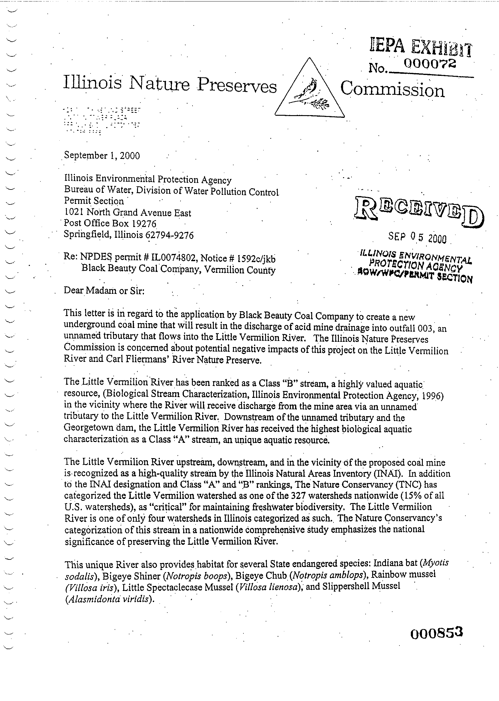
The September 1, 2000 letter of Carolyn Taft Grosboll, Executive Director of the Illinois
Nature Preserve Commission, to the IEPA Water Pollution Control Division, Permit
Section has and continues to play a prominent role in the adjudication of the Permit, Ms
.
Grosboll has admitted in sworn depositions that
this letter were drafted in their entirety by
Commission employee Mary Kay Solecke, a three-year member of Appellant .
Aside from
the threatening and coercive tone of the Grosboll/Solecke letters, Ms . Grosboll's
September 1, 2000 letter misleadingly cited the Illinois Natural Areas Inventory as an
authority for denying or limiting the Permit without disclosing that the INAI began its
report with the caveat that the Little Vermilion River has been subject to continuing
effects of human activities for at least 150 years
.
[Fred Hubbard to confirm reference to
INAI]
According to her testimony, Ms . Grosboll did not suspect at the time that she was
being used by Ms. Solecke to implement Appellant's agenda, and perhaps to set up
grounds for this appeal
.
This document is printed on recycled paper .
4
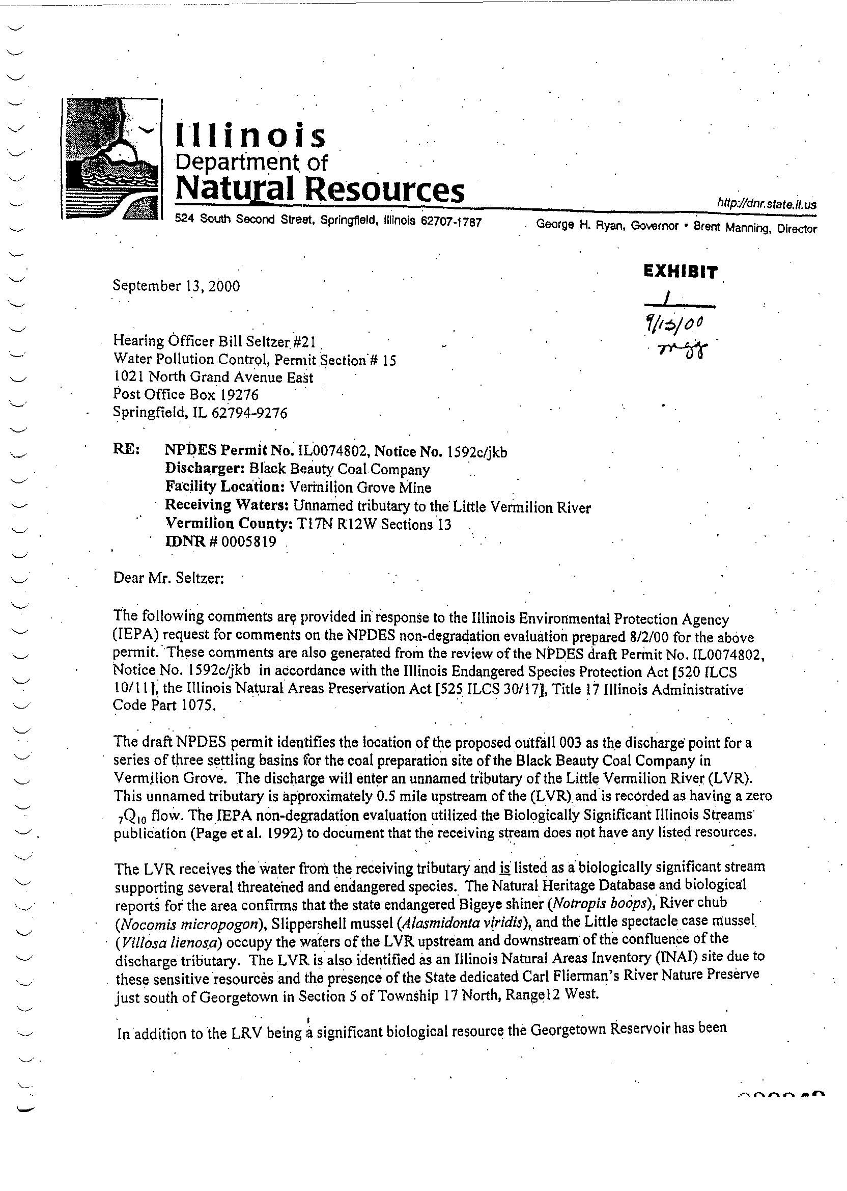
The conduct of IDNR's Endangered Species Office is perhaps the most troubling of the
numerous apparent conflicts of interest in the records of the Agencies that forms the
evidentiary basis for this Appeal. Deanna Glosser, the director of the JDNR Endangered
Species office during the pendency of the Permit application, sent a strongly worded letter
on Department letterhead to IEPA hearing Officer Seltzer, with copies to many other
IEPA and IDNR officials. Ms. Glosser's letter dwelt on the proposed antidegradation
regulations now pending before the IPCB, even though those regulations are not
applicable to the Vermilion Grove NPDES permit. Patrick Malone, a Glosser subordinate,
busied himself to provide legal research in regard to unlawful takings, which suggests this
was their intent all along
.
Both the Glosser and Grosboll letters knowingly, falsely, and willfully stated that the
permitted discharge would result in significant degradation during dry periods, even
though they were well aware that the discharge would only flow during major storms, and
then to a lesser extent than other watershed contributors . Both cited papers from other
regions to suggest that even minute contacts of water with coal anywhere in the watershed
would have disastrous effects on the Little Vermilion River, even though both were aware
that the LVR naturally flows through the coal seams throughout Vermilion County; and
that a major part of the riverbed in the Carl Flierman's nature preserve is comprised of old
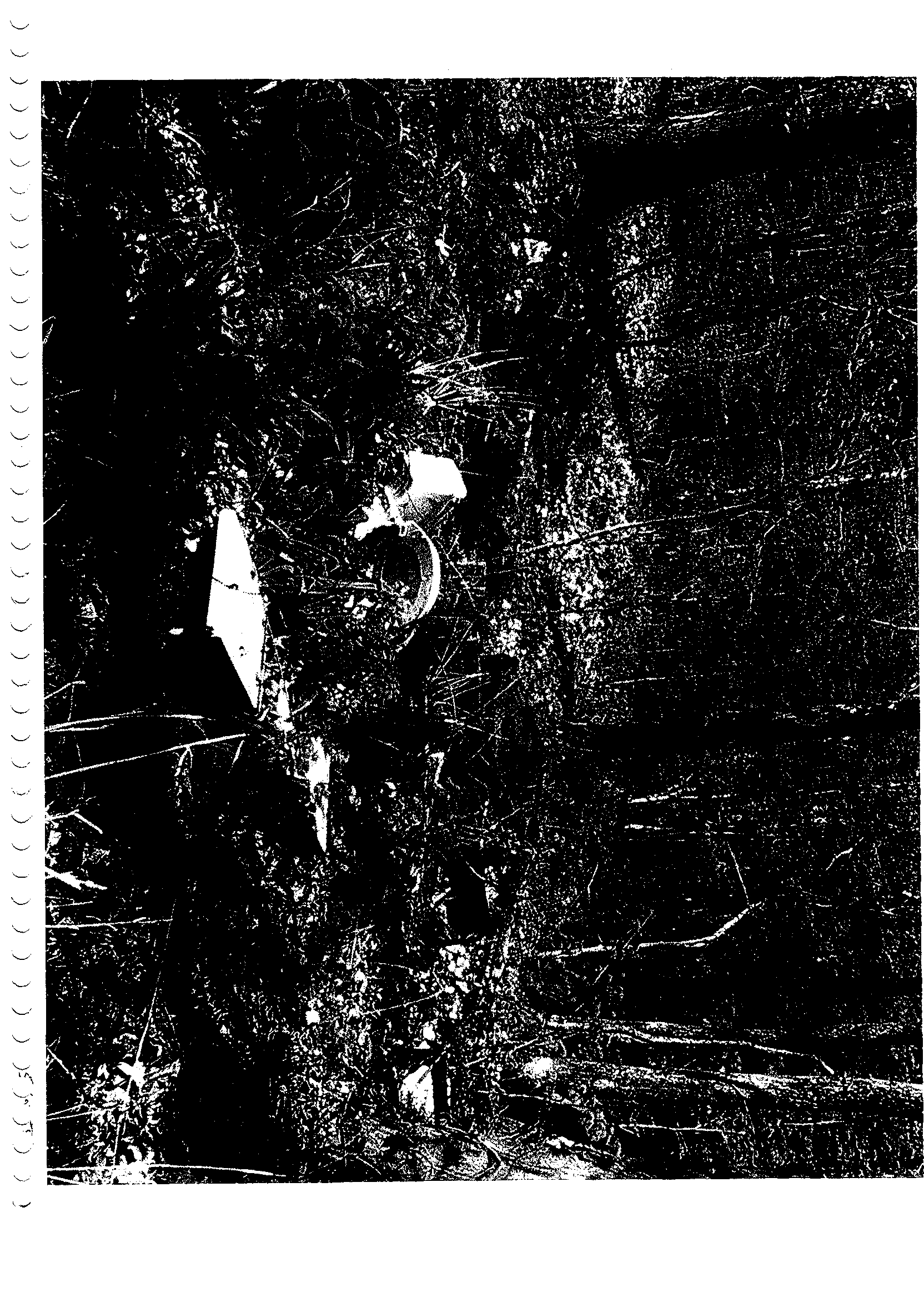
coal mining strip pits (Ex. D). As illustrated by the photograph in Ex . G, Vermilion Grove
area residents seem to have viewed the unnamed tributary as a disposal area for old white
goods .
.
Appellant and the Environmental Law and Policy Center have not acted as responsible
advocates in this matter ; rather they have misrepresented facts, co-opted employees of
Illinois regulatory agencies; and generally abused the privilege they have been afforded as
responsible environmental organizations . The Executive Director of Appellant, made false
and defamatory statements without bothering to conduct or obtain any scientific or
engineering analysis. He himself is unqualified by education or experience to hold a
technically or managerially demanding position . His main qualifications seems to be a
smarmy, vaguely defined affection for rivers ; and a gift for inflammatory rhetoric. Any
pending or future comments or contribution by these persons or entities should be
regarded by the IL PCB as prejudiced, lacking in objectivity, and aimed at misusing the
regulatory process to achieve mainly political goals
.
The conduct of Appellant and its counsel, Environmental Law & Policy Center, suggests
that they and certain individuals politically activist persons within the IEPA and IDNR are
acting in concert to set up the Black Beauty Permit matter as a "Poster Child" that
illustrates the dire need for stricter antidegradation regulations . Any future efforts by them
to influence Illinois antidegradation rules should be viewed with great skepticism
.
Appellant has failed to meet its burden of proof in this matter . Further, Appellant has acted
in bad faith. Equity demands equity. Vermilion Coal Company respectfully requests that
the appeal be denied in its entirety
.
This document is printed on recycled paper
.
5
This document is printed on recycled paper
.
Wil
E. Stephe
Vic President
6
Before the Illinois Pollution Control Board, Case PCBOI-112
Prairie Rivers Network v IEPA and Black Beauty Coal Company
Exhibit List to Public Comments of Vermilion Coal Company
Exhibit A :
IL PCB Rulemaking Proceedings (1980)
Exhibit B
:
IL PCB Rulemaking Proceedings (1983)
Exhibit C
:
Plan View of Vermilion Grove Mine Water Treatment Facilities
Exhibit D :
Little Vermilion Riverbed Map Showing Old Strip Pits
Exhibit E :
September 1, 2000 Letter of Carolyn Grosboll (IEPA Ex. 72)
Exhibit F :
September 12, 2000 Letter of Deanna Glosser (1EPA Ex . 1)
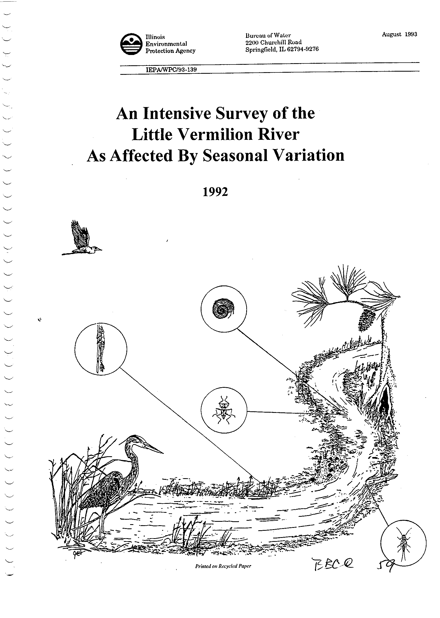
Exhibit G:
Photo of LVR Unnamed Tributary Showing Discarded White Goods
Exhibit H
:
Biologically Significant Illinois Streams (Page 25, 1992) (IEPAIWPC/93-
139)
This document is printed on recycled paper .
7
Exhibit A
I
v
APR.19.2001
12:47PM
OPINIONPY :
[*1]
SATCHELL
OPINION: PROPOSED OPINION OF THE BOARD (by Dr . Satchell)
:
This' matter comes before the Board upon two proposals for regulatory change .
On September 21, 1976 Ohio Power Company filed a petition for a change in the
definition of mine storage facility, docketed R76-20 . On April 20, 1977 the
Environmental Protection Agency (Agency) filed a petition proposing to repeal
Chapter 4 : Mine Related Pollution and substitute a new version, docketed R77-10,
On~August 18, 1977 the proceedings were consolidated on motion of Ohio Power
Company, The proposal in R76-20 was published in Environmental Register Number
135 on August 15, 1976, R77-10 was published in Environmental Register Number
146 on May 2, 1977 . Public hearings on the proposal were held
in Springfield on
October 31, 1977 and in Carbondale on November 2 and 3, 1977 . During the course
of these hearings, two amended proposals were presented by the Agency
.
On November 21, 1978, the Institute of Natural Resources (Institute), pursuant
to suggestion made by the Illinois Coal Association at the merit hearings, filed
with .the Board a proposal for interim regulations (R . 141) . On December 14,
1978 the Board ordered the record in this [*2] proceeding held open to take
evidence on the proposal for an interim regulation concerning total dissolved
solids in mine discharge (Rule 605 ; 32 PCB 321)
.
An Economic Impact Study (EcIS) was prepared by the Institute . Public
hearings on the EcIS were held in Springfield on July 31 and in Carbondale on
August 2, 1979
.
At these
hearings
evidence was also taken on the merits of the
Institute's interim proposal . On September 5, 1979 the Agency filed a third
amended proposal . on October 2, 1979 the Illinois Coal Association filed
a
set
of comments . On October 4, 1979 Monterey Coal Company filed its comments .
On
that same date the Illinois Mine Related Pollution Task Force filed a position
paper. On October 11, 1979 the Board received the comment of Directors Michael
Mauzy of the Agency and Brad Evilsizer of the Illinois Department of Mines and
Minerals .
The
hearings
were attended
by
members of the public and representatives of
-various coal companies and the Illinois Coal Association (Coal Association)
.
some of the latter were also members of the Task Force . The industry
representatives presented testimony and cross-examined witnesses
.
SUMMARY OF PROPOSED CHANGES
The Chapter [*3] 4 revisions, drafted on the Order dated December 1$,, 1979,
are largely to accommodate the NPDES permit requirement . Currently mines
require two environmental permits in Illinois : they must have a Chapter 4 state
LEXSEE 1990 111. ENV LEXIS 379
IN THE MATTER OF: PROPOSED AMENDMENTS TO CHAPTER 4 OF THE
REGULATIONS OF THE ILLINOIS POLLUTION
Nos . R76-20 ; 77-10
Illinois Pollution control Board
2980 111. ENV LEXIS 379
January 24, 1980
CONTROL BOARD
NO . 663
P. 2/34
.J
APR.19.2001
12:47PM
NO.683
P.3/34
permit,
and, in most cases, an NPDES permit under Chapter 3, The new Chapter 4
provides specifically for Chapter 4 NPDES permits . The Agency regards this
permit requirement as essentially duplicative . The new Chapter 4 will exempt
from the state permit requirement those mines which hold an NPDES permit (Rule
402)
.
The proposal also contains a significant expansion of the scope of Chapter 4
to include coal transfer stations . This was the. proposal of Ohio Power Company
which was denominated R76-20 and consolidated with the Agency's proposal . This
will allow coal transfer and similar facilities to take advantage of the more
lenient effluent standards contained in Part VI of Chapter 4 (Rule 201 ; "Mining
Activities") . Since the inclusion of coal transfer facilities under Chapter 4
would represent a significant expansion of the permit requirement, there are
also provided exemptions from the permit requirement for smaller facilities
(Rule 403)
.
,
The Affluent limitations contained [*4] in Chapter 4 have been revised to
more closely follow the federal guidelines . The averaging rule has also been
changed to be similar to that found in federal guidelines and in the proposal in
R76-21 (Rules 601, 606) .
The present Chapter 4 requires an abandonment permit before a mine is
abandoned. The Agency has found these provisions to be unworkable . The new
Chapter 4 will provide for an abandonment plan which is filed with the permit
application and incorporated into the permit as a condition (Rule 509)
.
Most of the technical rules governing coal mining have been removed from
Chapter 4 . The remaining document is largely procedural. There is, however,
provisign for publication of an Agency guidance document which would contain
design criteria for coal mines and treatment works (Rule 5D1) . There in a
similar provision in the water rules (Water Pollution Rule 967)
.
Most of the controversy has controversy has centered around Rule 605 which is
unchanged from the old Chapter 4 . This rule requires that coal mine effluents
not cause violation of the water quality standards contained in Chapter 3
.
Apparently most of the coal mines in the state cause such water quality
violations [*5] with respect to total
dissolved
solids (TD5), chloride and
sulfate . Late in the proceeding the Institute of Natural Resources and the
Agency proposed a temporary rule to exempt coal mines from Rule 605 into the
year 1981, at which time the Institute intends to propose an alternative to Rule
605 (32 pCB 321) . In the interim, compliance will be required with good
housekeeping practices contained in a code of good mining practices promulgated
by a joint government-industry task farce,
STATE OR NPDES PERMIT
Although elimination of duplicate permits and provision 'for exemption from
the state permit requirements will result in dollar savings to the Agency and to
the industry, it adds considerable complexity to Chapter 4 . A facility carrying
out mining activities may fall into one of the following categories
:
1 . Combined Chapter 3 and Chapter 4 NPDES permit
;
2, chapter 4 NPDES permit
;
3. State permit ; or
4. Exempt from state permit (and not required to have an NPDES permit)
.
The following outline determines into which permit category a facility will
fall
:
RPR.19.2001
12:47PM
NO.683
P.4/34
1
.
bogs the applicant already possess a Chapter 4 state or NPDES permit for the
facility?
-- If so, is [*6] permit modification
required
under Rules 304(b) or 407?
2 . If not, does the applicant propose to carry out "mining activities" within
the meaning of Rule 201?
-- It the applicant does not propose to carry out mining activities a Chapter 4
permit is not required under Rule 401
.
3 . If the application proposes raining activities, then does the applicant
already possess a Chapter 3 NPDES permit for the facility [Rule 402(a)]?
-- If so, then the chapter 4 requirements will be written into the Chapter 3
NPDES permit (Rule 302)
.
4. If the applicant has no
NPDES
permit, then does the application propose a
discharge from a point source into navigable waters within the meaning of the
FWPCA (Rule 402)?
-- If so, then under Rules 300(a) and 302 the requirements of chapter 3 and
Chapter 4 will be written into one NPDES permit fox the facility subject to the
standard for permit issuance contained in Rule 502 .
5 . If an NPDES permit is neither held nor required, then does the facility
qualify for an exemption from the state permit requirement under Rule 403?
-- If not, a state permit is required under Rule 401
.
6 . If go, has the Agency notified the facility that a state [*7] permit is
nevertheless required under Rule 403(c)?
-- If
so,
a state permit will be written pursuant to Rule 401, subject to the
general standard for permit issuance contained in Rule 502 ; otherwise, a Chapter
4 permit is not required, provided the operator notifies the Agency of the
location of the facility and claims exemption prior to the filing of an
enforcement action [Rule 403(b)]
.
There are also construction permits (Rule 401) and construction
authorizations (Rule 304) . These are special, limited state and
NPDES
permits,
respectively. in the case of a facility which already has a Chapter 4 permit,
their issuance will amount to a permit modification in the above outline. In
the case of a new chapter 4 facility, the state or NPDES permit first issued
will ordinarily be a construction permit or authorization, although there is
flexibility on this point
.
ECONOMIC IMPACT STUDY
The Economic Impact Study was prepared for the Institute by
Dr .
William C.
Hood and Dr. Donald W. Lybecker, The study found few identifiable costs and
benefits and concluded that the economic impact of proposed changes would be
minimal. The specific findings will be discussed with the individual [*8]
sections which were found to have an economic impact
.
The transcripts of the two sets of hearings are not numbered sequentially
.
It is therefore necessary to distinguish page numbers . "E" refers to a page
RPR.19 .2001 12:48PM
number in the economic impact hearings, while "R" refers to a page number in the
merit hearings
.
AGE1'CY PROPOSAL
At the hearings it was suggested that the Agency's proposal needed to be more
carefully drawn (R. 119) . It was further suggested that for clarity it was
desirable to separate the provisions applicable to : (1) NPOES permits, (2) state
permits and (3) both (R. 100) . The Agency's response to these criticisms was
three amended proposals which adjusted specific rules to meet specific
objections. The Agency suggested that the editorial changes were up to the
Board (R. 120) . Accordingly, the Board has regrouped the provisions from the
arrangement in the Agency proposal . After the proposal had been rearranged it
became apparent that its lack of structure had hidden a number of circular
definitions and conflicting provisions. An effort has been made to eliminate
these difficulties, Specific alterations in the Agency's proposal will be
discussed with each section. [*9] To aid in cross referencing the proposed
opinion and order to the proposal and the old Chapter 4, the comparable section
numbers have been listed in parentheses after the heading of each rule in this
Opinion, For example, "P-305" refers to Rule 305 in the Agency proposal and "0-
605" is Rule 605 in the old Chapter 4 .
PART I : GENERAL PROVISIONS
101 Authority (y-101; 0-101)
Rule 101 sets forth the Board's authority to regulate mine related pollution
under !3 13 12 and 13 of the Act which concern water pollution . The old chapter
4 also listed 13 13 9, 21, and 22 of the Act which related to air pollution and
land pollution and refuse disposal. These have been omitted from the revision,
Mining activities are subject to these provisions of the Act and to the Board
regulations adopted under them -- Chapter 2 : Air Pollution Control Regulations
and Chapter 7 : Solid Waste Rules and Regulations, as well as other Board
regulations (R. 43)
.
Mine refuse disposal is regulated by Chapter 4 pursuant to 13 12(d) of the
Act which
concerns
depositing contaminants upon the land so as
to cause a water
pollution hazard. It is arguable that mine refuse is also "refuse" within the
meaning of 13 13 21 and [*10] 22 . However, it is not the Board's intention that
disposal of mine refuse on a permitted Chapter 4 facility be subject to Chapter
7 as well as Chapter 4 .
Since chapter 3 and Chapter 4 both govern water pollution there mubt be
special rules establishing the respective jurisdictions . Chapter 4 governs
mining activities which include mine related facilities as defined by Rule 201
.
Part VI establishes effluent limits for mine discharges (Rule 600), Other
discharges and facilities are regulated under Chapter 3
.
102 Policy (P-102 ; 0-102)
This is largely unchanged from the Agency proposal and the old Chapter 4
.
The wording has been changed to include the defined terms "mining activities"
and "mine related facility" (R . 201)
.
103 Purpose (P-103 ; 0-102)
This has been taken largely unchanged from the second paragraph of old Rule
102
.
NO.683
P.5/34
h
HYK.17.c 4l 1G ; 4ChT1
NO.683
P
.6/34
104 Compliance with other Laws Required (P-105 ; 0-701)
This has been changed to indicate required compliance with "The Surface Coal
Mining Land Conservation and Reclamation Act ." The title of the law passed in
1979 differs slightly from the old title (R . 43, 58, 67)
.
105 Validity Not Affected (P-106 ; 0-702)
This is unchanged .
106 Repealer [*119
This has been added to the
Agency
Proposal. There is a proviso that if the
entire Chapter 4 is found invalid or if its enforcement
is
stayed, then the old
Chapter 4 will again come into effect . There is also a provision in Rule 704
which continues the abandonment permit requirements of old Rule 502 until
permits containing abandonment plans are issued,
PART II : DEFINITIONS
200 Terms Defined Elsewhere
This contains a listing of terms used
in Chapter 4 which are defined in the
Act, Chapter 3 or the FWPCA .
201 Definitions
Abandon : The definition of abandon has
been
enlarged to include "transfer of
ownersh.i,p," An operator who sells a mine may be obliged to execute an
abandonment plan under Rule 509 . Under the old Chapter 4 persons attempted to
evade their responsibilities for properly closing a site by transfer to a party
with insufficient resources to close the site . This change seeks to remedy this
(R. 9, ; E. 41)
.
The Agency proposal included "fail to open" under the definition of
abandonment. This has been deleted on the Agency's motion . Failure to open
will not therefore require execution of the abandonment plan . However, any
construction activity related to [*l21 preparation for mining amounts to
opening a mine. Therefore, execution of the abandonment plan will be required
unless the operator takes no action whatsoever preparatory to mining
.
Acid-producing Material: The definition has been changed slightly to clarify
the relationship between pyrite, iron and sulfur. Pyritic compounds include
pyrite, marcaSite and other compounds of iron and sulfur. These are acid-
producing. Other compounds of sulfur include sulfates and organic sulfur,
Sulfates are totally oxidized and hence do not, as such, produce acid . Organic
and elemental sulfur do not occur in large amounts in Illinois coal, but are
acid-producing. The definition has also been changed slightly to specify
consideration of the "quality of drainage produced by mining on sites with
similar soils ." This is in recognition of the fact that little mining actually
.occurs
in
the soil itself (R. 84)
.
Affected Land: The definition has been expanded to include all land owned,
controlled or used by the operator in connection With mining activities with the
exception of the surface area above underground mines. The old definition
included
only the actual mined area, refuse area, etc, [*13) The definition
has also been altered to exclude land once it has been reclaimed and abandoned
to the satisfaction of the .Agency
(R,
10) . Under Rule 513 the affected land
cannot be outside the permit area during the permit term .
H-'K . 17
. eoul
le ;4
C""1
NO.683
P.7/34
Coal Transfer Facilities or Coal Storage 3'ard: This is a new definition
.
Transfer and storage facilities have been included in the definitions of mining
activities and mine related facilities and have thus been brought under chapter
4 regulation. These facilities have much in common with coal mines and often
are larger than small mines and pose a similar pollution threat. Effluents from
these facilities will now be regulated under Part
VI
rather than under Chapter
3, Facilities which have ItPDES permits will now fall under Part IZI rather than
the permitting provisions of Chapter 3. Facilities which are not required to
have NPDES permits may be required to obtain a state permit under Part IV (R
.
10, 19, 60 ; E. 41, 45, 49, 61, 101)
.
This modification potentially represents a large expansion of the permit
requirement. However, Rule 403 provides exemptions from the state permit
requirements for domestic retail sales yards and consumer stockpiles . [*14]
Larger facilities are probably already required to have an NPDES permit,
in
which event Chapter 4 provisions will be written into the Chapter 3 permit .
The Agency proposal specified that coal transfer facilities and coal storage
yards were included not only in the definition of "mining activity," but also in
"mining" and "mine area." This usage was in conflict with the general
definitions of these terms in the proposal and it is not clear what its purpose
was . These have therefore been deleted . However, the definition has been
expanded to specify that transfer facilities and coal storage yards are "mine
related facilities ."
The Economic impact study concluded that inclusion of coal transfer
facilities and Storage yards under Chapter 4 would result both in costs and
benefits to the industry. They would have to prepare an abandonment plan at a
cost of a few hundred to a few thousand dollars . On the other hand, they will
not have to invest as much to construct larger treatment facilities to meet the
more stringent effluent standards of Chapter 3 (ECIS 35 ; E . 41, 45, 61) . The
looser effluent standards would have some negative effect on the environment
.
However, most of these facilities [*15] are located near major rivers where
ample dilution is available (ECIS 17; N . 49, 101) .
Construction Authorization: Authorization under Rule 304 to prepare land for
mining activities or to construct mine related facilities. Construction
authorization is issued to a person who holds or is required to have an NPDES
permit (R, 11) .
Construction Permit: A permit under Rule 401 allowing the operator to prepare to
carry out mining activities or to construct mine related facilities
(R.11) . A
construction permit is a state permit issued to an operator who does not hold an
NPDES permit . Under Rule 304 it is possible to issue a construction permit to a
person
who
may be required to apply for an NPDES permit . This will not affect
the requirement to obtain an NPDES permit for operation, but may simplify
administration in case there is doubt as to which type of permit is required
.
Construction of mine related facilities is a mining activity . Construction
may therefore be permitted by an operating permit as well as a construction
permit, The question is not what the title of the permit is but what the
.language of the permit allows, The construction permit is a special type of
[*16] operating permit which will usually be issued for a short period of time
to allow the operator to undertake something out of the ordinary routine of
mining. The construction permit contemplates eventual application for an
operating permit before daily operation is begun
.
It would be better to exclude from the definition of mining activities the
construction of mine related facilities . Mining could be separated neatly into
two worlds of construction and operation, each with its own permit . However,
v ,i"y
I
HrN . 17. eUW1 lei 41
imll
NO.683
P . 8/34
such definition would be difficult because mining is essentially an ongoing
construction process. It is not the Board's intent to require operators to make
continuous application for construction permits or authorizations as mining
proceeds (Comments of coal Association)
.
Domestic Retail Sales Yard: A coal stockpile which supplies only homeowners,
businesses or small industries or other institutions for individual consumption
.
This dges not include a sales yard located at a mine or mine related facility .
On the Agency's motion, a specific exclusion for sales yards which supply large
industrial operations has been excluded from the proposal . The word "small" has
been inserted (*17] in front of industries in the first half of the definition
.
This does not change the meaning (R. 11, 28; E. 43)
.
Domestic retail sales yards are excluded from the state permit requirement by
Rule 403 . This does not, however, exempt such a facility from the requirement
of obtaining an NPDES permit if the facility is otherwise required to obtain
such a permit, in which case the coal pile will be permitted under Part III of
Chapter IV (E. 84)
.
Drainage Course: Definition unchanged
.
Facility: This definition has been added to the Agency proposal . The term
was used in that proposal, although undefined, along with "mine," "mining
facility," and "operation ." A facility is a contiguous area of land, including
all structures above or below ground, which is owned or controlled by one
person. Two permits are required if there are either two isolated pieces of
land with one operator or adjacent tracts with two operators
.
The definition of mining activity in the proposal specified "activities on
land owned or controlled by the operator
.
.
.
." This has been changed to
"activities on a facility ." The implication that a permit is limited to one
operator on one site is now contained [*18]
in the definition of facility .
The one-site/one-operator limitation, although self-evident, is of central
importance deserving clarification in a separate definition . Furthermore, it is
logically remote from the definition of mining activity, except to the extent
that offsite activities are not mining activities within the meaning of chapter
4 .
The facility may be larger than the affected land. It may include
undisturbed land and contain within it facilities which are regulated under
Chapter 3 as well as mine related facilities . The permit area must be contained
within qne facility, but the permit area may be less than the entire facility,
It
is
the Board's intention that a site under control of one operator but
bisected by a roadway or other easement should be one facility . In the event
there nee two closely related, but noncontiguous facilities under the control of
one operator, the Agency may allow a combined permit application and issue
combined permits, it it is convenient to do so . In the event there are separate
surface installations serving a single mine, there will be one facility .
The phrase "owned or controlled" does not require permits of both the owner
of record [*19] title and, for instance, a lessee. However, in the event
control of mining activities is in dispute, the owner may be required to obtain
a permit also. Otherwise the permit will be required of the person in control
of the mining activities . The fact that two or more persons may be in control
of part of the facility is irrelevant so long as only one controls mining
activities ;
e.g ., utility easements or farm operations have no effect on
"control" for the purpose of determining the extent of the facility
.
During the hearings the Agency sought to amend the proposed definition of
"operator" to specifically include co-op preparation plants (R. 12, 29; Agency
I
I
U
N
N-
N-
H'K.1J.Gbd1
1e :4`J~'M
NO.683
P .9/34
Amendment)
.
The argument had been made that, since there was no one operator,
Chapter 4 was not applicable to the co-op . However, "operator" has been
redefined to include any person who carries out mining activities . The question
centers not on the legal character of the person, but on whether he carries out
mining activities . Even if a co-op falls under no other characterization in the
definition of "person" in the Act, then it will probably be a partnership within
the meaning of Chapter 106 1/2, b 6, Illinois Revised Statutes . [*20] If the
facility if physically separated, then multiple permits may be required .
However, if one site is operated by several persons, the
Agency
may require them
to enter into a formal agreement fixing control prior to permit issuance,
Mine Area or Mined Area : Although the definition is largely unchanged, it has
been altered to exclude the unmined surface land directly above underground mine
workings that is not otherwise disturbed by mining activities . The changes in
wording more clearly state the definition (R . 91)
.
Mine Discharge: Part VT regulates mine discharges . The production of a mine
discharge is a mining activity . The AGency proposal did not include a
definition of mine discharge . This definition has been taken from Rule 600 (P-
301) . Since the definition is fairly long it was thought better to set it forth
in definitions and then simply use the term "mine discharge" in Part VI .
The proposal brings preparation and milling plant effluents into Chapter 4
for the first time (R . 15) . The definition has also been expanded somewhat to
include discharge from affected land and runoff from land . The Agency
definition was somewhat more limited in scope. This [*21] may have been
inadvertently omitted from the Agency proposal since it is contained in the old
version of Chapter 4 [0-601(a), P-301(a)] (R. 51),
Coal mining is closely connected with activities affecting the land, The
exclusion of runoff from part of the affected land from Chapter 4 regulation
could have unintended results . It could be argued under the Agency proposal
that runoff from the affected land other than from the mining area or the mine
refuse area or processing plant, etc., would be regulated by Chapter 3. This
could be used to justify required segregation of waste streams where there was
no sound environmental reason for doing so . This is not intended, however, to
limit the Agency's power under Rule 604 to require segregation of waste streams,
A definition of other discharges is also included. These include sanitary
sewers and discharges. from facilities and activities which are not directly
related to mining activities . Other discharges are regulated under Chapter 3
.
If a facility with an NPDES permit has both mine discharges and other
discharges, they will be regulated by Chapter 4 or Chapter 3 respectively,
although there will be one permit only (Rule 302) . [*22]
Mine Refuse; Definition unchanged (R . 48)
.
Mine Refuse Area : Definition unchanged .
Mine Refuse Pile ; Definition unchanged .
Mine pelated Facility : A portion of a facility which is related to mining
activities, This is a new definition taken from the Agency's amended proposal,
the rule on construction authorization (Rule 304 ; P-204) . That amendment
required a construction permit for "any facilities related to mining
activities ." This has been shortened to "mine related facility" and used
throughout . There may be several mine related facilities within a facility .
There may also be other facilities, including facilities regulated under Chapter
3
.
Mining : The Agency proposal contained an exception from the definition of
mining for "dredging operations contained solely in natural bodies of water ." In
WK .
1
7
.6601
n:buHM
NO.683
P.10/34
a letter to the Board dated September 26, 1917 the Illinois Department of
Conservation objected to this exemption, At the hearings the Agency was unable
to explain why this was excluded from the definition of mining (R . 97), This
exception has therefore been deleted from the proposal . These operations may,
however, be exempt from the state permit requirement under [*23] Rule 403 . An
example of a regulated dredging operation is found in Votava v . Material Service
Corp., 2<d> District, #78-489 (July 19, 1979)
.
The wording of the definition has been somewhat changed to include the
surface and underground extraction or processing of natural deposits of coal,
clay, fluorspar, gravel, lead bearing ores, sand, stone, peat, zinc bearing ores
or other minerals, It was pointed out at the hearing that lead and zinc do not
occur in their native state in Illinois and that peat is mined in Illinois (R
.
93)
.
Mining Activities : All activities on a facility which are directly in
furtherance of mining. This definition, together with the permit requirement of
Rule 401, defines the scope of Chapter 4 (R . 11, 70) . The Agency's definition
has been essentially adopted . However, a listing of specific mining activities
mentioned
in the proposal have been listed with the definition
.
The Agency proposal contained many permit requirements (P-200, 201, 204, 251,
256, 257, 259, 260, 261, 262, 263 and 265) . All of these were in conflict with
the requirement of an operating permit to carry out mining activities . Many
also conflicted with other permit requirements [*24] through the use of
different language to cover similar activities . These have been brought
together under the definition of mining activities . There is now only one
permit requirement, the state permits of Rule 401 . NPDES permits have been made
an exception to Rule 401, This has eliminated conflicting language and provides
a simple statement of the scope of Chapter 4
.
The Agency's proposal contained several rules stating generally that a permit
was required to carry out mining activities or to carry out a special type of
mining activity, The proposed Chapter 4 contains several rules of the form : "Do
not do
A
or
B,"
where B'is a subset of A . These have been retained for clarity
even thqugh they are redundant (Rules 304, 400, 401, 501, 502, 505) . It is
possible to interpret this As excluding the special type from the definition of
mining activity. Therefore the definition of mining activities has been altered
to make it clear that the special type is still a mining activity
.
Opening a Mine : Any construction activity related to the preparation for
mining on a facility. This is a new definition . Once a mine has been opened,
it cannot be abandoned without execution of the [*25] abandonment plan as
provided by Rule 510 (R. 11) . Outstanding permits for mines which have never
been opened expire on the effective date of this Chapter as provided by Rule
703 . Permits issued in the future will include a definite expiration date as
provided-,by Rules 301 and 409 .
The Agency proposal specified preparation for mining on "the affected land ."
This has been changed to "facility" to avoid logical problems since the land
cannot b~ affected prior to opening a mine .
opening a mine is a mining activity and hence a state permit, construction or
operating, is required under Rule 401 . A construction permit is required by
that section to 'Prepare to carry out mining activities or construct a mine
related facility which could generate refuse, result in a discharge or have the
potential to cause water pollution
.
.
." ordinarily a permit will be obtained
before the mine is opened . Whether a permit is required for construction
activity preliminary to that specified in Rule 401 depends on intent . Turning a
spadeful of earth or driving a nail with the intent of ultimately mining is
opening
a
mine, which is a mining activity requiring a state permit . However,
N --
HYK. nh ca61 1Z SL~rn
NO .683
P . 1 1/34
the question of [*26) intent vani§hes once i,t can be said that a mine related
facility has been constructed which could generate refuse,
etc. in this case a
construction permit is required even if the operator has no intention of mining
.
Operating Permit : A state permit required of a person carrying out mining
activities as required by Rule 401 . An operating permit is not required for a
person holding an NPDpS permit as provided by Rule 402 . Other exemptions from
state permit requirements are provided by Rule 403
.
Construction permits and operating permits are referred to jointly and
severally as state permits . Since mining activities include construction, an
operating permit may authorize construction. There is no legal significance to
the designation "operating permit" or "construction permit ." The language of the
permit controls what is permitted
.
Operator: A person who carries out mining activities . An operator must have
a state, permit under Rule 401 unless one of the exemptions of Rules 402 and 403
applies
.
The definition has been considerably shortened from the Agency proposal which
listed various sorts of persons . This list is quite similar to that found in
the definition of "person" [*27] found in the Act . This term has been
substituted for the list for
clarity. it is doubtful the Board has the power to
regulate any person who falls outside the scope of the Act (R. 12)
.
The proposal specified "engages in mining or the generation or disposal of
mine refuse or the operation of any coal storage yard or stockpile area ." This
has been expanded to include all mining activities, The listed practices have
been moved to the definition of mining activities
.
under the Agency proposal state permits were required of operators who
carried out mining activities (P-251, 256, 257) . Apparently there were two
tests: Was the person an operator; and, (or?) was he carrying out mining
activities? This confusion has been eliminated by making the permit requirement
depend on the definition of mining activity only
.
Permittee: A person who holds a state or NPDES permit. This is a new term
taken
from
the new Reclamation Law. The Agency proposal spoke of "persons" and
"operators ." Where from the context a rule seems to apply only to permit holders
the term "permittee" has been substituted . A person who holds a combined
chapter 3 and Chapter 4 NPDES permit will be a "permittee" since (*28]
he
will
hold an NPDES permit issued under Chapter 4
.
Slurry: This definition has been somewhat changed and expanded to include
mill tailings
.
Spoil: This definition is unchanged, but has been clarified to include
"mineral seams or other deposits." This is in recognition of the fact that some
minerals do not occur in seams, but occur in lenses or other formations
(R .
99)
.
State Permit : A construction permit or operating permit
.
Surface Drainage Control ; This definition has been added to the original
proposal. An Agency amendment expanded the scope of
Rule 505 beyond diversion
of surface water around the active mining area to include diversion around mine
refuse areas and diversion, redirection or impoundment of streams . At this
point it became simpler to define a term for use in the operative rule .
Surface drainage control also includes flow augmentation and controlled
release
cf
effluents . These are suggested methods of avoiding violation of the
TDS
water quality standards which involve stream diversion and/or impoundment
.
They
wild.
require a permit under Rule 401
.
nrrs.l~.cr~n .t
lc',srl'I
NO.683
P . 12/34
surface Mining: Definition unchanged
.
Consideration has been given to bringing this definition [*29) into line
with the similar definition in the Reclamation Act. However, that act refers
only tq,coal mining, while chapter 4 covers mining activities in general . It is
the Hoard's intention to include "surface mining operations" as defined by f3
1.03(24) of the Reclamation Act within the definition of "surface mining" used
in chapter 4
.
Underground Mining: The definition has been changed slightly for
clarification
(R .
12),
Underground Water Resources : Definition unchanged .
Use of Acid-producing Mine Refuse : This definition is derived from the
Agency's proposal (Rule 508; P-259) . Use of acid-producing mine refuse has been
included in the definition of "mining activity" and the permit requirement, by
implication, moved to Rule 401: State Permits . . Under the old Chapter 4, use of
acid-producing mine refuse was illegal (0-404) . under the proposal, the Agency
may issµe permits (R. 112)
.
PART IIT : NPDES PERMITS
300 Preamble (P-200)
The wording of the original proposal has been changed to clarify the
NPDES/state permit relationship. Part III applies to mining activities carried
out by
any
person who holds an NPDES permit, regardless of whether he is
required to have [*30) an NPDES permit because of his mining activities . This
part dogs not seek to alter the law of who must obtain an NPDES permit .
However, it a person must obtain an NPDES permit, the Chapter 4 requirements
will be written into that permit (R . 12, 19
(
69, 100, 103, 167 ; S. 43, 82, 84)
.
Take, for example, a large mining operation which would not be subject to the
NPDES permit requirements except for a small sanitary waste facility . 14 the
sanitary waste facility must have an NPDES permit, then the entire facility is
governed by Part III and any Chapter 4 requirements will be written into the
NPDES permit. The facility will be exempt from the requirement of obtaining a
state permit under Rule 402
.
Part III also applies
to
mining activities carried out by persons required to
obtain an NPDES permit
.
It
will be a violation of Part
III
to carry out mining
activities without an NPDES permit if those activities are required to have such
a permit. In this case there will also be a violation of Part IV since the
exemption from obtaining a state permit will not be applicable if there is no
NPDES permit .
301 Incorporation of NPDES Water Rules (P-202)
Except to the extent contradicted [*31) in chapter 4, the rules contained in
subpart A of Part IX of Chapter 3 apply to Chapter 4 NPDES permits. This
incorporates Rules 901-916 of Chapter 3 into Chapter 4 . The permit requirement
of Rule 90'1 is identical to the permit requirement of Rule 302 . The application
requirement of Rule 902 has been supplanted by the requirements of Rule 504
.
Rule 903' is incorporated. Rules 904 through 909 set forth the permit
applications procedure before the Agency, These are generally incorporated
except to the extent they may be contradicted .
Rule 910(a) on general conditions is included in Chapter 4 subject to the
special conditions and Agency guidance document provided by Rule 501 . Rules
910(b), (c) and (d) concerning water quality standards, wasteload allocation,
RHH .1'$.2001
12:51PM
NO. 583
P.13/34
effluent limitations and new source standards of performance are included
.
Rules 910(e),
(f),
(q) and (h) concerning duration of permits, reporting and
monitoring, entry and inspection, schedules of inspection and compliance are
included. Rules 910(i) and (j) are generally incorporated. Rule 910 (k) on
maintenance and equipment
is
incorporated subject to the Agency guidance
document of Rule 501, Rules 910(1) and (m) on [*323 toxic pollutants and deep
well disposal are incorporated . Rule 910(n) on authorization to construct is
'supplanted by Rule 304 .
Rules 911 through 915 are generally included . These are appeal, authority to
suspend, modify or revoke, revision of scheduled compliance, variance and public
access to information. Rule 916, effective date, is not applicable
.
Rule 301 generally incorporates procedural rules applicable to NPDES permit
applications except to the extent that these are contradicted by the more
particular provisions applicable to mines . This is to be contrasted to Rule 600
which concerns the applicability of the effluent and water quality standards of
Parts II, III and IV of Chapter 3 . The standards contained in chapter 3 are
generally inapplicable to mine discharges unless otherwise provided,
302 NPDES Permit Required of Certain Discharges (P-201)
Rule 302 establishes the requirement of an NPDES permit for a Chapter 4
discharger. This merely repeats Rule 901 of Chapter 3 and the requirements of
section 301(a) of the FWPCA as applicable to mining activities
.
The Agency proposal also specified that an NPDES permit was required of all
discharges of pollutants or combination [*33] of pollutants from all point
sources as defined in the FWPCA into navigable waters . The Board does not
disagree with this statement of the NPDES permit requirement. However, this
language has been omitted out of concern that it might be construed not as a
guideline to aid persons unfamiliar with the permit requirement but as a new
standard for the permit requirement. It
is
not the Board's intention to change
the-NPDES requirements in this Chapter 4 . Whether the permit is required will
be judged solely by Chapter 3 and the FWPCA
.
303 Application (P-203)
Rule 303 requires a person to apply for an NPDRS permit if he is to engage in
a mininglactivity requiring such a permit . This rule contradicts the present
Rule 902(c) of Chapter 3 .
303(b) makes it clear that a person who has applied for an NPDES permit need
not apply for a state permit. If a person is in doubt as to whether an NPDES or
state permit is required, he
should
first apply for an NPDES permit. If the
Agency determines that a state permit is required, it will notify the person and
request dim to apply for a state permit . There will be no penalty for
application for the wrong permit
.
303(b) will also be applicable [*34) in the event the Agency loses NPDES
authority and notifies the permit holders that state permits are required as
provided by, Rule 402,
304 Construction Authorization (P-204)
Rule $04(b) provides for modification of a mining activity or mine related
facility for which the operator already holds an NPDES permit . Modification can
be undertaken only pursuant to a construction authorization which will take the
form of a condition of a new or supplemental NPDES permit (R . 13, 66)
.
HVK.1y.Gbb1 n :51HM
Rule 304(a) covers the more complicated case in which a person
:
1. Seeks to open a mine for which an NPDES permit will or may be required ; or
2. Seeks to modify a facility in such a manner that an NPDES permit will be
required after the modification but was not before, either because it operated
under
a
state permit or was exempt; or
3. Seeks to modify a facility in such a manner as to bring part of it under
Chapter 4 where the facility prior to modification held an NPDES permit but was
regulated under Chapter 3
.
Rule 304(b) covers the usual situation in which a person,operating under an
NPDES permit seeks to modify . This will be handled exclusively with a
construction authorization . However, [*35] flexibility is allowed in the less
common situation involving new construction which will bring a facility under
Chapter 4 for the first time. These situations could result in
confusion .
They
may be handled either by construction authorization or state construction permit
as provided by Rule 401 . Rule 304(c) provides that application must be made at
least 180 days in advance . Rule 304(d) provides that a person seeking
construction authorization will proceed just as though he were applying for an
NPDES permit . The Agency may provide construction criteria in its guidance
document promulgated pursuant to Rule 501 .
The original proposal contained a requirement that the construction
authorization not cause a violation of the conditions of the NPDES permit . This
has been deleted. The standard for issuance of a construction authorization
will be the same as the standard for the issuance of a permit, The question
will be
whether
the modified facility will cause a violation of the Act or
Rules, if not, the conditions of the permit will be adjusted to allow the
modification. Similar requirements have been dropped from USEPA regulations [40
C.F.R. b 124 .52(b) ; 44 Fed. Reg. 32,854, [*36] 32,899 (June 7, 1979)]
.
However, Rule 301 incorporates a similar provision from the present Rule 902(i)
of Chapter 3 . On December 13, 1979 the Board proposed to delete this in R79-13,
The Agency proposal was also specifically conditioned on the validity of
existing permits . This has been deleted as unnecessary . The term permit always
means valid permit unless otherwise specified . Subsequent to the hearings the
Agency proposed an amended version of this rule [P-204(a)]
.
This amendment has
been substantially adopted in altered form
.
Deleted (P-205)
The Agency proposal contained a rule listing the rules which were applicable
to NPDES permits (P-205) . This rule has been deleted since the chapter has been
restructured to make this clear (R . 101)
.
PART IV; STATE PERMITS
400 Preamble [P-250 ; 0-203(a)]
Part IV governs in theory all mining activity and hence anything regulated
under Chapter 4. However, the exemptions for holders of NPDES permits and for
domestic retail sales yards, consumer stockpiles and some small mines will, as
things presently stand, relegate Part IV to a minor role (R . 69) . However, in
the event the Agency loses NPDES authority, this will become the [*37]
principal part of Chapter IV
.
401 Construction and operating Permits : State Permits (P-251, 256, 257 ; 0-201)
NO.683
P
. 14/34
RPR.19.2001
12:52PM
NO.683
P.15/34
Rule 401
sets forth the requirements of state permits. There are two types
of state permits
-- construction permits and operating permits . These are
referred to individually or collectively as state permits (A . 12) . Rule 401(c)
provides for a joint construction and operating permit to be issued whenever it
is not worth the administrative trouble to issue separate permits
.
An operating permit is required for a person to carry out mining activities,
The definition of mining activities includes construction activities . Therefore
an operating permit is sufficient for construction . However, Rule 401(a)
provides for a separate construction permit. There has been difficulty with the
old Chapter 4 in that it is not clear that construction is a mining activity
.
In some cases, coal has actually been removed from the ground and sold . Persons
have claimed that this was construction and not governed under Chapter 4 so as
to require an operating permit., A construction permit is provided in order to
make this clear (R. 33) .
The separate construction permit will also allow (*38] the Agency to review
and inspect a facility prior to issuance of the operating permit . In some
instances this will provide more flexibility in the permitting process .
It makes no legal difference whether a state permit is denominated a
construction permit or an operating permit . The language of the permit
will
determine what is permitted regardless of the name
.
The Agency's original proposal contained two separate rules for when a
construction permit was required (P-251, 256) . The standard adopted is from the
Agency's amended proposal (A .P .-251)
.
The standard for issuance of a joint permit in the Agency's proposal was that
the activities were "sufficiently standard to obviate the need" for separate
construction and operating permits. This has been changed to allow a joint
permit "for administrative convenience ." The Agency should issue a joint permit
not only when a standard design is involved, but also in the case of an
innovative design if it is more efficient to issue the joint permit . The Agency
may also require two permits even if the design is standard (P-251, 256)
.
The original proposal specified various mining activities for which a permit
was required. This has been (*39] changed to include all mining activities as
defined by Rule 201 . The specifics have been moved to the definition of mining
activities
.
402 Exemption from State Permit : NPDES Bolder (P-252, 200)
Rule 402 provides that an operator who holds an NPDES permit for a facility
need not have a state permit for mining activities on the facility . Whatever
mining activities an NPDES permit holder engages in will be permitted under Part
III (R. 12, 19, 69, 100, 167 ; E. 84) . The NPDES exemption will terminate when
and if the Agency ceases to administer the NPDES permit program . The Agency's
proposal set forth the requirements of the PWPCA and specified that the
exemption would not apply unless they were met . Even though the exemption and
the Agency's NPDES authority might be conditioned upon the same facts, this
construction would raise the possibility of an inconsistent determination of the
facts. The proposal has been changed to provide that the exemption ceases
whenever the Agency ceases to administer the program for any reason whatsoever
.
Rule 402(b) also provides for notice to the NPDES permit holders by the
Agency in the event the Agency ceases to administer the program. This (*40]
is the only way of guaranteeing that the permit holders will learn that a state
permit is required. The notification procedure also allows the Agency to
determine whether or not it has NPDES authority . The agency need not give
notice until it is convinced it has actually lost the authority with sufficient
APR.19.Z001
12:52PM
NO.683
P.16/34
certainty to justify the inconvenience of processing a large number of state
applications . The wording has also been changed to give the Agency authority to
set dates upon which applications must be received for state permits . It the
Agency, deems it necessary, it may spread these dates out over a period for
administrative convenience
.
The EcIS concluded that elimination of the present system of requiring
duplicate state and NPDES permits would result in an annual savings to the
Agency of $ 3000 to $ 5000 and $ 200 to $ 400 to the mines (E . 43)
.
403 Exemption from State Permit; Coal Piles and Small Mines (P-252)
Rule 403 provides a further exemption from the state permit requirement for
some sfiall mines, domestic retail sales yards and consumer stockpiles located at
the consuming facility, The
revision
has increased the scope of Chapter IV by
including under the definition [*41] of mining activities coal transfer
facilities and coal storage facilities . These definitions would include
domestic retail sales yards and consumer stockpiles . They are also able to take
advantage of the more lenient discharge standards found in Part VI
.
However,
it
would unduly burden retail sales yards to require them to obtain permits (R . 13,
20, 28, 104) . Although consumer stockpiles could include very large facilities,
it is expected that most of these
will
already have NPDES permits. This
provision does not create exemption from the NPDES permit requirement (R . 64; E
.
84) . However, Chapter 4 requirements concerning, for example, a consumer
stockpile will be written into the NPDES permit . The Agency retains the right
to require a state permit in the event a non-NPDES facility threatens to cause
water pollution or violation of the regulations .
Rule 403(a) (3) provides an exemption for any mine affecting less than ten
acres of land per year which is not a coal, fluorspar, lead or zinc mine. it is
contemplated that among other things, this will provide an exemption for small
sand and gravel operations . Since there is a large potential for abuse, the
Board has added to [*42] the Agency's proposal the requirement of notification
by a small mine. This will afford the Agency an opportunity to investigate and
will allow it to maintain an accurate list of mining operations in the state,
Since the exemption will date only from the time the Agency is notified of
the claim of exemption, this provision will be of limited utility as a defense
to operation without a permit, For the exemption to apply, operators who have a
mine with a doubtful exemption will have to notify the Agency and submit
themselves to an
inspection
in advance of an enforcement proceeding .
Rule
403(c) sets forth the requirement that the Agency notify the operator
that a permit is required and that the
exemption
is found inapplicable . In the
event the operator promptly applies for a permit, he can continue operating
without being subject to an enforcement action for operating without a permit
.
404 Applications
:
, Deadline to Apply (P-253)
A
person
who is required
to
have a state permit must tile the application at
least ninety days before the date
on
which the permit is required . This is
similar to rules found
in
Chapter 3 (Rules 902 and 960) . Under the
Administrative Procedure Act, [*43] if a timely permit application is made,
the old permit continues in effect after expiration until the new permit is
issued [x11. Rev. Stat. ch 127, 0 1016 (1977)] . An applicant will not be able
to avail himself of this statute if the application is not filed ninety days
prior to expiration .
405 Permit Applications : Signatures and Authorizations Required (P-254)
HVK . 17.eOO1 1eOt)J M
NO.683
P.17/34
This rule is virtually identical with Rule 902(h) of Chapter 3 which is
applicable to NPDES permits
.
406 Permit Applications : Registered or Certified mail or Hand Delivery Required
(P-255)
This rule is similar to Rule 959 of Chapter 3
.
407 Supplemental State Permits [P-251, 263 ; 0-203(b))
Rule 407 sets forth the rule for when supplemental state permits are
required. Rule 407(a) specifies that an operator may apply for a new or
supplemental permit whenever circumstances arise such that there could be a
violation of the previous permit .
The Agency's amended proposal specified that additional state permits are
required "whenever mine drainage, mining or mine refuse disposal enters an area
not covered by a previous permit or when the treatment or pollution control
plans ate modified in design or operation" (AD-251) . [*44] This provoked
comment from the Illinois Coal Association and
Monterey
Coal Company. They
objected to dropping the word "substantially" before "modified in design or
operation" and to the proposal to require a supplemental permit whenever the
mine
entered
any "area" as opposed to a "new drainage area ."
The supplemental permit requirement on entering a new drainage area is taken
from the old Chapter 4 [0-203(b)) . Under that rule an operator could mine for
an indefinite period at a given location once a permit was issued . The only
limitation was a new permit when a new drainage area was entered . The new
Chapter 4 is different in that the permit can have a duration of not more than
five years, It is possible to project the progress of the mining with greater
specificity for a limited period of time . Therefore, Rule 513 has been added to
the Agency's proposal, This requires that a state or
NPDES
permit specify a
permit area, the maximum,
extent
of the affected land during the permit term .
From the coal operators' comments', this appears to make Chapter 4 more in
agreement with the Department of Mines and Minerals' permitting system .
The Agency's proposal contained a substantive [*45) rule requiring
supplemental permits under certain circumstances . However, application for
supplemental
permit is a defensive move on the part of an operator . Therefore ;
a rule requiring a supplemental permit is unnecessary . Rule 407 has been
modified to make it clear that an operator may apply for a new or supplemental
permit whenever a change occurs such that there could be a violation of his
permit .
Under
the Agency proposal, for example, an operator mining beyond the
permitted area would violate not only the rule requiring an additional permit,
but also the rule against violating a permit condition . The redundancy is
unnecessary. The permit should specify with some particularity what it permits
.
If the operator goes outside the bounds of the permit it is a violation of the
permit condition . lie must either cease the activity or apply for a supplemental
permit .
,
Inspection of Chapter 3 reveals no similar rule applying to state permits . A
substantive rule
requiring
supplemental permits is not only unnecessary but is
redundant and conflicts with the various permit requirements contained in Part V
of Chapter 4 . For instance, Rule 506 requires a supplemental permit before
implementation [*46) of a revised disposal plan . Retention of
a
rule requiring
supplemental state permits could also be used as a defense to a complaint
alleging operation in violation of a permit condition not specifically listed in
the rule
requiring
supplemental permits. An operator could contend that under
v
.
HNK . 1:J .eUU1
1C
O
t>d- 1
NO.683
P . 18/34
his circumstances
a supplemental permit was not required and therefore he could
change his method of
operation
without applying for a supplemental permit .
The modified rule gives the Agency control by permit over the supplemental
permit requirement. For example, under Rule 501 the Agency is authorized to
impose special conditions, which could include details of the design and
operation of treatment or po3,lution control plans . The Agency can be more or
less specific about these details in the permit. The degree of specificity will
determine the latitude within which the permittee can operate without making a
supplemental application .
408 Vigiation of
Conditions
or Standards in a Permit (P-270 ; 0-206)
Rule-408 requires operators to comply with conditions of their state permit
.
Rule 400(b) provides for revocation of permits
.
The %gency proposal merely stated that a permit could be revoked (*47]
without giving any standard for revocation . In the Proposed order, four
circumstances warranting permit revocation are listed. These are taken in part
from Rule 912(b) of Chapter 3 and in part by analogy with case law developed in
connection with solid waste permits
. (EPA V . Harold Broverman, et al ., 28 PCB
123, November 10, 1977)
.
in
connection
with an enforcement action, the Board may revoke a state permit
if, because of existing geological conditions, an operator cannot carry out
mining activities so as not to cause a violation of the law ; or, the complainant
demonstrates a history of chronic disregard by the permittee of the mining
regulations; or, the complainant demonstrates that the permit was obtained by
misrepresentation or failure to disclose fully all relevant facts ; or, the
complainant demonstrates affirmatively that the general standard for permit
issuance
contained
in Rule 502 would not be met if a new application for permit
were made, This last circumstance is intended to be the converse for the
general standard for permit issuance .
409 State Permit Term [P-268; 0-203(a)]
Rule 409 provides that state permits shall be of a duration not to exceed
five yedrs [*48] as specified in the permit. The Agency may specify any
expiration date up to five years from the effective date of a state permit
(R.267) . The Agency proposal specified that permits had a duration of one to
five years . This has been changed to remove the requirement that the permit
have a duration of at least one year . Rule 910(e), Chapter 3 specifies that
NPDES permits be issued for specific terms not to exceed five years . In the
past the Agency has issued to coal mines NPDES permits expiring less than one
year after issuance. (See EPA V . Zeigler Coal Company, PCB 79-123, Order of
November 1, 1979) . The minimum requirement has been dropped in keeping with the
general
policy of this revision of keeping the NPDES and state permits as
similar gs possible
.
The Agency's proposal specified that operating permits, but not construction
permits, could have such duration except as provided in paragraph d of Section
33 of thA Act. That section establishes the Board's authority to revoke
permits . It is unclear why the Board should not have the authority to
revoke
construction permits also . This exception has been dropped from the rule since
it is not only redundant, but appears [*49] to conflict with the general rule
on revocation of permits found in Rule 407
.
The Agency proposal also contained a provision that all operating permits now
in effect expire when the earliest NPDES permit expires, but not later than
three years after the effective date of this Chapter . This has been moved to
U
HYK
. 17.CLO1
1C Jcsrn
NU . btii
f'. flJ/b4
Part VZI . Not only is this a temporary rule that doesn't belong with the body
of the chapter, but also it does not apply to state permits within the meaning
of Part
IV .
An Agency amendment to the rule on duration of permits which
specifies a 180 day period for abandonment plans after effective date of this
regulation has also been moved to Part VII .
410 Permit No Defense to Certain Violations (P-269 ; 0-207)
Rule 410 provides that possession of a state permit is not a defense except
to a complaint alleging mining activity without a permit. This is similar to
Rule
966 in chapter 3 and Rule 207 of the old Chapter 4 . In an amendment the
Agency also sought to expand this rule to cover NPDES permits, The Hoard
rejects this
change .
Rule 966 of chapter 3 is not applicable to NPDES permits
and there
is
no similar provision covering NPDES permits . Although the Board
has not [*50] so held, there is authority for the proposition that compliance
with the conditions of an NPDES permit is a defense to a complaint charging
violation of related regulations
.
On motion of the Agency, language relating to abandonment plans has been
stricken. Under the original proposal, operator compliance with its abandonment
plan was a defense to abandonment violations . This language was vague and
unnecessary since abandonment plans are covered in Rule 509 (R. 53, 77). The
Illinois Coal Association objected to this proposed modification . However, the
modification is in keeping with the general rule that Illinois permits are no
defense to complaints charging violation of the Act or rules,
411 Permit Review (P-272 ; 0-703)
This follows the general policy of the other Chapters that grant of a permit
with objectionable conditions is a permit denial under section 40 of the Act
allowing the applicant to appeal . This provision is substantially unchanged
from the old Chapter 4, although the language has been altered from that and
from that of the Agency proposal . Language has been inserted providing that
Agency notification of modification or revocation of an existing permit is also
[*51] a permit denial. Rule 503 covers permit modification when new
regulations are adopted. The added language will allow a permit appeal in the
event of Agency notification of modification in such a case. In some cases Rule
503 notification of modification could amount to revocation of the permit
.'
Language has been added to make certain that there is a right to appeal in this
case also .
PART V: STATE AND NPDES PERMITS
500 Preamble
Part V governs mining activities and issuance of permits to operators
regardless of whether they hold a state or NPDES permit,
501 Special Conditions ; Agency Guidance Document (P-261, 266 ; 0-205(c)]
Rule 501(a) allows the Agency to impose special conditions on a permit which
are consistent with the rules and necessary to accomplish the purposes of the
Act. Tha.s restates the Agency's authority under 13 39 of the Act to translate
the body of water pollution law into specific requirements which a discharger
must meet
.
The Agency proposal with regard to special conditions has been reworded to
track the language of 4 39 of the Act [Rule 501(a), P-205(b) and P-266] . The
I
I
HHK . 1:1 .
e0ol
12c b4HM
NO.683
P
. 20/34
requirement found in h 39(a) that permit conditions not be inconsistent with
the [*52] Board rules was not included
in the Agency proposal and has been
added
.
section 39 of the Act sets forth the Agency's authority to impose special
conditions in permits. The wording is slightly different depending on whether
the permit is state or NPDES. Section 39(a), which applies to permits required
by Board regulations, reads as follows: "In granting permits the Agency may
impose such conditions as may be necessary to accomplish the purposes of this
Act, and as are not inconsistent with the regulations promulgated by the Board
hereunder." However, 13 39(b) of the Act sets forth that : "All
IQPDBS
permits
shall contain those terms and conditions, including but not limited to schedules
of compliance, which may be required to accomplish the purposes and provisions
of this Act ." Therefore, assuming J3 39(a) of the Act is inapplicable to NPDES
permits, the Act does not require NPDES permit conditions to be not Inconsistent
with Board regulations. This does not necessarily imply that the Agency must
ignore Board rules in writing NPDES permit conditions . Section 39(a) provides
that the Agency "may impose" conditions necessary to accomplish the Act's
purpose which are not inconsistent (*53] with Board rules . However, 13 39(b)
provides that, in the case of NPDES permits, the Agency "shall impose"
eonditigns required to accomplish the Act's purposes. The Act is silent about
what additional conditions the Agency may impose in NPDES permits
.
Rule 501(b) allows the Agency to adopt permitting procedures . These should
include rules of procedure and application forms . They shall be included in the
Agency guidance document provided for below
.
Rule 501(c) allows the Agency to adopt engineering criteria which will, be
published with the Agency guidance document . These should represent minimal
designs and practices which the Agency will accept for permit issuance
.
Rule 501(e) has been added to the Agency proposal . Although 4 39 of the Act
confers authority on the Agency to adopt rules governing permit procedures, the
Agency has no authority to promulgate substantive rules pursuant to 13 B 12 and
13 of the Act. This authority is given to the Board and there is no authority
for subdelegation to the Agency (E. 80) . Rule 501(e) has been added to clarify
the nature of the criteria which the Agency may promulgate,
The Agency necessarily has the power to develop guidelines for [*54] permit
issuance to be used within the Agency. Rules 501(c) and (d) contemplate
publication of these guidelines as criteria . The criteria will represent a
formal statement of what the Agency will not challenge in a permit application
.
The criteria are not rules and will not bind any party other than the Agency
.
Although these are not rules in the usual sense of the word, they are rules
within the meaning of the Administrative Procedure Act, Ill . Rev. Stat . ch. 127,
3 1003 .09
:
"Rule" means each Agency statement
of
general applicability that implements,
applies, interprets, or prescribes law or policy, but does not include (a)
statements concerning only the internal management of an agency and not
affecting private rights or procedures available to persons or entities outside
the agency, (b) informal advisory rulings issued pursuant to Section 9,
(0)
intra-agency memoranda or (d) the prescription of standardized forms
.
The c;iteria will amount to an Agency statement that interprets law or
policy. They will be of general applicability and not informal advisory rulings
issued to individual petitioners as contemplated by !3 1009 of ch . 127
.
Publication of the rules in conformity with (*55] the Administrative Practices
Act is therefore required (E . 82; Third Amended Proposal)
.
I
Hr(.17.Gbb1
iCt4VCi
502 Standard for Permit Issuance
Or
Certification (P-267 ; 0-202)
Rule 502(a) sets forth the standard for permit issuance . This is the usual
standard for permit issuance that the operator present evidence to demonstrate
that there will not be a violation of the Act or rules (J3 39 of the Act)
.
Rule 502(b) further sets forth the function of the Agency guidance document
.
Where the guidance document contains criteria with respect to some part-or
condition of the permit, then the applicant may demonstrate conformity with the
criteria of the guidance document in lieu of demonstrating that there
will
be no
violation of the Act or Rules . However, since the guidance document does not
constitute rulemaking, nonconformity with the criteria will not be grounds for
permit denial, provided the general standard for issuance is met. For an Agency
interpretation of the comparable Rule 967 of Chapter 3, see 3 211 . Reg. 36, p .
226 (September 7, 1979)
.
'
As an example of the function of the guidance document, consider that the
Agency might issue criteria to the effect that refuse piles shall have a slope
no I*56] greater than 10% . The permit applicant will be free to •offer evidence
that a slope of 12% under the circumstances will not cause a violation of the
Act or Chapter 4 . However, the Agency will not be allowed to argue that under
the circumstances a maximum slope of 8% is required. The function of the
guidance document is to provide guidance by permitting the Agency to set forth
minimal standards . An applicant can assure himself of prompt permit issuance by
conforming to the criteria of the guidance document .
The Agency's proposal required that as a condition for permit issuance the
applicant demonstrate that he had conformed with all conditions
in
the
construction permit. If such a requirement is to be imposed at all, it should
also be applicable to construction authorizations . However, it has been deleted
from the proposal altogether. The permit will be issued if it is shown that no
violation will occur regardless of whether the applicant conformed to the
conditions of the construction permit . If the applicant breached the
construction permit this will be grounds for an enforcement action, but standing
alone it should not prevent issuance of an operating or NPDES permit if [*57]
the general standard for permit issuance is met . Revocation of the permit
could, however, be imposed as a sanction in the enforcement action in an
appropriate case under Rule 408 or under Rule 916 of
chapter 3 .
503 Permit Modifications when New Regulations Are Adopted (P-271)
Rule 503 provides that the Agency
may
issue a supplemental permit setting
forth affected terms and conditions in the event the Board adopts new
regulations (R. 116) . This has been completely changed from the Agency's
proposal which would have provided for modification of permits by operation of
law. Violation of permit conditions frequently carries more severe penalties
than violation of regulations . The more severe penalties are warranted in part
because the operator has been afforded notice of particular provisions in
regulations by way of the permit and because regulations have been made more
specific when incorporated into the permit . Modification of the permit' by
operation of law would defeat these policies of the permit system . Rule 503 as
adopted conforms with the similar provision contained in Rule 96B of Chapter 3
.
$04 Permit Applications (P-258 ; 0-204)
Rule 504 sets forth what information [*58] must be provided in a permit
application . This is further specified in the sections which follow (E . 26)
.
The Agency proposal specified that soil classification was to be according to
Grandt and Lang, Reclaiming Illinois Strip Coal Land with Legumes and Grasses
.
NO.683
P .21/34
RPR . 19.2001
12:55PM
NO.683
P.22/34
This book is out of print . The Agency will reproduce it
in the guidance
document (R. 106)
.
The Agency proposal specified that the application must comply with the
conditions of the
Agency
guidance document. This has been deleted. If the
Agency were empowered to specify conditions which had to be met, the result
would be an improper delegation of rulemaking authority . However, the Agency is
permitted to
request
more information or more particular information than that
listed in Rule 504 . It may do this either through an application form, the
Agency guidance document or specific requests for information . However, failure
to comply with criteria of the guidance document or inability to supply all
information will not alone be grounds for permit denial absent a showing that
the criteria or information is necessary in the particular case . The Coal
Operators' comment that this is,"beyond the bounds of reason" is answered [*59]
by the requirement of "necessary information,"
Subsequent to the hearings
the
Agency specified certain additional
information. This has been rearranged and incorporated into Rule 504 . The Coal
Operators' comments are discussed in connection with Rule 505
.
505 Surface Drainage Control (P-260 ; 0-301(a), 301(b)]
Rule 505 provides for control of surface drainage by permit. Surface
drainage must be diverted around or away from the active mining area . Other
mining activities and mine refuse disposal must be planned to minimize contact
with waters of the state if such contact could result in pollution . Stream
diversion is to be avoided,
The original proposal provided only for diversion around the active mining
area, An Agency amendment
expanded
the scope of Rule 505 to include diversion,
redirection or impoundment of streams and a rule requiring that mining
activities and deposition of spoil be conducted so as to avoid contact or
interference with waters of the state . These amendments have been incorporated
in altered form,
•
The Agency amendment sought to expand the scope of Rule 505 to afford the
Agency the level of control it presently has under old Rule 301 of Chapter 4
.
[*60] Apparently in its original proposal the Agency restricted its authority
inadvertently .
Some Opecific requirements of old Rule 301 have been omitted . These include
certain mandatory diversion and impoundment provisions . In dropping these
requirements the Hoard does not intend to disavow them . They are mining
practices which carry a risk of water pollution. The Agency may provide for
these matters in the Agency guidance document and may write specific
requirements into permits to prevent water pollution
.
Rules 505(b), (c) and (d) set forth substantive rules governing the conduct
of mining activities . Rule 504(b)(7) requires a plan for surface drainage
control as part of a permit application. This plan will
be incorporated
into
the permit as a condition, Rule 201 defines surface
drainage
control as control
of surfaoe water on the affected land by a person who is engaged in mining
activities. Surface drainage control includes the practices governed by Rule
505(b), (c) and (d) . In permitting surface drainage control, the Agency shall
consider not only whether compliance with the requirements of Rule 505 has been
shown, bit also whether the plan will avoid other violations of [*61] the Act
and Chapter 4
.
The definition of surface drainage control has been expanded to include flow
augmentation and controlled release of effluents as a method of avoiding
violation of the TDS and related water quality standards, These practices may
nr'(.l7.ceei
1~~55rm
NO.683
P
. 23/34
previously have been considered illegal, although this opinion clarifies this
.
They will
require
a permit under Rule 401 since they will involve stream
diversion or impoundment. There is no special rule governing permit issuance in
this case other than the general standard of Rule 502
.
Rule 505(a) requires the Agency to impose a surface drainage plan as a permit
.
condition. The Coal Association objected to this and in general to the
incorporation of the specific rules on stream relocations . Their contention was
that this was provided in the Department of Mines and Minerals permit and
application form which was reviewable by the Agency. They also objected that
the Agency did not presently have control over the permitting of stream
relocations, However, inspection of the old Chapter 4 at Rule 301(a) and (b)
reveals that the Agency does presently have such control
.
At
the
hearings the Agency indicated that the various state agencies [*62]
responsible for permitting coal mines would develop a single application form
which would be circulated. The coal Association's objection that the surface
drainage control provisions would be burdensome is answered by their contention
that the application is already required by Mines and Minerals (R . 27) .
The Coal Association's comments further infer that there is a legislative
intent in the Reclamation Act to exempt coal operators from the permit
requirements of the Act . Of course the bulk of the coal mines are required to
have NPDES permits and the state permit requirement will be inapplicable to
them. It is beyond the power of the state legislature to provide exemptions
from the NPDES permit requirement
.
The Reclamation Act does, as the Coal Association contends, provide for
Agency input and commeht
in
the mines and minerals permitting procedure
.
However, a careful examination of the Reclamation Act indicates that the
Agency's function is advisory. There is no provision for a veto by the Agency
in permit issuance from Mines and Minerals . Furthermore, section 3 .20 of the
"'
Reclamation Act provides that "all requirements of the Illinois Environmental
Protection Act and rules [*63] and regulations thereunder shall be complied
with fully at all times during mining, reclamation and after reclassification ."
The Board cannot find from this a legislative intent to exempt coal mines from
the state permit requirements
.
506 Refuse Disposal (P-262 ; 0-401, 402)
Rule 506(a) requires that a state or NPDES permit contain a refuse disposal
plan, An applicant must submit a plan under Rule 504(b)
(12),
The plan will be
made a permit condition if it satisfies the standard for permit issuance
contained in Rule 502 . The applicant must show that there will be no violation
of the Act or rules, including Rules 504(c), (d) and (e) which are substantive
rules governing mining. The Agency may promulgate mine refuse criteria under
Rule 501
.
Rule 506(e) provides that runoff, etc ., from the affected land must meet the
standards contained in Part VI . Note that runoff from the affected land is a
mine dispharge under Rule 201 [0-401 (a)
(1)] . Rule 506(d) provides that refuse
areas must not be located
in
an area of natural springs or aquifer recharge area
or intercept a drainage course without special protective measures [0-401(a)
(2)]
.
Rule 506(e) establishes rules on spreading [*64] and compacting . These are
reminiscent of the solid waste rules. The original proposal specified only that
acid producing solid mine refuse be spread and compacted and covered when
necessary with "non-acid-producing material . ",This has been modified to include
the word "suitable" before "non-acid-producing material ." Impermeable clay would
I_
U
I
HrK . 17.GGYJ1
LG
•J
Jrrl
NU.b83
H.E4/34
be a suitable cover material in that it would prevent water and air from
reaching the-acid-producing material . However, the Agency may approve
other
suitable materials. Rule 506(e) permits alternate refuse disposal methods at
the Agency's discretion (R . 15, 114) . These will be subject to Rule 502
.
Rule 506(f) and (g) govern revised refuse disposal plans . This establishes a
speciall rule on when a new or supplemental permit is required . A new permit is
required it the revised plan contains any change from the permitted plan . Rule
506(d) requires that a revised disposal plan result in a new permit application
which must be made prior to implementation of the revised plan, ninety days
before for a state permit and 180 days for an NPDES permit
.
The original proposal defined revised disposal plan as one with a
"substantial" change, On the Agency's [*65] motion and over the Coal
Association's objections the word "substantial" has been deleted, A new permit
is required before there is any deviation from the permitted plan . Of course
the Agency can be more or less specific in permit conditions as required to
assure that the
standard
of Rule 502 will be met
.
The original proposal also
required
application to be made ninety or 180 days
prior to "completion" of the plan. The Agency recommended deletion of this
word, but the amended proposal could. still have been interpreted to require
application ninety or 180 days prior to mere possession of the plan . This would
be difficult to administer since submission of a plan is a necessary condition
for the new application under
Rule
504. The adopted rule specifies
"implementation" of the plan, Implementation will occur when the first action
is taken pursuant to the revised plan and contrary to the permitted plan .
507 Experimental Permits for Refuse Disposal (P-264 ; 0-403)
Rule-507 provides for experimental permits for refuse disposal . The standard
for issuanoe of experimental permit is not the same as usually applied to permit
issuances by Rule 502. The experimental permit may issue [*66] if the operator
demonstrates a reasonable chance for compliance with the Act and Chapter 4 . The
rule sets forth special monitoring and reporting requirements . The procedure is
laid out for notice and termination of the experimental permit (R . 114)
.
The original proposal required that the disposal area not be the "principal
area fog disposal of acid-producing refuse unless approved by the Agency." This
language has been deleted. It adds nothing to the proposal since no permit
would issue without Agency approval . It is not the Board's intention, however,
that experimental permits should often be issued for
a
principal disposal area
.
508 Permit for Use of Acid-producing Mine Refuse (P-259 ; 0-404)
Rule 508 requires that a state or NPDES permit include as a condition a plan
for the use of acid-producing mine refuse if the operator is to use such. The
definition of acid-producing mine refuse has been moved from its place in the
proposal to definitions . Use of acid-producing mine refuse is a mining activity
as defined by Rule 201 for which a permit is required under Rule 401 (R . 112),
The original proposal specified that use of acid-producing mine refuse was
restricted to holders [*67) of operating permits . On the Agency's motion, this
requirement has been deleted . There is no obvious reason why this rule should
not also:be applicable to holders of NPDES and construction permits .
Rule 504(b)
(17) requires a plan for use of acid-producing mine refuse in a
permit application. The Agency may set forth in an Agency guidance document
under Rule 501 criteria for the use of acid-producing mine refuse . The standard
I
H'K .1`3.GI~O1
12 5bPM
NO.683
P .25/34
for issuance of a permit for use of acid-producing mine refuse is that contained
in
Rule
502
.
Rule 404 of the old Chapter 4 contained an absolute proscription of use'or
offer of acid-producing mine refuse . This proposal would allow such use by
permit
.
509 Abandonment Plan (P-261 ; 0-502)
Rule 509 provj4ss that an application for a permit include an abandonment
plan. The permit will include an adequate plan as a condition, This represents
a drastic departure from the present chapter 4 which requires an abandonment
permit subsequent to abandonment of the mine, The Agency has had considerable
difficulty with enforcing the requirement of an abandonment permit . Requiring
the abandonment plan will force the operator to confront the problem prior to
abandonment [*681 and the operator will no longer be able to claim ignorance of
the requirement to take steps on abandonment (R . 14, 20, 39, 54, 66, 78, 112)
.
The EcIS was able to quantify the economic costs of this, This represents
one of the few
identifiable
costs associated with this revision . An abandonment
plan likely involves an engineering fee of $ 1000 or more . This fee will have
to be paid prior to application for the permit. This requirement therefore
increases the capital investment required to open a mine and obtain a permit
.
The cost of mining is increased somewhat by the cost of tying up this capital
for the period of time the mine is open (E. 42, 44, 99)
.
Rule 509(b) defines an adequate abandonment plan . The plan must provide a
time schedule for completion of abandonment work within one year. Subsequent to
abandonment, however, the Agency may approve departures from the plan that would
allow for completion over a period of more than one year
.
Rule 509(c) provides that the Agency may further define an adequate
abandonment plan by means of the Agency guidance document . However, the
Agency
must approve an abandonment plan upon a demonstration that it will provide
protection against [*69] violations regardless of whether it conforms with the
Agency guidance document .
Rules 509(d) and (e) provide for revised abandonment plans . A revised
abandonment plan is one constituting a substantial change from the permitted
one. Substantial will be defined on a case by case basis . It will be a
violation if an operator implements a revised abandonment plan without having
applied for a revised permit ninety days, prior to implementation (R . 166, 168)
.
510 Cessation; Suspension or Abandonment (P-361; 0-501(a)1
Rule 510 covers cessation, suspension or abandonment. The original proposal
covered the abandonment plan, permitting requirements and substantive rules on
abandonment in
one
rule, These have been separated into two rules .
Rule 510(a) provides that the operator notify the Agency within thirty days
of abandonment, cessation or suspension of mining . The original proposal
provided that notification was unnecessary if abandonment was caused by a labor
dispute . The language has been clarified and the labor dispute section applies
only to cessation or suspension. The Agency must be notified of abandonment
regardless of the cause
.
Rule 510(b) makes it clear that the operator [*70) must provide interim
impoundment,
etc . to avoid violations of the Act during cessation or suspension
of active mining. The operator will also be required to avoid violations during
excution,of the abandonment plan
.
I
I
I
I
RPR
. 19.2001 12:56PM
Rule 510(c) sets forth the rule that the abandonment plan must be executed
upon abandonment. The definition of abandonment includes transfer of ownership
.
This represents a substantial change from the existing Chapter 4 . In the past
operators have avoided their responsibilities for properly abandoning a
mine
by
transfer of ownership to an insolvent corporation . Such a transfer will be an
abandonment
under the new Chapter 4 and the transfer will not allow the operator
to escape responsibility for adequately closing the site (R . 14, 20, 39, 54, 66,
7B, 11.2)
.
Rule 510(c) provides a defense to
the requirement
to execute
the
abandonment
plan in the event the operator demonstrates that the transfer of ownership was
to a responsible party. A responsible party is
someone
who has already obtained
.
permits to operate the same mine. If the mine is transferred to a party who
does not have a permit at the t~me of transfer but subsequently obtains one, the
transferor will be [*71] relieved of the obligation of further executing the
abandotuttent plan. However, if the transferor has failed to perform part of the
plan during the interim,
there
will have been a breach of the permit condition
which will not be excused
.
It is assumed that a transferree who will be financially unable to execute an
abandonment plan will be unable to obtain the necessary permits to operate the
mine. In particular he will be unable to meet the bonding requirements of the
Mine Reclamation Act,
511 Emergency Procedures to Control Pollution [P-265 ; 0-205(a), 205(b)]
Rule 511 sets forth emergency procedures. The original proposal required
that
the
operator notify the Agency "immediately" of an emergency situation .
The requirement of immediate notification has been changed to notification
within Qne hour . It is feared that immediate notification may be impossible and
hence would not be enforced. it appears that notification within one hour would
be in all events possible and hence
enforceable
(R. 114)
.
The
Agency
proposal was also limited to "sudden discharges ." This has been
changed to include any discharges caused or
threatened
by an emergency. The
Agency should be notified of [*72] any emergency that could result even in a
slow leak .
512 Mine Entrances [0-301(a) and
(c)]
Bore holes, openings, drill holes,
entrances
to underground mines and auger
or punch mine entries must be plugged and sealed to the extent necessary to
avoid the threat of water pollution . This is taken from the old version of
Chapter 4, Rule 301 . It has been added to the Agency proposal on the assumption
that it was inadvertently omitted in the revisions .
513 Permit Area (P-263; 0-203(b)]
Rule 513 requires that a state or NPDES permit specify a permit area . During
permit term no portion of
the
affected land may be outside the permit area
.
This is a new provision which was not in the Agency proposal . The term "permit
area" is taken from the Reclamation Act .
Subsequent to the hearing, the Agency sought to amend its proposal to specify
that additional state permits were required whenever mine drainage, mining or
mine refuse disposal entered an area not covered by a previous permit . The Coal
Association objected to this and apparently construed it to mean a new
application was required each time a shovel took a bite out of a coal seam .
Consideration of this dispute led to the recognition [*73] that there was no
NO. 683
P.26/34
u
I
RPR.19.2001 12:57PM
NO.683
P.27/34
provision in the Agency proposal requiring that the permit specify a
geographical area. Accordingly, Rule 513 has been added to clarify this
.
Under Rule 504(b)(1) the permit applicant must specify the location of the
affected land and the maximum extent of the affected land during the term of the
requested permit. If there is some area in the proximity of the facility into
which mining cannot proceed without violation of the general standard for permit
issuance under Rule 502, the Agency should exclude that area from the permit
area. Otherwise the Agency should grant a permit area which will be consonant
with the permit term .
PART VT: EFFLUENT AND WATER QUALITY STANDARDS (P-301 ; 0-601(a)]
600 Preamble
Part VI applies to mine discharges as defined by Rule 201 . If a mining
activity has both a mine discharge and another discharge, it will be subject to
both Chapter 3 and Chapter 4 . Chapter 4 will govern the mining activities,
including mine discharges . Chapter 3 will govern the other discharges (R . 15)
.
rule 600(b) provides that except to the extent provided in Part VI, Parts II,
III, and IV of chapter 3 are inapplicable to mine discharges . In particular
(*74] the effluent standards of Part IV are inapplicable to mine discharges and
are supplanted by the discharge limitations specified in Rule 606 . The old
Chapter 4 did not make this altogether clear, The parameters of Chapter 3 which
are not mentioned in Rule 606 are unregulated for .mine discharges (E . 56). The
water quality standards of Parts II and
III are incorporated by Rule 605 which
provides for water quality related effluent standards . This is substantially
unchanged from the present Chapter 4 .
Part VI applies to mine discharges from facilities even if they may be exempt
from the state permit requirements under Rule 403 . Likewise Part VI applies to
any incidental mine discharge from a facility which possesses a Chapter 3 NPDES
permit .
601 Averaging (P-301; 0-601(d)]
Rule 601 sets forth the averaging procedure. Compliance with the numerical
standards is determined by averaging 24-hour composite samples over a calendar
month. No 24-hour composite sample may exceed two times the numerical standard
and no grab sample may exceed five times the standard.
On motion of the Agency the period was changed from thirty consecutive days
to a calendar month. This is in line with (*75J federal rules and R76-21
where objection was voiced to the thirty day period . Although the calendar
month is somewhat arbitrary, it is in line with other reporting requirements and
eliminates one degree of
freedom in determining compliance (R . 15, 51; First
Amended Proposal),
This averaging rule is a substantial change from the averaging rule set forth
in
Rule 601(d)(1)
and
( 2) of the old Chapter 4 . The old rule made a distinction
as to whether treatment other than impoundment is provided . Where no other
treatment was provided, the discharge limits had to be met at all times, but
where treatment other than impoundment was provided, the standards were
determined on the basis of 24-hour composite samples with no grab sample over
five times. This has been eliminated
.
In the Agency proposal the averaging rule was contained within the rule on
reporting and monitoring. It has been placed in
a
separate rule to emphasize
importance of averaging and to more clearly distinguish the difference between
I
N
HVK.l7.eee1
lc:5rrn
NO.683
P.28/34
averaging and reporting .
Averaging is a substantive rule of evidence whereas
reporting and monitoring are rules relating to permits and permit
conditions .
in addition, placement of the [*76) averaging rule within the provision for
reduced monitoring and reporting after demonstration of sample reliability
implied that the averaging rule itself could be altered by permit. This is not
the case .
602 Sampling, Reporting and Monitoring (P-301, 302 ; 0-601(b) and
(c),
603, 604]
Rule 602 provides for sampling, reporting and monitoring. A similar
provision is Rule 501 of Chapter 3 . Rules 602(a) and (c) provide for sampling
points. Where treatment is provided, sampling is to
be
between final treatment
and mixture with waters of the state .
Where
treatment is not provided, samples
are to be taken at the nearest point of access, but again before mixture with
the waters . Rule 602(b) provides that the operator shall design and modify
structures so as to permit the taking of effluent samples . The Agency proposal
only required design and modification of "structures for discharging treated
wastes." This has been changed to "structures" in general . It may be necessary
to design or modify structures other than the discharge facility itself in order
to provide access
.
Rule 602(d) provides that an operator report the actual concentration or
level of any parameter identified in the [*77] permit at a reasonable frequency
to be determined by the Agency . The reporting requirement will be specified in
the permit (R . 16) . Recent cases have challenged the authority of the Agency to
require monitoring and reporting of parameters other than those for which
effluent limits are specified in the permit . The intent of this section is that
the Agency may specify not only those parameters for which effluent limits are
set, but also parameters for which water quality levels are set by regulation or
any other parameter it
deems
necessary to have monitored,
Rule 602(e) sets forth that reporting and monitoring are presumptively on the
basis .
or
24-hour composite samples averaged over a calendar month . However, the
Agency may permit lesser reporting . Rule 602(f) provides for monitoring after
abandonment . Rule 602(g) incorporates the VSHPA's current manual of practice .
This was a separate section under the Agency proposal, but it has been included
since it logically relates to reporting and monitoring .
603 Background Concentration (P-303 ; 0-601(e)]
Rule 603 provides that the background level of contaminants in intake water
are not to be deducted in order to determine compliance [*78] with the effluent
standards. This is the same as Rule 601 (e) of the old Chapter 4 and is largely
the same as Rule 401(b) of Chapter 3 (R . 16)
.
Because mining activity necessarily disturbs the land and the flow of water
over and through the land it is the intent of this Chapter to regulate certain
discharges which in other contexts might be deemed background concentrations
.
As used in this Chapter, background concentration does not include contaminants
naturally occurring in underground waters which are brought to the surface as a
result of mining activity or which are pumped from one underground formation to
another, Also it does not include contaminants picked up by surface water as it
flows through the affected area .
604 Dilution (P-304 ; 0-602)
Rule 604 provides that dilution of effluents is not an acceptable
treatment
method. This is similar to Rule 602 of the present Chapter 4 and virtually
identical with Rule 401(a) of Chapter 3 (R . 17, 116) . Language relating to
I
place of sampling has been deleted from the Agency proposal . This language is
also contained in Rule 401(a) in Chapter 3. It has been eliminated because it
is provided in and may conflict with the sampling (*79] point rules provided by
Rule 602
.
The dilution rule interacts with Rule 605 which provides that effluents may
not cagse a violation of water quality standards . In the hearings on this
proposal and in R76-7, concern was expressed that the dilution rule prevents
certain treatment methods for chlorides, sulfates and TDS. In particular it was
feared that controlled release of impounded water was proscribed by this rule .
Controlled release of high TDS water during periods of naturally occurring high
flow in streams is not dilution. In this case the mixing occurs at a point
after the discharge .
Another possible technique
of
avoiding a TDS water quality violation would be
impounding surface water during wet periods and augmenting the flow of the
receiving stream during dry periods to dilute effluents. This would not
constitute a violation of the rule against dilution .
However, it could
constitute surface drainage diversion . A permit would be required under Rule
401
.
I
APR.i9 .2001 12:57PM
605 Violation of Water Quality standards [P-305 ; 0-605(a)]
Rule 605 incorporates the water quality standards contained in Parts IS and
III of Chapter 3 into Chapter 4 . This is the same as Rule 605(a) of the present
[*80] Chapter 4 and is similar to Rule 402 of Chapter 3 .
The second sentence of Rule 605 provides that the Agency shall take
appropriate action under Section 31 or 39 of
the Act. This is redundant because
under the remainder of Chapter 4 the Agency must take such action . However,
certain operators have recently contended before the Board that incorporation of
water quality related effluent standards is not authorized by Hoard regulations .
The second sentence is to make it clear that water quality related effluent
standards can be incorporated into permit conditions (R. 17),
605 .1 Temporary 2xemption from Rule 605
This rule will allow the Agency to issue permits through July 1, 1981 to
authorize discharges which violate Rule 605 by causing water quality violations
of TDS, chloride, sulfate, iron and manganese. For the
remainder
of the
u
discussion of this rule only, these will sometimes be referred to collectively
as 'DDS. An operator desiring such exemption may apply for a new state or NPDHS
permit
containing
the exemption. Rule 605.1(c) sets a special standard for
permit issuance different from that contained in Rule 502 . The burden will be
on the Agency to demonstrate significant [*81] adverse affect on the
environment in and around the receiving water in order to deny the permit, The
operator, however, will have to submit adequate proof that the discharge will
not adversely affect any public water supply. In order to qualify for the
exemption the operator will have to adopt "good mining practices," housekeeping
measures designed to, minimize TDS discharges
.
Rule 605 .1 was first proposed on November 21, 1978 by the institute . This
was after merit hearings on
the
proposal were concluded. On December 14, 1978
the Hoard ordered the record in this case held open to take evidence on Rule
605 .1 . Merit hearings on the proposal were held at the same time as the
economic impact hearings. This proposal has generated the bulk of the
controversy in this proceeding
.
Mine discharges are often high in TDS. Much of this comes from water pumped
from mine areas or runoff from spoil banks .
A substantial number of mines in
NO . 683
P .29/34
U
v
HI'K.1J.GV'JL~1 1:
brn
NO.683
P.38/34
the state produce mine discharges which cause water quality violations in the
receiving streams . Coal mines can seldom be located adjacent to large rivers,
but rather must be located where coal deposits are located. Their discharges
are frequently into [*82] intermittent streams so that the discharge comprises
the bulk of the flow of the stream. Therefore the discharge is limited, not by
the effluent standards of Rule 606, but by the more stringent water quality
standards referenced in from Chapter 3 (R . 129, 142, 151 ;
E
.
6, 11)
.
In a related proceeding, R76-7 the Coal Association sought to exempt coal
mines from application of Rule 605 with respeot-to TDS . Entry of a Final order
in that proceeding has been stayed pending final resolution of this proceeding,
kresently relief from Rule 605 is available only through the variance
procedure. At the hearings, the Coal Association stated that a variance
application can cost as much as'$ 10,000 (E. 126) . There was discussion at the
hearings of a class action variance . However, this was rejected (E . 19, 80)
.
Under the auspices of the Institute a joint Agency/industry group called the
mine Related Pollution Task Force has been formed. The Task Force is conducting
a study to propose an eventual permanent replacement for Rule 605 . It expects
to present this proposal before July 1, 1981 (E . 106)
.
A large amount of earth must be disturbed during the process of coal mining
.
Some of the [*83] TDS
in the discharge results from direct leaching of soluble
minerals from the rock by groundwater or rainwater falling on spoil banks . This
is the source of chlorides, which is not
generally
the main problem
in
Illinois
.
Much of the problem in Illinois is sulfates. These are formed when air or
dissolved oxygen comes into contact with
sulfur-containing minerals
which have
been disturbed. Sulfuric acid is formed, producing acid mine drainage
.
Neutralization of that discharge to moat the pH requirements of Rule 606 may
further
increase
the TDS concentration of the discharge,
The Economic impact Study in R76-7 has
been
incorporated into this proceeding
by reference (E . 103 ; Economic Impact of Dissolved Solids Regulation upon the
Coal Mining Industry, Institute Document No . 77/28) . Although there is
treatment available to reduce the iron and manganese levels, treatment to reduce
the soluble components of TDS is not economically available. Available
technology includes reverse osmosis and distillation . These are energy
intensive and very
expensive
on a scale that would be required to meet most mine
discharges . The Economic impact Study in R76-7 concluded that for the mines in
[*847 the state to meet the present TDS water quality standard would involve a
capital investment of $ 138 .4 million and annual operating costs of $ 37 .4
million (E . 69)
.
The Task Force has promulgated, as an interim measure, a code of good
mining
practices. The approach taken is not end-of-the-pipe treatment of the
discharge, but rather a series of housekeeping measures which are likely to
reduce the TDS concentration resulting from mining activities . These are
summarized on page 4 of Exhibit 4 . These involve practices which may minimize
water from coming in contact with disturbed areas, including bypass diversions,
slope and gradient reduction, stabilization, sealing of bore holes, introduction
of mine barriers, special steps for disposal of potential contaminant producing
materials and fracture zone
sealing,
There are also measures involving
retention and control of waters exposed to disturbed materials, including
erosion and sedimentation controls, reuse of discharges and minimization of
exposure of water to disturbed materials . Other methods include a rerouting of
discharges to larger streams where the dilution would be provided, augmentation
of flow of receiving streams to provide [*85] dilution and controlled release
of effluents during times of high flow when there is ample dilution .
I
HF'K .1'.i.Gb101
1a 58PM
NO.683
P . 31/34
Many of these practices are novel and reliable cost estimates are not
available, Therefore it is not possible at this time to do an actual economic
impact study evaluating the cost of requiring the code of good operating
practices. However, the Board incorporates the Economic Impact Study in R76-7
as an economic impact study on Rule 605 .1. Although that'study does not address
the code of good operating practices, it does conclude that enforcement of the
present standard by requiring end-of-the-pipe treatment would be very expensive
.
There is expert testimony in the record to substantiate that, although the costs
of good operating practices are unknown, they will be substantially loss than
the cost of end-of-the pipe treatment (E . 146)
.
The eventual rule may include some combination of these good housekeeping
procedures together with the proposal to increase the water quality standard for
TDS in intermittent streams receiving coal drainage (E . 73, 110, 128)
.
The Board notes that none of the parties in these proceedings has addressed
the dilution rule (Rule 604) . Part of the [*B6] rationale of the rule against
dilution of effluents goes to accumulation of toxic pollutants . Chlorides and
sulfates are generally soluble and should not accumulate under ordinary
circumstances . Furthermore, they are not at all toxic below a certain
concentration. Therefore, the Board suggests the Task Force consider amending
Rule 604 to allow dilution of effluents by permit where good housekeeping
practices cannot reduce the TDS levels to an acceptable level . However,
dilution of effluents should not be permitted where groundwater must be used for
the dilution or where there is available only surface water which has more
valuable uses
.
Concern was expressed at the hearing that the Board was being asked to adopt
a rule requiring compliance with a code of good operating practices which had
•
not yet been promulgated (E. 111, 134) . Subsequent to the economic impact
hearings, the code was completed and submitted to the Board . Further concern
was expressed that the record was deficient in that there was no technical
testimony to the effect that compliance with the code of good operating
- practices would in fact reduce water pollution (E . 17, 80, 144) . Control of
mining practices which [*87] are not related to the Board's statutory
jurisdiction would, of course, be beyond the Board's authority . Further
consideration of this problem led to the recognition that the proposed version
of Rule 605 .1 required compliance with the code and that this was an
unauthorized delegation of rulemaking authority to the Agency . The proposal has
therefore been rewritten to provide that the Agency issue the exemption if the
operator submits proof that he is utilizing good mining practices designed to
minimize-discharge of TDS. The Agency is authorized to promulgate the code of
good mining practices . Compliance with the code will be deemed evidence that
the operator is utilizing good mining practices . However, should the Agency
deny the exemption due to non-compliance with the code, the operator will be
free on permit appeal to argue that his practices, though not conforming to the
code, are designed to minimize the discharge of TDS . With this construction,
the Board
is
not requiring compliance with the code and therefore technical
evidence to substantiate the code is not required. If provisions of the code
are not reasonably related to prevention of water pollution, this will be an
[*80] issue before the Board upon permit appeal .
Rule 605 .1(b) has been added to the Agency proposal . This provides
specifically that the permittee requesting exemption must file a permit
application. The Agency indicated at the hearing that this was the case and it
has been added to the proposal for clarity (E. 26, 121)
.
The Agency proposal was vague on the question of the burden of proving
adverse effect on the environment . At the hearing the parties agreed that the
Agency should have the burden of demonstrating adverse effects . This is at
RPR.19.2001
12:59PM
NO.683
P.32/34
variance with the usual burden of proof in permit issuance. Section 39 of the
Act provides that it shall be the duty of the Agency to issue such a permit
"upon proof
. that the facility
.
will
not cause a violation of this Act
or regulations hereunder." The Board in this situation is by regulation
reversing the burden of proof (B. 16, 30, 34, 37, 79, 81, 112, 118)
.
At the hearings there was a discussion of whether the intent of the proposal
was that the Agency fix an interim limitation on the TDS . The conclusion was
that under the proposal the Agency could not set such an interim limit . if the
Agency can demonstrate significant adverse [*89] effect on the environment,
then it must deny the exemption . In this case the applicant will have to
proceed by way of the variance route (E . 74, 78)
.
The original proposal specified "significant adverse effects on aquatic life
or existing recreational areas bf the receiving streams ." This has been changed
to "effect on environment in and around the receiving water ." The exemption
should be denied if there is significant adverse
effect
to riparian areas and in
general to the
environment
in and around the receiving water (E. 115)
.
606 Effluent Standards (P-306; 0-606)
Rule 606 sets effluent standards for mine discharges . Rule 606(a) has been
added to the Agency proposal . This makes it clear that the effluent limitations
contained in Part IV of chapter 3 do not apply to mine discharges . This has
always been the law. However, it is not clearly set forth
in
the proposal or
the Old Chapter 4 (E . 56)
.
Compliance with the effluent standards other than acidity and pH is
determined by the averaging rule
contained
in Rule 601 . Compliance is based on
a thirty day average with no 24-hour composite exceeding two times the standard
and no grab sample exceeding five times the standard . [*90]
New Storet numbers have been specified for acidity, ammonia nitrogen, zinc
and fluoride. The old Rule 606 regulated nitrogen at 5 mg/l
whereas
the new
rule specifies ammonia nitrogen, measured as N
.
The standards for zinc, lead and acidity are unchanged except for the Storet
number. The pH range has been tightened from five to ten to
six to
nine
(E. 45,
51) . The EcIS concluded that this would benefit the environment (EcIS 27 ; E .
52) . The cost will be minimal since only one additional mine will be out of
compliance with the new
standard
(ECIS 6, 39)
.
The standard for iron has been decreased from 7 to 3 .5 mg/l and the standard
for total suspended solids (TSS) has been tightened from 50 to 35 mg/l (R . 46,
51, 53) . These changes are environmentally
beneficial
(EcIS 25, 31; E. 51, 53)
.
Under the averaging rule, these standards must be met on a thirty day average
.
They are doubled
when
measured on a daily composite. The new numbers are the
same as,federal
guidelines
applicable to coal mines under 40 CPR 434 . A recent
permit appeal to the Board revealed that there is some dispute as to whether the
federal or the existing Chapter 4 standards are more stringent (Peabody Coal
[*91) Co. v. EPA; PCB 78-296, September 20, 1979) . This is
because
the federal
standard, when coupled with the averaging rule and precipitation
exception,
sometimes yields a higher number on. a 24-hour composite . However, the Board
concludes that it is more difficult to meet the lower thirty day average than
what the discharger must now meet and that this is a more stringent standard
(ECIS 25) . The economic impact will be minimal since most mines subject to the
rule must meet the federal guidelines anyway (EcIS 42)
.
Footnote 3 provides an
exception
for flows resulting from a 10-year, 24-hour
precipitation event. This
exception
applies only to a facility designed,
construgted and maintained to contain or treat discharge from less than a 10-
HYK.17.21Ob1
12:59PM
NO . 683
year, g4-hour precipitation event, but designed to bypass a larger precipitation
event. . This exception is taken from the federal standards of 40 CPR 434 .
Federal mine safety regulations mandate that holding ponds be designed to bypass
such rainfall for safety reasons. This exception has been added in order to
bring the effluent standards into line with these other regulations (E. 47, 56,
124)
.
The original Agency proposal was unclear as to which [*92] parameters were
subject to the exception in footnote 3. During discussion of the EcIS it became
clear that the Agency's intent was that the 10-year, 24-hour footnote apply to
all parameters
except
pH and acidity (E. 124) . The federal guidelines
apparently except pH and acidity also. pH and acidity are not exempt under this
version of
Rule
606. However, one would not expect to see excursions with
respect to these parameters during overflows caused by a large rainfall . The
large rainfall should not result in increased production of acid in disturbed
materials . A large flux of water has some buffer capacity and should dilute the
acidity so as to moderate pH .
The Economic Impact Study found that it would cost $ 40,000 to $ 90,000 per
mine to construct holding basins to contain a 10-year, 24-hour storm (ECIS 42
;
E .
56, 124) . However, this conclusion may be affected by confusion in the
proposal concerning the extent of footnote 3 to Rule 606 . It has been argued by
the
industry that the old Chapter 4 required construction of indefinitely large
holding basins and that 10-year/24-hour basins therefore represent a cost
savings over the present requirements of Chapter 4 (Peabody Coal [*93] Co . v .
EPA, op. cit .)
The fluoride standard has been increased from B
mg/l
to 15 mg/l . In the
hearings evidence was presented to substantiate this relaxation of the standard
.
The old standard was based on experiments which were done in deionized water
containing fluoride. In water containing other ions of hardness equivalent to
typical Illinois mine drainage water, the fluoride is not nearly so toxic to
aquatic life as had been previously believed (R . 117; R. 52)
.
607 Offensive Discharges [P-307; 0-605(b)]
Rule'607 proscribes drainage containing settleable solids, floating debris,
visible oil, grease, scum or sludge solids . Color, odor and turbidity should be
reduced below obvious levels . This is Rule 605(b) of the present chapter 4 and
Rule 404 of Chapter 3 (R . 47, 51) .
608 Deleted (P-308)
The Agency proposal contained a rule to the effect that an operator shall
conduct mining activities so as not to violate the Act and Chapter 4 . This has
been deleted. A number of substantive rules are set forth
in
chapter 4 and the
Act, it is unnecessary to make a rule against violating the other rules
.
Furthermore, a charge in a complaint that an operator had violated this [*94]
rule could be a Violation of due process in that it would not adequately inform
him of what he had done
.
PART VII : COMPLIANCE AND EFFECTIVE DATES
Part VII contains transitional rules covering situations which will arise
after the effective date of Chapter 4 . Rule 701 provides that the Chapter will
become
effective
ten days after filing with the Secretary of State . Rule 703
provides that the state permit requirement of Rule 401 becomes effective only on
expiration of outstanding permits . outstanding permits will expire no later
P
. 33/34
I
RPR.19.2001
1:00PM
NO.683
P.34/34
than three years after the effective date or upon the first' expiration of an
NPDES permit held for the facility
.
Rule 702 provides that a person holding an outstanding permit may make
application for a new permit either before or after the effective date of this
Chapter. It is anticipated that operators of coal transfer and storage
facilities will want new permits . After the effective date the Agency may
require a new permit application on 180 days notice . Rule 703(d) provides for
expiration of the outstanding permit if the application is not made by this
date. Rule 703(c) provides for expiration upon issuance of
a
new state or NPDES
permit for the [*95] facility . if the Agency denies the new permit or takes no
action, the outstanding permit will remain effective for up to three years as
provided by Rule 703(a)
.
The NPDES permit requirement'of Rule 302 is the same as that found in Rule
901 of Chapter 3 . There is no need to stay enforcement of that rule since this
revision does not impose an NPDES permit requirement on any additional
facilities
.
The provisions of Chapter 4, other than Rule 401 : State Permits, are
effective ten days after filing . At this time the other rules of Chapter 4
become immediately effective. This includes all of Part VI, including the new
effluent standards of Rule 606 . Holders of outstanding operating permits may be
subject to enforcement actions based on Rule 606 as provided by Rule 410 even if
their discharges conform with their old permit conditions
.
Rule 704 provides the requirement of old Rule 502 of an abandonment permit
continues to apply to operators who have opened mines prior to the effective
date. This will continue indefinitely until the operator is issued for the
facility a state of NPDES permit which contains an abandonment plan . Such a
permit may be issued under the procedures of Rule [*96] 702 and 703
.
This Opinion, together with the Board Order of December 13, 1979, constitute
the Proposed opinion and order of the Board in this proceeding
.
Exhibit
B
RP": . 13. a i i 12:31PM
OPINIONEY: [*1]
ANDERSON
OPINION; PROPOSED RULE. FIRST NOTICE
PROPOSED OPINION OF THE BOARD (by D . Anderson) :
on February 7, 1983 the Illinois Environmental Protection Agency (Agency)
and
the Illinois Coal Association (1CA) proposed that the Board amend 35 111 . Adm .
Code 405 and 406 to add an effluent standard for manganese and to set a
permanent
rule
specifying the application of water quality standards to coal
mine discharges, Amended proposals were filed
on
May 27 and August 26, 1983
.
The proposal was the result of a joint industry/government group called the
-
Mine-Related Pollution Task Force (MRP)
.
On May 5, 1983 the Board designated this proposal as Docket A of 983-6
.
Docket H was utilized to extend the expiration date of Section 406 .201 beyond
July 1, 1983 (Final Order, Adopted Rule,. Odtober 6, 1.983 ; 7 Ill . Reg. 14515,
October 28, 1983) .
PublLo hearings were held on May 12, 1983 at Springfield, and on May 27, 1983
at Ina. Since the pages are not numbered sequentially, Roman numerals will be
used to indicate the volume, Thus, (11-17) will refer to page 17 Of the second
day of hearings
.
On
July
5, 1983 the
Department
of Energy and Natural Resources notified the
Board that a negative declaration [*2] had been made . On August 26, 1983 the
Hearing Officer closed the record except for final comments (Section 102 .163)
.
No comments were received during this period
.
Summary of the Proposal
The proposal will be discussed in detail in the order of sections affected
.
The following is a summary in a more informative order
.
The proposal adds an effluent standard of 2 .0 mg/l manganese, with a modified
pH standard where necessary for manganese treatment (Section 406 .106) .
The proposal repeals the temporary exemption from the water quality standards
contained in Section 406 .201 . This is replaced with a permanent procedure
.
Mine discharges
will
have permit conditions based on the permanent procedure for
total dissolved solids (TDS), chloride and sulfate if
:
1. There is no impact on public water supplies
;
LEXSEE 1983 111, ENV LBXIS 72
IN THE MATTER OF : PROPOSED AMENDMENTS' TO TITLE 35, SUHTITI,E
D: MINE RELATED WATER POLLUTION, CHAPTER 1, PARTS 405 and
406
No . R83-6 (Docket A)
Illinois Pollution Control Hoard
1983 111 . ENV LEXIS 72
December 15, 1983
NO . 592
P.2/8
AP,R.13.2001
12:31PM
NO . 592
2. The applicant utilizes "good mining practices" to reduce TDS production
;
and,
3. The discharge is less than 1,Q00 mg/l chloride and 3,500 mg/l sulfate
.
If the discharge exceeds the numerical levels, the permittee will need to prove
no adverse effect to the receiving stream (Section 406.203) .
Finally, the proposal extends the TDS water quality provisions to abandoned
mine [*3] impoundments and discharges (Sections 409 .109 and 409 .110)
.
Discussion of Proposed Amendments
Section 405.109 Abandonment Plan
,
Paragraphs
(b)(3)
and (b)(4) have been added, and the old paragraphs with
these numbers moved down. These paragraphs specifically address the impact of
the special TDS provision of Section 406 .203 on discharges from abandoned mines
and on waters remaining in impoundments at such mines, This point first arose
in a case decided during the process of adoption of new Chapter 4
(IBPA
V .
Material Service Corp. and Freeman United coal Mining Co ., PCB 75-488, 31 PCB
275, February 7, 1980)
(1-42)
.
Strip mines frequently leave a final out which fills with water after
abandonment; slurry ponds and other impoundments may also be left
(1-40)
.
Some
of these may have a surface water discharge . Paragraph (b)(3) addresses the
discharge, while paragraph
(b)(4) addresses the waters
in
the lake or
impoundment .
Discharges from abandoned impoundments will have to meet the egflusnt
standards of Section 406 .106. if there was no TDS water quality condition
imposed under special procedures during active mining, the discharge will have
to avoid water quality violations. [*4i If there was such a TDS water quality
condition, the waters of the impoundment will have to meet the effluent
standards and make a part of the showing required under the TDS water quality
Section 406.203(c)(1) and
(c)(2) (I-38 ; II-10, 14, 18)
.
Paragraph
(b)(4) applies to the waters in the impoundments, which may not be
required to meet water quality standards during active mining, as for example,
treatment lagoons and settling basins. Impoundments which
will
not meet such
standards on abandonment will be required to meet the effluent standards after
abandonment, and toe make part of the showing under the TDS water quality Section
406 .203
(c)(1) and
(c)(2)
(11-21)
.
Section 406 .109(b)(4) applies the effluent standards as though they were
water quality standards (I-3B, it-11, 14, 18) . This will be sufficient to
ensure that any discharge will at least meet the effluent standards
.
The second and . third proposals limited the TDS procedure to impoundments
which did not meet the water quality standards during active mining . The Board
has deleted this requirement, since the water quality problems in a final cut
lake may not appear until after abandonment
(1-40)
.
The Board
has
added paragraph [*5] (e) to the proposal ; this requires
conditions in abandonment, plans to assure continued application of the TDS water
quality procedure
(1-37) .
Section 405.110 Cessation, Suspension or Abandonment
Paragraph
(e)(2) has been added to specifically require a showing that
Sections 405 .109(b)(3) and (b)(4) have been met before a certificate of
P. 3/8
NO.592
P.4/8
abandonment is issued. The permittee will have to show that those sections will
be met to get approval of the abandonment plan, and also show that they were in
fact met before the certificate of abandonment is issued (1-37, 11-10, 15)
.
Section 406 .104 Dilution
This section was taken from Section 304 .102, which it tracks almost verbatim
.
Paragraph (a) has been amended to make it clearer that the dilution rule refers
only to the effluent standards. This may have been lost when the language was
moved from Part 304 to Part 406, which deals with both effluent and water
quality standards. Section 302 .102 allows dilution in a mixing zone before
application of the water quality standards
.
The Board does not construe Section 406 .104 as in any way limiting dilution
after treatment in order to avoid, violation of water quality standards . This
dilution CI*6] may take place prior to discharge to waters of the State, so long
as it does not interfere with contaminant removal efficiency (1-62( 61) . If
effluent doncentrations are measured beyond the dilution point, concentrations
would have to be corrected .
Section 406 .105 has been renumbered to 406 .202 : the water quality rule and
special TDS procedure will be placed together in a separate Subpart
.
Section 406 .106 Effluent Standards
An effluent standard of 2 .0 mg/1 manganese has been added to the table
.
Manganeselis frequently regulated as an effluent parameter, and its omission
;Exam the 'revised mine waste rules may have been an oversight caused by the
ambiguity ,l as to whether the effluent standards
table
of old Chapter 4
supplemented or superseded the effluent standards of old Chapter 3
(1-55)
.
The
.
Board regulates manganese in effluents other than mine waste at 1 .0 mg/l
(Section 804 .124) . Federal regulations impose a limitation of 2 .0 mg/1 on
mining activities, including, for example,, the acid mine drainage category (40
CFR 434 .AP(a)),
Tree ant for manganese is similar to iron, involving addition of alkali to
cause pr~pipitation, followed by sufficient detention to allow settling . [*7]
Unlike iron, manganese may be too soluble at pH 9 to precipitate sufficiently to
~mce
'tht! 2.0 mg/1 standard. Effluents will be allowed to. go to pH 10 if
necessary to meet the manganese standard (1-36)
.
(For related discussion, see
Section 304 .125; R76-21, Opinion of September 24, 1981, 43 PCB 367, 6 111 . Reg .
563)
.
The Board regulates manganese as a water quality standard at 1 .0 mg/l
(Section 302 .208) . The standard was based on fish toxicity (R71-14, 3 PCB 755,
4 PCB 3, March 7, 1972) . In her study of several streams impacted by mine
discharges, which is discussed below, Dr. Allison Brigham found that manganese
was found to account for the greatest amount of variance of species diversity
and richness of several variables studied (II-31)
.
The manganese effluent standard will not apply to mine discharges which are
associated with areas whore no mining activities have taken place since May 13,
1976. This date is taken from Federal regulations regulating manganese
discharges from coal mining (1-36, 54; II-10, 12)
.
Section 406 .202 Violation of Water Quality Standards
This Section has been moved from Section 406 .105. Subpart A of Part 406 will
deal only with effluent rules, [*8] while Subpart
B
will deal with water
u
.
u
I
k-nc.1J.ctxii
1G
•o
cr1'I
,
NU.JyG
H
.
t>/6
quality rules .
The TbS procedure of the next Section will thus appear next to
the Section which it modifies .
Section 406 .203 Water Quality-based TDS Permit Conditions
TDS includes all material dissolved in water, as opposed to total suspended
solids. In Illinois coal mine discharges TDS consists mostly of chloride and
sulfate
(1-49)
.
Underground mines often have high chloride levels from saline
water encountered in mining. Surface mines often produce sulfuric acid from the
action of air and water on sulfur minerals exposed in mining . Neutralization of
the acid produces sulfate salts, and further increases the TDS because of the
dissolved solids in the alkali which must be added
.
The problems with treating for TDS have been adequately addressed in prior
Board Opinion
The Board repealed the TDS effluent standard in R76-21, supra,
,
[*9]
in R76-20, 77-10, the Board recognized that coal mines faced a special
problem With TDS in that they produced high TDS discharges, but were often
forced to locate upland, away from major rivers with dilution adequate to avoid
violation of water quality standards . In response, the Board adopted the
temporary exception procedure now found at Section 406 .201 (opinion and Order of
July 24, 1980, 39 PCB 196, 260)
.
The permanent
TDS
rule follows the temporary exemption in some respects : the
applicant is required to demonstrate that he is utilizing "good mining
practice$", and that .,there will be.,;:p„,impact,on public water supplies
(I-30)
.
However, under the permaneri
Pule,
the permittee, ratter •' thaii'the Kod'6cy, will
be required to demonstrate no impact on the receiving stream
.
The TDS procedure creates a presumption of no adverse impact on the stream if
discharge levels are less than 3500 mg/l sulfate and 1000 mg/1 chloride
(I-30) .
if levels are higher, the permittee
will
have to prove. 1gq
.
dverse,
..impact.
This
will involve actual stream StudieC to'be"done
-by
the
permittee, involving a
demonstration of the effect of the existing or proposed discharge levels on the
stream, not a showing [*10] of compliance with water quality standards (I-31,
46,61)
.
I_9,thp.1000.and 4500 mg/l numbers are met, it ,is assumed that there it
qo
adverse impact .on the secdivi.ng'"stream. This
is
a'presumption which could be
rebutted by bth r"widenbe inhroduced into the record in the permit proceeding
before the Agency .
If the water quality-based TDS condition is granted, the discharge will not
be subject to the water quality standards for sulfate, chloride and total
dissolved solids. The permit will Contain conditions requiring monitoring for
these parameters and limiting discharge concentrations (I-47, 11-17)
.
The proposal would have allowed exemption from the water quality standards
for iron and manganese, as well as the TDS related contaminants. The Board has
dropped this from the proposal. The logical relationship between the
presumptive sulfate and chloride levels and the iron and manganese levels is
tenuous at best. Furthermore, there exists a simple, relatively inexpensive way
to treat for iron and manganese. As noted above, manganese concentration was
finding that the only treatment technologies involved large amounts of energy
consumpt4on, and produced concentrated brines which still required ultimate
disposal .
Regulation of TDS discharges was left to enforcement of water quality
standards, of Section 302.208
:
Chloride
500 mg/1
sulfate
500 mg/l
TDS
1000 mg/l
APR.13.2001
12:32PM
NO-592
P.6i8
The presumptive levels refer to concentration of sulfate and chloride, with
no TDS level specified. As a matter of experience, . TDS is mostly these two ions
(1-49)
.
Sulfate and chloride concentrations generally correlate better with
environmental impacts than TDS (1-33; Ex. E, p . 29, 11-32) . Monitoring of TDS
will continue to provide a
check
for the possible presence of large
concentrations of some other matetial (1-41, 11-17)
.
Exhibit E is a study entitled "Acute Toxicity of Chlorides, Sulfates, and
Total Dissolved Solids to Some Fishes in Illinois" by Paula Reed and Ralph Evans
of the State Water Survey . They studied effects of TDS and constituents on
channel catfish fingerlings, large mouth bass fingerlings and blue gill
fingerlins . They found the following 96-hour median tolerance limits (1-33,
Ex. E, P-
129)-
sulfate
11,000 to 13,000 mg/i
Chloride
8,000 to 8,500 mg/l
TDS (sulfate)
14,000 to 17,500 mg/l
TDS (chloride)
13,000 to 15,000 mg/l
The presumptive values for sulfate are Set at about one-third of the 96-hour
[*12] median tolerance limit; those for chloride at about one-eighth
(1-33) .
This is less stringent than the general practice of setting water quality
standards at one-tenth the median tolerance limit (Section 302 .210) ; however,
this departure is justified for these contaminants, which are highly soluble,
not toxic in the usual sense and not expected to accumulate or have any chronic
effect .
The presumptive levels are also well below the levels considered safe for
livestock watering
(1-34)
.
If the discharge is above the presumptive levels, the operator could elect to
treat the effluent, or to obtain a source of fresh water to. dilute it to below
the presumptive levels (1-61, 67) . However; the thrust of the proposal is to
allow permittees to adopt operating practices designed to reduce TDS production,
rather than to require end-of-pipe treatment .
The Agency is to approve the water quality-based TDS condition only if the
permittee proves that it is utilizing "good mining practices" designed to
minimize TDS production . The Agency may promulgate a code of good operating
practices, in which case compliance with the code would be prima facie proof of
use of good mining practices
.
A
"final" (*13] draft o£ the code has been
filed as Exhibit H. The Hoard has proposed Sections 406 .204 through 406 .208 as
a definition of "good mining practices" . These are taken from Exhibit H .
Section 406 .204 defines "good mining practices." The Agency is to consider
whether the operator is utilizing the following practices ;
found to be adversely affecting stream conditions in sites affected by mine
discharges
.
These discharges will have to avoid causing [*11] water quality
violations
:
General Use
Effluent Std,
Water Quality Stdg .
Iron
3.5 mg/1
1 .0 mg/l
Manganese
2.0 mg/l
1 .0 mg/l
HVK . 1ci . Gbb1
1G
.
avr
NO. 592
P . 7/8
1. Practices
which
may stop or minimize water from coming into contact with
disturbed areas
.
2. Retention and control within the site of waters exposed to disturbed
materialp .
3 . Control and treatment of waters discharged from the site
.
4 . Unconventional practices
.
These practices are each further defined in Sections 406.205 through 406 .208 .
These sections are not intended to require that each of these practices be
carried out at each site; indeed, some of the practices would exclude the use of
others . What the Board intends is that the Agency review each of these
practices to determine if the operator is doing all that is economically
reasonable at the site to prevent the production of TDS discharges or to
minimize their impact .
The proposal is in practice a modification to the Illinois NPDES program,
since
all
mines with point source surface discharges [*14) are presently
required to have NPDES permits . Section 302(b) of the Clean Water Act allows
the State to establish procedures whereby dischargers can avoid application of
water quality standards where the discharger demonstrates at a public hearing
that "there is no reasonable relationship between the economic and social costs
and benefits to be obtained ." The procedures of Section 406 .203 will arise in
the context of NPDES permit modification. Hearings required by the Clean Water
Act will be provided pursuant to Section 406 .203(a)
.
Based on the record before it ; the Board has determined that, for coal mine
discharges taken as a class, which have levels of chloride and sulfate less than
the presumptive levels, which are not upstream of public water supplies and
which are engaged in good mining practices, the cost of treatment outweighs the
value of any .improvement in stream quality by many orders of magnitude
.
Surthermore, the societa) costs associated with the effective prohibition of
mining in much of Illinois would be enormous (R 50, 64) . The proposed
procedures allow the Agency to confirm this conclusion in particular cases, with
an opportunity for a public hearing. in the [*15] case of discharges which
exceed the presumptive level, the Agency will make a case-by-case determination
pursuant to permit application including actual stream studies conducted by the
applicant (Proposed Section 406 .203(c)(4)
.
In gone, 1963 there were 45 active coal mines in Illinois, 19 surface and 26
underground. Of these, 31 are operating under the current exemption of Section
406 .201, 14 surface and 17 underground (Agency comment of August 3, 1983 in R83-
6B) . The remaining 14 are assumed to be able to meet the current water quality
standards and are not impacted at all by the permanent TDS procedure .
The 31 mines operating under the temporary exemption should be able to easily
demonstrate that they are using good mining practices and that they are not
adversely impacting public water supplies, since these requirements are not
altered, The mines with less than 1000 mg/1 chloride and 3500 mg/1 sulfate will
qualify under the permanent procedure automatically. The main difference will
be the mines which are above the presumptive levels. They will be required to
demonstrate no adverse impact on the receiving stream. This could cost quite a
lot of money .
If they are unable [*16] to make the showing, expensive
treatment may be required for continued operation .
As noted, the 31 potentially affected mines include 14 surface and 17
underground mines . Sulfate should be the limiting factor for surface, chloride
I
I
H1K Id e[501
1G ; JJM1
NO . 592
P . B/8
for underground mines. It appears that at the time Exhibit C was prepared, no
surface mines exceeded the 3500 mg/l sulfate level, but that four underground
mines' exceeded the 1000 mg/1 chloride level (11-52) . Thus a maximum of four
underground mines are expected to have to make stream studies, These are likely
to cost in excess of $ 10,000 each .
The cost of complying with the Part 302 water quality standards through
application of end-of-pipe treatment technology was discussed at 39 PCB 251 .
Updating these costs to the fourth quarter of 1982 infers construction casts of
$ 195 million and annual operating costs of $ 52 .8 million (11-56) . However,
the number of mines in the State has decreased, possibly reducing the aggregate
estimates . Any Costs associated with compliance with the exemption procedure
must be judged as savings with respect to the cost of current regulations
.
costs of various good mining practices are estimated in Exhibit C, although
[*17[ it is difficult to summarize these concisely . These costs are less than
the cost of treatment by orders of magnitude . The initial costs have already
been met under the temporary rule, although there may be continuing costs
associated with some practices
.
The proposal creates a special TDS water quality rule for a category of
dischargers . The Board has proposed to treat these dischargers differently for
several reasons unique to this industry group. Section 28 of
the
Act allows the
Board •to make "different provisions as required by circumstances for different
contaminant sources and for different geographical areas"
.
At the outset, the Board notes that coal mines represent an easily defined
category of dischargers. It is the only industry group with high TDS discharges
which has made itself known to the Board
by
filing a general proposal . The
Board would consider granting special rules by industry category to any group
should that group propose rules to it (Section 28 of the Act and 35 111 . Adm .
Code 102.120) .
Having defined a category of TDS dischargers, it is possible to be more
specific as to the identity of the TDS constituents : it is either primarily
chloride or sulfate, [*'18] and not often both . This allows the use of
chloride and sulfate toxicity data, which is better defined than, for TDS in
general .
Since there is no economically reasonable treatment available for TDS
discharges, compliance with the water quality standards depends on process
changes and location close to large rivers with adequate dilution . Existing
facilities have the variance and site-specific rulemaking procedures to ease any
difficulties. However, it has proven possible to propose a general regulation
for mines, both new and existing .
The most unique feature of coal mines is their relative inability to locate
close to major rivers; instead, they must locate where coal deposits are
located. Thus choice of location is largely eliminated for this category of
dischargers
.
Restricting consideration to a single industry group allows the Board to
adopt meaningful regulations taking account of
the
processes which produce the
TDS . It would not be feasible to address such a problem for industry
in
general .
Conclusion
In a separate Order the Board proposes to adopt the amendments to 35 Ill
.
Adm. Code 405 and 406 discussed above . The record will remain open for comment
for a period [*191 of 45 days after publication in the Illinois Register .
This Proposed Opinion supports the Board's Proposed order of this date
.
Exhibit C
C
Exhibit D
q1aD
Exhibit
E
Illinois Nature Preserves
September 1, 2000
Illinois Environmental Protection Agency
Bureau of Water, Division of Water Pollution Control
.
Permit Section
1021 North Grand Avenue East
Post Office Box 19276
Springfield, Illinois 62794-9276
Re: NPDES permit # IL0074802, Notice # 1592c/jkb
'Black Beauty Coal Company, Vermilion County
Dear Madam or Sir
:
This letter is in regard to the application by Black Beauty Coal Company to create a new
underground coal mine that will result in the discharge of acid mine drainage into outfall 003, an
unnamed tributary that flows into the Little Vermilion River . The Illinois Nature Preserves
Commission is concerned about potential negative impacts of this project on the Little Vermilion
River and Carl Fliermans' River Nature Preserve
.
The Little Vermilion River has been ranked as a Class "B" stream, a highly valued aquatic .
resource, (Biological Stream Characterization, Illinois Environmental Protection Agency, 1996)
in the vicinity where the River will receive discharge from the mine area via an unnamed
tributary to the Little Vermilion River. Downstream of the unnamed tributary and the
Georgetown dam, the Little Vermilion River has received the highest biological aquatic
characterization as a Class "A" stream, an unique aquatic resource
.
The Little Vermilion River upstream, downstream, and in the vicinity of the proposed coal mine
is recognized as a high-quality stream by the Illinois Natural Areas Inventory (INAI)
. In addition
to the INAI designation and Class "A" and "B" rankings, The Nature Conservancy (TNC) has
categorized the Little Vermilion watershed as one of the 327 watersheds nationwide (15% of all
U.S. watersheds), as "critical" for maintaining freshwater biodiversity . The Little Vermilion
River is one of only four watersheds in Illinois categorized as such., The Nature Conservancy's
categorization of this stream in a nationwide comprehensive study emphasizes the national
significance of preserving the Little Vermilion River .
This unique River also provides
.habitat for several State endangered species : Indiana bat
(Myotis
sodalis),
Bigeye Shiner
(Notropis boops),
Bigeye
Chub.(Notropis amblops),
Rainbow mussel
(Villosa
iris),
Little Spectaclecase Mussel
(Villosa lienosa) ;
and Slippershell Mussel
(Alasmidonta viridis) .
EEPA EX
n
1i
No.
000072
Commission
LUJI
sap
0 5 2000
ILLINOIS ENVIROtiHENT L
PROTECTION ACRNCV
4QW/WPC/PER$T SECTION
000853
Re: NPDES permit A IL0074802, Notice # 1592c/jkb
Black Beauty Coal Company, Vermilion County
Page 2
The Carl Fliermans' River Nature Preserve, an area dedicated as a State nature preserve under the
Illinois Natural Areas Preservation Act (525 ILCS 30), is located on the Little Vermilion River
approximately 2 miles downstream of the location where water from the unnamed tributary flows
into the Little Vermilion River. This Nature Preserve protects a high-quality 1 .2 mile segment of
the Little Vermilion River and . its associated riparian corridor. In addition to protecting a Class
"A" stream that is a unique aquatic resource, this Nature Preserve also supports populations of
Illinois threatened and endangered species including the Bigeye Shiner
(Notropis hoops),
Little
Spectaclecase Mussel
(Villosa lienosa),
and Slippershell Mussel
(Alasmidonta viridis)
.
Carl Fliermans' River Nature Preserve was dedicated as an Illinois Nature Preserve by the
Illinois Nature Preserves Commission to ensure its permanent protection and the perpetuation of
the area in as nearly a natural condition as possible . Areas dedicated as State nature preserves are
to be put to their highest and best use and are held in trust for the benefit of the people of the
State of Illinois. The.Commission is charged with implementing the . Illinois Natural Areas
Preservation Act (525 ILCS 30),.which states it is " .
.
. . public policy off the State of Illinois to
secure for the people
.
. . the benefits of an enduring resource of natural areas
.
.
.
. by establishing
a system
of
nature preserves, protecting nature preserves and
.
.
. otherwise encouraging and
assisting in the preservation of natural areas and features."
The development of
.a new coal mining surface facility in such close proximity to the Little,
Vermilion River is. of significant concern to the Illinois Nature Preserves Commission . The
Commission is concerned about potential negative impacts of the proposed coal mine on the
Little Vermilion River, including the Carl Fliermans' River Nature Preserve . The Little
Vermilion River is an important stream with unusually high fish and wildlife value . This natural
resource should receive protection from any source that could degrade its natural integrity.
After reviewing the permit application, it is our understanding that the sediment basin will result
in a discharge of sediment control effluent after the 24-hour, 10-year storm event. This standard
may be inadequate to prevent water quality degradation to oneof Illinois' most valuable
resources. Considering the frequency of the 10-year event, we believe more stringent measures
need to be taken. Increased storage capacity for the settling basins would ensure that water is
contained during greater storm events before it is released into a tributary of the Little Vermilion
River .
In 1999, IEPA issued a NPDES permit to DynaChem, Inc . of Georgetown, Illinois thatt permitted
stormwater discharge of contact water into a tributary of the Little Vermilion River. At this
facility, the stormwater retention basin was designed to contain the runoff
from
the 100-year
storm event. The applicant originally proposed that the retention basin contain the 25-year storm
event. After IEPA review and public comment, the NPDES permit stipulated that the retention
basin be increased in size to contain the 100-year storm event . IEPA should request that the
Black Beauty Coal Mine sediment control basin be increased in size, just as the DynaChem basin
was increased in size. If this is not done, please explain why it is not deemed necessary.
U
Re: NPDES permit t# IL0074802, Notice # 1592c/jkb
Page 3
Black Beauty Coal Company, Vermilion County
According to an IEPA memo dated Aug. 2, 2000 from Scott Twait to Larry Crispin regarding the
proposed coal mine "dissolved and suspended minerals (manganese, iron, sulfates, and chlorides)
will be present in the settled water discharged during storm events
.
. ." (Page 2, 3`d par
attached). The memo goes on to state that the dissolved and suspended minerals present in the
settled water that is discharged "will be limited in the permit at levels that will be protective of
aquatic life, including threatened and endangered species ." What is the factual basis for this
conclusion?' Have the effects of the specific.minerals contained in the proposed discharge water
been studied on the threatened and endangered species found in the Little Vermilion River?
Please provide citations or references to reports, studies, publications, etc . that support the
conclusion that the dissolved and suspended minerals (manganese, iron, sulfates, and chlorides)'
that will be present, in the settled water discharged during storm events will be at levels that will
be protective of aquatic life, including threatened and endangered species .
The permit proposes to regulate acid mine discharge .using effluent limits prescribed by the
standards for mining discharges . Are these effluent standards adequate to 1) protect the public
water supply of Georgetown, which is taken from Georgetown Lake, located about 1 mile
downstream of the unnamed tributary confluence and 2) assure that no ecological alteration of
the Little Vermilion River will occur? For example, the public notice states that discharge can
contain sulfates with a daily maximum concentration limit
.of 3,500 mg/l. However, general use
water quality standards for sulfates are 500 mg/I. Given the close proximity of the mine to
Georgetown's public water supply and the high natural quality of the Littler Vermilion River,
higher standards for water quality should be considered
.
Have ambient levels of sulfates, chlorides, iron, total suspended solids, manganese, pH,
acidity/alkalinity and settleable solids been determined for the Little Vermilion River? How do'
the proposed permitted levels of these minerals and substances compare to ambient levels? Does
the permit allow higher levels of certain pollutants than are currently in the river?
Alternatives should be seriously considered . For instance, could coal be extracted from aa portal
at the present Riola Mine instead .of creating anew surface facility? Has an analysis
of
alternatives been done?
A social or economic need for this project has not been demonstrated adequately. How many
jobs will be created by this project? Will new workers be hired in addition to those already
present at the Riola Mine? Will Illinois residents have first priority for employment?
On behalf of the Illinois Nature
•Preserve Commission, I respectfully request that a public
hearing be held regarding this permit application due to the high level of public concern
expressed to .the Commission about this project, possible negative impacts on the Little
Vermilion River, including the Carl Fliermans' River Nature Preserve, and possible . negative
.
impacts on aquatic life . found within the river, including State threatened and endangered
animals .
000855
Re: NPDES permit # IL0074802, Notice # 1592c/jkb
Page 4
Black Beauty Coal Company, Vermilion County
Please contact me at 217/785-8686 if I can provide further information or assistance . Thank you
for the opportunity to comment on this important matter. I look forward to your response
.
Sincerely,
Catolyn 1 aft. Grosboll
Director, Illinois Nature Preserves Commission
cc :
Director Brent Manning, IDNR
Rene Cipriano, Office of the Governor
INPC Commissioners
Tom Flattery, IDNIt, Office
of
Realty and Environmental Planning
Deanna Glosser, IDNR, Division of Resource Review and Coordination
Kim Underwood, IDNR, Office of Mines and Minerals
000856
Exhibit F
Illinois
Department. of
Natural Resources
http.-Ildnrsta te. it us
524
South Second Street, Springfield, Illinois
62707-1787
.
George
H .
Ryan, Governor
• Brent Manning, Director
September 13, 2000
Hearing Officer Bill Seltzer. 921
Water Pollution Control, Permit Section 'M 15
1021 North Grand Avenue East
Post Office Box 19276
Springfield, IL 62794-9276
RE: NPDES PermitNo. 110074802, Notice No. 1592c/jkb
Discharger: Black Beauty Coal. Company
Facility Location: Vermilion Grove Mine
Receiving Waters: Unnamed tributary to the Little Vermilion River
Vermilion County : T17N R12W Sections 13
IDNR # 0005819
Dear Mr. Seltzer :
The following comments arg provided
in
response to the Illinois Environmental Protection Agency
(IEPA) request for comments on the NPDES non-degradation evaluation prepared 8/2/00 for the above
permit. These comments are also generated from the review of the NPDES draft Permit No . IL0074802,
Notice No. I592c/jkb in accordance with the Illinois Endangered Species Protection Act [520 ILCS
10/11], the Illinois Natural Areas Preservation Act [525 . ILCS 30/17), Title 17 Illinois Administrative
Code Part 1075 .
The draft NPDES permit identifies the location of the proposed outfall 003 as the discharge point for a
series of three settling basins for the coal preparation site of the Black Beauty Coal Company in
Vermilion Grove. The discharge will enter an unnamed tributary of the Little Vermilion River (LVR)
.
This unnamed tributary is approximately 0 .5 mile upstream of the (LVR), and is recorded as having a zero
7Q 10
flow.
The IEPA non-degradation evaluation utilized the Biologically Significant Illinois Streams'
publication (Page et al. 1992) to document that the receiving stream does not have any listed resources
.
The LVR receives the water front the receiving tributary and
is
listed as
a
biologically significant stream
supporting several threatened and endangered species . The Natural Heritage Database and biological
reports
for
the area confirms that the state endangered Bigeye shiner
(Notropis
boops),
River chub
(Nocomis micropogon),
Slippershell mussel
(Alasmidonta viridis),
and the Little spectacle case mussel_
(Villosa lienosa) occupy
the waters of the LVR upstream and downstream of the confluence of the
discharge tributary. The LVR. is also identified
as
an Illinois Natural Areas Inventory (INAI) site due to
these sensitive resources and the presence of the State dedicated Carl Flierman's River Nature Preserve
just south of Georgetown in Section 5 of Township 17 North, Rangel2 West .
In addition to the LRV being
a
significant biological resource the Georgetown Reservoir has been
EXHIBIT
9//4"0
0
l~AA a!1
I
Black Beauty/Anti-degradation/NPDES Permit Page 2
identified as a public water supply. The Municipal Code [65ILCS 5/11-125-2] grants a city or a village
the authority to exteniitsjurisdiction to up to 20 miles beyond its corporate limits in order to "prevent or
punish any pollution or injury to the stream or source of water, or to the waterworks" . The concerns of
any municipality whose jurisdiction would include the location of the expanded coal processing activities
planned by the Black Beauty Coal Company should be addressed and incorporated into the permit before
it is issued.
A detailed description as to what portions of the LVR are considered to be part of the Georgetown
Reservoir has not been provided . This is significant because of the close proximity of the proposed
outfall to the upper reaches of the Georgetown Reservoir, which is on the 1998 303(d) List for Illinois
.
The proposed discharge point
for
outfall 003 is an unnamed tributary with a zer0 7Q10.flow,
so
it could be
considered a direct discharge to the upper reaches .of Georgetown Reservoir during those times of the
-year when the tributary is dry.
The effluent limits for any substance identified as a cause' of pollution oft the 303(d) list cannot be
revised for discharges to any 303(d) listed waters whose permit contains limits for those substances
[Sections 303(d)(4)(A) and 401(a)(1) of the Clean Water Act] . How have these public water supply
issues been addressed in the ; proposed
NPDES
permit?
The Department was requested by IEPA to review the above proposal under the revised IPCB non-
degradation Standard-3511 . Adm. Code 302 .105. This revised standard
is
the proposed new anti-
degradation standard and its purpose is
"to maintain high quality waters and to prevent unnecessary
deterioration of waters of the state . ."
Under this new anti-degradation standard, existing uses must be
maintained and protected. Degradation of existing uses includes but is riot limited to
"ann action that
would result in the deterioration of the existing aquatic. community, such as
a
shift from a community of
predominantly pollutant-sensitive species to pollutant-tolerant species or a
loss
of species diversity or an
action which, would result in a loss of
a
resident of indigenouss species whose presence is necessary to
sustain commercial or recreational activities"
.
The non-degradation evaluation which was completed to
satisfy this anti-degradation standard has deficiencies which need to be revisited by IEPAJ
According to the Section 354.103 of the proposed Anti-degradation Policy,
"ihe permit application must
include "a) . Identification and characterization of the waters affected by the proposed load increase
or
proposed activity and their exiting uses. Characterization must address physical, biological, and
chemical conditions of the waters."
The characterization of the existing uses and physical, biological and chemical conditions of the
water provided in the non-degradation evaluation appears deficient in determining the extent of
the existing uses. The public water supply and the threatened and. endangered species are the
only two uses mentioned. The data which substantiates the non-degradation decision is not
sufficiently demonstrated . There is no data .
Based on the criteria outlined in Section 302.105 some additional existing uses should be
addressed .
Sport
fishing/recreational use, habitats for a diverse macro-invertebrate community,
and the protection of the State's Natural Heritage of the 1 .2 mile stretch
of
the LVR designated
as Illinois' first river nature preserve - Carl Flierman's River Nature Preserve should be
evaluated for potential degradation. Simply.meeting permit limits does not infer non-degradation
to all aquatic resources and existing uses
.
Black
.Beauty/Anti-degradatiou/NPDES Permit Page 3
•
According to IMBiological Stream Characterization (BSC) (Bertrand, 1996), the LVR is rated as
' :B": however, previous biological surveys of the area (Sauer, 1989 ; Hefley, 1993; Hite and
Bertrand, 1989) did have "A" ratings for the LVR. Historically, abandoned coal mines have
.
been known to produce increasing toxic metal loads in adjacent streams and rivers, increases in
acidic conditions, and associated pH moderation of the bioavailability of metals (Milam and
Farris, 1998). The degradation from an A rating to a B rating in such a short time period could
be attributed to the exiting Riola Mine discharge which also, meets Mining Discharge Standards .
Cumulative and long term impacts need to be investigated before all our unique and high quality
waters' biological integrity gradually degrades over time
.
Although the Illinois Natural History Survey does not list the . unnamed tributary of the LVR as a
biologically significant stream, the habitat in this tributary is such that it could serve as spawning
areas for the Bigeye shiner and the River Chub, (Per. Comm. IDNR Fisheries, 2000) . '
•
The review of biological surveys (Sauer, 1989 ; Hefley, 1992) conducted for the. LVR and the
BSC (Bertrand et al ., 1996) indicate the presence of fish and macro invertebrate species which
are intolerantof water quality degradation. Sampling of benthic macro-invertebrates has been
used to collect baseline data to be used as a basis for detecting effects of waste water's and
determination of the extent of this impact in both the short-term and longer-term (Humphrey et
.
al, 1990). These resources should be considered
in
the non-degradation evaluation as existing
uses'
which could potentially be impacted if the water quality is degraded . 'The NPDES permit
should. include monitoring of these resources to quantify and monitorr fluctuations in water
quality to avoid degradation. The Department requests that a draft Monitoring Plan be prepared
by the Applicant for our review and concurrence prior to the plans approval by the IEPA
.
•
If the concentrations of the ambient conditions in the river today differs ignificantly from the it is
likely to create problems for sensitive or intolerant species. Current baseline data needs to be
collected to document the ambient conditions of the LVR which will eventually receive the
discharge.waters. This baseline data should be used to determine' if discharge will modify these
current water quality parameters . Acute and chronic whole-effluent toxicity testing and
biological monitoring should be required to serve as a check on the predicted effluent dilutions
and permit limits, as well as the responses of these discharges on the aquatic community
composition and diversity of unionids, macro-invertebrates, and fish
.
According to the Section 354.103 of the proposed Anti-degradation Policy,
"the permit application must
include "b) . Identification and quantification of the proposed load increased
for
the applicable
parameters and of the potential impacts of the proposed activity on the affected waters"
.
The IDNR, Office of Mines and Minerals, Mining Permit Application No. 342 section on
Hydrological information (Page 9 Part III) indicated that `.`there will be increased .pollutant
loadings for Total Dissolved Solids (TDS), Calcium, Chlorides, Sulfate, iron, manganese,
Magnesium, sodium, and pH and the effects of this increased loading
will
not diminish until after
the site is. reclaimed. All of these parameters. are not addressed in the non-degradation evaluation
or
the NPDES permit
.
The NPDES permit identifies parameters and limits for total suspended' solids (TSS), iron (total),
pH, Alkalinity/Acidity, sulfates, chlorides, manganese, and settleable solids . The non-
Black Beauty/Anti-degradation/NPDES Permit Page 4
degradation ettaation discussed the net siltation or suspended solids levels as potentially
decreasing since the current agriculture practices do not employ any storm water treatment for
runoff. There was also a forested riparian corridor which provided a buffer for the existing
agricultural land use practices. If these riparian corridors ate to be removed to accommodate for
the mining operation, the runoff from the site could actually be compounded as a result of this
mining operation
.
•
Currently, the Riola Mine discharges into the Fayette drainage system which eventually drains
into the
.LVR. This similar operation has sulfate discharges of 500 nig/I or less, yet the current
NPDES permit is allowing for 3500 mg/I to be discharged. If current technologies allow the
mining operation to. meet the 500 mg/I level what are the reasons for the increased load limits and
what data validates that these limits will_be protective of all aquatic life?
•
The evaluation for the .remaining parameters simply suggested that limits will be set using the
effluent limits prescribed by the standards for mining discharges. Where is the data which
substantiates that these mining limits do pot degrade the receiving waters of the coal mine
discharge .
•
The non-degradation evaluation indicates the storm- water ponds will not include any mine
plumage from the mining operation and there will be no dry weather discharge . The construction
permit for the site indicates the . discharge'for Outfall 003 will be classified as .Acid Mine
Drainage from coal refuse piles . Aii•-born coal dust is also an avenue for whichh pollutants can
reach the Little Vermilion River regardless of the surface water containment for the operation
.
Therefore, regardless of the intent to contain and limit the coal mining operation runoff, there is
always the potential for untreated acid mine drainage to enter the LVR and negatively impact the
sensitive resources it supports .
•
Historically, abandoned coal mines have been known to produce increasing toxic metal loads in
adjacent streams and rivers, increases in acidic conditions, and associated pH moderation of the
bioavailability of metals (Milam and Farris, 1998). Mine effluent has also been shown to be
toxic to zooplankton exposed to an undiluted effluent with metal concentrations approaching the
daily maximum limitations set in the NPDES permit .(Masnado, et. al. 1995). Masnado et. al also
demonstrated that depending on the hardness (calcium) of the dilution waters, the permitted
' .
metals mixture was sometimes toxic to the freshwater mussel
Anodonta imbecilis .
The non-
degradation evaluation and the NPDES permit fails to address the issues of metals and the
potential for bio-accumulation of these parameters associated with coal mines.
Larval mussels are known to have low tolerance to low pH which can decrease their viability
.
This decrease in viability is a possible explanation for the disappearance of mussels from acid-
contaminated waters (per . corn .. INHS 2000). In Ohio, the discovery of an endangered mussel
species prompted further validation of a lowest observable effect concentration for the discharge
as it was diluted by the Ohio River (Milam and Garris, 1998) . We owe our rivers the same
respect .
According to the Section 354.103 of the proposed Anti-degradation Policy,
"the permit application must
'
include "c,. The purpose and anticipated benefits of the .proposed activity, "
Black Beauty/Anti-degradationlNPDES Permit Page 5
•
The only discu`on of a social need is for the creation
of
jobs for the community . Alternative
discharge locations or a different surface preparation site should not affect the potential forjob
creation in the area and may in fact require more man power to accomplish some of the
additional hauling needs
.
According to the Section 354 .103 of the proposed Anti-degradation Policy,
"the permit application must
include "d) . Assessments of alternatives to proposed increases in pollutant loading . . .that result in less of
a load increase, no load increase
or
minimal environmental degradation . "
•
[EPA should require the Applicant to prepare an Altematives .Analysis'pertaining to the purpose
.
and need for the proposed location of the mine's surface facilities
.
•
[EPA should summarize the alternatives for the storm water discharge . The three settling basins
proposed will provide a 24 hour retention for
a
10 year storm event. Due the frequency of 10
year storm events and larger storm' events, a larger storage capacity or a
no discharge facility
should be investigated by the . applicant.
•
If additional sediment basin effluent treatment is required, the mining permit application
indicates that the treatment options would include : ammonia, soda ash, caustic soda, hydrated
lime, quick lime, limestone,. potassium permanganate, hydrogen peroxide, coagulants ans
flocculent. These parameters are not addressed in the .NPDES permit
or
the non-degradation
evaluation .
•
The non-degradation evaluation mentions the additional dilution of the discharge due to the
relocation of the proposed Outfall 003 further upstream on the unnamed tributary . The stream
has a zero
7Q 10
flow and discharges'wiIt only occur under wet conditions; therefore, the only
dilution will occur during storm events as, a result of other storm water drainage into this
tributary. If discharge standards are being met at the discharge point before entering any
tributary waters and if these standards are suppose to protect all aquatic life, why would
additional dilution be suggested? If there is any insecurity about the .negative impacts to the
receiving waters, it is best to not discharge at all. The design and implementation of a no-'
discharge system is recommended by the IDNR as the best available method to maintain the
long-term integrity of the LVR ecosystem .
The close vicinity of the coal preparation site to the LVR should require some sort of
conservation easement for the remaining riparian corridor of the LVR to buffer the mining
activities' from this unique resource .
The Department does not feel the information presented in the non-degradation evaluation dated 8/2/00
meets the requirements of 35 11. Adm. Code 302.105 Anti-degradation due to the deficiencies mentioned
above. The issuance of the current NPDES draft permit
will
allow for degradation of the Little
Vermilion River and its unique resources
.
oooos3
Black Beauty/Anti-degradationfNPDES Permit Page 6
If you need additional{aformation or have questions, please do not hesitate to contact me at 217-785-
5500
.
.
Sincerely,
Deanna Glosser, Ph.D
.
OREP/Division of Natural Resource Review & Coordination
cc :
Brian Anderson, IDNRIINHS
Larry Crislip, [EPA Mine Pollution Control Program
Kirby Cottrell, IDNR/ORC
Kevin Cummings, IDNR/INHS
Tom
Flattery, IDNR/OREP
Scott Fowler, IDNR/OMM
Gary Lutterbie, IDNR/OREP
Patrick Malone, IDNR/OREP
Tom McSwiggin, I.EPA/BOW
Robert Mosher, IEPA/Planning
.
Lawrence Page, IDNR/INHS
Robert Szafoni, IDNR/OREP
Kim Underwood, IDNR/OMM
MaryJo Woodruff, IDNR/OREP
References :
*Bertrand, W. A., R, L. Hite, and D.M. Day, eds. 1996. Biological Stream Characterization (BSC)
:
Biological Assessment of Illinois Stream Quality through 1993 . IEPA/BOW/96-058. 40pp .
.
*Hefey, J. E., 1993. State of Illinois, Environmental Protection Agency Division of Water Pollution
.
Control, Planning Section ; An Intensive Survey of the Little Vermilion River as Effected by Seasonal
Variation. IEPA/WPC/93-139 . 47 pp .
*Hit e, P . L. and W. A. Bertrand. 1989. Biological Stream Characterization (BSC) : A Biological
Assessment of Illinois Stream Quality. Spec. Rep. No. 13 of the Illinios State Water Plan Task Force .
[EPA/AC/89-275 . 42pp .
*Humphrey, C .L.,K.A. Bishop,'and V.M. Brown. 1990. Use of biological monitoring in the assessment
of effects of mining wastes on aquatic ecosystems of the Alligator Rivers region, tropical northern
Australia. Environmental Monitoring and Assessment 14(2-3):139-181 .
*Masnado, R.G ., S.W. Geis, and W .C. Sonzogni. 1995. Comparative acute toxicity of a synthetic mine
effluent to
Ceriodaphnia dubia,'larval
fathead minnow and the freshwater mussel
Anodonta imbeciles.
Environmental Toxicology and Chemistry 14(11):1913-1920.
*Milam, C.D ., and J:L ..Farris 1998 Risk identification associated with iron-dominated mine discharges
and their effect upon freshwater bivalves . Environmental, Toxicology and Chemistry 17(8) :1611-16.19 .
Black Beauty/Anti-degradation/NPDES Permit Page 7
*Page, L.M .,et. al ., [Ilt 1s Natural History Survey, Center for Biodiversity Tech
.. Rep. 1992(1) .
Biologically Significant Illinois Streams, An Evaluation of the Streams of Illinois Based on Aquatic
Biodiversity. 485pp .
*Sauer, R. 1989 . Illinois Department of Conservation . Division of Fisheries Stream Program . Biological
survey of, the Little Vermilion River .
400055
Exhibit G
Exhibit H
An Intensive Survey of the
Little Vermilion River
As Affected By Seasonal Variation
1992
Printed on Recycled Paper
AOKI
Illinois
Environmental
Bureau of Water
2201 Churchill Road
August 1993
Protection Agency
Springfield, IL 62794-9276
IEPA/WPC/93-139
AN INTENSIVE SURVEY OF THE LITTLE VERMILION RIVER
AS AFFECTED BY SEASONAL VARIATION
1992
BY
J. E. HEFLEY
Central Monitoring Unit
4500 South Sixth Street
Springfield, Illinois 62706
STATE OF ILLINOIS
ENVIRONMENTAL PROTECTION AGENCY
DIVISION OF WATER POLLUTION CONTROL
PLANNING SECTION
MARCH
1993
CONTENTS
III
Stream Habitat and Substrate Characteristics
Introduction
8
Methods
8
Results and Discussion
9
Characterization By Study Site
10
IV
Water Quality
Introduction
12
Methods
12
Results and Discussion
13
V
Sediment Chemistry
Introduction
15
Methods
15
Results and Discussion
16
VI
Macroinvertebrate Populations
Introduction
17
Methods
17
Results and Discussion
18
VII
Fish Populations
Introduction
22
Methods
23
Results and Discussion
24
i
SECTION
PAGE
I
List of Figures
ii
List of Tables
iii
Executive Summary
1
II
.
Introduction
Background and Rationale
3
Survey Objectives
4
Basin Description
4
N
VIII
Biological Stream Characterization
Introduction
25
Methods
26
Results and Discussion
26
IX
Aquatic Life Use Support
Introduction
28
Methods
28
Results and Discussion
28
X
Literature Cited
30
XI
Appendix
33
LIST OF FIGURES
ii
FIGURE
PAGE
1
I
Locations of intensive sites monitored during the Little Vermilion River
survey, 1992
7
Substrate composition of an average Little Vermilion River site,
1992'
10
3
Seasonal trend of total organisms from stations BO-05 and BO-07,
1992
19
4
Seasonal trend of total taxa from stations BO-05 and BO-07,
1992
19
LIST OF TABLES
iii
TABLE
PAGE
1
Water quality techniques (II PA, 1982) and applicable
General Use Standards (IPCI3 1990)
13
Summary of macro invertebrate community characteristics in the
Little Vermilion River, March
- December, 1992
21
3
Metrics used to assess midwest fish communities (Karr et al ., 1986) 23
Summary of 1992 fish community characteristics in the
Little Vermilion River
24
5
Biological Stream Characterization (BSC) summary
27
6
Summary of use support assessment criteria for Illinois streams
(IF-IPA, 1990)
29
7
Assessment of the use support for the Little Vermilion River basin, 1992 29
APPENDIX
A
Description of 1992 IEPA-IDOC stations sampled during the
Little Vermilion River survey
34
B
Summary of habitat characteristics in the Little Vermilion River,
September, 1992
35
C
Seasonal water chemistry data from the Little Vermilion River survey,
. March-December, 1992
36
D
I lardness-dependent general use water quality standards for samples
collected from the Little Vermilion River survey, March - December, 1992 38
Ii
Classification of Illinois stream sediments (Kelly and Hite, 1984) 39
Concentrations of volatile solids, nutrients and metals in sieved bottom
sediment samples collected from the Little Vermilion River,
September, 1992
37
G
Macro i nvertebrate data collected from the Little Vermilion River
intensive survey, March - December, 1992
40
11
Fish community sampling results from the Little Vermilion River survey,
September. 1992
46
SECTION I. EXECUTIVE SUMMARY
In 1992, the Illinois Environmental Protection Agency conducted a seasonal intensive
survey of the Little Vermilion River near Georgetown, Illinois . This study looked at
macroinvertebrate communities, fish populations, instream habitat, and water and
sediment chemistry as tools to document the biological and chemical status of the Little
Vermilion River .
The Little Vermilion survey was also designed as a program to observe biotic and
abiotic fluctuations within lotic environments due to seasonal variation .
STREAM HABITAT
Habitat data were recorded at seven sites on the Little Vermilion during a period of low
stream discharge in early September . During this time, the Little Vermilion River, a
fourth order stream, had an average discharge of 8 .1 cubic feet per second (cfs) . The
average water width and depth was 46 feet and 0 .9 foot respectively .' Bottom substrate
on the upper end of the basin, upstream of the Georgetown reservoir,
contained a high
percent of sand while the majority of the basin's substrate was coarse, composed
predominantly of gravel and cobble .
Predicted Index of Biotic Integrity (PIBI) values generated from habitat metrics at the
seven Little Vermilion sites had an average value of 45 with only slight deviation
between sites . PIBI values indicated that every segment sampled exhibited the potential
of a Highly Valued or Class B resource.
WATER QUALITY
Water quality samples were collected from seven Little Vermilion main stem sites
during four sampling periods in 1992 . The water quality at all sites was considered
very good, showing no apparent seasonal fluctuation. There were no violations of
general use water quality standards throughout this study
.
SEDIMENT CHEMISTRY
A total of seven sieved sediment samples were collected from the Little Vermilion
basin for analysis . Nutrient and metal parameters examined were found to be non-
elevated within the surficial sediment deposits with the exception of. chromium, iron,
zinc, and phosphorus .
1
MACRO IN VERTEBRATES
A total of 99 taxa were collected from seven sites on the Little Vermilion during four
sampling runs in 1992. Taxa richness for the sudy revealed seasonal totals of 38
(March), 49 (May), 63 (September), and 48 (December), representing normal
fluctuations for an undisturbed environment. Calculated MBI values remained
consistent throughout the survey with seasonal averages for the study area of 5 .4
(March), 5.2 (May), 5 .0 (September), and 4.5 (December) .
On the basis of macroinvertebrate community metrics including MBI, taxa richness and
presence of intolerant species, the Little Vermilion River was ranked as having good to
excellent stream conditions
.
FISH POPULATIONS
To facilitate an assessment of biotic integrity, fish populations were sampled by
electrofishing at seven sites on September 21-23, 1992 . A total of 6,950 fish
represented by 50 species were collected . Five species including the white sucker,
northern hogsucker, golden redhorse, bluegill and longear sunfish were ubiquitous at
all sites. The sample included one specimen of the bigeyed chub(Hybopsis amblops),
an Illinois endangered species which is not known to have been collected in Illinois
since 1961
.
The biotic integrity of main stem fish communities was considered excellent based on
Index of Biotic Integrity (IBI) values which ranged from 44 to 56. The entire Little
Vermilion main stem was rated class A except for a reach south of Indianola which
received a class B rating
.
BIOLOGICAL STREAM CHARACTERIZATION
On the basis of Index of Biotic Integrity values ranging from 44 to 56, with an average
of 52, the Little Vermilion Basin was rated as a Class A stream or Unique Aquatic
Resource .
SECTION H. INTRODUCTION
BACKGROUND AND RATIONALE
Since 1981, the Illinois Environmental Protection Agency (IEPA) has used the
intensive basin survey as a means of generating baseline data for the review of Illinois'
water quality standards and more recently as a means of evaluating stream use support
.
The degree to which the streams of a particular basin support designated uses is
determined by a combination of biotic and abiotic data, intensive survey field
observations, and professional judgement (Ettinger, 1989) .
Between March and December of 1992, the Illinois Environmental Protection Agency
(IEPA) conducted an
intensive survey on the Little Vermilion River basin . This included a cooperative fish
sampling effort with Illinois Department of Conservation (IDOC) in September of the
same year. From data collected, environmental quality was summarized utilizing
various indicies including macroinvertebrates (MBI), fish (IBI) and habitat (PIBI), as
well as, water and sediment chemistry .
In 1988 Kruse and Ebinger, private consultants and instructors at Eastern Illinois
University, conducted a biological survey of a 400 acre area to be inundated by a
proposed Little Vermilion Lake near Georgetown, Illinois . This included a reach of
the Little Vermilion River south of Georgetown at the IL Route 1 bridge to the
projected dam site, east of Georgetown near the Humrick Road bridge . Their species
list included two Illinois endangered mussels, slippershell(Alismidonta viridis) and
little spectacle case (Villosa lienosa), as well as, the big-eyed shiner (Notropis boops),
an Illinois threatened fish. They concluded that although unique small stream species
could potentially survive downstream, they would be eliminated from the proposed area
to be inundated .
A 1989 IDOC survey was conducted on the Little Vermilion River to determine the
overall biotic integrity of the stream while verifying the distribution of several state
"threatened" and "endangered" species. This survey was in response to the City of
Georgetown's proposal to impound over three miles of the river as a water supply
reservoir . The results reported this reach as a unique aquatic resource and that any
impoundment would cause permanent and unmitigable loss to this resource (Sauer,
1989) .
The United States Department of Agriculture has an ongoing project developing an
educational and technical assistance program that will ultimately improve water quality
in the Little Vermilion River and Georgetown Reservoir . Watershed background
information and project results are published in an annual report
.
SURVEY OBJECTIVES
Objectives of the 1992 Little Vermilion Intensive Survey were to :
1 . Evaluate biotic integrity using aquatic macroinvertebrate and fish communities
;
2. Observe seasonal water quality fluctuations and document specific constituents
contributing to water quality degradation
;
3 . Observe seasonal fluctuations in macroinvertebrate communities
;
4. Determine biotic potential for each stream segment through assessment of
available aquatic habitat ;
5. Evaluate sediment chemistry characteristics at selected stream sites and
document constituents present at abnormal levels
;
BASIN DESCRIPTION
According to Healy (1979), the Little Vermilion basin consists of a 244 square mile
total drainage area. One hundred and ninety-six square miles of the basin are located
in Illinois and include parts of Champaign, Edgar, and Vermilion counties . The river
continues for twenty miles into Indiana to its confluence with the Wabash River near
Newport (Figure 1)
.
The Little Vermilion River originates (at river mile 58.5) on the east side of
Champaign County and runs nearly due east with tributary drainages located on either
side of the main stem in a simple leaf pattern. This orientation of the tributaries causes
lower peak flows, and more sustained low flows . Approximately 28 miles from its
origin, the stream enters Georgetown Lake, a water supply reservoir located
on
the
southwest edge of Georgetown . It impounds approximately a 1 .5 mile reach of the
stream at river mile 30
.
Elevation in the watershed ranges from about 600 feet above sea level along the
floodplain near Georgetown, to over 720 feet on the uplands formed by the Ridge Farm
moraine which is located along the southern boundary of Vermilion County . Local
relief is generally less than 25 feet, but does reach as much as 60 feet along the Little
Vermilion River (U.S. Dept. of Agriculture, 1991)
.
The slope of the stream is moderate, equaling about 3 .6 feet per mile in the lower third
of the basin, and approximately 2 .0 feet per mile in the upper two-thirds of the stream
length. There is much more surface relief in the lower part of the basin, east of Sidell,
and in the upper portion, the mild land slopes move right up to the stream bank
.
4
Physiographic Divisions and Natural Divisions
The topography of the Little Vermilion is the result of recent modification of glacial
activity during the Wisconsinan and Illinoian glacial periods
.
The Little Vermilion basin is within the Bloomington Ridge Plain and is described by
Wangsness
(1983)
as depositional plains of low relief underlain by thick till and
modified only slightly by postglacial stream erosion . The plains are nearly flat to
gently rolling and are crossed by several low and poorly developed end moraines. The
flatness of the plains is broken by low eskers, esker troughs, and meltwater drainways
that trend southeast .
Natural divisions of the State are characterized by bedrock, glacial history, topography,
soils, and the distribution of plants and animals (Schwegman,
1973) .
A small portion
of the basin, upstream of Sidell, is located in the Grand Prairie Division while the
remaining basin and all monitoring sites fall into the Wabash Border Division. This
division includes bottomlands along the Wabash River, loess covered uplands and
lowland oak forests. Several tree and fish species are unique to only this division .
Geology (from Wangsness,
1983)
The uppermost bedrock in this basin is primarily Pennsylvanian. The bedrock, is
covered by glacial deposits from the Kansan, Illinoian and Wisconsinan glaciers
.
Deposits associated with the Kansan advance are buried under deposits of subsequent
glacial advances . Illinoian deposits were in turn obscured by the Wisconsin advance
.
The Wisconsin drift is the uppermost deposit in this area . Thickness of the drift ranges
from about 50-400 feet. Wisconsin loess covers the entire Little Vermilion River
basin. A thickness of four feet is common on the Illinois side of the basin, but may be
as thick as eight feet in areas near the Wabash River
.
Soils (from U.S Dept. of Agriculture,
1991)
Soils of the Little Vermilion River basin developed from glacial tills, loess, and recent
alluvial deposits . Because of varying parent material and topography, these soils vary
widely in color, texture, and physical characteristics
.
.
There are three soil associations of major importance in the Little Vermilion basin
.
-Drummer-Flanagan association occurs on broad upland areas of the watershed and
includes the majority of soil found in the area. These dark colored soils form on three
to four feet of silty loess over a silty glacial till . The association is intensively cropped
and very productive .
-Fincastle-Russel association is found on nearly level to moderately sloping areas
parallel to major rivers and streams . The light colored soils make up 1.5 to
3
feet of
5
silty loess over silty glacial till. They are somewhat poor to moderately well drained .
The main use is cropland, but also includes pasture and timber
.
-Lawson-Strawn association occurs on moderate to steep slopes on both sides of nearly
level bottomland along the Little Vermilion River . The dark colored, nearly level,
bottomland soils formed on silt loam sediments . The light colored sloping soils formed
on silty glacial till. These soils are used as a combination of cropland, pasture and
woodland
.
Land Use
Land use in the watershed is approximately 90 percent in rowcrop agriculture, with
areas of woodland and grassland being equally divided and occurring mostly on the
floodplain along major drainage ways . Land ownership is mostly private, and about
half of the farms are owned by absentee landlords (U.S . Dept. of Agriculture, 1991)
.
Major Basin Discharges
Discharges located within the Little Vermilion River basin include permitted outfalls
for Allerton and Georgetown public water supplies, as well as, outfalls from municipal
wastewater treatment facilities in Georgetown and Ridge Farm, Illinois
.
Georgetown is a community of approximately 3,678 residents . Their wastewater
treatment facility consists of a trickling filter and aerated lagoon with tertiary rapid
sand filtration and sedimentation. Georgetown was granted a year-round chlorine
disinfection exemption. The plant has a design average flow of 0 .6 mgd with an actual
average flow in 1990 of 0.69 mgd. The point of discharge is located on an unnamed
tributary of the Little Vermilion River
.
Ridge Farm is a community of approximately 936 residents . Their wastewater
treatment facility consists of an Imhoff tank, slow sand filtration, and trickling filtration
followed by tertiary slow sand filtration and chlorine disinfection . It has a design
average flow of 0.2 mgd with an actual average flow in 1990 of 0 .2 mgd. The point of
discharge is located on an unnamed tributary of the Little Vermilion River (Figure 1)
.
6
C-C C
C(-( (-(
C(<( C C
-4
0
t
2
J
4
5
miles
C C(( C C< C
C(-( (
C<
LEGEND
-~'
--
Location of permited municipa discharge
Monitoring station
Streams having zero 7 day 10-year low flow
~' Streams having ncn-zero 7-day t 0-year low
ri
-w
* Georgetown Reservoir
V E R M I L I 0 N
`
}
7
m
,e
IBO 08["\i
.
~ ~
tndtsnnn
•
ts
All<rron
Cood+11
~
.
.
.J
t
itint
t
o
Sid
.tl
\
•
VCrl'
_
..
•
E
D
G
A
R
Little
Figure 1
. Locations of intensive sites monitored during the Little Vermilion River survey, 1992
.
Seven-day ten-year low flow designations were taken from Singh et al
. (1988)
.
C( C C( C
.( C(< C
;( i
SECTION III. HABITAT
INTRODUCTION
Rationale
The composition of aquatic communities and the distribution and abundance of
individual species in lotic systems are largely governed by geographically related
physicochemical variables . Although fish are found almost everywhere, each species
occurs in natural settings that are its habitat (Pflieger,
1975). A
local assemblage of
organisms results from passage of all the world's organisms "through a series of ever finer
zoogeographic, climatic, physiological and ecological screens
. . .the local fauna represent
the sum of the autecologies of the constituent species" (Haedrick,
1975) .
Stream quality is a function of two major components : chemical and physical. Both
suitable chemical water quality and desirable physical habitat
(e.g ., flow, current velocity,
bottom substrate composition, cover, etc.) must exist to meet specific individual species
requirements. While both major habitat components are largely determined by a mix of
naturally occurring geographic, climatic and physiographic conditions, man's activities
can alter these components
.
Biotic Potential
With respect to aquatic life (i .e., biotic integrity), the Illinois Environmental Protection
Agency's mandate is to ensure that man's activities do not deleteriously affect the
chemical habitat component. When assessing aquatic environments where the biota are
impacted, it is frequently necessary to determine whether the impact is attributable to man
induced changes in the physical and/or chemical component. To accomplish this, it is
necessary to evaluate both water quality and stream habitat
.
In streams where fish populations are impacted from water quality degradation,
(i .e.,
water quality limitations), a stream habitat assessment provides an indication of the
community that could be present. The fish community that would theoretically be present
in the absence of water quality limitations is defined as biotic potential
.
METHODS
Field Procedures
A method modified from Gorman and Karr
(1978)
was used to assess stream habitat at all
sampling stations in the Little Vermilion River . A total of
17
habitat metrics were
recorded in accordance with guidelines established in the Agency Field Methods Manual
(I EPA, 1987) .
Habitat parameters including depth, velocity and substrate were recorded
along eleven transects in a 100 yard stream segment for all fish collection stations . Other
8
habitat metrics including percent shade, Stream cover and pool were estimated for the
study reach. Stream discharge measurements were made in accordance with U.S .
Geological Survey methods (USGS, 1976)
.
Data Analysis
Stream habitat metrics and substrate composition data were used to assess the biotic
potential of each station. The biotic potential is determined using specific habitat
variables identified through a stepwise multiple regression analysis (IEPA, 1986) . This
regression equation allows the biotic potential to be predicted in terms of an Index of
Biotic Integrity (PIBI). While the IBI measures actual fish populations, the predicted IBI
measures the potential for fish populations . Comparisons of PIBI values should only be
made between streams of the same order .
RESULTS AND DISCUSSION
Habitat data were collected on September 1-3, 1992, a period when the basin was
experiencing low-flow conditions (Appendix Table B). The typical Little Vermilion
River habitat site reflected these low-flow conditions with a water width range of 29-61
feet, a water depth range of 0.6-1.4 feet, and a discharge range of 4.3-11.1 cubic feet per
second (cfs) for the project area. The mean percentages of pool and riffle in the study
area were 49.4 and 10.6 respectively. Average instream cover was 7.4 percent with
estimated shading being dense throughout most ofthe area, ranging from 0-84 percent
.
Gravel (31 .8 percent), cobble (22.5 percent), and sand (20 .2 percent) were the
predominant substrate types, reflecting a minimal impact from agricultural practices and
erosion. These were followed by silt\mud (8.0 percent), vegetation (4.7 percent), plant
detritus (3.4 percent) and lesser amounts of bedrock, claypan, and submerged logs (Figure
2). The Little Vermilion was a fourth order stream at each sampling site and had an
average PIBI (Predicted Index of Biotic Integrity) value of 45. Calculated values for
individual stations ranges from 42 to 47, indicating this basin had a biotic potential of a
highly valued aquatic resource
.
9
Figure 2. Substrate composition of a typical Little Vermilion River site, 1992 .
Silt/Mud
(8.0%)
* Other
(7.1%)
Sand
(20.2%)
Boulder
(5.7%)
* Includes bedrock (1.1%), claypan (1.1%), submerged logs (1.3%) and
plant detritus (3.4%) .
CHARACTERIZATION BY STUDY SITE
Station BO-08 was the farthest upstream site, located adjacent to county road #23 at the
Union Pacific RR bridge 0.75 mile NE of Sidell. The mean stream width and depth were
29 feet and 0.6 foot respectively with a discharge of 4 .3 cfs. The substrate consisted of
sand (46 percent), gravel (20 percent), vegetation (24 percent) and lesser amounts of
silt/mud and cobble. Instream vegetation was dominated by colonies of the green algae
Cladophora sp.
in late spring and later overgrown with dense patches of the macrophyte
water star-grass (Heteranthera dubia)
.
The stream banks were established with non-
woody vegetation, primarily grasses . Canary reed grass (Phalaris arrundinacea)
dominated areas adjacent to the stream . Shading was limited to a small area below the
RR bridge. A county road paralleled this reach to the north and cultivated fields existed
to the south .
Station BO-09 was located 0.75 mile SE of Indianola at the county road #16 bridge . The
mean stream width and depth were 34 and 1 .4 feet respectively with a discharge of 5 .7
cfs. The Little Vermilion in this area was mostly pooled with a small run . The substrate
consisted of sand (44 percent), gravel (16 .9 percent), plant detritus (10 .2 percent),
cobble/boulder (11 percent) and lesser amounts of silt/mud, claypan, vegetation, and
submerged logs. Instream vegetation was restricted to sparse patches of water willow
(Dianthera americana) in a shallow area near the bridge. This reach was characterized
by steep banks and a full canopy . Surrounding land was under cultivation with riparian
woods to the north and south. A residence was located to the northeast with a pasture
bordering the stream
.
10
.J
Station BO-05 was the first site downstream of the Georgetown Reservoir . It was located
south of Georgetown above the IL Route 150 bridge . The mean stream width and depth
were 48 feet and 1.1 feet respectively with a discharge of 7.6 cfs. This was a large pooled
area with riffles located below the bridge. The substrate consisted of gravel (45 percent),
cobble (27 percent) boulder (14 .3 percent) and lesser amounts of silt/mud, sand, plant
detritus, and submerged logs. This reach was characterized by steep banks and a dense
canopy. Surrounding land to the south was under cultivation with riparian trees and
wooded to the north with an occasional residence
.
Station BO-04 was located at a ford in Flierman's Nature Preserve on the southeast corner
of Georgetown. The mean stream width and depth were 43 feet and 0.8 foot respectively
with a discharge during this sampling period of 9.7 cfs. Most of this site was a
combination of pools and runs with a riffle area at the ford crossing . The substrate
consisted of silt/mud (10 percent), gravel (26 percent), cobble (38 percent) and lesser
amounts of sand, claypan, boulder, bedrock, and sparse patches of water willow
growing among gravel bars and within the ford crossing. This reach was moderately
shaded by riparian wooded areas
.
Station BO-06 was located a half mile east of Georgetown at the Humrick Road bridge
.
The bridge at this site was under construction throughout most of the survey, limiting
access and sampling during the March round . The mean stream width and depth were 49
feet and 1 foot respectively with a discharge of 8 .5 cfs. This site was a combination of
pooled areas and slow moving runs. Substrate consisted of gravel (25 percent), cobble
(35 percent), sand (17.2 percent) and lesser amounts of silt/mud, boulders, plant detritus,
and submerged logs. A wooded floodplain to the east and riparian woods to the west
provided a full canopy for this reach of the stream
.
Station BO-02 was located three miles ESE of Georgetown at the end of a township road
.
Peabody Coal owned the land adjacent to the river in this area with evidence of past
mining activity. This was an IDOC fish site and was only sampled during the September
round. The mean stream width and depth were 6 .1 feet and 1.1 feet respectively with a
discharge of 11 .1 cfs. This was a very slow moving section and almost all pooled
.
Substrate consisted of gravel (45 percent), sand (16 .3 percent), silt/mud (13 .5 percent),
cobble (12.5 percent) and lesser amounts of boulder, claypan, and plant detritus . This
reach was located in a wooded floodplain which provided a full stream canopy .
Station BO-07 was located at a steel bridge 1 .5 miles north of Humrick and was the
farthest downstream site. The mean. stream width and depth were 59 feet and 0 .7 foot
respectively with a discharge of 9 .5 cfs. This reach differed from upstream sites in
having a large percent of riffle and run areas with an occasional pool . Substrate consisted
of gravel (45 percent), cobble (31 percent), sand (8.8 percent) and lesser amounts of
silt/mud, boulder, submerged logs, and vegetation which consisted of abundant patches of
water willow. A riparian border of trees provided moderate canopy along this reach . The
surrounding land was primarily in cultivation with a residence located on the northeast
corner
.
1 1
SECTION IV. WATER QUALITY
INTRODUCTION
The single most important feature of a lake or river system is water (Reid, 1961)
; the
quantity and quality of that water regulate aquatic ecosystems and ultimately, beneficial
uses to man. The quantity of water available on the land, or surface water, is largely a
function of the hydrologic cycle (Leopold, 1974), a natural phenomenon governed by
geography and climate. Following precipitation, many other variables affect hydrologic
regimes some of which include vegetative cover, gradient, soil type and infiltration rate
.
Water quality refers to the chemical and physical properties of water which are the result
of complex interactions between physicochemical and environmental constituents and
biological factors. Data used in the determination of water quality are obtained by the
chemical analyses of water samples in the laboratory or on-site sensing of chemical
properties in the field (Hem, 1970)
.
As the chemical composition of natural waters is controlled by many interrelated
processes, it follows that some understanding of these processes and water quality
constituents are needed before one can understand water quality and the manner in which
such constituents affect aquatic life and other designated beneficial uses
. To supplement
biological monitoring, an acceptable water quality constituent data base should include
(but not necessarily be limited to) an assessment of the following parameters :
1 . Nutrients, physical and chemical factors that may limit, inhibit, or stimulate
plant growth ;
2. Constituents which affect water transparency and thus, primary production and
higher trophic levels ; and
3. Potentially toxic contaminants such as ammonia, heavy metals and
organochlorine compounds .
METHODS
To characterize water quality within the Little Vermilion River, stream water samples
were collected in accordance with quality assurance procedures outlined in the IEPA
Field Methods Manual (IEPA, 1987) . Hand held bottles or weighted bottle holders were
used to collect vertically integrated samples representative of the water column
. Samples
were cooled with ice in the field and shipped to the Champaign IEPA laboratory for
analysis (Table 1) . A Surveyor II Hydrolab was used for on-site measurements of pH,
temperature, dissolved oxygen, and specific conductance
.
1 2
`
.
RESULTS AND DISCUSSION
A total of 24 water samples from 7 sites were collected at various stream stages during
March, May, September, and December in 1992 (Appendix Table C & D) . Due to
inclement weather and inaccessability, station BO-04 was not sampled during the March
round. Station BO-02 was an IDOC fish site and was only sampled for water quality
during the September round
.
There were no recorded water quality violations for the basin during any of the sampling
rounds. All sampled parameters were within State General Use Water Quality Standards
(Table 1). Outside of water temperature, there was no discernable seasonal pattern to the
water chemistry for any of the stations sampled.
Garment Use
Standard
Apr-Nov32oC
DecMar teoC
not less than
5 mgA
In range
6.5 to 9.0
200/100 ml
13
Un-Ionized
NH3-N 0.04 mg/
0.04mgA
&3.9-188 ugA Cu
a0.4-14 ugA Cd
a,cl5.100 ugA Pb
1000 ugA Mn,
Zn
Table 1. Water quality techniques (IEPA, 1982) and applicable General Use
Standards (IPCB, 1990).
Parameter
Sample
Prwrtatlan
Method ofAnalysis
Unite of
Detsalen
lab Performing
Contalna
Measure
Limits
Analysis
Water
In Situ measurement
degrees 0
nearestOAoC
Fieldmessurement
Temperature
using SRVR2 Hydrolab
I
Dissolved
In situ measurement
mgA 02
0.1 mg/l
Field measurement
Oxygen
using SRVR2 Hydrolab
u
Conductivity
In situ measurement
umhos/cm
nearest
Field measurement
using SRVR2Hydrolab
Iumhos/cm
pH
In situ measurement
units
nearest
Field measurement
using SRVR2 Hydrolab
0.1 units
.
Fecal Coliform
6 oz sterile
0.15 m1-10%
Membranefhration-24hr
N/100 ml
Field aneysls
U
glass
thiosuifate
Incubation at 44.5oC + 0.2oC
40C
u
Total
quart
refrigeration
Filtration on glass fiber filter,
mg/TSS
1mg/
Champaign IEPA tab
Suspended
polyethylene
at 4o0
determination of increase In weight
Solids (1SS)
upon drying at 103-105DC
NIVate+nitrite
4oz
10 ml-20%
Cadmium reduction method with Flan
mg/ N
Low level at
Champaign IEPA lab
nitrogen
polyethylene
H2SO411
Injection Analyze,
0.02 mgA
(1,103+1 ,102-N)
at 40C
high level at
0.05 mg/
Ammonia-N
4oz
10 ml-20%
Phenate method on technlcon
mg/ N
Low level at
Champaign IEPA lab
polyethylene
H2S04A
Auto-Analyzer 11
0.01 mg/,
at 400
high Ievei at
0.05 mgA
Unionized
Calculated based on Total
mgA
0.0D1mgA
Calculated
Ammonia
ammonia-N, pH end temperature
Total
4oz
10 ml-20%
Digestion to convert all phosphorus
mgA P
Low level at
Champaign IEPA lab
Phosphorus
polyethylene
H2S04/I
forms to odhophaphate followed by
0.001 mg/I,
at 40C
dissemination using ascorbic acid
mid level at
reduction method using technicon
0.01 mgA,
AutoansiyzerII
high level at
0.1 mg/
Total ICP :
S oz
20 ml- 50%
inductively Coupled Piasma
ug/
5 ug/IPb
Cu
Champaign IEPA lab
(Pb, Cu, Fe,
polyethylene
HN0311
QCP) Atomic Emission Spectrometric
elemental
5 ugA
MN, Cd, Cr,
Method
metal
50 ugl Fe, 5 ugA Mn
Mg, Zn, K 04 Se,
5 ugA Cd, 50 mg/
Co, NI, Sr, Cs, Na
5 mg/i Cr
AI, S, Ag,
A
Table 1. (cont.) Water quality techniques (IEPA,1982) and applicable General Use
Standards (IPCB, 1990) .
a Standard dependent upon hardness
b Chronic standard
c Acute standard
14
Bu
bb
quart
re tgeraion
Automated Mad yMymol Blue
mg l
Low him a
Champaign IEPA lab
500 mV
(804)
pdyMylane
9400
Method, Technioon Aubanaysr
a
804
0.5 mgi,
high I"
at 5 .0
mgA
Tool
quart
rahlgeradol
Residue on Evaporation (ROE)
mgi
40-2500
mgA
Champaign IEPA lab
1000 mgA
DIasoNad
polyethylene
a 4oC
Filterable RnMw, GraWmeldc a
Solids (TDB)
1a0cC Micro Method
Chemical
eoz
10 ml-20%
Dichromate Rellua
mgA
Low
will
at
Champaign IEPA lab
Oxygen
poy*i)lem H28W
TMm*Wc Method
1 mgfl
Demand
a 40C
high level a
(COD)
M
mgA
Cyanide
4 az
5 m1 . 5N
Automated Pyddlntrbarbitudc
mgA
0.002 myl
Champaign EPA lab
b5.2 mgA
poyethylem
NaOH
Add Method using Tschnlcon
Auteanayzer11
Chloride
quart
reTigersdon
Automated Fenlcyanlde Method using mg/I
Low level at
Champaign IEPA lab
500 mgA
polyethylene
at 4oC
Technicon Autwnalym II
0.5"w
high lava a
5 mgfl
Total
quart
rehlgva5on
Automated Methyl Orange Method win mgA
5 mgA
Champaign IEPA lab
Alkalinity
poyahylem
a 4cC
Technicon Aubanaymor II
r CiC03
Tool
2oz
20mb25%
Automated Cold Vapor Technique
wen
ugA
0.005 ugh
Champaign IEPA lab
0.5 ugh
Mercury
glass
K2C,207
Atomic Abeorbton
(Hg)
in 50% HN0311
Total
quad
refrigeration
Automated Camagite Method
MgA
5 mgr
Champaign IEPA lab
Hard rifle
polyethylene
a 4oC
using Technlcon Auroanalyur II
as CAC03
Total
4 oz
10 ml -20%
Block Digestion, Automated
mgi
0.1 mgi
Champaign EPA lab
lg4ldahl
polyethylene
H25041,
Phonetic Method for Ammonia
Nitrogen (TNN)
refrigeration
-
at 40C
Arsenic
aoz
20 .1-50%
Manual OlgealoNoddeton,
mgi
0.0005 mgA
Champaign IEPA lab
blOO ugh
polyethylene
HN03A
Automated Hydride Generation,
Atomic Abeorbtien Specboecopy
Floudde
quart
refrigeration
Automated Complexone Method
mgA
0.04 mg/
Champagn IEPA lab
1.4 mgA
polyethylene
a 4oC
using Technicon Autoenayzer II
Phenol
acz
10ml-CuSO4
Automated 4Aminoantpydne
ugh
2 ugh
Champaign IEPA lab
0.1 mgA
glass
+H3PO4A,
method using manual distillation
and Technicon Autoanaym II
a 400
Olland
quartglsaa
4m1 .50%
ParMon with Freon-Gnwimabic
mgA
1 mgA
Champaign IEPA lab
Grew
H2904
Method
refrigeration
a 4cC
N
SECTION V. SEDIMENT CHEMISTRY
INTRODUCTION
Many water-borne contaminants sorb to particulate materials,
i.e., suspended and
settleable solids, or sediment. Heavy metals, nutrients, and oxygen-demanding materials
occur naturally in stream sediments, generally in low to moderate concentrations. Most
elevated levels of sediment constituents are caused by point-source wastewater
dischargers and/or non-point runoff from urban, industrial, or agricultural areas. Harmful
or toxic levels of contaminants could, in many cases, be prevented through control at the
source .
Sediment has the advantage of being available and collectable with a minimum of
sampling gear in most streams. Collection and chemical analysis of stream sediment is a
useful monitoring tool for locating sources of potentially harmful contaminants, targeting
areas where further monitoring is appropriate, and identifying areas where remedial
action may be necessary .
METHODS
Field Collection
Stream sediments were collected in accordance with guidelines established in the
Division of Water Pollution Control Field Methods Manual (IEPA,
1987) .
All sampling
equipment was cleaned with detergent, rinsed with deionized water, acetone rinsed, and
rinsed in the ambient water prior to use
.
Sediment samples were collected by scraping the uppermost layer of recently deposited
sediment with a stainless steel spoon. After compositing samples from several deposits in
a stainless steel pan, sediment was wet sieved through a U .S. Standard No. 230 (63-
micron) stainless steel sieve. Sieving allows the collection of a known particle size and
decreases variability between samples . Sediment samples were then placed in glass quart
jars and allowed to settle. The supernatent was decanted and sieved sediment transferred
to
8
ounce plastic bottles for metals and
8
oz. glass bottles for organics . The samples were
frozen and shipped to the appropriate IEPA laboratory for analysis .
Data Interpretation
Currently, there are no standards for sediment concentrations . To evaluate Little
Vermilion sediment chemistry, nutrient and metal constituent concentrations were
compared to a stream sediment classification derived from analysis of over
800
sediment
samples at 556 stream sites throughout Illinois from
1974
to
1980
(Kelly and Hite,
1984 ;
Appendix Table E). For the purpose of this study, all sediment data were interpreted
using this sediment classification .
15
RESULTS AND DISCUSSION
A total of seven sieved surficial samples were collected from 7 sites during the Little
Vermilion survey in 1992 (Appendix Table F) .
Metals and Arsenic
Sediment samples were analyzed for arsenic, mercury, potassium, barium, cadmium,
chromium, copper, iron, lead, manganese, nickle, silver, and zinc . The majority of the
samples contained non-elevated levels of these constituents with the following
exceptions :
1. Chromium was slightly elevated in 6 samples and highly elevated in one sample ;
2. Iron was slightly elevated in 3 samples and elevated in two samples ; and
3. Zinc was slightly elevated in 2 samples
.
The elevated chromium level was from a sample collected at station BO-09 . Elevated
levels of this metalare generally associated with areas of high fossil fuel usage, industrial
influences, or waters which receive wastewater discharge or runoff. The area in question
is very rural with a past history of only sporatic mining . Since this site was unique in
having bordering pastures, the confined elevation of chromium to this site may be runoff
related .
Iron is a widespread and plentiful constituent of rock and soil which may fluctuate from
site to site based on geology . High levels are also typical downstream from urban areas
.
The elevated levels in this case were collected from stations BO-04 and BO-06, which
were located immediately downstream from the city of Georgetown
.
Nutrients
In general, low concentrations of COD, phosphorus, Kjeldahl nitrogen, and volatile solids
were recorded from the Little Vermilion sediment samples . All parameters were non-
elevated at each site except for a slight elevation of volatile solids at one site and slightly
elevated phosphorus throughout the survey area .
16
SECTION VI. MACROINVERTEBRATES
INTRODUCTION
The use of aquatic organisms to evaluate water quality is well established. The rationale
is that good water quality supports a diverse biotic community with pollution-intolerant
forms (Wilhm, 1975). Macroinvertebrates are well suited for bio-monitoring purposes
since they are easily collected and indicative of the quality of their environment . They
are dependent on lower trophic levels for their energy supply while higher trophic levels
are dependent on them for their energy sources . Each species is dependent on specific
ranges of environmental conditions throughout its lifespan. Each macroirivertebrate
community reflects the sum of these conditions for numerous species
over time (i.e., weeks or month preceding collection)
.
METHODS
Field Methods
Qualitative sampling of macroinvertebrates in the Little Vermilion River was conducted
in accordance with Agency guidelines .(IEPA, 1987). Macroinvertebrates were sampled
from all available habitats with emphasis on riffles or runs . Organisms were collected
with forceps, U.S. Standard 30-mesh sieve, and/or D-net. A uniform sampling effort was
made at each site. This method yields a sample representing relative abundance of each
taxon in the aquatic community. All organisms were preserved in 95 percent ethyl
alcohol and returned to the Springfield Regional Office for identification, enumeration,
and calculation of MBI values .
Data Handling
Macroinvertebrate data are interpreted by analysis of community structure and applicable
biotic indices. Several methods are used to summarize macroinvertebrate data in a
concise and consistent manner for easy understanding by decision makers and others who
may not have the expertise and/or time to evaluate detailed macroinvertebrate data. One
method presently used by IEPA is the Macroinvertebrate Biotic Index or MBI .
The Macroinvertebrate Biotic Index (MBI) used by IEPA is a modification of the
Hilsenhoff method (1982). IEPA personnel are, based on available literature and field
experience, assigning a pollution tolerance rating to each taxon . Pollution tolerance
ratings range from 0 to 11 ; a rating of zero is assigned to taxa found only in unaltered
streams of high water quality, and a rating of 11 is assigned to taxa known to occur in
severely polluted or disturbed streams . Intermediate ratings are assigned based on an
organism's relative degree of tolerance or intolerance to pollution. The MBI is the mean
tolerance rating for the sample and is computed as MBI = E(niti)/N, where ni is the
number of individuals in each taxon, ti is the tolerance rating assigned to that taxon and N
1 7
is the total number of individuals in the sample. A high MBI value, therefore, usually
denotes a community of low species richness with few if any intolerant (sensitive) species
present and poor water quality. Good water quality is indicated by a low MBI value
which results from a higher proportion of sensitive organisms .
Based on present assessment methods, the breakdown of MBI values to reflect water
quality is as follows (IEPA, 1988) :
<5.0
Excellent
5.0-
6.0
Very Good
6.1- 7.5
Good/Fair
7.6-10.0
Poor
>10.0
Very Poor
RESULTS AND DISCUSSION
A total of 2,665 organisms representing 99 macroinvertebrate taxa were collected from
seven sampling locations on the Little Vermilion River . Data were collected in March,
May, September, and December in 1992 to document seasonal variation in the biotic
community (Appendix Table G) .
Due to station inaccessibility, macroinvertebrates were not collected at sites BO-04 and
BO-06 during the March round. Station BO-02 was an IDOC fish site and was only
sampled for macroinvertebrates during the September round. For this reason, stations
BO-05 and BO-07 were picked as representative Little Vermilion sites to observe
changes in the macroinvertebrate community during all four sampling periods. Table 2
represents a summary of data collected at each station
.
Figure 3 shows total organisms at their lowest during late winter, gradually increasing
through spring and reaching their peak in late summer and fall . According to Hynes
(1972), this cycle represents normal fluctuations for macroinvertebrate communities
within undisturbed streams. The increase in total organisms during spring and dramatic
rise through summer and fall represent a period of active breeding and growth, while the
decrease in total organisms collected during December and March represents a period
when many taxa are present at an uncollectible stage of their life cycle and other taxa are
reduced from winter die-off. By comparing these data with taxa richness results (Figure
4), a seasonal correlation is evident . This comparison shows the richness of the
community fluctuating as total numbers fluctuate rather than one or two dominant
organisms controlling the curve
.
18
u
I
Figure 3. Seasonal trend of total organisms from stations BO-05 and BO-07, 1992 .
300
250-
-.
0
150-
100-
50
March
May
September
December
Sample Date
f BO-05
&
BO-07
Figure 4. Seasonal trend of total taxa from stations BO-05 and BO-07,1992
.
35
30-
March
May
September
Sample Date
-
BO-05 -1
BO-07
1 9
December
Data from four sampling periods gives a general picture of seasonal variation within the
macroinvertehrate community as a whole . It is possible that an increased number of
sampling periods would show smaller peaks occurring at different times of the year
representing individual or smaller groups of taxa with fast seasonal cycles in which
growth is rapid after a long egg diapause. Given a healthy environment, this would
explain the occurrence of organisms unique to only one sampling period, such as
stoneflies. Allocapnia vivipara
and
Taeniopleryx nivalis
were well represented in
December but failed to appear at any other sampling period .
Other organisms were present during each sampling period, and seemed to exhibit non-
seasonal trends. These trends seemed characteristic of several different taxanomic
groups, those which require more than one year to complete their life cycle (e.g .
Corydalus cornulus)
and those with a series of overlapping generations (e.g . Gastropoda
and certain Crustacea)
.
Intolerant or sensitive organisms represented a high percentage of samples throughout the
survey. Their abundance is indicative of low organic enrichment and a balaned aquatic
environment .
In general, calculated MBI values remained very consistent, with only slight deviations
from site to site and season to season (Table 2) . During the March round, MBI values
ranged from 4.6 to 6.3 with an average of 5 .4, indicating very good water quality. In
May, MBI values ranged from 4 .9 to 6.2 with an average of 5 .2, indicating very good
aquatic conditions. September MBI values ranged from 4.5 to 5.5 with an average of 5 .0,
indicating excellent stream quality. During the final December round, MBI values ranged
from 3 .8 to 6.1 with an average of 4.5, indicating excellent aquatic conditions
.
20
Figure 3. Seasonal trend of total organisms from stations BO-05 and BO-07, 1992
.
March
May
September
December
Sample Date
-
BO-05 --1 BO-07
Figure 4. Seasonal trend of total taxa from stations BO-05 and BO-07, 1992
.
35
30
March
May
September
Sample Date
-a- BO-05 -1 BO-07
19
December
Data from four sampling periods gives a general picture of seasonal variation within the
macroinvertebrate community as a whole. It is possible that an increased number of
sampling periods would show smaller peaks occurring at different times of the year
representing individual or smaller groups of taxa with fast seasonal cycles in which
growth is rapid after a long egg diapause . Given a healthy environment, this would
explain the occurrence of organisms unique to only one sampling period, such as
stoneflies. Allocapnia vivipara and Taeniopleryx nivalis were well represented in
December but failed to appear at any other sampling period
.
Other organisms were present during each sampling period, and seemed to exhibit non-
seasonal trends. These trends seemed characteristic of several different taxanomic
groups, those which require more than one year to complete their life cycle (e .g .
Corydalus cornulus) and those with a series of overlapping generations (e.g. Gastropoda
and certain Crustacea)
.
Intolerant or sensitive organisms represented a high percentage of samples throughout the
survey. Their abundance is indicative of low organic enrichment and a balaned aquatic
environment .
In general, calculated MBI values remained very consistent, with only slight deviations
from site to site and season to season (Table 2) . During the March round, MBI values
ranged from 4 .6 to 6.3 with an average of 5.4, indicating very good water quality . In
May, MBI values ranged from 4 .9 to 6.2 with an average of 5.2, indicating very good
aquatic conditions. September MBI values ranged from 4.5 to 5.5 with an average of 5 .0,
indicating excellent stream quality . During the final December round, MBI values ranged
from 3 .8 to 6.1 with an average of 4.5, indicating excellent aquatic conditions .
20
I
Table 2. Summary of macroinvertebrate community characteristics In the Little
Vermilion River, March -December, 1992 .
•
Calculated from seasonal totals, not compilation of station totals
`
sampling station are listed in upstream to downstream order
NS station was not sampled
I
.
I
u
2 1
Community Metric
--Site
60-08
80.09
BO-05
60-04
BO-06
60-02
BO-07
Season
Total
Season
Ave.
Total Organisms
Mat
93.0
48.0
51.0
NS
NS
NS
81.0
273.0
68.3
Ws'
64.0
142.0
78.0
124.0
78.0
NS
108.0
594.0
99.0
September
201.0
122.0
223.0
212.0
156.0
171.0
258.0
1343.0
191 .9
December
91.0
56.0
89.0
81 .0
51.0
NS
87.0
455.0
75.8
mean
112.3
92.0
110.3
139.0
95.0
171.0
133.5
Taxa Richness
March
16.0
15.0
15.0
NS
NS
NS
17.0
3
8.0
15.8
May
18.0
21.0
23.0
28.0
19.0
NS
24.0
4
9.0
22.2
September
24.0
22.0
27.0
33.0
25.0
30.0
32.0
6
3.0
27.6
December
20.0
14.0
11.0
22.0
15.0
NS
26.0
4
8.0
18.0
mean
19.5
18.0
19.0
27.7
19.7
30.0
24.8
# Intolerant Organisms (M81<=5.0)
March
50.0
37.0
29.0
NS
NS
NB
14.0
130.0
32.5
May
35.0
97.0
46.0
77.0
- 25.0
NS
81 .0
361.0
60.2
September
127.0
98.0
110.0
148.0
108.0
131.0
203.0
925.0
132.1
December
41.0
39.0
45.0
40.0
32.0
NS
69.0
266.0
44.3
mean
63.3
67.8
57.5
88.3
55.0
131 .0
91 .8
% Intolerant Organisms
March
54.0
77.0
57.0
NS
NS
NS
17.0
48.0
51.3
u
May
55.0
68.0
59.0
62.0
.
32.0
NS
75.0
61.0
58.5
September
63.0
80.0
49.0
70.0
69.0
77.0
79.0
69.0
69.6
December
45.0
70.0
51 .0
49.0
63.0
NS
79.0
58.0
59.5
mean
54.3
lie
54.0
60.3
54.7
77.0
62.5
# Intolerant Taxa (MBI<=5.0)
March
4.0
10.0
9.0
NS
MS
NS
8.0
18.0
7.8
May
9.0
-
14.0
13.0
18.0
11.0
NS
14.0
31.0
13.2
September
13.0
14.0
16.0
21 .0
15.0
21.0
18.0
40.0
16.9
December
9.0
9.0
7.0
12.0
10.0
NS
18.0
28.0
10.8
mean
8.8
11.8
11.3
17.0
12.0
21.0
14.5
% Intolerant Twa
March
25.0
67.0
60.0
NS
NS
NS
47.0
47.0
49.8
May
50.0
67.0
57.0
64.0
58.0
NS
58.0
63.0
59.0
September
54.0
64.0
59.0
64.0
60.0
70.6
56.0
63.0
61.0
December
45.0
64.0
64.0
55.0
67.0
NS
69.0
58.0
60.7
mean
43.5
65.5
60.0
61.0
61 .7
70.0
57.5
Biotic Index (MBI)
March
6.3
4.6
5.0
NS
NS
NS
5.9
5.5
May
5.4
5.1
5.0
4.9
6.2
NS
4.6
5.2
September
5.5
4.8
5.0
5.0
5.0
4.8
4.5
4.9
December
6.1
4.5
4.1
4.6
4 .1
NS
3.8
4.5
mean
5.8
4.8
4.8
4.8
5 .1
4.8
4.7
SECTION VII. FISH POPULATIONS
INTRODUCTION
(Matson and Hite, 1987; modified from Weber, 1973 and Karr, 1981)
Fish occupy upper levels of aquatic food chains and are directly and indirectly affected by
chemical and physical changes in the environment . Water quality conditions that
significantly affect lower levels of the food chain will also affect the abundance, species
composition, and condition of the fish community . While use of aquatic
macroinvertebrates and water chemistry are integral components in the assessment of
water quality and documentation of constituents causing impairment, the condition of the
fishery is currently the most meaningful index of water quality to the general public
.
Passage of the Clean Water Act of 1977 (PL 95-217) and more recently, the Water
Quality Act of 1987 (PL 100-4) has emphasized protection and assessment of biotic
integrity in aquatic environments . Use of fish to assess biotic integrity of water resources
has also received increased emphasis in recent years (Karr, 1981 ; Hocutt, 1981, Stauffer
et al., 1976, Karr et al., 1986) .
Karr (1981) listed several advantages for using fish as indicator organisms in monitoring
programs
:
1 . Life-history information is extensive for most species
;
2. Fish communities generally include a range of species that represent a variety of
trophic levels ;
3 . Fish are relatively easy to identify
;
4. Both acute toxicity and stress affects can be evaluated
;
5. Fish are typically present, even in the smallest streams and in all but the most
polluted waters ; and
6. Results of fish studies can be directly related to the fishable waters mandate of the
Congress
.
In recent years the Illinois Environmental Protection Agency has also placed greater
emphasis on fish communities as indicators of stream quality and as the primary biotic
metric of the IEPA and Illinois Department of Conservation inter-agency Biological
Stream Characterization (BSC) process (See Section VIII : Biological Stream
Characterization). To facilitate an assessment of biotic integrity and development of BSC
ratings for the Little Vermilion River, fish populations were sampled at seven sites from
September 1-3, 1992
.
22
I
1
\J
METHODS
Field Collections
Fish were collected using a 30 ft. A.C. electric seine powered by a single phase, 1600 W
generator. A crew of six people were required, with three netters dipping stunned fish as
the seine was hauled upstream. Block nets were used to define a sampling reach and to
prevent fish from leaving or entering the sample area. Stunned fish collected in the
downstream block net were also added to the sample . Fish were identified to species,
weighed, measured, and released on site. Smaller specimens were preserved in 10%
formalin for later identification. An attempt was made to maintain a standard sampling
time of 30 minutes; however, the variability of physical conditions at each site often
dictated the amount of sampling time required to obtain an adequate fish population
sample .
Data Analysis
Fisheries data were evaluated by assessment of community structure with the Index of
Biotic Integrity (IBI). Twelve IBI metrics in three categories were used to assess fish
communities (Table 3). IBI calculations were made on an interactive program written in
BASIC for use on the IBM-PC (Bickers et al. 1988) .
Table 3. Metrics used to assess midwest fish communities (Karr et all ., 1986) .
Category
Metric
Species Richness
Total number of fish species
and Composition
Number and identity of darter species
Number and identity of sunfish species
Number and identity of sucker species
Number and identity of intolerant species
Proportion of individuals as green sunfish
Trophic
Proportion of individuals as omnivores
Composition
Proportion of individuals as insectivorous cyprinids
Proportion of individuals as piscivores (top carnivores)
Fish Abundance
Number of individuals in sample
and Condition
Proportion of individuals as hybrids
Proportion of individuals with disease, tumors, fin damage,
and skeletal anomalies
23
RESULTS AND DISCUSSION
A total of 6950 fish from 50 species were collected at the seven Little Vermilion River
sites on September 1-3, 1997. (Appendix table H). Five of these species, white sucker,
northern hogsucker, golden redhorse, bluegill and longear sunfish were found at all
stations. The bluntnose minnow was the most abundant fish, making up 30% of the total
collection, followed by the longear sunfish and spotfin shiner. The sample included one
bigeyed chub (Hybopsis amblops), an Illinois endangered species which has not been
collected in the state since 1961 . The bigeyed shiner (Notropis boops), an Illinois
threatened species, was collected at all five sites below the Georgetown reservoir .
Biotic integrity of Little Vermilion fish communities was considered good to excellent
based on Index of Biotic Integrity (IBI) values which ranged from 44 at station BO-09
(south of Indianola) to 56 at station BO-04 (the Fleirman preserve in Georgetown) (Table
4). The mean biotic integrity for the Little Vermilion River was 52, indicating excellent
stream quality and classifying it as a unique aquatic resource
.
Table 4. Summary of fish community characteristics in the Little Vermilion River,
BO-02
24
5
5
18'
0.7
0.0
35.4
0.0
30.2
27.7
2.6
1 .3
0
0
0
0
1072
694
54
52
Excellent
Excellent
A
A
Sampling stations are listed in upstream to downstream order
1992 .
Community Metric
*Site :
BOOB
BO-09
BO-05
BO-04
BO-06
Species Richness/Composition
Total Species
25
16
29
33
28
Sucker Species
4
4
6
6
6
Sunfish Species
4
4
5
5
3
Darter Species
4
0
5
4
5
Intollerant Species
8
4
13
13
11
Trophic Composotion (%)
Green sunfish
3.1
2 .1
0.8
0.7
0.3
Omnivores
36.6
1 .0
11 .5
16.7
36.7
Insectivorus Cyprinids
37.0
18 .6
4.4
37.5
20.4
Carnivores
0.9
13 .4
2.6
3.3
1 .4
Fish Abundance/ condition
Proportion of hybrids
0
0
0
0
0
Proportion Diseased
0
0
0
0
0
Total no. individuals
3205
97
495
736
651
Index of Biotic Integrity (181)
52
44
52
56
52
Stream Quality Assessment
Excellent
Good
Excellent
Excellent
Excellent
Stream Classification (BSC)
A
B
A
A
A
SECTION VIII. BIOLOGICAL STREAM CHARACTERIZATION
INTRODUCTION
(From I Iite and Bertrand, 1989)
Management or protection of any natural resource, either biotic or abiotic, requires that
environmental managers have a detailed knowledge of the resource to be managed and an
awareness of where that resource exists . The understanding of any resource is typically
aquired through an environmental inventory process known as monitoring . Ultimately,
judicious management of a resource usually requires some type of classification system .
In Illinois, the Illinois Environmental Protection Agency and the Illinois Department of
Conservation have developed programs to monitor and assess the quality of the state's
rivers and streams
.
Stream Classification
Stream quality varies spatially as a function of physiography, geology, climate, and
anthropogenic features such as land use and wastewater disposal . In Illinois, some
streams are little more than highly turbid, nutrient-laden, channelized ditches conveying
runoff from agricultural fields . Other streams, such as the Middle Fork Vermilion River
in east-central Illinois, and certain streams in the Shawnee National Forest (e
.g.,Big and
Lusk Creeks) in southern Illinois are impressive aquatic resources characterized by
pleasing aesthetic surroundings, clear flowing waters, and diverse aquatic biota. Indeed,
selected reaches of these streams have been designated or nominated for inclusion in the
National Wild and Scenic Rivers System or designated wilderness areas
.
The tremendous range in stream types and biotic quality evident in Illinois streams
indicated a need to group or classify these streams to ensure adequate protection and
management. A stream classification system was desirable as a vehicle to place the vast
array of information gained from IEPA/IDOC cooperative basin surveys in a
comprehensible format and to provide both fishery and water quality managers an overall
perspective of the state's stream resources. Classification of Illinois stream resources was
needed to :
l . Facilitate planning and prudent allocation of state resources
;
2. Inventory streams exhibiting a potential for fisheries management or
restoration activities ;
3. Identify stream segments of exceptional quality which warrant special
consideration for protection ;
4. Allocate pollution control resources for attainment of Clean Water Act goals ;
25
5. Focus greater emphasis on the importance of valuable stream resources and
awareness of where these resources exist; and
6. Establish a common vehicle for the interpretation, and communication of
aquatic resource values .
In May 1984, IEPA and IDOC biologists agreed to pursue a mutually acceptable
classification system to be developed by a Biological Stream Characterization (BSC)
committee or work group. IEPA biologists proposed a stream classification based on the
type and condition of the fishery and macroinvertebrate community . IDOC Streams
Program personnel had been testing the Index of Biotic Integrity (Karr, 1981) on stream
fisheries data since 1982 and promoted incorporation of the IBI into the BSC
methodology .
METHODS
The Biological Stream Characterization Work Group developed a provisional five-tiered
stream classification in 1984 utilizing two types of biotic data: fish and
macroinvertebrates. However, BSC criteria for the classification of Illinois streams are
based largely on attributes of lotic fish communities with the Index of Biotic Integrity
(IBI) the priority BSC metric. In the absence of suitable fishery data for IBI calculation,
narrative fishery criteria and finally, macroinvertebrate data may be used to derive
selected BSC ratings. If a valid IBI value can be determined for a fish sample, that stream
reach is characterized as one of five stream classes in which IBI values range from about
20 to 60. Values of 51-60 place a stream in the Unique Aquatic Resource or A category
;
41-50 in the Highly-Valued or B category; 31-40 in the Moderate or C category; 21-30 in
the Limited or D category; and values of 20 or less place a stream in the Restricted or E
category (Table 5) .
RESULTS AND DISCUSSION
The Little Vermilion River was rated on the basis of fish data evaluated by the Index of
Biotic Integrity. Fish population samples at seven Little Vermilion sites in 1992 yielded
IBI values ranging from 44 to 56
.
Except for a reach south of Indianola, all sites on the Little Vermilion produced IBI
values over 50 with an average value of 52 for the entire basin . Based on the BSC
methodology (Hite and Bertrand, 1989), the stream was classified as a unique aquatic
resource or class A stream . The class A designation is appropriate as a year-round
characterization; however, periodic perturbations, e .g., non-point, or agricultural run-off
events, may cause temporary disruptions of aquatic life uses in some reaches and could
affect BSC ratings .
26
The lack of impact due to pollution and geographic location of this basin has resulted in a
stream of unique physical and biological quality that ranks as onee of the best in the
state .
Table 5. Biological Stream Characterization (BSC) summary .
Iliotie Resource Quality Description
EXCELLENT. Comparable to the best situations
without human disturbance
.
GOOD. Good fishery for important gamefish
species; species richness may be somewhat below
expectations for stream size or geographic area
.
FAIR. Fishery consists predominantly of bullheads
(Ictalurus spp .); sunfish (Lepomis spp.), and carp
(Cyprinus carpio). Species diversity and number of
intolerant fish reduced. Trophic structure skewed
with increased frequency of omnivores, green sunfish
or other tolerant species .
POOR. Fishery predominantly carp; fish community
dominated by omnivores and tolerant forms. Intolerant
macrninvertcbratcs rare or absent; moderate, faculative
and tolerant organisms dominate benthic community .
Species richness may be notably lower than expected
for geographic area, stream size or available habitat .
VERY POOR. Few fish of any species present; no
sport fishery exists. Intolerant macroinvertebrates
absent; benthic community consists of essentially tol-
erant forms, or no aquatic life may be present. Species
richness may be restricted to a few oligochaete or
chironomid taxa.
27
Stream
Class
13SC C aicgory
AIIIII
Range
-
Mill
Rangq
A
Unique Aquatic Resource
51-60
N/A
R
I lighly Valued Aquatic
Resource
41-50
N/A
C
Moderate Aquatic
Resource
31-40
N/A
D
Limited Aquatic
Resource
21-30
7.5-10.0
1 :
Restricted Aquatic
Resource
< 20
> 10.0
SECTION IX. AQUATIC LIFE USE SUPPORT
INTRODUCTION
the stated objective of the Clean Water Act (CWA) of 1987 (PLIOO-4) is to "restore and
maintain the chemical, physical, and ecological integrity of the nation's water". To
accomplish this objective, an array of legislation, policies, and comprehensive programs
for water pollution control have been established at both federal and state levels . One
such provision of the federal CWA (Section 305(b)) requires each state to submit a
biennial report to the U .S. Environmental Protection Agency detailing "the extent to
which all navigable waters of such state provide for the protection and propagation of a
balanced population of shellfish, fish, and wildlife and allow recreational activities in and
on the water". The extent to which pollution control programs are successful in meeting
CWA goals and the extent to which designated uses are met in Illinois waters are assessed
in part through an evaluation of aquatic life use support . Aquatic life use support in
streams is determined through an assessment of the biotic integrity and composition of
fish and macroinvertebrate communities .
METHODS
Four levels of aquatic life use support were assessed for the Little Vermilion River using
both biotic and abiotic data along with field observations and professional judgement
.
The four use support categories included : 1) full support, 2) partial support/minor
impairment, 3) partial support/moderate impairment, and 4) nonsupport . Fishery data
were evaluated utilizing the Index of Biotic Integrity (IBI) (Table 6) . Physical habitat
metrics were used to predict biotic potential (PIBI) in the form of IBI values generated
from a regression equation. Stream sites were usually considered attaining full use
support where the IBI value was near the PIBI value and water quality did not appear
limiting. A partial/minor impairment designation generally was made when the IBI value
was below the habitat assessment value and/or water quality was limiting . Partial
support/moderate impairment was designated where the IBI value was significantly
below the habitat assessment value and/or water quality was limiting. A stream site was
considered to be in the nonsupport category if its IBI value was substantially less than the
habitat assessment value and/or water quality was extremely limiting (IEPA 1990b)
.
RESULTS AND DISCUSSION
Physical, chemical, and/or biological attributes were assessed at 7 Little Vermilion River
sites in 1992 with use support criteria developed for the CWA 305(b) report . All 7 sites
displayed full support (Table 7)
.
28
I
Table 6. Summary of
use
support
assessment criteria for Illinois streams
(IEPA,1990) .
Table 7. Assessment of use support for the Little Vermilion River basin, 1992 .
2 9
USIPA
FULL SUPPORT
PARTIAL SUPPORT
NOW
SUPPORT
MINOR
MODERATE
GENERAL STREAM/WATER
Excellent
Very Good
Fair-
Poor
Very
QUALITY CONDITIONS
Good
Poor
IEPNIDOC BIOLOGICAL
Unique
Highly
Moderate
Limited
Restricted
STREAM CHARACTERIZATION (BSC)
Aquatic
Resource
Valued
Resource
Aquatic
Resource
Aquatic
Resource
Aquatic
Resource
FISH
Index of Biotic
Integrity (IBI/AIBI)
51-60
41-50
31-40
21-30
<20
BENTHOS
Macroinvertebrate
Biotic Index (MBI)
<5.0
5.0-6.0
6.0-7.5
7.5-10.0
>10.0
WATER
CHEMISTRY
STORET Water
Quality Index (WQI)
0-10
10-30
30-50
50-70
>70
WATER
CHEMISTRY
Total Suspended Solids
(TSS/mg/I)
<10
10-25
25-80
80-400
>400
STREAM
HABITAT
STREAM
SEDIMENT
Potential Index of
Biotic Integrity
IEPA Stream Sediment
Classification
51-60
Nonelevated
41-50
Nonelevated
-Slightly
31-40
Slightly
Elevated
<31
Elevated
-Highly
Extreme
Elevated
Elevated
Station
Degree of
Code
Waterbody Name
Reach Index
Length
Use Support WQI
MBI
AIBI PIBI
60-07
Little Vermilion River
05120108-023/on
19.74
Full
19.2
4.5
52
44
B0-02
Little Vermilion River
05120108-023/on
2.35
Full
4.8
54
47
80-06
Little Vermilion River
05120108-023/on
1 .84
Full
5.0
52
45
60-04
Little Vermilion River
05120108-023/on
0.94
Full
5.0
56
45
BO-05
Little Vermilion River
05120108-023/on
3.54
Full
5.0
52
47
80-09
Little Vermilion River
05120108-023/on
5.34
Full
4.8
44
45
BO-08
Little Vermilion River
05120108-023/on
16.24
Full
5.5
52
42
SECTION X. LITERATURE CITED
Bickers, C.A., M.H. Kelly, J.M. Levesque, and R.L. Rite. 1988. IBI-AIBI Version 2.01
a BASIC Program for Computing the Index
of
Biotic Integrity With the
IBM-PC. Illinois Environmental Protection Agency, Staff Report . Marion,
Illinois .
Brigham,A.R.,W.U. Bringham, and A. Gnilka, eds. 1982. Aquatic Insects and
Oligochaetes of North and South Carolina . Midwest Aquatic Enterprises
.
Mahomet, Illinois . 837pp .
Burks, B.D. 1953. The Mayflies, or Ephemeroptera, of Illinois .
Illinois Natural History
Survey, Bulletin 26-I . Urbana, Illinois. 216pp .
Ettinger, W.H. 1989. An Intensive Survey
of
the Embarras River Basin, 1987 . Illinois
Environmental Protection Agency . Division of Water Pollution Control
. Central
Monitoring. Springfield, Illinois .
Frison, T.H. 1942. Studies of North American Plecoptera With Special Reference to the
Fauna
of
Illinois. Illinois Natural History Survey . Bulletin 23-1
. Urbana,
Illinois. 355pp .
Gorman, O.T. and J .R. Karr. 1978. Habitat Structure and Stream Fish Communities .
Ecology 59:507-515
.
Haedrick, R.L. 1975. Diversity and Overlap as Measures of Environmental Quality .
Water Research 9: 945-952
.
Healy, R. W. 1979. River Mileages and Drainage Areas for Illinois streams
- Volume 1,
Illinois Except Illinois River Basin. United States Geological Survey
. Water
Resources Division. Champaign, Illinois .
Hem, J.D. 1970. Study and Interpretation
of
the Chemical characteristics of water. U.S .
Geological Survey Water Supply Paper 1473. Washington, D.C .
Hilsenhoff, W.L. 1982. Using a Biotic Index to Evaluate Water Quality in Streams,
Wisconsin Dept. of Natural Resources, Technical Bulletin No . 132, Madison, Wi
.
Hite, R.L. and B.A. Bertrand. 1989. Biological Stream Characterization (BSC) : a
Biological Assessment of Illinois Stream Quality
.
Special Report No . 13
of
the
Illinois State Water Plan Task Force. Printed by Illinois Environmental Protection
Agency. Springfield, Illinois .
3 0
Elite, R.L.,M.R. Matson, C.A. Bickers, and M.M. King. 1991. An Intensive Survey of
the Big Muddy Main Stem from Rend Lake to the Mississippi River, 1988
.
Illinois Environmental Protection Agency . Division of Water Pollution Control .
Southern Monitoring. Marion, Il .
Hynes, H.B.N. 1970. The Ecology of Running Waters. University of Toronto Press .
555pp .
Illinois Environmental Protection Agency. 1982 . .Manual of Laboratory Methods,
volume 1 . Division of Laboratories . Springfield, Illinois .
Illinois Environmental Protection Agency . 1987. Quality Assurance and Field Methods
Manual: 1987 Revision. Division of Water Pollution Control
.
Springfield,
Illinois .
Illinois Pollution Control Board. 1990. Title 35 : Environmental Protection, Subtitle C
:
Water Pollution, Chapter 1, Rules and Regulations . Illinois Environmental
Protection Agency . Springfield, Illinois
.
Karr, J.R. 1981 . Assessment of Biotic Integrity Using Fish Communities
. Fisheries
6(6):21-27 .
Karr, J.R., K.D. Faush, P.L. Angermeier, P.R. Yant, and I .J. Schlosser . 1986. Assessing
Biological Integrity in Running Waters, a Method and its Rationale .
Illinois
Natural History Survey Special Publication No . 5. Champaign, Illinois .
Kelly, M .H. and R.L. Elite. 1984. Evaluation of Illinois Stream Sediment Data, 1974-
. 1980. IEPA/,WPC/84-004. Illinois Environmental Protection Agency .
Kruse, K.C. and J.E. Ebinger. 1988. A biological assessment of the proposed Little
Vermilion Lake at Georgetown, III . Unpublished report
.
Charlestown,
Ill. 51pp
.
Leopold, L.B. 1974. Water: A primer. W.H. Freeman and Company . San Francisco,
California.
Matson, M.R. and R.L. Hite. 1987. An intensive survey of the Eagle Creek Basin in
Saline and Gallatin Counties, Illinois. Illinois Environmental Protection Agency
.
Southern Monitoring. Marion, Illinois
.
Pflieger, W.L. 1975. The Fishes of Missouri. Missouri Department of Conservation
.
Jefferson City, Missouri. Reid, G.K. 1961. Ecology of Inland Waters and
Estuaries. Van Nostrand Reinhold Company. New York.
Ross, Herbert H. 1944. The Caddisflies, or Trichoptera, of Illinois . Illinois Natural
History Survey. Bulletin 23-1 . Urbana, Illinois. 326pp .
Schwcgman, J .E. 1987. Natural Divisions . pp. 28-31 in Neely, R.D. and C.G. Heister
comps. The Natural Resources of Illinos, Introduction and Guide
.
Illinois
Natural History Survey . Spec. Publ. 6
.
Simpson, Karl W. and Robert W. Bode. 1979. Common Larvae of Chironomidae
(Diptera) from New York State Streams and Rivers . New York State Education
Department. Albany, New York. 105pp .
Singh, K.P., G.S. Ramamurthy, and I.W. Sec. 1988. Seven-day, Ten-year Low Flows of
Streams in the Kankakee, Sangamon, Embarras, Little Wabash, and Southern
Regions. Illinios State Water Survey. Champaign, Ill
.
United States Department of Agriculture
.
1991 . Little Vermilion River Agricultural
Nonpoint Source hydrologic Unit Area. Champaign, Edgar, and Vermilion
Counties, Illinois .
United States Geological Survey. 1976. Discharge Measurements at Gaging Stations
.
Book 3, Chapter 8. Arlington, Virginia
.
Wangsness, D.J. and others. 1983. Hydrology of Area 30, Eastern Region Interior Coal
Province, Illinois and Indiana. U.S. Geological Survey, Water Resources
Investigation 82-1005. Indianapolis, Indiana .
Wiggins, Glenn B . 1977. Larvae of the North American Caddisfly Genera (Trichoptera) .
University of Toronto Press. Toranto and Buffalo. 401pp .
Wilhm, J.L. 1975. Biological indicators of pollution
.
Pages 375-402 in B .S. Whitton,
editor. River Ecology. University of California Press . Berkley, California .
3 2
i
C C C C C C C CC
C C C( C C
C C((
C C C
C C C C C C(
C C
K
C C
((( ('( C( C(
:(
C C C
*
I.E
.P
.A
. Ambient Water Quality Monitoring Network Site
** Only sampled during fish round in
September
C ( C
Appendix Table A
. Description of 1992 IEPA
- IDOC sampling stations on the Little Vermilion River Basin
.
All sites were monitored for water and sediment chemistry, macroinvertebrates, fish,
and habitat metrics
.
IEPA
USGS
Station
Number
Stream
River
Mile
Stream
Order
County
Latitude
Longitude
T
R S
Description
Topographic
Quad-Map No
.
BO-08
Little Vermilion R
.
42
.1
4
Vermilion
39°55'12'
87°48'16'
17N
13W NE22
0
.75 mi NE Sidell
Co
. Rd
. #23 at RR
.
Sidell-151a
80-09
Little Vermilion R
.
36
.9
4
Vermilion
39°54'52'
87°43'58'
17N
12W SE20
0
.75 mi SE Indiianola
Co
. Rd
. #16 Bridge
Georgetown-150b
BO-05
Little Vermilion R
.
29
.6
4
Vermilion
39°57'37'
87°38'23'
17N
11W SE6
0
.5 mi SW Georgetown
II RL 150 Bridge
Georgetown-150b
80-04
Little Vermilion R
.
28
.6
4
Vermilion
39°57'55'
87°37'46'
17N
11 W NWS
SE edge of Georgetown
Flierman's Nature Preserve
Georgetown-150b
BO-06
Little Vermilion R
.
27
.4
4
Vermilion
39'58'11'
8r36'55'
18N
11 W SW33
0
.5 mi SE Georgetown
Humrick Rd
. Bridge
Humrick-150a
BO-02'-
Little Vermilion R
.
24
.3
4
Vermilion
39°57'51'
87°34'22'
17N
11 W NW2
.
-
3
.0 mi ESE Georgetown
end of township Rd
.
Humrlck-150-a
Wr
BO-07-
Little Vermilion R
.
21
.9
4
Vermilion
30°56'29'
87°33'05'
17N
11 W SE12
Steel bridge 1
.5 mi
.
north of Humrick
Humrick-150a
Appendix Table B. Summary of habitat characteristics in the Little Vermilion River,
September, 1992.
"
Gravel = fine, medium, and course gravel
" Course substrate = all gravel, cobble, boulder, and bedrock
35
STATION
Habitat Parameter
BO-08
80-09
BO-05
BO-04
BO-06
BO 02
BO-07
Mean
Hydrolic Features
Stream Order
4
4
4
4
4
4
4
Mean Width (ft)
29.0
34.0
48.0
43.0
49.0
61 .0
59.0
46.1
Mean Depth (ft)
0.6
1 .4
1 .1
0.8
1 .0
1 .1
0.7
0.9
Mean Velocity (ft/s)
0.3
0.1
0.2
0.3
0.2
0.1
0.4
0.2
Discharge (cfs)
4.3
5.7
7.6
9.7
8.5
11 .1
9.5
8.1
Channel Width (ft)
81 .0
53.0
67.0
53.0
70.0
73.0
59.0
65.1
Pool (%)
0.0
81 .0
67.5
54.0
43.0
76.0
24.5
49.4
Riffle (%)
1 .0
0.0
25.0
10.0
4.0
2.0
32.0
10.6
Run (%)
99.0
19.0
7.5
36.0
53.0
22.0
43.5
40.0
Substrate
Silt/Mud (%)
6.1
6.8
3.0
10.0
9.8
13.5
6.6
8.0
Sand (%)
45.5
44.1
7.1
2.7
17.2
16.3
8.8
20.2
Fine Gravel (%)
10.1
5.9
7.1
6.7
7.5
19.5
4.4
8.7
Medium Gravel (%)
10.1
5.9
12.5
9.3
4.6
15.3
14.6
10.3
Coarse Gravel (%)
0.0
5.1
25.6
10.0
12.6
10.2
26.3
12.8
Small Cobble (%)
2.0
5.1
8.3
17.3
16.1
6.5
19.0
10.6
Large Cobble (%)
1 .0
5.1
18.5
20.7
19.5
6.0
12.4
11 .9
Boulder (9b)
1 .0
0.8
14.3
6.0
9.2
6.0
2.9
5.7
Bedrock (%)
0.0
0.0
0.0
8.0
0.0
0.0
0.0
1 .1
Claypan (%)
0.0
4.2
0.0
2.7
0.0
0.9
0.0
1 .1
Plant Detritus (%)
0.0
10.2
2.4
2.7
2.9
4.7
0.7
3.4
Vegetation (%)
24.2
0.8
0.0
4.0
0.0
0.0
3.6
4.7
Submerged Logs (%)
0.0
5.9
1 .2
0.0
0.6
0.5
0.7
1 .3
Other (%)
0.0
0.0
0.0
0.0
0.0
0.0
0.0
0.0
% Gravel*
20.2
16.9
45.2
26.0
24.7
45.0
45.3
31 .9
% Cobble/Boulder/Bedrock
4.0
11 .0
41 .1
44.0
44.8
18.5
34.3
28.2
% Course Substrate"
20.6
27.9
86.3
70.0
69.5
63.5
79.6
59.6
Other
Instrearn Cover (% est .)
10.2
5.2
8.6
15.4
3.5
2.3
6.4
7.4
Shading (% est .)
0.0
84.0
70.9
31 .5
84.2
76.7
36.0
54.8
No. of Transacts
11
11
11
11
11
11
11
11 .0
PIBI
42
45
47
45
45
47
44
45
Biotic Potential Category
B
B
B
B
B
B
B
B
f C C C C C C C C C C C C C C C C C C C C C{ C C C C C C C C C C C C( C C
Appendix Table C
. Seasonal water chemistry data from the Little Vermilion River, March-December, 1992
.
+ calculated value
* State Water Quality Standard violation
(b) Ammonia nitrogen shall not exceed
15
.0 mg/L
: if h is less than 15
.0 mg/I
.
but
greater than 1
.5 mg/L then unionized ammonia shall not exceed 0
.04 mg/L
=-=` Standards are hardness dependent
see appendix table D
.
C C C
Station BO-08
Station BO-09
Station B04,5
General use
------------
Parameter
Standard
03/24
05/19
09/03
12/21
03/24
05/19
09/03
12/21
03/24
05/18
09/01
12/21
Field Water Temp
., Deg
. C
.
8
.7
23
.3
23
.8
4
.6
8
.5
16
.7
21
.8
3
.7
7
.7
20
.7
22
.0
3
.2
Field pH, units
6
.5-9
.0
8
.3
8
.1
8
.1
8
.2
7
.9
7
.8
8
.1
8
.3
8
.0
7
.9
8
.2
Field Dissolved Oxygen
. mg/I
5
.0 min
15
.4
13
.9
12
.8
13
.2
13
.2
.7
.8
7
.2
12
.7
- 13
.2
8
.4
7
.0
13
.3
Field Conductivity, umhos/cm
622
606
542
624
620
607
536
624
616
620
665
622
Ammonia Nitrogen, mg/i
1.5/15b
0
.02
0
.02
0
.07
<0
.01
<0
.01
<0
.01
0
.17
<0
.01
<0
.01
0
.09
0
.07
<0
.01
+ Unionized Ammonia mg/I
0
.04 max
0
.001
0
.002
0
.005
0
.000
0
.000
0
.000
0
.005
0
.000
0
.000
0
.004
0
.003
0
.000
Nitrate + Nitrite
. mgh
13
.0
12
.0
2
.2
11
.0
13
.0
12
.0
1
.7
10
.0
11
.0
11
.0
3
.7
9
.5
Total Phosphorus
. mgA
<0
.01
0
.03
0
.03
0
.01
<0
.01
0
.02
0
.04
0
.01
<0
.01
0
.07
0
.07
0
.03
COD, mg/1
9
10
8
7
10
6
10
4
8
10
8
3
Total Susp
. Solids, mg/I
1
3
9
2
1
3
4
1
3
25
19
3
T
. Mercury, ugA
0
.5 ugh
<0
.05
<0
.05
<0
.05
<0
.05
<0
.05
<0
.05
<0
.05
<0
.05
<0
.05
<0
.05
<0
.05
<0
.05
T
. Calcium, mg/
79
68
62
80
79
67
55
79
78
69
74
80
T
. Magnesium, mg/
34
33
36
33
33
32
34
32
33
33
36
33
T
. Sodium
. mg/I
6
.7
5
.1
8
.0
4
.6
6
.5
5
.1
8
.1
4
.6
7
.5
58
7
.8
5
.4
T
. Potassium, mg/i
<1
.0
<1
.0
1
.4
<1
.0
<1
.0
<1
.0
1
.5
<1
.0
<1
.0
<1
.0
1.1
<1
.0
T
. Aluminum, ug/I
<150
< 150
440
< 150
<150
<150
270
<150
<150
320
480
<150
W
T
. Barium, ug/
5000ug/I
37
36
180
45
37
40
55
45
38
43
67
47
C'
T
. Boron, ugA
1000 ugA
26
<5
72
<5
32
<5
51
<5
26
10
48
<5
T
. Beryllium, us/[
<1
<I
<1
<1
<1
<1
<1
<1
<1
<1
<1
<1
T
. Cadmium, ug/
<5
<5
<5
<5
<5
<5
<5
<5
<5
<5
<5
<5
T
. Chromium
. ug/1
<5
<5
6
<5
<5
<5
<5
<5
<5
<5
<5
<5
T
. Copper, ug/I
<5
<5
<5
<5
<5
<5
<5
<5
<5
<5
<5
<5
T
. Cobaltt ug/I
<5
<5
<5
<5
<5
<5
<5
<5
<5
<5
<5
<5
T
. Iron, ug/I
62
220
150
58
91
150
390
120
160
560
.
600
110
T
. Lead (furnace)
. ug/1
<5
<5
<5
<5
<5
<5
<5
<5
<5
<5
<5
:
<5
T
. Manganese, ugh
1000 ug/I
<15
22
30
<15
30
37
52
19
40
72
78
-
24
T
. Nickel, ugh
1000ugA
<15
<15
<15
<15
<15
<15
<15
<15
<15
<15
<15
<15
T
. Silver,ug/l
5
.0 ugA
<5
<5
<5
<5
<5
<5
<5
<5
<5
<5
<5
<5
T
. Strontium, ugh
120
110
120
120
120
110
120
110
120
110
120
110
T
. Vanadium, ugh
<5
<5
<5
<5
<5
<5
<5
<5
<5
<5
<5
<5
T
. Zinc, ugh
10D0agh
66
<50
<50
63
54
<50
<50
110
66
<50
54
89
+ Hardness, mg/i
334
306
301
333
299
277
329
332
304
331
335
Appendix Table C
. (cont
.) Seasonal water chemistry data from the Little Vermilion River, March -
December 1992
.
+
calculated value
State Water Quality Standard Violation
(b) Ammonia nitrogen shall not exceed
15
.0 mg/4 it it Is
less than 15
.0 mg/L but
greater than 1
.5 mg/L, then unionized ammonia shall not exceed 0
.04 mg/L
*=
6=* Standards are hardness dependent
see appendix table 0
.
Station 80-04
Station B0-06
Station 80-02
Station 80-07
General use
----
Parameter
Standard
03/25
05/18
09/02
12/22
03/25
05/18
09/01
12/21
09/02
03/25
05/19
09/02
12/22
- -- -- ------ -
Field Water Temp
.. Deg
. C
.
21
.6
21
.4
3
.0
8
.4
22
.3
21
.2
3
.2
20
.7
7
.3
19
.2
21
.2
2
.5
Field pH
. units
6
.5-9
.0
8
.2
7
.7
8
.2
8
.3
8
.2
7.9
8
.2
7.9
8
.1
8
.0
8
.0
8
.t
Field Dissolved Oxygen
. mg/l
5
.0 min
9
.1
6
.4
13
.3
13
.2
9
.4
7
.7
13
.8
8.0
11
.4
7
.7
9
.4
13
.8
Field Conductivity, umhos/cm
N
617
617
623
607
616
617
621
631
620
620
623
625
Ammonia Nitrogen, mg/I
1
.5/15b
0
0
.04
0
.07
<0
.01
<0
.01
0
.03
0
.04
<0
.01
0
.07
0
.03
<0
.01
0
.04
<0
.01
+ Unionized Ammonia
. mg/I
0
.04 max
T
0
.003
0
.002
0
.000
0
.000
0
.002
0
.001
0
.000
0
.002
0
.001
0
.000
0
.002
0
.000
Nitrate + Nitrite
. mg/l
11
.0
3
.6
9
.5
11
.0
11
.0
3
.9
9
.4
4
.0
10
.0
.
11
.0
3
.8
9
.3
Total Phosphorus, mg/I
0
.05
0
.06
0
.02
0
.02
0
.05
0.05
0
.03
0
.14
0
.02
0
.09
0
.10
0
.03
C
OD
. mg/
l
S
9
9
5
9
10
7
5
8
10
8
7
6
Total Soap
. Solids
. mg/I
M
A
27
11
1
4
28
2
4
6
4
20
6
3
T
. Mercury
. ugh
0
.5 ug/I
P
<0
.05
<0
.05
<0
.05
<0
.05
<0
.05
<0
.05 <0
.05
<0
.05
0
.1
<0
.05
<0
.05
<0
.05
T
. Calcium, mg/I
L
69
74
60
76
69
74
82
75
78
70
73
81
T
. Magnesium, mg/I
E
32
36
33
34
32
36
33
37
34
33
36
34
T
. Sodium
. mg/I
D
5
.8
8
.0
5
.4
7
.6
5
.8
7
.7
5
.6
11
.0
8.1
6
.6
10
.0
6
.0
T
. Potassium
. mg/I
<1
.0
1.3
<1
.0
<1
.0
<1
.0
1.0
<1
.0
1
.9
<1
.0
<1
.0
1
.7
<1
T
. Aluminum, ug/I
210
320
<150
200
170
170
510
<150
<150
230
180
<150
T
. Barium
. ug/I
5000 ugh
42
63
46
40
41
59
200
55
41
48
55
46
T
. Boron, ug/I
1000 ugh
8
51
7
35
<5
51
33
78
34
13
71
16
T
. Beryllium
. ugh
<I
<1
<1
<1
<1
<1
<1
<1
<1
<1
<1
<1
T. Cadmium, ugh
<5
<5
<5
<5
<5
<5
<5
<5
<5
<5
<5
<5
T. Chromium
. ugh
<5
<5
<5
<5
<5
<5
6
<5
7
<5
<5
<5
T. Copper
. ug/I
<5
<5
<5
<5
<5
<5
<5
<5
<5
<5
<5
<5
T. Cobalt, ugh
<5
<5
<5
<5
<5
<5
<5
<5
<5
<5
<5
<S
T
. Iron
. ugh
420
380
94
330
370
220
140
120
190
480
180
130
T
. Lead (tumace), ug/I
<5
<5
<5
<5
<5
<5
<5
<5
<5
<5
<5
<5
T
. Manganese, ugh
1000 ugh
53
49
23
56
47
30
33
18
44
62
25
24
T
. Nickel
. ugh
1000 ugh
<15
<15
<15
<15
<15
<15
<15
<15
<15
<15
<15
<15
T
. Silver,ug/I
5
.a ugh
<5
<5
<5
<5
<5
<5
<5
<5
<5
<5
<5
<5
T
. Strontium, ugh
110
120
110
120
110
120
110
120
120
110
120
110
T
. Vanadium, ug/I
<5
<5
<5
<5
<5
<5
<5
<5
<5
<5
<5
<5
T
. Zinc
. ug/I
1000 ugh
<50
<50
84
79
<50
62
140
54
110
<50
<50
<50
+ Hardness, mg/I
302
333
335
327
306
334
339
336
328
299
331
341
( (
C C(( C C( C
C( C( C
C( C C C C(( C C C C(( C((
C(((
C C
W00
Appendix Table
.D
. Hardness-dependent General Use water quality standards for samples collected
from the Little Vermilion River Survey, March
-
December, 1992
.
All standards, acute (AS) and chronic (CS),
are in u/gl, total (including suspended and dissolved)
.
Appendix Table D
. (cont
.) Hardness-dependent General Use water quality standards for samples
collected from the Little Vermilion River Survey, March -
December, 1992
.
All standards, acute (AS) and chronic (CS),
are in Wgl, total (including suspended and dissolved)
.
Station BO-04
Station 80-06
Station BO-02
Station BO-07
Date
:
03/25
05/18
09/02
12/22
03/25
05/18
09/01
12/21
09/02
03/25
05/19
09/02
12/22
Hardness (mg/I)
N
302
333
335
327
306
334
339
336
328
299
331
341
0
Cadmium
AS
T
33
.9
37
.8
-
38
.1
37
.1
34
.4
38
.0
38
.6
38
.2
37
.2
33
.5
37
.6
38
.9
Cadmium
CS
2
.7
2
.9
2
.9
2
.9
2
.7
2
.9
3
.0
2
.9
2
.9
2
.7
2
.9
3
.0
Chromium, trivalent AS
S
4293
4651
4674
4582
4340
4663
4720
4685
.4
4594
4258
4628
4742
Chromium, trivalent CS
A
512
554
557
546
517
556
563
558
.5
548
508
552
565
Copper
AS
M
50
.2
55
.1
55
.4
54
.1
50
.8
55
.2
56
.0
55
.5
54
.3
49
.7
54
.7
56
.3
Copper
CS
P
30
.4
33
.1
33
.2
32
.5
30
.7
33
.1
33
.6
33
.3
32
.6
30
.1
32
.9
33
.7
Lead
AS
L
100
.0
100
.0
100
.0
100
.0
100
.0
100
.0
100
.0
100
.0
-
100
.0
100
.0
100
.0
100
.0
Lead
CS
E D
N/A
N/A
WA
WA
N/A
N/A
N/A
N/A
N/A
N/A
N/A
N/A
Station BO-08
Station BO-09
Station BO-05
Date
:
03/24
05/19
09/03
12/21
03/24
05/19
09/03
12121
03/24
05/18
09/01
12/21
Hardness (mg/I)
334
306
301
334
333
299
277
329
332
304
331
335
Cadmium
AS
38
.0
34
.4
33
.8
38
.0
37
.8
33
.5
30
.8
37
.3
37
.7
34
.2
37
.6
38
.1
Cadmium
CS
2
.9
2
.7
2
.7
2
.9
2
.9
2
.7
2
.5
2
.9
2
.9
2
.7
2
.9
2
.9
Chromium, trivalent AS
4663
4340
4282
4663
4651
4258
4000
4605
4640
4317
4628
4674
Chromium, trivalent CS
556
517
510
556
554
508
477
549
553
515
552
557
Copper
AS
55
.2
50
.8
50
.1
55
.2
55
.1
49
.7
46
.3
54
.4
54
.9
50
.5
54
.7
55
.4
Copper
CS
33
.1
30
.7
30
.3
33
.1
33
.1
30
.1
28
.2
32
.7
33
.0
30
.6
32
.9
33
.2
Lead
AS
100
.0
100
.0
100
.0
100
.0
100
.0
100
.0
100
.0
100
.0
100
.0
100
.0
100
.0
100
.0
Lead
CS
N/A
N/A
N/A
N/A
N/A
N/A
N/A
N/A
N/A
N/A
N/A
N/A
Appendix Table E. Classification of Illinois stream sedlments(Kelly and Hills, 1984) .
NUTRIENTS AND HEAVY METALS: Ranges of concentrations displayed and resultant groupings are based on one, two, four and
eight standard deviations from the background mean . Unless otherwise noted, concentrations are in mg/kg sediment dry weight
Appendix Table F. Concentrations of volatile solids, nutrients and metals In sieved bottom
sediment samples collected from the Little Vermilion River, September 1992
.
All units we mg/kg(ppm) unless otherwise noted
.
3 9
NON-
ELEVATED
SLIGHTLY
ELEVATED
ELEVATED
HIGHLY
ELEVATED
EXTREME
COD
<90,000
>90,000
>132,000
>215,000
>380,000
Total Kjeldahl
Nitrogen
<2,300
>2,300
>3,200
>5,100
>8,800
Total Volatile
Wide (%)
<6.5
>6.5
>8.8
>13
>22
Total Phosphorus
<80
>80
>1,100
>1,700
>3,000
Arsenic
<8.0
>8.0
>11
>17
>28
Chromium
<16
>16
>23
>38
>60
Copper
<38
>38
>60
>100
>200
Iron
<18,000
>18,000
>23,000
>32,000
>50,000
Lead
<28
>28
>38
>60
>100
Manganese
<1,300
>1.300
>1,800
>2,800
>5,000
Zinc
<80
>80
>100
>170
>300
Cadmium
<0.5
>0.5
>1 .0
>2.0
>20,0
PARAMETER
BO-08
BO-09
BO-05
BO-04
BO-06
80.02
SO-07
A. Non-Metals
COD
51550
43700
46800
52650
37900
36000
39850
Phosphorus-P
515
440
512
613
494
510
606
Kjeldahl-N
2150
1460
1790
1800
1320
1310
1360
Solids,Vol
5.9
5.5
5.7
7.1
5.1
4.9
5.4
B. Metals & Arsenic
Arsenic
4.3
4.4
4.8
5.5
5.7
4.9
5.6
Mercury
<0.1
<0 .1
<0 .1
<0.1
<0.1
<0.1
<0.1
Potassium
1000
1100
1200
1400
1200
1100
1100
Barium
88
92
102
116
109
89
91
Cadmium
<1
<1
<I
<7
<1
<1
<1
Chromium
27
46
22
20
18
16
18
Copper
12
13
15
17
16
16
15
Iron
14000
17000
22000
26000
24000
20000
20000
Lead
12
14
17
19
21
15
15
Manganese
749
928
848
1100
990
761
765
Nickel
22
31
22
24
23
19
19
Silver
<1
<I
<7
<1
<1
<1
<1
Zinc
57
60
72
83
88
70
67
Appendix Table G. Macroinvertebrate data collected from the Little Vermilion River
Intensive survey, March
- December, 1992 .
40
Station 80-06
Station BO-08 (cone)
Taxon
Rating
03/24
05119
09/03
12121
Taxon
TO] ----
Rating
03/24
05119
09/03
,12/21
TURBEIAARIA
8
1
3
2
TRICOPTERA
3.5 ---_--
OLIGOCIIAETA
10
7
1
Hydropaychldae
5.5
iSOPODA
Chaumakpsychesp.
6
3
Asellidae
Caec/dotes sp.
6
6
Hydrapsyctm wards
H.1dsonl
5
L/rceus sp.
4
1
H. orr/s
4
AMPHIPODA
4
H.
boot.
4
Hyalellidae
Hyalella
az/sea
5
45
7
38
29
Polycentropldae
Polycentropus
remdus
3
DECAPODA
Cambwidae
5
Rhyaaophllldee
Rhyacaphlla kklHers
1
Orwnactes
virllus
EPHEME OPTERA
5
3
Llmnephllidae
Pycnopsychesp.
2
Oligoneudidae
Awnychia sp
3
3
2
P. gunner
Hellwpaychldae
Baetidaa
4
Hat/Copsyche
borealis
2
5
Beet/s sp.
B.lntemalaris
4
7
2
44
Laptocerldae
Nectopsychecandida
3
B. pygmaeus
4
9
N. died,,.
3
Calbbaet/s ap
4
13
1
N. pavlda
3
1
Heterocloeonwrlos.Mn
Psuedac/eon sp.
4
4
2
1
COLEOPTERA
Dryopldae (adult & larvae)
1.5
u
Heptagenlidae
3.5
Hellchus sp.
4
1
Heptagons
sp
3
Elmidee (adult & larvae)
5
H. mewlipennis
3
Ancyronyxvariegatus
2
Stenacron interpunctatum
4
3
2
Oublraphia sp.
5
3
3
Stenonema sp
4
Macronychus
g/abatus
2
S. exiguum
5
Stena/mis
sp
.7
8
3
2
S.lemoratum
7
1
OIPTERA
10
S.med/oponctatum
2
Tlpulldae
4
S. term/natum
4
Cuilcidae
8
S. vicarium
Dannelle /its
3
2
Anopheles
sp.
Slmullldee
B
8
Tricmyt ldae
5.5
S/mullum sp.
8
1
1
Trkorythodes
sp.
5
52
Chironomldas
6
Caenldae
5 .5
Tanypodinae
8
u
Ceenls sp.
6
1
6
5
1
C/Inotawpus
pingu/s
8
1
Potamanthidae
Th/enomann/myla
group
8
1
3
U
Potamanthus
sp
Ephemerldae
4
Orthocladllnae
Bdllla sp.
a
8
Ephemera
simians
3
Crkotopus sp
.
B
2
1
Hexageniallnlbata
5
C. bklnc/us
10
ODONATA
Gamphidae
a
BHasciata
Euk/ellerlella
bevadce
e
4
Gomphus sp.
7
Nanoc/ad/us sp
3
1
Ophiogomphus sp.
2
Orthoc/adlus sp.
4
2
Aeshnidae
Psectroc/ad/us sp.
5
Max
Junlus
5
1
Chlronomlnae
11
2
u
Boyerla v/nose
3
Chironomus sp.
11
Macromiidae
Dkrotandlpes neomodeslu
6
u
Macromla
sp.
3
Polypedllum
sp.
6
1
M.teank/eta
3
P. wm4ch m
6
Cordullldae
P. Winsome
5
EpicorduliapH-Ps
2
Tribe/os sp.
5
Calopterygidae
Ca%opteryx
maculate
3.5
4
1
Tanyleminl
Tanytarsus sp.
7
2
Hetaerina emarkana
3
1
Tabanidae
7
Coenagrionidae
5.5
GASTROPODA
6
Argla sp.
5
1
Vlvlparldae
A -p/ca/Is
5
Camp
.'-
sp.
7
A tib/alia
5
2
Pleuroceddee
A banslata
5
Gonkbasls sp.
5
Enal/egma sp.
6
6
7
9
15
Physidae
9
PLECOPTERA
1.5
Physella ap.
9
13
5
3
16
Tae..opterygidae
Lymnaeldas
7
Taaniopteryx nivalis
2
2
Fossar/a sp
7
2
u
Capnlidae
S/agnicole sp.
7
2
Allocapnla vlvlpara
2
Planorbidae
6.5
Perlidae
Hellsoma sp.
7
1
Perlaste
p/acids
4
15
Menotus sp.
7
1
Perlodidae
Isoperla sp
.
2
2
Ancylidae
Ferrissia sp.
7
MEGALOPTERA
Siatdae
Slal/s ap.
4
PELECYPODA
Corbiculidae
Curblcu/a aim.
4
3
Corydalidae
Corydalus cornufus
3
Total Organisms
63
64
201
91
Total Tua
16
18
24
20
MBI
6.3
5.4
5.5
8.1
Appendix Table G. (coot.) Macroinvertebrate data collected from the tittle Vermilion River
Intensive survey, March
- December, 1992.
4 1
Station B"5
Station BO-05 (con).)
Taxon
Tol ---------
Talon
To[
Rating
Rating
03/24 05/18
09/01
12/21
03/24
05/15
09/01
1221
TURBELLARIA
B
a
4
TI8010PTERA
3.5
%'GCZHAE7A
10
3
2
Hydmpaychidae
5.5
tk-%%'A
Chw/matopyche SP.
8
79
15
Aanho+e
8
Hydropyche cuais
5
Caedkotrsp.
a
9
1
2
N /dsoI
5
a
Lirteua SP-
4
H. "Hs
4
AMPHIPODA
4
H.
Mab
4
Hyslallidae
"T~ Wu a.Ma
5
13
Polycantropidae
c/ycabep/a rondos
3
DECAPOOA
Cambaddae
5
Rhyacophllldae
Rhyacophfta lbder
1
4
1
Orcanctes vlrilua
5
1
Limnephllldee
EPHEMEROPTEM
3
Pycncpeyche ap
3
1
Ollgoneuriidaa
3
P. gu/Ne
3
laonycM'a aP
3
45
Helicopychldae
Baetidae
4
He/kopycheaorta//s
2
1
Bast/s sP.
B.IMercs/eria
4
7
1
4
Leptoceridae
Neefopyche candkA
3
B.Pygmeeua
4
1
N. d/ulna
3
Cell/beetis sp.
4
1
N pavMa
3
Heferodkxon curipaum
Psredcaeon ap.
4
4
23
COLEOPUERA
Dyopldae (adult & lame)
1.5
na2lagenudae
3.5
He/klaraap
1
3
Heptagon. sp.
3
1
Elmidaa (adult & larvae)
H. rnacul/prds
3
Ancymnyx wrlpaa/a
1
Sfenecmn/rterpurcfefum
4
11
5
17
Dub/npNa sp
1
9
Stenanme ap.
-
4
MaGOnydw g/brt/a
2
1
S. ex/guum
5
8
Stan/role ep
7
7
5
S. /anoralr
7
4
2
2
DIPTERA
10
S. med/cpuncfatum
2
Tlpulidae
4
1
1
S. farm/nslum
4
Cullcidae
9
S. vkrkm
3
Mophe/essp
8
peons//
.IN.
Tricoyth/daa
2
5.5
Slmullldae
S/mullum sP.
25
TricaytMEes ap.
5
3
Chlmnomldae
2
Canada.
Caenh ap
5.5
8
1
1
2
Tanypodinae
Cllnahnupus ping (s
Potamanthides
Pofemeahvaap
Ephemeridas
Epamera simu/ens
4
3
TNanemann/myla group
Odhccladlinae
Brtl/A ap
Cr/olopua sp
8
Hewgenia IimGfs
5
C. Nc/nob,.
10
ODONATA
Gomphldaa
C. 68aac/Ma
Euk/e/tablla bawrke
e
4
Gcmpvssp.
7
Nanochdkrasp
3
Oph/ogomps.a sp
2
Odhoc/edka ap
4
6
Aeshnldae
Psecfroc/ad/us sp .
5
Maxjun/ua
5
CMronomlnae
2
Boysria virosa
MactomIIdae
3
CNrononuaap
DkrafeSnmadestu
8
Macranie sp .
3
Pol ypedlkm ap.
8
M. hen/data
Cnrdullidae
3
P. carvdum
P. llllnoerue
2
Ep/cadulia pr/tape
Calopterygidae
Ca/peryamacuhta
2
3.5
4
Tribe/os sp.
Tanytarelni
Tanyteraus ap.
7
Hataerlne amerkana
3
Tabanldae
7
Coenagrionidae
5 .5
GASTROPODA
8
Ag/a SP.
5
1
VMpaddae
A epicel/S
5
Campekmasp
7
A tibia//s
5
1
Pleuroceddae
A translate
5
Gonkbea/a sp.
5
1
1
5
2
Enallagma sp
a
1
4
Physidae
9
PLECOPTERA
1.5
Physeia sp
9
2
Taenopaygidae
Lymnaeldae
7
Taen/opeyxn/wlla
2
24
Fans,)s sp
7
Capnlldae
Stagrdro/a 'P.
7
1
Akcepnia v/v/pare
2
15
P/anorbldae
8 .5
Parlldae
Ha/home sp.
7
Perlesfs placid,
4
8
Msnetus sp
7
Parladldat
Isoprla sP.
2
3
Anylldae
Ferrisa/a sp
7
MEGALOPTEPA
Sialidae
Stills
•p
.
4
PELECYPODA
Corbiculidae
Caaicula sp.
4
1
Curydalidee
Cotyda/uscornufus
3
3
2
51
-
78
223
69
Total Organisms
Tot.] T..
15
23
27
11
MO)
5
5
5
4.1
Appendix Table G. (cont.) Macroinvertebrate data collected from the Little Vermilion River
Intensive survey, March - December, 1992.
4 2
Station BO-09
Station BO-09 (cont
.)
Taxon
Tol----
Tol----
Taxon
Rating
03/24
05/19
09103
12/21
Rating
03124
05119
09/03 .
12121
TURBELLARIA
-
6
-
THCHOPTERA
3 .5
.N'CCM4 :-4
10
2
1
Hydropsychldaa
5 .5
Sl,VCA
Chaumatopsyche
Sp.
6
1
6
&
Asellidae
6
Hydropsyche cuanis
5
Caecldotea sp .
LLceus Sp.
6
4
H.W30,
H. ords
5
AMPHIPODA
Hyalellldae
4
H.borea
Polycentropldae
3
Hya/ella eVeca
DECAPODA
5
6
9
41
7
Polyu- rupasronicbs
Rhyacophilldae
3
2
Cambaddae
5
Rhyacophialobl/era
1
2
Orcronectee
vtrllus
5
1
Limnephilldae
EPHEMEROPTERA
3
Pycnopsyche
sp
3
Oligoneuriidae
3
P. gul/er
3
Isonych/e sp
.
3
11
1
Hellcopsychldae
BaeUdae
Beetis ap.
4
4
Halloopsyche borealis
LeptoceridSe
2
B. irlterca/aris
7
24
3
2
Nectopsycha
cend/da
3
B. pygmaeus
4
2
N.dierlna
3
Callibaot/s Sp.
Haterocloeoncudosum
4
4
1
2
N. pavida
COLEOPTERA
3
Psuedodeon sp.
4
32
Dryopldae (adult & larvae)
1.5
Heptagenildae
3.5
He/khua sp
4
Heptagenia sp
3
Elmldae (adult & larvae)
5
H. macullpennis
3
Mcyronyx varlegatus
2
Stenacron interpunctabm
4
12
6
15
15
Oublraphta sp.
5
2
1
7
Stenonema
sp
4
Macronychus
glabatus
2
1
4
1
S. axiguum
5
2
Stene/mlssp.
7
3
2
1
S.lemoratum
S. medlopunctatum
7
2
2
DIPTERA
Tpulldae
10
S. terminetum
S. v/cerium
barmelialita
4
3
2
2
Cullcidaa
Mophe/es
SP,
Simuliidae
Tricorythidae
5.5
Simullum
Sp.
5
7
Trleorythodes sp.
Caenidae
5
5.5
3
Chironomidae
Tanypodinso
Caenis sp.
Potamanthidae
6
2
ClinatanuWSpinguls
Thienomannimyia
group
1
I
I
Polamanhussp.
Ephemeridae
4
2
1
Orthocladlinae
-
Brillla Sp.
Ephemera s/mu/ans
3
Cr/cotopus So.
8
HexegenieIImbata
5
3
C. b/c/nctus
10
OOONATA
C.trNaxiata
6
Gomphidae
Euk/eiledella
bavarka
4
Gomphus
So.
7
Nanoclad/us sp.
3
I
Ophiogomphus sp.
2
Orthoclad/us sp
4
8
Aeshnldae
Psectroc/adlus sp.
5
Mexjunius
5
Chlronomlnae
11
Boyar/.
W.4
3
CMronomussp
11
Macromiidae
Cicrotendipes
neomodastu
6
I
Polypodilumap.
6
Macrom/a sp.
M. teenioleta
3
3
P. convktum
6
Corduridaa
P, illlnoense
5
Epieordulia
prince pa
Calopterygldae
2
3 .5
Tr/bolos sp.
Tanytarsinl
5
Caloperyx
maculate
4
Tanytarsus sp.
7
Heharina
amorlcana
3
Tabanidae
7
Coenagrionidae
Argia sp.
5.5
5
GASTROPODA
Vlvlparldae
6
u
Aapicslls
5
1
1
Campe/oma
six
7
Atibialls
5
7
9
Plauroceddae
Atranslate
5
Gonlobasis
sp
5
Enallagma sp.
6
9
3
Physldaa
9
PLECOPTERA
1.5
Physella sp.
9
5
Taenlopterygldaa
Lymnaeldae
7
Taenioporyxn/valls
2
6
Fossada sp
7
U
Capniidae
Stagnko/a
So .
7
Alocapnia vivipare
2
4
Planobida,
6.5
Perlidae
Hallsoma sp
7
Perlasta placida
Perlodidae
4
24
Manetus sp.
Ancylldae
7
Isoperla
Sp.
MEGALOPTERA
Sialidae
2
Farrissla
sp
PELECYPODA
Corbiculldae
7
SNUB Sp.
4
Corb/cula sp.
4
2
Corydalldae
-~_ -
58
Corydalus crornufus
3
Total Organisms
48
142
122
Total Taxa
15
21
22
14
MBI
4.6
5 .1
4.8
4.5
Appendix Table G. (coot.) Macroinvertebrate data collected from the Little Vermilion River
intensive survey, March - December, 1992.
.43
Station BO-04
Station 8004 (Coot(
Tol ------
Tax.
Rating
0=5
05118
0g/01
12)22
T.xon
Rating
03/25
05/18
owl
12,22
TURBELLARIA
8
2
3
4
TRICHOPIERA
3.5
^--__
1 Ia\~AETA
10
N
3
Hydropaychidae
5.5
SOFOCA
0
Chsumalopsycha ap
8
30
13
A.ellidae
8
T
Hydropsych.words
5
3
C.ecidofa so..
B
19
2
B
H. Maori
5
2
Llrceus sp .
4
S
H. wda
AMPHIPODA
4
A
H. bump
1
HyaINlidae
M
Polycsntropda
HYalI.
azMc,
5
P
2
9
Potyo*tropua /Coda.
c:A-:CA
L
Rhyeccphllldae
CarCa.'au
5
E
Rhyac»phls WWI.r
.
1
Orpof.cbs virus
EPHEMEROPTERA
Ollgoneurlldae
5
3
3
O
2
1
Umnephllidae
Pycnopsyche ap
P.gNflw
Isonychi. sp.
3
1
20
Helicapaychlda
Babdae
4
Ha/kopsychs bwa .lia
2
8
2
3
Best's P.
4
2
L.ptoceridae
a
drtwcahrls
7
5
N.ctopsyche candid.
3
B on rS.a
4
2
N. d/wima
3
;wlbDewia
5
.
4
N. p
.v d.
3
Nwsroek»on curAm.
4
1
COLEOPTERA
P.adockpn sp
4
13
Oryopldae (aduh & larva)
1.5
Heptagenildae
3.5
He/40
v..
p.
4
1
5
1
HepfapenW
Sp
3
Elmidae (adult B Ian ..)
5
N. macul/psnn/s
3
1
McYronyx wAVOWS
2
St nacroninfwpuncfaWm
4
2
2
1
Oubtraphh
Sp
5
3
55
St.. ap
4
1
Macronydws OWN-fu.
2
5
6
S. eaiguum
5
1
Stone/Ma ap
7
5
10
1
S.f.
./v.
7
3
4
DIPTEM
10
S n,adlopuncfafum
S. twmdnafum
5. vicarWr
2
4
3
1
Tlpulld.e
Culkida
Mophs/esaP.
4
S
a
N.H. IN.
2
SImuIIIdas
5
Tricarythidee
5.5
S/mud/um .P.
8
B
Tricoryflwd.s sp.
Canldse
5
5.5
I8
Chironomlda
Tanypodina
8
a
2
COONS SP.
8
3
2
Clincfanupus pngu/s
a
Potamanthidat
Tlwpm.nNmyis group
8
2
Pofam.Mhua sP.
4
Odhodadlina
6
2
1
Ephemerid ..
Bd/I/s sp .
a
1
fplwrrr.rasinw/ana
3
Cdcotopus
Sp
8
2
Hexagen/a limb./.
5
2
C.bk/ncWa
10
OOONATA
C. emesc/ara
5
Gomphidee
Euk/slf.rlsllabavndce
4
Gompxmap
7
Nanoc/adWsSo,
3
Ophbgomphuasp
.
2
1
ORhoc/adWs sp .
4
N
2
AahnIdat
PsectrocladWS,p
5
0
Mex pm/us
5
Chlronomlna
11
T
Boy.rls vinose
3
4
Chlroronavs sp.
11
Macromlida
O/crcfend/posn.omodaW
6
S
MacroM. $p
3
Po/ypedIWmap
5
A
M. Man/t.
3
1
1
P. corw/cium
8
M
Corduliidae
P.lllino.nas
5
P
Epicordull* pinceps
2
Trlb.bs sp.
5
L
Calopterygldae
3.5
Tanylar
.inl
E
Ca/operyxmaculate
4
4
Tanyfwws sp.
7
D
HW.wina Americana
3
Tabanidaa
7
Coenagrionidae
Ngia ap.
5 .5
5
GASTROPODA
Viviparldae
8
A apkelis
A fIbialis
5
5
Campsbm.ap
Pleurocerida
7
1
A fransiat.
5
Gonlobesia SP.
a
13
3
Ena/f
.gma sp.
B
8
2
Physida
PLECOPTEM
1 .5
PhyalIAxp.
4
1
Taenlopterygldae
Lymnaeldae
7
Tear opwyx nivalis
2
22
Fossed. sp.
7
Capniidae
SIagMCO/a sp.
7
Nlacapni. v/viper.
2
1
Planorblda
6,5
Parlida
H.U. sp
7
Per/elta pac/da
Perladidae
4
20
Menelus sp.
Ancylida
7
lsoperh sp.
MEGALOPTERA
Sialida
2
Ferrissis ap.
PELECYPODA
Corblcuildae
7
Siafs SP
.
Corydalida
4
Carbkw/a aP
4
3
2
1
Coryda/uscrorrwfus
3
Total Otganisms
124
212
8t
Total Taa
28
33
22
MBI
4 .9
5
4 .8
Appendix Table G. (cant.) Macroinvertebrate data collected from the Uttle Vermilion River
Intensive survey, March
- December, 199Z
4 4
Station BO-06
Station 8008 (cent)
Taxon
Tol
--
•-
--
Taxon
Tol
Rating
Rating
0325
05/18
09/01
12/21
0325
05/18
09/01
1221
TURRELIMIA
8
2
TRICHOPTERA
3 .5
OLIGOCHAEIA
10
N
7
Hydropaychldae
5.5
SCP :OA
0
Cheurtatopsychesp
8
22
2
Asellidae
6
T
Hydmpyche
goads
5
Cesddotea sp.
B
14
3
12
H./dsord
5
Urceus sp
4
S
Hon/s
4
AMPHIPOOA
4
A
H. bran/.
4
Hyalellidae
M
Polycentropidee
Hya/ellaazteca
5
P
4
22
1
Po/yeentmpusromcors
3
DECAPODA
L
Rhyacophilldae
U
Cambaridae
5
E
Rhyacopd/a /obifera
I
Orconectes
vIrlus
5
0
3
2
Umnephllldae
I--
EPHEMEROPTERA
3
Pycnopsyche
sp.
3
Ollgoneurildae
3
P. gtdufar
3
1
(sonychiesp.
3
6
Hellcopsychidae
Baetidee
Bae/IssA
4
4
Helkopycheborealis
Leptocaddae
2
3
a.Intercdads
B. pygmaeus
7
4
5
Nectopsyche candlda
N. diadna
Callibaef/s ap.
Heterocbeoncurlosum
Psuedoc/oon
sA
Heptageniidae
Hepagen/a
sp.
H. maculipnn/s
4
4
4
3.5
3
3
1
N. pv/da
COLEOPTERA
Dryopida9 (adult & larvae)
He/chussp
Elmldae (adult & larvae
Ancyronyx vadegafus
Sfenacron/nterpunctetum
4
2
30
4
Oubinphie sp.
15
Steranema sp.
4
Macronychusgi bmtus
1
1
S. er/guum
S
1
Stenelm/s sp.
2
3
S. iemoretun,
7
2
4
DIPTERA
10
S. medlopnctetum
S. terminaWm
Svcadum
2
4
3
1
Tipulidae
Cullcidae
Mophe/essp.
4
B
B
banralla Re
2
Slmuliidae
8
Trkorythidae
5 .5
S/mulium sp
6
1
Tricoryfhafes
six
5
10
Chlronomidae
8
Caenidae
5 .5
Tanypodlnae
6
Caenis sp
Potamanthidae
6
13
2
1
Ciinolamrps pngu/s
Thienemannlmy/e group
6
B
Polemanthus
sp.
4
Orihocladiinas
6
Ephemeridae
Sniffs sp.
6
Ephemera simulans
3
Cdcotopus ap.
8
Haxegenie
I/mbata
5
1
C
b/dnctus
10
ODONATA
C.tHlasclala
8
Gomphldae
Eukfefferblle bavarka
4
Gomphus sp.
7
1
Nanocladlussp
3
Ophlogomphus
sp.
2
Orlhac/ad/us sp
4
N
Aeshnidae
Max/unlus
5
Psectrec/adlus
sp
Chlronominae
5
II
0
T
Boyerla
v/nose
3
Ch/ronomusso.
11
Macromlldae
D/cmfend/pas
neomodestu .
6
S
Macmm/a sp.
3
Po/ypedllumsp.
6
A
M. teenlolata
3
1
P. convlctum
6
M
1
Cordullldaa
P.
///Incense
5
P
Epicordulla
princep
2
Tribekasp.
5
L
u
Calopterygidae
3.5
Tanytaalni
E
Calopteryxmacu/ete
4
1
Tony!arsussp.
7
D
Hefaer/ne
americana
a
Tabanldee
7
Coenagrionidae
kgia
sp
5.5
5
GASTROPODA
uviparldae
8
A apica//s
5
1
4
Camploma ap.
7
A t/bialis
5
2
2
Pleuroceddae
A translate
5
Goniobasis
sp.
5
2
4
4
Enallagmesp.
6
B
8
Physidae
9
PLECOPTERA
Physella sp
9
6
1
Taenlopterygidae
Lymnaeldae
7
Taenloperyx nivalls
2
3
Fossar/a ap
7
I
Capniidae
Stagdcola
sp.
7
Allacep/a vivipn
2
9
Pianorbldas
0 .5
Perlidae
He//some sp.
7
1
Per/esla p/acids
Period the
4
8
Mendusap
Ancylldae
7
Isoprla
sp
MEGALOPTERA
Sialidae
2
Ferrissia
sp
PELECYPODA
Corbiculidae
7
2
Sial/s sp.
Corydalidae
Corblcu/a sp.
4
2
3
1
Covydafus corrufus
3
Total Organisms
78
156
51
Total Tua
is
25
15
1
MBI
8.2
5
4.1
Appendix Table G. (cont.) Macroinvertebrate data collected from the Little Vermilion River
Intensive survey, March - December, 1992.
45
Station BO-02
Station SO-02 (cant)
Tol
Tel -
Tuon
Rating
00/02
Tuon
Rating
OB/02
---------------
TURBELIARIA
S
TRICHOPTEM
3.5
A0W.44FIA
10
Hydmpaychidae
Chvnlabpsyche sp.
5.5
B
B
Asmicae
6
Hydmpsyche cuaNs
5
C.ecidorea sp.
5
5
K h/aor!
S
Lirceus sp
.
4
H. Oats
4
AMPHIPODA
Hyslellidee
4
IL dart
Polycenuopidae
4
Hy.Wb .2/aca
DECAPODA
5
10
Po/yce/dropus/wnm/a
Rhyacophllldae
3
Cambaddw
5
RhyacopNM
I.W.
1
Orconeete vkibs
EPHEMEROPTEM
Ollgoneudidae
5
3
3
3
Umnephllldw
Pycropsycha 5P
.
P. gAsw
lsonychia sp.
5
Helkopychldw
SaeSdae
Basin. ap
Hallcopyvha bwwl/a
L.ploceddae
2
a
iraem.l.ris
7
Nectopyche cand/ds
3
1
B.Pygma.us
4
N. dkutm
3
1
Cell/GM's sp.
Hehrookson curbsurn
4
4
5
N pvda
COLEOPTERA
3
Pundockson sP
.
4
1
Dryopdu (adult & lama
1 .5
Heptagenlid.e
3.5
He/lo/ussp.
4
7
Hap.genhsp
3
Elmidw (adult & larva)
5
H m.culipnnis
3
Mcymnyrsr/g.Ns
2
1
Slenecron/rewpunctaur
4
32
Oubir p/ , aA
5
10
Stwrorroma sp .
4
3
MapronycM.. gl.bnrus
2
S. exiguum
5
SMMINS ep
7
7
S.IamoraNm
7
3
DIPTEM
10
S. mediopunct.km
S. trminalum
S. vkar/um
Oanm/I. 14.
2
4
3
2
Tlpuldae
Cullcdw
Mophalas sp.
Simullidw
4
B
B
B
Tricorythidae
5.5
S/mNbm sp
5
rriccrythodes sp .
5
10
Chlronomidw
B
Caenidae
5.5
Tanypodlnw
6
C.enis sp.
5
2
Clinawwpus p/rguls
e
Potam.nMidae
TISn.m.nNmyl. grarp
5
Pohmaahvs sp
Ephemeridw
Eplsnwre siwl m
4
3
ONrocladtin..
&Nl/a ap.
Cr/cohpus sp.
5
S
e
10
HexageN. Iimb
t.
5
C. blc mls
10
ODONATA
Gomphidae
C bMaw/M.
Euk/M/rW/a Gvwlca
0
Cornp/ws sp.
7
Nanceladba sp
3
Opiogarnpus sp.
2
2
Onthoc/adds sp.
4
Asshnidw
Psc/roc/adks sp
5
Mar pin/Us
5
Chirenomins
11
Boy.ria vine
3
CNraronussp
11
Maaomiidw
Macromie sp.
3
Olaohrd/ps nao r odsab
Polyp d/dm sp
5
B
M. heMO/ah
3
P. eaxkm
0
Cordulilda.
P.illinoense
5
Epcadull. aincap
Calopterygidae
2
3.5
Tr/bake sp
Tanytanlnl
5
Cabyerysrmcul.re
4
5
Tanytaraus sp.
7
IWaerin. .mer/cam
Coensgrlonidae
Mg/. sp.
3
5.5
5
Tabanids
GASTROPODA
Vivipwlda.
7
e
A aprcalis
5
C.mpalara sp
7
A Walls
5
2
Pleuroceridae
A h.mht.
Enel/agnwsp.
PLECOPTEM
5
S
.5
2
3
Gadobaa,s ap.
Physidae
PhysN. sp.
5
B
B
21
Ta.niophrygidae
Lymnwdae
7
Taen/opMYxrrivalis
2
Fnssrl. sp.
7
Capnlldw
Shgrimia ap
7
Nksc.pt. v/vipr.
2
Phnorblds
6 .5
Part/die
Ha//s, . sp.
7
Parmar. packh
Periodldcc
4
Mansussp
Mcylldae
7
Isoperh sp.
MEGALOPTERA
Sialidee
2
Fwdsah aP
PELECYPODA
Cerblculidu
7
Sialis sp.
Corydallds
4
1
Cabbala sp
4
6
CarIda/us cornaus
3
2
Total Organism,
171
Total Tua
30
Mel
4 .5
U
46
I,
Appendix Table G. (cont.) Macroinvertebrate data collected from the Little Vermilion River
intensive survey, March - December, 1992
Station 00-07
Station 8007 (cant)
--Talon
Tol-
Rating
03125
03/19
08/02 12/22
Texan
To[
Rating
03/25
05119
09/02
12/22
TURBELLAR/A
6
TRICHOPTERA
3.5
OLIGOCHAETA
10
Hydropsychidae
5.5
ISOPODA
Cheumatopsycheso.
6
1
12
5
Aseilidae
6
Hydrapychowarts
5
2
Caockotea eP.
6
2
4
3
H. /r/son?
5
1
Lirceussp
4
H. arts
4
AMPHIPODA
4
H.baRa
4
83
7
Hyalellidae
Hyalella
azfeca
5
3
37
Polycentropdae
Po/ycenbops
remebrs
3
DECAPODA
Cembaridae
5
Rhyacophilidas
Rhyaeophlla
kb/tn
1
1
2
Orconactes
virllus
5
1
Llmnephllldae
EPHEMEROPTERA
3
Pycncpsyche $p.
3
Oligoneudldas
3
P. guCHa
3
/sopyc/da
sp.
3
64
Helloopsychldas
I
Baetidae
4
He/kropsyehe bmealls
2
6
2
Seetis
sp.
4
1
Leptoceddae
a
/nterca/axis
7
6
Nectopsychecendda
3
B pygmacus
4
N. dierins
3
Callibeissp.
4
3
N. puke
3
Heterockeon curbsum
Psuedodeon sp.
4
4
COLEOPTERA
Dryopldas (adult & levee)
1.5
Haptagenlidae
3.5
He/k hue sp
4
1
Hepagenia sp.
3
Elmidae (adult & larvae)
5
H. maculipnnls
3
Meyronyxvadegefus
2
3
Stancron
iMerpncntum
4
4
2
l]rb/npha $
A
5
1
2
Stenoneme sp.
4
2
Macronychus
g/abatus
2
U
S. exiguum
5
2
Steno/m/s sp.
7
2
1
1
S. temo,etum
-
7
1
1
DIPTERA
10
U
S. nodlopwtafum
2
Tlpulldae
4
1
1
S. termlntum
4
Cullcldae
8
S. vkadum
3
Mophalas SP,
8
3
O.
.//aIRS
2
Simullidae
6
Tricorytidae
5 .5
S/mu/km
sp.
8
49
3
6
Tr/corythodes
sp.
5
5
Chlronomldaa
5
4
Caenidae
5 .5
Tanypodinae
6
I
Ceen/ssp
6
2
2
1
Cgnctawps pogo/s
8
Potamanthidae
Thknannnn/myla group
6
1
Pofemanthus sp.
4
1
1
Ortocladiinae
6
Ephemeridae
Bdllia
sp
6
Ephemera simulens
3
1
Cr/rotops ap
a
6
2
Hexagen/a
Ilmbata
5
1
C. ac/nc/us
10
1
ODONATA
C.fdlasclats
8
2
Gomphidae
EukkNer/ella
baver/ca
4
Gomp/ws sp.
7
Nenocladks sp.
3
I
OphlogomPlws
sP.
2
Orthoc/ad/us so.
4
2
Aeshnidae
Peed rooted/us sp .
5
Maxlunius
5
Chironominae
11
1
Boyerla vinosa
3
Chironomxrs sin.
it
1
Macromlidae
Dicrotondipeaneonodestu
6
Macrasve
ep
3
Polypodllum sp.
8
M. Menialeta
3
P. convklum
8
u
Cordullidae
P. llllnoense
5
Eplcordulla p/ncep
2
1
Tribeks sp.
5
u
Calopterygidae
Ca/opteryx maculate
3.5
4
TanytaMni
Tanylerws
sp
7
Heteerin american
3
Tabanldae
7
2
Coonagdonidae
5.5
GASTROPODA
6
kola ep.
A apcalis
5
5
Vlviperidae
Camp/oma sp.
7
A.tibialis
A tranlafa
5
5
1
2
Pleurocerldae
Gonkbasis
sp.
5
2
7
13
2
N-
Enallagma sp
8
13
6
Physicist,
9
PLECOPTERA
1.5
Physella sp.
9
1
2
Taenlopterygidae
Lymnaeidae
7
Taenloperyxnivalls
2
25
Fossarla sp
7
Capniidee
Stagnko/a sp.
7
2
kkcep/a
vivipre
2
5
Planorbidee
6.5
Perlidae
Hel/soma sp.
7
1
1
Per/esta
p/acids
4
8
Monekssp
7
Periodidae
lsopda so.
2
Ancylidae
Femiss/a sp.
7
MEGALOPTERA
Sialidae
Sielis sp .
PELECYPODA
Cotbiculidae
Corblcu/a sp.
4
1
1
Corydalidae
Corydalus cornufus
2
3
1
Total Organisms
81
108
258
87
Total Tan
17
24
32
26
M81
5 .9
4.6
4.5
3.8
Appendix Table H. Fish community sampling results from Little Vermilion River,
September 1992 .
47
Common name
Scientific Name
BO-08
BO-09
60-05
STATION
BO-04
BO-06
SO-02
BO-07
p -ass cockerel
Esox americanus
16
1
carp
Cyprinus carpio
1
gizzard shad
Dorosoma cepedianum
11
8
9
39
22
common stoneroller
Campostoma anomalum
230
60
72
86
61
145
silverjaw minnow
Ericymba buccata
378
1
1
16
51
silvery minnow
Hybognathus nuchalis
1
bigeye chub
Hybopsisamblops
1
river chub
Nocomis micropogan
1
2
golden shiner
Notemigonus crysoleucas
1
1
bigeye shiner
Notropis boo pa
4
6
1
6
6
striped shiner
N. chrysocephalus
9
28
49
12
22
ribbon shiner
N. fumeus
1
rosyface shiner
N. rubellus
1
spotfin shiner
N. spilopterus
289
15
192
130
92
sa-o st ..oer
N. stramineus
231
1
15
65
2
redfn shiner
N. umbratilis
185
17
16
22
18
suckermouth minnow
Phenecobius mirebilis
8
6
14
26
10
bluntnose minnow
Pimephales notatus
1173
45
115
228
336
170
creek chub
Semotilus atromaculatus
104
2
26
22
9
B
river carpsucker
Carpiodes carpio
2
3
quillback
C. cyprinus
1
white sucker
Catostomus commersoni
3
7
1
2
6
2
1
creek chubsucker
Erimyzon oblongus
40
northern hogsucker
Hypentelium nigricans
24
2
29
16
13
16
27
spotted sucker
Minytrema melanops
4
6
4
2
5
silver redhorse
Moxostoma anisurum
3
7
black redhorse
M. duquesnei
26
42
12
7
golden redhorse
M. erythrurum
54
29
47
6
16
95
26
shorthead redhorse
M. macrolepidotum
3
7
3
1
yellow bullhead
Ictalurus natalis
9
3
1
channel catfish
I. punctatus
1
1
stonecat
Noturus flavus
3
6
3
4
17
brindled madtom
N. miurus
10
1
1
1
6
1
blackstripe topminnow
Fundulus notatus
18
1
rock bass
Ambloplites rupestris
1
3
9
6
3
green sunfish
Lepomis cyanallus
1
2
4
5
2
7
orangespotted sunfish
L. humilis
1
bluegill
L. macrochirus
2
2
14
11
1
2
1
longear sunfish
L. megalotis
363
15
178
105
104
69
42
smallmouth bass
Micropteris dolomieui
3
5
4
4
4
spotted bass
M. punctulatus
4
5
5
15
2
largemouth bass
M. salmoides
11
3
3
3
white crappie
Pomoxis annularis
9
1
2
greenside darter
Etheostoma blennioides
24
8
14
15
40
29
rainbow darter
E. caeruleum
9
10
1
8
18
fantail darter
E. flabellare
1
4
9
6
1
1
johnny darter
E. nigrum
31
1
3
1
orangethroat darter
E. spectabile
6
logperch
Porcine caprodes
3
1
1
dusky darter
P. sclera
6
1
7
14
Total Abundance
3205
97
495
736
651
1072
694
Total No. of Species
25
16
29
33
28
38
30
Index of Biotic Integrity (IBI)
52
44
52
56
52
54
52
COOPERATIVE IEPA-IDOC INTENSIVE BASIN SURVEY REPORTS: 1981-1993
Year
Report Title
IEPA Report No
.
1982
An intensive survey of the Fox River basin from the Wisconsin State'line
IEPANJPC188-003
N-
1982-83
to Ottawa, Illinois
An intensive survey of the Kaskaskia River basin
IEPAN/PC/89-105
1983
An intensive survey of the Klswaukee River and its tributaries
IEPANVPC/88.009
1983
An intensive survey ofthe DuPage River. basin
IEPANVPC/88-010
1983
An Intensive survey ofthe DesPlalnes River basin from the Wsconsin State
IEPA/WPC/88-014
1984
line to Joliet, Illinois
An intensive survey of the American Bottoms basin
IEPA(WPCl89-211
1
I
1984-85
An intensive survey of the Kyle River basin
IEPAM/PC/88-013
1984-85
An Intensive survey of the Pecatonica River basin
IEPAWPC/88-012
N--
1985
An intensive survey of Rock River tributaries
IEPANVPC/88.011
I
1985
An intensive survey of the Elkhorn Creek basin
IEPAN/PC/88-017
1985-86
An Intensive survey of the Vermilion River basin
IEPANVPC/89-262
1986-87
An intensive survey of Shawnee National Forest Region streams
IEPANVPC/90-171
u
1987
of
Southern Illinois
Biological and water quality survey of the Carol Creek watershed,
IEPANVPC/89.163
1987
Carol County, Illinois
An intensive survey of the Embarras River basin
IEPA/WPC/89.212
1987
An Intensive survey of the Mackinaw River basin
IEPAN VPC/88-034
1988
An intensive survey of the La LaMoine River basin
IEPAM/PC/89-117
1988
An intensive survey of the Big Muddy River main stem from Rend Lake
IEPANVPC/9156
I
1989-90
to the Mississippi River
An intensive survey of the Little Wabash River basin
IEPANVPC/92-053
1990
An intensive survey of the Big Bureau Creek watershed
IEPANVPC/92-002
1990
An intensive survey of the Vermilion River basin Illinois River drainage
IEPAPWPC/93/142
1992
An intensive survey of the Little Vermilion River as affected by
IEPANVPC/93/-139
seasonal variation
OTHER IEPA SPECIAL STREAM AND INTENSIVE BASIN REPORTS : 1980-1993
Year
Report Title
IEPA Report No
.
1977-80
Re-establishment ofaquatic macroinvertebrate communities after drought
N/A
In Solomon Creek, an intermittent stream
1980
Investigation of six Intermittent streams, Aprll-Sept 1980
N/A
1980
An intensive survey ofthe Apple River from the IflinolsNVisconsin state
N/A
line to Hanover, Illinois
1974-80
Evaluation of Illinois stream sediment from 19741980
IEPAiWPC/84004
1986
An intensive survey of the Sugar Creek Basin, . Crawford County, Illinois
IEPANJPC/88-030
1986-87
An intensive survey of the Eagle Creek basin, Saline and Gallatin
IEPAANPC/88.019
Counties, Illinois
1987
An intensive survey of the Embarras River Basin
IEPAM/PC/89-212
1988
Users guide to IBI-AIBI Version 2 .01 : a BASIC program for computing the
[EPA/WPC/89-007
Index of Biotic Integrity with the IBM-PC
1988
Low flow water quality characteristics of the Mississippi River in the
N/A
vicinity of St. Louis, July 1988
1989
Biological Stream Characterization (BSC) : A biological assessment of
IEPAMPC/89-275
Illinois stream quality. Special Report # 13 of the Illinois State
Water Plan Task Force .
1989
Biological and water quality survey of three tributaries to
IEPAANPC/93/-143
River: South Fork basin, Mosquito Creek, and Long Point Slough
1992
Effects of livestock wastes on small Illinois streams: lower Kaskaskia
IEPAMIPC/92-114
and upper little Wabash River Basins, 1991
1993
A biological and water quality survey of Sugar Creek and tributaries,
IEPANVPC/93-063
Crawford County, Illinois
I
(See ANSI-239.18)
See Instructions on Reverse
OPTIONAL FORM 272 (4-77)
(Formerly NTIS-35)
Department of Commerce
REPORT DOCUMENTATION
PAGE
6, Title and Subtitle
1. REPORT NO.
IEPA/WPC/93-139
_
3. Recipient's Aces
5. Report Date
ion No
An Intensive Survey
By Seasonal Variation
of the Little Vermilion River As Affected
8/93
7. Author(s)
& Performing Organization
Rapt. No .
9. Pe rmin Or aniz Lion N^me an
Ilfinofs nv~ronmeutal
d1
ress
rotection Agency
10. Project/Task/Work
11. Contract(C)
Unit No.
or Grant(G) No .
Division of Water Pollution Control
P . 0. Box 19276
2200 Churchill Road
(C)
(G)
Springfield, Illinois 62794-9276
12. Sponsoring Organization Name and
Illinois Environmental
Address
Protection Agency
13. Type of Report & Period Covered
Division of Water Pollution
P. 0. Box 19276
2200 Churchill Road
Control
- --
1'
--
_Springfield
T11innlg #cc2794_Q27.6._.___ .._
15. Supplementary Notes
16. Abstract (Limit: 200 words)
In 1992, the Illinois
intensive survey of
This study looked
instream habitat,
the biological and
The Little Vermilion
and abiotic fluctuations
Environmental Protection Agency conducted
the Little Vermilion River near Georgetown,
at macroinvertebrate communities, fish populations,
and water and sediment chemistry as tools to
chemical status ofthe Little Vermilion River .
survey was also designed as a program to
within lotic environments due to seasonal
a seasonal
Illinois .
document
observe biotic
variation .
17. Document Analysis a. Descriptors
Water Quality
Aquatic Biology
Biotic Integrity
Stream Pollution
Fish Populations
Aquatic Macroinvertebrates
Stream Classification
Sediment Chemistry
Use Support
Habitat Quality
21. No. of Pages
47
22. Price
b. Identifiers/Open-Ended Terms
Report)
Page)
Little Vermilion River
Illinois
Basin
C . COSATI Field/Group
1& Availability Statement
19. Security Class (This
20. Security Class (This